Radar data from Zhurong finds no ice to a depth of 260 feet
Chinese scientists today finally published their results from the ground-penetrating radar instrument on their Mars rover Zhurong, revealing that to a depth of 260 feet (80 meters), it detected no clear signal of water ice.
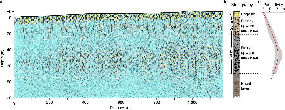
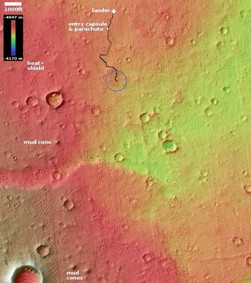
Figure 2 of their paper, posted above, summarizes their results. It shows the radar profile to 328 feet (100 meters) depth along Zhurong’s route, as shown in the map to the right, with the last bit of its recent travels ending somewhere in the blue circle. From the paper:
Our low-frequency radar imaging profile shows radar signals within the depth range of 0–80 m (Fig. 2a), precluding the existence of a water-rich layer within this depth range as the existence of water would strongly attenuate the radar signals and diminish the visibility of deeper reflections. The estimated low (less than 9) dielectric permittivity (Fig. 2c) further supports the absence of a water-rich layer as water-bearing materials typically have high (greater than 15) dielectric permittivity.
We further tested this assessment with thermal considerations by conducting a heat conduction simulation based on available thermal parameters estimated from previous studies (Methods). Our thermal simulation results … show that the Zhurong landing area has an annual average temperature of around 220K in the RoPeR detection depth range, which is much lower than the freezing point of pure water (273K), and also lower than the eutectic temperatures of typical sulfate and carbonate brines, but slightly above those of perchlorate brine systems. This observation suggests that the shallow subsurface of the Zhurong landing area could not stably contain liquid water nor sulfate or carbonate brines, consistent with the radar imaging result.
The data suggests that below the surface topsoil layer, the regolith, there are two distinct layers of material that the scientists interpret as possible evidence of past catastrophic floods. That conclusion however is very very uncertain. The main take-away is that in the northern lowland plains of Utopia Planitia at 25 degrees north latitude, where Zhurong landed, Mars is definitely a dry desert, with no water close to the surface.
This data also suggests that if you establish a colony anywhere in Mars’ dry equatorial regions within 30 degrees latitude of the equator, you will likely have to travel north or south a considerable distance to get to easily accessible ice. The global map of Mars below shows the regions where ice is most evident, north and south of 30 degrees latitude.
» Read more