NASA Inspector General to Congress: Free Europa Clipper from SLS

In a letter to Congress on August 27, 2019, NASA’s inspector general has called for Congress to immediately abandon the legal requirement it imposed on Europa Clipper to fly on NASA’s SLS rocket, thereby allowing NASA to choose any commercial rocket to launch the spacecraft.

The letter [pdf] is amazingly blunt.

[W]e write to highlight an issue at NASA that we believe requires immediate action by Congress. Language in NASA’s appropriation legislation requires the Agency to launch a satellite to Europa, a moon of Jupiter, in 2023 on the yet-to-be-completed Space Launch System (SLS) rocket. However, because of developmental delays and, more significantly, NASA’s plans to use the first three SLS rockets produced for its Artemis lunar program, an SLS will not be available until 2025 at the earliest. Consequently, if completed on its projected schedule, the approximately $3 billion dollar Europa spacecraft (known as “Europa Clipper”) will need to be stored for at least 2 years at a cost of $3 to $5 million per month until an SLS becomes available. NASA recently added $250 million in Headquarters-held reserves to the project to address these storage and related personnel costs.

Congress could reduce risks to both the Europa mission and Artemis program while potentially saving taxpayers up to $1 billion by providing NASA the flexibility in forthcoming fiscal year (FY) 2020 appropriations legislation to determine the most cost effective and timely vehicle to launch the Europa Clipper mission in 2023 or whenever the satellite is completed.

As blunt as the letter is, the wording above is also very careful to hide the fact that the $1 billion savings will come, not from avoiding the launch delay, but from buying a private commercial launch vehicle (estimated launch cost about $100 million) versus using SLS (estimated launch cost of $1 billion to $4 billion).

Will Congress take this advice? It should, though I am pessimistic. Our Congress has not shown much interest in doing the smart thing when it comes to SLS for about a decade. Why should things change now?

SpaceX begins hunt for Starship landing sites on Mars

Candidate landing sites for SpaceX's Starship

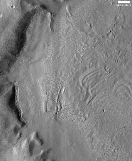
In the August image release from the high resolution camera of Mars Reconnaissance Orbiter (MRO) were five images whose title immediately caught my interest:

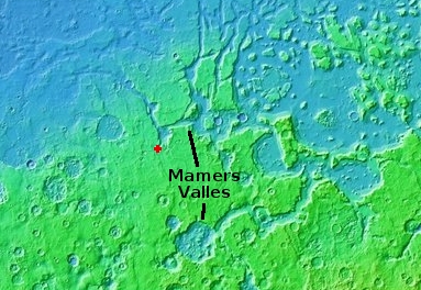
The overview map on the right shows the location on Mars for these five photographs. The second and third images are of the same location, taken to produce a stereo pair.

To put it mildly, it is most intriguing to discover that SpaceX is beginning to research a place where it can land Starship on Mars. I immediately emailed Nathan Williams, the JPL scientist who requested these images from SpaceX, but he was bound by a non-disclosure agreement with SpaceX and could not comment. I have since tried to get some information directly from SpaceX but so far the company has not responded. A 2017 news story had indicated the company’s interest in this Mars’ location, but gave no details either.

Based on what we now know of Mars, however, it is possible to figure out why they favor this location, on the border between the two large northern lowland plains Arcadia and Amazonis Planitia.
» Read more

Astronomers find Jupiter-sized exoplanet with comet-like orbit

Worlds without end: Astronomers have discovered a Jupiter-sized exoplanet with an extremely eccentric and comet-like orbit circling a star about 103 light years away.

Astronomers have discovered a planet three times the mass of Jupiter that travels on a long, egg-shaped path around its star. If this planet were somehow placed into our own solar system, it would swing from within our asteroid belt to out beyond Neptune. Other giant planets with highly elliptical orbits have been found around other stars, but none of those worlds were located at the very outer reaches of their star systems like this one.

This discovery, like so many others, illustrates again our lack of knowledge about the make-up and formation of solar systems. According to modern formation theories, you shouldn’t get such a large exoplanet in such an eccentric orbit. But here we are.

Assembly complete on Europe’s Franklin Mars rover

Engineers have completed the assembly of Europe’s Rosalind Franklin rover that is scheduled for launch to Mars in July 2020

Rosalind Franklin, which is the result of cutting edge work from UK, European and Canadian scientists and engineers will now be shipped from the Airbus factory in Stevenage, Hertfordshire to Toulouse in France for testing to ensure it survives its launch from Earth next summer and the freezing conditions of Mars when it lands on the planet in March 2021.

Whether they can meet this schedule remains unknown because of the problems that occurred during testing of the spacecraft’s landing parachutes.

No warming in U.S. since 2005

NOAA data since 2005
Click for full image.

Using temperature stations specifically picked to eliminate as many biases and temperature errors as possible, NOAA has found that since 2005 the continental United States has experienced no warming at all.

The graph at the right, reduced to post here, illustrates this.

In January 2005, NOAA began recording temperatures at its newly built U.S. Climate Reference Network (USCRN). USCRN includes 114 pristinely maintained temperature stations spaced relatively uniformly across the lower 48 states. NOAA selected locations that were far away from urban and land-development impacts that might artificially taint temperature readings.

Prior to the USCRN going online, alarmists and skeptics sparred over the accuracy of reported temperature data. With most preexisting temperature stations located in or near urban settings that are subject to false temperature signals and create their own microclimates that change over time, government officials performed many often-controversial adjustments to the raw temperature data. Skeptics of an asserted climate crisis pointed out that most of the reported warming in the United States was non-existent in the raw temperature data, but was added to the record by government officials.

The USCRN has eliminated the need to rely on, and adjust the data from, outdated temperature stations. Strikingly, as shown in the graph below, USCRN temperature stations show no warming since 2005 when the network went online. If anything, U.S. temperatures are now slightly cooler than they were 14 years ago.

What is significant about this data is how it reveals the dishonesty of the adjustments that NOAA and NASA have been making to the temperature data. Those adjustments, supposedly done to make the data more accurate, have always cooled the past and warmed the present, a pattern that by itself is very suspicious.

These temperature stations were chosen to create a reliable baseline, picking stations that needed no adjustment and would thus give scientists a measure for justifying any alterations they impose on the raw data. Not only does this data suggest strongly that the claims of global warming year after year (“This year was the hottest on record!”) are suspect, it also shows that there is something seriously wrong with their adjustments. If their modifications to the raw data was correct, then this set of data should have matched it. It does not.

Will this mean they will readjust the overall data to eliminate the cooling in the past and the warming in the near present to make the data better fit what these results prove? Don’t be silly! That would show that there is little merit to the theories of the global warming alarmists, something that cannot be tolerated. It might cause those big government contracts to be cancelled. Worse, it will make it more difficult for these leftists to use the data to justify reshaping society into their vision of a socialist utopia.

No, what I expect to happen is that the scientists at NOAA (who also happen to be the ones who have been tampering with all the other data) to begin altering the temperature data from these baseline stations, to make them fit their theories. Or as Democratic presidential candidate Joe Biden recently put it, “We choose truth over facts.”

Arecibo gets $19 million NASA research/education grant

The Arecibo Observatory in Puerto Rico was today awarded an $19 million NASA research/education grant for studying near Earth asteroids.

NASA awarded the University of Central Florida (which manages the site on behalf of National Science Foundation) the four-year grant to observe and characterize near-Earth objects (NEO) that pose a potential hazard to Earth or that could be candidates for future space missions.

…The award also includes money to support STEM education among high school students in Puerto Rico. The Science, Technology And Research (STAR) Academy brings together 30 local high-school students per semester once a week for 16 classes to learn about science and research at the observatory.

This, plus the recent NSF grant, will keep the telescope operating for at least the next few years.

Global warming scientist Michael Mann loses Canadian lawsuit

Global warming scientist Michael Mann has lost a Canadian libel lawsuit he had filed against a skeptical scientist who had said that Mann “belongs in the state pen, not Penn State.”

More details here. The court also ruled that Mann must pay the defendant’s court costs. The key quote that proves Mann’s scientific work is either incompetent or fraudulent is this:

Dr Mann lost his case because he refused to show in open court his R2 regression numbers (the ‘working out’) behind the world-famous ‘hockey stick’ graph.

Mann is most well known for his hockey stick graph that eliminated any evidence of the well-documented Medieval Warming Period and thus made it appear global warming only began with the industrial age.

Many good scientists have questioned this graph, including Canadian scientist Dr. Tim Ball, the victorious defendant in this case. The court had demanded that to prove Ball’s statement was libel, Mann had to show everyone the legitimate scientific methods he used to create the graph. Mann refused to do so, and so the court ruled against him.

I should add that a number of different scientists have analyzed Mann’s hockey stick graph and have found that, based on the information in Mann’s own published papers, they could plug the data in and with his methods create any graph they wanted, essentially demonstrating that what Mann did was junk.

Does this prove human-caused global warming isn’t happening? No, it doesn’t. What it does demonstrate once again is that another one of the icons of that theory is either a fraud or incompetent, and that his work is not worth the electrons used to publish it. In the case of Mann, the evidence of his political biases and corrupt science practices has been evident for years, first exposed in his emails in the climategate emails. There, he actually worked to destroy the careers of any scientist who questioned his work, rather than debate the facts with them.

He tried to do the same this time with Dr. Ball, and has been soundly slapped down.

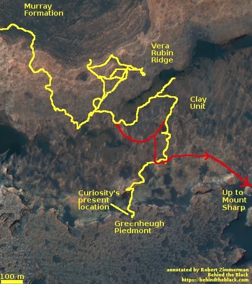
Curiosity’s future travels

Curiosity's planned route up Mt Sharp
Click for full image.

The Curiosity science team has released a new map showing an update of their planned route for Curiosity in the coming year or so, showing how they plan on leaving Gediz Vallis Channel after spending some time exploring the numerous geological layers exposed on its eroded surface.

The new information in this map is the route near the bottom of the image, showing more precisely the route up the canyon and then their retreat through the gap in the canyon’s western wall.

To get a better idea of what this means, I have updated my annotations on this Mars Reconnaissance Orbiter image of Gediz Vallis Channel, posted previously in my May 30, 2019 rover update.
» Read more

At a conference today

Posting will be intermittent, as I am attending a one day conference [pdf] at the University of Arizona being put on by Lunar & Planetary Laboratory.

Tidbits posted as I hear them (these tidbits do not involve new results that are still embargoed):

-Data from OSIRIS-REX at Bennu and Hayabua-2 at Ryugu have found that while both are rubble pile asteroids, there is evidence that suggests that Ryugu, but not Bennu, was subjected to heating in the past. In other words, it had been cooked.

-We presently possess no meteorites with a chemical make-up that matches the data obtained from orbit around Mercury. This isn’t a surprise, as any material thrown from the surface by an impact would not likely have the energy and velocity required to climb up out of the Sun’s gravitation well and get to Earth. Material from Mars however can easily fall into that well, which is why it is not difficult to find meteorites from Mars on Earth.

– Unlike the Earth, where atmospheric circulation in the north and south hemispheres is independent, Titan’s atmosphere is actually one large Hadley Cell, with flow going from one hemisphere to the other, depending on season.

-The evolutionary changes in Neptune’s orbit over time is thought to have caused the high inclination orbits seen in the objects in the Kuiper Belt, which are a mystery since all these objects must have once been confined within the protoplanetary disk, today’s plane of the solar system.

-Despite finding thousands of candidate exoplanets, Kepler found none in the habitable zone. This does not mean habitable exoplanets are rare, but that there were certain biases in Kepler’s observations that caused this lack.

-There is a lot of research going on to study buried ice/glaciers here on Earth. This work is directly aimed at better understanding the many buried glaciers now thought to exist on Mars.

Melting rocks on Mars

Melt pools near Mohave Crater
Click for full image.

Cool image time! The image to the right, reduced, cropped, and annotated by me to post here, was part of the July image download from the high resolution camera on Mars Reconnaissance Orbiter (MRO) and was titled “Melt Pools around Mojave Crater”.

You can see that the flow began to the south, flowed northward (in the middle of the image), and then pooled in the two places as indicated. In the full photograph you can also see that the flow continued to the north, forming more pools.

The title to me suggests that this flow and the melt pools were lava, not ice. The low latitude, 7 degrees north, also suggests this is not ice. Though I was unable to reach the person who requested these images, it appears his research is aimed understanding the melt events that occur in the vicinity of craters upon impact. From his website:
» Read more

Scientists resolve one Mars methane mystery

Scientists have now figured out why the methane data from Curiosity on the Martian surface did not match the methane data from Trace Gas Orbiter in orbit around Mars.

Last year, scientists learned that methane concentrations changed over the course of the seasons with a repeatable annual cycle. “This most recent work suggests that the methane concentration changes over the course of each day,” Dr Moores said. “We were able – for the first time – to calculate a single number for the rate of seepage of methane at Gale crater on Mars that is equivalent to an average of 2.8 kg per Martian day.”

Dr Moores said the team was able to reconcile the data from the ExoMars Trace Gas Orbiter and the Curiosity Rover, which appeared to contradict each other with wildly different detections of methane. “We were able to resolve these differences by showing how concentrations of methane were much lower in the atmosphere during the day and significantly higher near the planet’s surface at night, as heat transfer lessens,” he said.

Solving that data conflict helps them get a better grip on the real question: Why is the methane fluctuating in this manner?

An eroding Martian glacier?

An eroded glacier on Mars?

Close-up of an eroded glacier on Mars?
Click for full image.

Cool image time! In my never-ending review of new images downloaded each month from the high resolution camera of Mars Reconnaissance Orbiter (MRO), I came upon an image dubbed merely “Terrain Sample” in the August release. To the right, cropped and rotated to post here, is the weird terrain from that image, with the section in the white box shown below at full resolution.

To keep MRO functioning properly, they need to take images on a regular basis, even if they have no planned features coming into view. As noted by Singleton Thibodeaux-Yost, the HiRISE Targeting Specialist at the University of Arizona who requested this image,

It was not taken in response to a suggestion from the public or our team database. This image was a ride-along with another instrument on MRO. [The scientists for that other instrument] targeted this region for a particular reason and we just turned on our camera as well to gather more data while they collected their data. I title these types of images “terrain sample” as we don’t always know what the results will be.

In other words, the scientists running the high resolution camera have no inkling what they will see until see it.

This image shows the inside rim of a crater, with the crater rim to the south just beyond the image’s bottom edge. This somewhat large crater is located in the middle of Arabia Terra, one of the largest regions of the transition zone between the southern highlands and the northern lowlands (where some scientists believe an intermittent ocean might have once existed). This transition zone has many features that suggest a tidal basin on the edge of that ocean.

A few months ago I would have been entirely baffled by what we see here. I might have speculated that these strange features were another variation of that shoreline region. Maybe these features are the erosion one sees on a dried lakebed after the water has drained away.

I might have also speculated that these shapes looked like the kind of frozen ice blocks one sees in the icecap of the Arctic here on Earth.

Both speculations then would have been complete guesses.

I now know, based on things I have recently learned in writing about several other images from MRO, that the second guess is likely right (though of course my opinion as a very amateur planetary geologist should not be taken very seriously). My reasons?
» Read more

Data suggests Earth-sized exoplanet has no atmosphere and resembles Mercury

Using archive data from the Spitze Space Telescope astronomers believe that an Earth-sized exoplanet about 49 light years away probably has no atmosphere and is likely similar to Mercury.

Discovered in 2018 by NASA’s Transiting Exoplanet Satellite Survey (TESS) mission, planet LHS 3844b is located 48.6 light-years from Earth and has a radius 1.3 times that of Earth. It orbits a small, cool type of star called an M dwarf – especially noteworthy because, as the most common and long-lived type of star in the Milky Way galaxy, M dwarfs may host a high percentage of the total number of planets in the galaxy.

…The Spitzer observations rule out an atmosphere with more than 10 times the pressure of Earth’s. (Measured in units called bars, Earth’s atmospheric pressure at sea level is about 1 bar.) An atmosphere between 1 and 10 bars on LHS 3844b has been almost entirely ruled out as well, although the authors note there’s a slim chance it could exist if the stellar and planetary properties were to meet some very specific and unlikely criteria. They also argue that with the planet so close to a star, a thin atmosphere would be stripped away by the star’s intense radiation and outflow of material (often called stellar winds).

For a planet to be in the habitable zone of a M dwarf it must orbit very close to the star. This research suggests that conditions that close to the star might still preclude the possibility of life.

Second gas giant found orbiting Beta Pictoris

Astronomers today announced that they have detected another exoplanet orbiting the young star Beta Pictoris 63 light years away.

This time, the team had to analyse more than 10 years of high-resolution data, obtained with the HARPS instrument at ESO’s La Silla Observatory in Chile, in order to indirectly detect the presence of β Pictoris c. This second giant planet, which has a mass nine times that of Jupiter, completes its orbit in roughly 1,200 days, and is relatively close to its star (approximately the distance between the Sun and the asteroid belt, whereas β Pictoris b is 3.3 times more distant).

Because Beta Pictoris has a very large disk of material, astronomers have expected to find exoplanets there for decades. Only in the last two decades have their instruments improved enough to allow the detections. Moreover, because the star is young, astronomers believe it gives them a glimpse into what our solar system looked like during its early formation period.

Parker to extend instrument operations in future solar fly-bys

The engineering and science team for the Parker Solar Probe have decided they can turn on its science instruments for a longer period during future solar fly-bys, and have now done so for its upcoming third approach.

Parker Solar Probe turned on its four instrument suites on Aug. 16, 2019 — earlier than during its previous two solar encounters, extending the observation period from 11 days to about 35 days.

During the spacecraft’s first two solar encounters, the science instruments were turned on when Parker was about 0.25 AU from the Sun and powered off again at the same distance on the outbound side of the orbit. (One AU, or astronomical unit, is about 93 million miles, the average distance between the Sun and Earth.) For this third solar encounter, the mission team turned on the instruments when the spacecraft was around 0.45 AU from the Sun on the inbound side of its orbit and will turn them off when the spacecraft is about 0.5 AU from the Sun on the outbound side.

This decision will allow them to get more data about the solar wind from farther from the Sun.

A directory of skeptical climate websites

Link here. The list is very comprehensive, including many of the sites I check frequently. Note too that many of these sites are very rigorous in the analysis of data, often far more rigorous than many modern peer-reviewed climate papers I read.

As they are skeptical, so should you be. Don’t take anything said at these sites at face value, but don’t dismiss what they say outright either. Pay attention, because you might find that you will become more discerning in the future when you are bombarded with chicken-little pronouncements from the global warming activist crowd.

One quote from the article bears some contemplating:

Virtually all powerful vested interests in the Western hemisphere recognize climate change alarm as leverage to impose self-serving policies and garner higher profits. The reasons for this are myriad. [The article then lists sixteen such reasons, all well known and well documented.]

Taken individually, each of these reasons—and this list undoubtedly omits additional special interests that benefit from climate change alarm—represent a profound shift in public policy. Each of them represents investments skewing away from optimal returns and instead towards returns that favor a politically entitled group. The overall impact of all of them is regressive, increasing the cost-of-living for the most economically vulnerable populations.

Juno finds Jupiter’s core more extended and less dense than predicted

My headline above focuses on the real story here, that Juno has found that Jupiter’s solid core is more fuzzy and extended.

Unfortunately, the press release instead focuses on one theory, based on computer models, that might explain this discovery.

The research team ran thousands of computer simulations and found that a fast-growing Jupiter can have perturbed the orbits of nearby “planetary embryos,” protoplanets that were in the early stages of planet formation.

Liu said the calculations included estimates of the probability of collisions under different scenarios and distribution of impact angles. In all cases, Liu and colleagues found there was at least a 40% chance that Jupiter would swallow a planetary embryo within its first few million years. In addition, Jupiter mass-produced “strong gravitational focusing” that made head-on collisions more common than grazing ones.

Isella said the collision scenario became even more compelling after Liu ran 3D computer models that showed how a collision would affect Jupiter’s core. “Because it’s dense, and it comes in with a lot of energy, the impactor would be like a bullet that goes through the atmosphere and hits the core head-on,” Isella said. “Before impact, you have a very dense core, surrounded by atmosphere. The head-on impact spreads things out, diluting the core.”

This theory is all well and good, but we mustn’t take it too seriously. It relies entirely on computer models, and carries with it enormous assumptions about the early solar system that are as yet unproven.

That Jupiter’s core however is fuzzy and extended however is quite fascinating, highlighting once again how little we know about the universe.

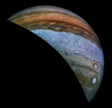
Jupiter’s changing Great Red Spot, as seen by Juno

Montage of Jupiter's Great Red Spot since 2017
Click for full image.

Citizen scientist Björn Jónsson has compiled the montage to the right, reduced to post here, of the five times Jupiter’s Great Red Spot (GRS) was imaged by Juno during its repeated orbital fly-bys.

The mosaics show how the GRS and nearby areas have changed over the course of the Juno mission. The mosaics cover planetographic latitudes 4.7 to 38 degrees south.

The resolution of the source data is highly variable and this can be seen in some of the mosaics. The viewing geometry also varies a lot. Some of the images were obtained almost directly above the GRS (in particular some of the perijove 7 images) whereas other images were obtained at an oblique viewing angle (in particular the perijove 17 images).

These are approximately true color/contrast mosaics but there may be some inaccuracies in areas where the original images were obtained at a highly oblique angle. The contrast is also lower in these areas.

Some of the changes are remarkable, considering the short time involved. For example, note the appearance of the large white storm below the Spot in the third image, taken in December 2018. It wasn’t there in April 2018, and was gone by Feburary 2019. This doesn’t mean it had dissipated. Instead, the storm is in a different band which moves at a different speed than the band that the Spot is in. It has thus simply moved away.

This movement is even more remarkable when we remember that the Great Red Spot is about the width of the Earth.

Arecibo gets $12.3 million NSF grant

The National Science Foundation has awarded the Arecibo radio telescope in Puerto Rica a $12.3 million grant to pay for needed repairs and upgrades following the hurricane damage from 2017.

The money will pay for the following work:

  • Repairing one of the suspension cables holding the primary telescope platform, ensuring long-term structural integrity of one of the main structural elements of the telescope.
  • Recalibrating the primary reflector, which will restore the observatory’s sensitivity at higher frequencies.
  • Aligning the Gregorian Reflector, improving current calibration and pointing.
  • Installing a new control system for S band radar, which is part of the microwave band of the electromagnetic spectrum.
  • Replacing the modulator on the 430 MHz transmitter, increasing consistency of power output and data quality.
  • Improving the telescope’s pointing controls and data tracking systems.

Most of this looks to be very basic maintenance, which suggests the telescope is still very starved for funds.

Amateur finds moon orbiting comet in Rosetta archive

In mining the Rosetta archive of images of Comet 67P/C-G, an amateur astronomer has discovered a twelve-foot-diameter chunk of material that had broken from the comet and was in orbit around it.

Modelling of the Rosetta images indicates that this object spent the first 12 hours after its ejection in an orbital path around 67P/C-G at a distance of between 2.4 and 3.9 km from the comet’s centre. Afterwards, the chunk crossed a portion of the coma, which appears very bright in the images, making it difficult to follow its path precisely; however, later observations on the opposite side of the coma confirm a detection consistent with the orbit of the chunk, providing an indication of its motion around the comet until 23 October 2015.

While it is not really unusual for their to be small objects in the coma of the the comet, orbiting it, this is apparently the largest so far found. That they missed it initially is also not surprising, considering the amount of data they were gathering in such a short time.

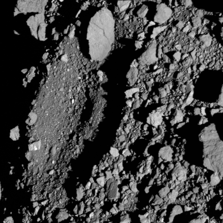
OSIRIS-REx team picks four finalist sample return sites on Bennu

After months of photographing and analyzing the very rocky-shrewn surface of the rubble-pile asteroid Bennu, the OSIRIS-REx team has chosen four finalist sites, one of which they will do a touch-and-go sample grab.

This fall, OSIRIS-REx will begin detailed analyses of the four candidate sites during the mission’s reconnaissance phase. During the first stage of this phase, the spacecraft will execute high passes over each of the four sites from a distance of 0.8 miles (1.29 km) to confirm they are safe and contain sampleable material. Closeup imaging also will map the features and landmarks required for the spacecraft’s autonomous navigation to the asteroid’s surface. The team will use the data from these passes to select the final primary and backup sample collection sites in December.

The second and third stages of reconnaissance will begin in early 2020 when the spacecraft will perform passes over the final two sites at lower altitudes and take even higher resolution observations of the surface to identify features, such as groupings of rocks that will be used to navigate to the surface for sample collection. OSIRIS-REx sample collection is scheduled for the latter half of 2020, and the spacecraft will return the asteroid samples to Earth on Sept. 24, 2023.

They given the four sites the names Nightingale, Kingfisher, Osprey and Sandpiper.

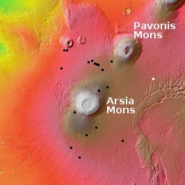
Monitoring Martian pits not near Arsia Mons

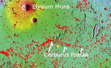
Second look at Hephaestus Fossae pit
Click for full image.

In reviewing the August image release from the high resolution camera on Mars Reconnaissance Orbiter (MRO), I came upon two different new pit images, the more interesting of which is highlighted on the right, cropped to post here..

Finding new pit images from MRO isn’t surprising, since the spacecraft has been photographing pits almost monthly since November (see: November 12, 2018, January 30, 2019, February 22, 2019, April 2, 2019, May 7, 2019, and July 1, 2019).

What makes these two new pit images more intriguing are their location, and the fact that both pits were previously photographed by MRO and posted on Behind the Black on June 5, 2018 and July 24, 2018. Both are located in Hephaestus Fossae, a region of fissures on the edge of the great Martian northern lowlands to the west of the great volcano Elysium Mons.

Almost all the pits from past MRO images have been found on the slopes of Arsia Mons, the southernmost of the three giant volcanoes southeast of Olympus Mons. In fact, last month I even asked the question, “Why so many pits there, and so few pits elsewhere?” The explanation from Chris Okubo of the U.S. Geological Survey, who is requesting these images, was that maybe it was due to geology, or maybe it was because we simply do not yet have enough information and might not have identified the many caves/pits elsewhere.

It appears that this same question had already been on the minds of Okubo and his partner, Glen Cushing, also of the USGS. As Okubo wrote me when I asked him about these new images:
» Read more

Forbes censors climate article questioning human-caused global warming

An August 9th article at the magazine Forbes — discussing the skepticism that many scientists have about human-caused global warming — was removed today by the magazine “for failing to meet our editorial standards.”

Or to put it more accurately, they censored it for failing to follow the knee-jerk blind demands of the global-warming political movement.

The Global Warming Policy Foundation (GWPF) has now published the article in full, so that “interested readers [can] make up their own minds about the research by Nir Shaviv and Henrik Svensmark.”

Read the article. The only things unreasonable in it is the suggestion that there is a 97% consensus among climate scientists. That claim is false, as noted by the authors of the paper [pdf] where the claim comes from, in their own abstract.

We find that 66.4% of abstracts expressed no position on AGW [human-caused global warming], 32.6% endorsed AGW, 0.7% rejected AGW and 0.3% were uncertain about the cause of global warming.

What these statistics actually prove is that 66.4% of all climate scientists understand that it is inappropriate to endorse or even reject a theory, when the data is insufficient. The remaining third, whether they endorse or reject human-caused global warming, do not understand the scientific method, in the slightest.

As for the censored Forbes article, it first outlines some of the most reasonable uncertainties of science surrounding the climate, focusing most specifically on the influence of the Sun, as shown by research by Shaviv and others. Then it notes how the climate community is working to squelch such research, dishonestly, as noted by Shaviv:

Any scientist who rejects the UN’s IPCC report, as he does, will have trouble finding work, receiving research grants or publishing, he said.

I must add that I have interviewed Nir Shaviv myself in connection with several astronomy articles, and found him to be a rigorous and intelligent scientist interested only in pursuing knowledge and the truth.

The bottom line now however is that the pursuit of knowledge and truth is no longer allowed in the climate field. Step out of line and the modern global warming inquisition will move in quickly to silence you, to smash its jack-booted foot into your face.

Hat tip to one of my readers, who when he sent this article to me opened by quoting me and Scott Adams: “They’re coming for you next.” Fortunately, I have tried very hard to anticipate such attacks, which is why I created Behind the Black. This website has made me free and independent of such oppressive tyranny. The only thing that would stop me from expressing my thoughts freely would be a lack of support from my readers. Fortunately, my readers have been increasingly generous, suggesting that they like the idea of freedom and open debate.

Reports of another ExoMars parachute failure during test

Following a failure of ExoMars’ parachutes during a May test, there are now reports that a second failure occurred on August 5.

A fresh test of the parachute system for the Russian-European mission ExoMars-2020 have failed again as a structural mockup of the Russian-built lander crashed during the simulated landing, a source familiar with the test results told Sputnik.

The test with the use of a high-altitude balloon was carried out on August 5 at a Swedish Space Corporation’s test site in northern Sweden.

“Tests of the parachute system at the Esrange test site in Sweden failed. A full-size mockup of the landing module of the ExoMars-2020 Martian station crashed during the landing,” the source said.

I have seen this report in two other sites, but it has not yet been confirmed by the European Space Agency.

If these reports are true, the chances of ExoMars launching in July 2020 is likely almost nil. They haven’t even begun assembling the spacecraft, and have had two parachute failures in tests, with the second destroying the prototype used for those tests.

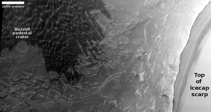
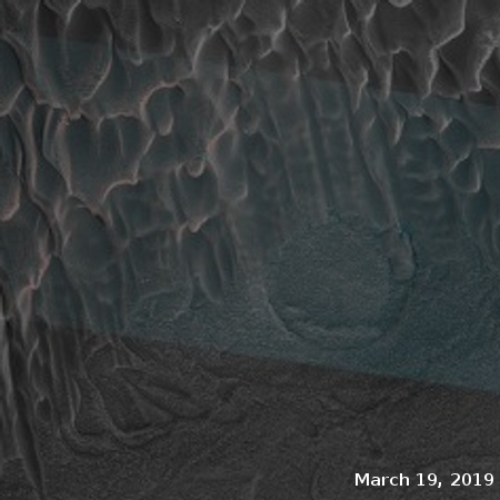
Watching the yearly vanishing of Mars’ north pole dry icecap

Buzzell dunes, March 19, 2019
Click for full image.

Buzzel dunes, April 4, 2019
Click for full image.

Buzzell dunes, June 4, 2019
Click for full image.

For the northern hemisphere of Mars it is presently spring. The season began sometime in April 2019 and will last until about October, twice as long as on Earth because of the Martian year is twice as long.

During the fall and winter the permanent water-icecap, which forms the bulk of the Martian icecap, gets covered by a mantle of dry ice, settling there as a layer of carbon dioxide snow about six feet thick. With the arrival of spring that dry icecap slowly begins sublimate away entirely.

Using the high resolution camera on Mars Reconnaissance Orbiter (MRO) planetary scientists are monitoring this process, taking pictures periodically.

On June 6, 2019 I had written a detailed story describing the Martian North Pole and outlining the process by which this sublimation of the dry icecap mantle takes place.

When winter ends and the sun reappears at this Arctic location, a small percentage of that sunlight, about 10%, goes through the dry ice and warms the sand that the dry ice mantles. This in turn warms the bottom of the dry ice layer, causing this to sublimate into a gas that is now trapped.

When the pressure builds sufficiently, that gas breaks free at the weakest spots in the dry ice layer, which are either at the dune crest or at its base, or sometimes on its face where cracks form. When it does so the CO2 gas carries with it material from below, which appears dark relative to the bright dry ice on the surface. As the summer season progresses and more dry ice sublimates away, the dark smudges disappear as they slowly blend in with the now-exposed original sand surface.

The first two pictures to the right were posted in that June 6, 2019 story, showing the initial evidence of sublimation on a set of dunes that the scientists have dubbed Buzzell. Below these, I have now added the newest image of the Buzzell dunes, taken on June 4, 2019 and just released in the August MRO image dump.

When this third image was taken, spring was only about two months old. Yet, this sublimation process is clearly accelerating. You can see many more dark patches at the crests and bases of many dunes, especially in the upper left of the image. According to Dr. Candice Hansen of the Planetary Science Institute in Tucson, Arizona, who is requesting these monitoring images, by sometime in October “you’ll see how the entire spring progresses from dunes completely covered with dry ice to the summer when they are just bare sand. Then you could comment on the whole spring series.”

I fully intend to do this. No harm however in providing an interim report or two. Stay tuned to Behind the Black for future on-going and up-to-date reports on the shrinking north pole dry icecap of Mars!

IAU approves 2nd set of Pluto names chosen by New Horizons team

My heart be still! The International Astronomical Union (IAU) has now officially given its glorious stamp of approval to a second set of fourteen names given by the New Horizons’ team to features on Pluto.

Several people and missions who paved the way for the historic exploration of Pluto and the Kuiper Belt – the farthest worlds ever explored – are honored in the second set of official Pluto feature names approved by the International Astronomical Union (IAU), the international authority for naming celestial bodies and their surface features.

The new names were proposed by NASA’s New Horizons team, which carried out the first reconnaissance of Pluto and its moons with the New Horizons spacecraft in 2015. Along with a short list of official names the IAU had already approved, the mission science team had been using these and other place names informally to describe the many regions, mountain ranges, plains, valleys and craters discovered during the first close-up look at Pluto’s surface. [emphasis mine]

In case you don’t get it, I am being very sarcastic above. I consider the IAU to be incredibly arrogant in its claim that it, and it alone, can approve the names given to surface features on other worlds. Initially the IAU was given the task by the astronomical community of organizing the naming of celestial bodies seen in telescopes, to reduce confusion. Somehow the IAU has expanded that responsibility to include the naming of every rock and pebble on every world in the universe.

To this I say bunk. I also know that future spacefarers in space will say the same thing, and tell the IAU to go jump in a lake. In a sense, the New Horizons team did exactly that when they made their name choices very public from the beginning, essentially telling the IAU that the New Horizons’ team is picking the names, not the IAU.

In related news, the IAU has now approved the naming convention the OSIRIS-REx team intends to use to name features on Bennu. However, in this case the IAU is doing its real job, helping to organize the naming conventions to reduce confusion.

The named features on Bennu will include several terrain classification types that the IAU also approved for asteroid (162173) Ryugu’s surface features (currently being explored by the Japanese Space Agency’s Hayabusa2 spacecraft). These include craters, dorsa (peaks or ridges), fossae (grooves or trenches) and saxa (rocks and boulders). The last of these types – saxum – is a new feature classification that the IAU introduced earlier this year for small, rocky asteroids like Ryugu and Bennu. These surface features on Bennu will be named after mythological birds and bird-like creatures, complementing the mission’s existing naming theme, which is rooted in Egyptian mythology.

The actual names the OSIRIS-REx team will chose for each unique feature will however be their choice, not the IAU’s. Though the IAU will eventually announce it has “approved” those choices, it will never really have the right to have a say in those decisions.

New Hubble image of Jupiter

Jupiter as seen by Hubble in 2019
Click for full image.

The Hubble science team today released a new global image the telescope took of Jupiter on June 27, 2019. The photograph on the right is that image, reduced and cropped to post here. As noted by the press release about the Great Red Spot,

The Great Red Spot is a towering structure shaped like a wedding cake, whose upper haze layer extends more than 3 miles (5 kilometers) higher than clouds in other areas. The gigantic structure, with a diameter slightly larger than Earth’s, is a high-pressure wind system called an anticyclone that has been slowly downsizing since the 1800s. The reason for this change in size is still unknown.

A worm-shaped feature located below the Great Red Spot is a cyclone, a vortex around a low-pressure area with winds spinning in the opposite direction from the Red Spot. Researchers have observed cyclones with a wide variety of different appearances across the planet. The two white oval-shaped features are anticyclones, like small versions of the Great Red Spot.

Another interesting detail is the color of the wide band at the equator. The bright orange color may be a sign that deeper clouds are starting to clear out, emphasizing red particles in the overlying haze.

In many ways Hubble’s images of Jupiter are comparable to those taken by Juno, except that Hubble can’t zoom in as close.

Crater on the Basement of Mars

Crater in the bottom of Hellas Basin
Click for full image.

Cool image time! In the July release of images from the high resolution camera of Mars Reconnaissance Orbiter (MRO) was the image to the right, cropped to post here, showing what I suspect is a relatively young crater located in the lowest part of Hellas Basin, what I call the bottom of Mars.

Though this crater is not located at the lowest point in Hellas, it is not far off from there. What makes it important to geologists are two facts. First, there are not a lot of craters in Hellas, which helps indicate it is a relatively young feature. Second, and more important, the impact has made accessible material from below the surface, indicated by the different colors in this image. From this information they can better constrain their theories about the Basin’s formation and where it fits in Mars’s overall geological history.

Make sure you take a look at the full photograph by clicking of the image, and compare it with the earlier Hellas Basin images I posted here. The surface of Hellas appears to have a lot of flow features, as if it was laid down by volcanic activity, or by the motion of water that covered it. In either case that would explain the overall lack of craters.

Yutu-2 and Chang’e-4 go to sleep again

Yutu-2's travels

Both Yutu-2 and Chang’e-4 have been put in dormant mode after completing their eighth lunar day on the far side of the Moon.

The article at the link provides a lot of new details about what both spacecraft have learned and done since they landed, including a nice detailed map showing Yutu-2’s exact path during those eight lunar days. The image to the right, reduced to post here, was taken by Yutu-2, and shows the rover’s tracks during what appears to be its seventh lunar day. It appears that the rover periodically stopped and did a pirouette, probably to obtain a 360 degree mosaic of the surrounding terrain.

Yutu-2’s travels have tended west from Chang’e-4, and on its eighth lunar day it continues that route, traveling 271 meters. After a period of short traveling days, they have now upped the distance traversed by a considerable amount. Since the planned nominal mission for both spacecraft had been three lunar days, both are demonstrating that the Chinese have figured out how to do this, and are now pushing Yutu-2 hard as a result.

The article vaguely describes some of the science obtained so far, but in general the Chinese remain tight-lipped about most of their discoveries.

1 110 111 112 113 114 279