Starliner’s return delayed again

NASA today announced that the return of Starliner from ISS, carrying two astronauts, has been delayed again, from June 18th to June 22nd.

It appears engineers want to perform more tests of the the spacecraft’s attitude thrusters before undocking. The failure of some thrusters during docking on June 6th has raised some concerns.

NASA and Boeing teams also prepared plans for Starliner to fire seven of its eight aft-facing thrusters while docked to the station to evaluate thruster performance for the remainder of the mission. Known as a “hot fire test,” the process will see two bursts of the thrusters, totaling about a second, as part of a pathfinder process to evaluate how the spacecraft will perform during future operational missions after being docked to the space station for six months. [emphasis mine]

The highlighted words are kind of a lie. While there is no doubt this test will tell engineers a lot about future operations, such a test, while attached to ISS, would never have been approved had the thrusters all worked as planned during docking. The real reason for this static fire test is to make sure the thrusters will work once undocked.

If they don’t work, there could be a safety issue putting the astronauts in Starliner for return to Earth.

NASA plans a press briefing on June 18th at noon (Eastern) to outline in better detail the situation.

14 comments

Study: Dust removal at Jezero 9x greater than InSight landing area

Figure 2 from the paper
Figure 2 from the paper. Click for original.

Using data from the Mars rover Perseverance, scientists have concluded that dust removal rate in Jezero crater is almost ten times greater than where InSight landed in western Elysium Planitia.

The graph, figure 2 from their paper, illustrates that differents starkly. From their abstract:

Dust removal is almost 10 times larger than at InSight’s location: projections indicate that surfaces at Jezero will be periodically partially cleaned. The estimations of the effect of the accumulated dust as a function of time are encouraging for solar-powered missions to regions with similar amounts of dust lifting, which might be determined from orbital data on where dust storms originate, dust devils or their tracks are found, or seasonal albedo changes are noted.

In other words, it might be practical to send solar powered rovers to different places on Mars, if first research was done to see if the conditions there would regularly clear dust from those panels.

This research confirms what had been implied by the different experiences of landers/rovers in different places on Mars. InSight landed near the equator in a region south of the giant shield volcano Elysium Mons. It only survived four years, with steadily lower energy levels, because no wind or dust devil ever cleared the accumulating dust on its solar panels. Spirit meanwhile landed about 1,500 miles southwest of InSight, yet its power levels were still healthy after more than five years of operations, when those operations ended because the rover could no longer move. The rover Opportunity meanwhile on the other side of the planet lasted more than fourteen years. Both rovers relied on solar power, like InSight, but their solar panels kept getting cleared of dust by wind and dust devils.

It is unclear if this wind research has been done for Europe’s Franklin rover, presently scheduled to land in Oxia Planum in 2028. Franklin will rely on solar panels, and though its nominal mission on the surface is only supposed to last seven months, it is always assumed it will continue until the rover fails.

0 comments

Astronauts cancel ISS spacewalk due to “spacesuit discomfort issue”

UPDATE: A later update by NASA provided no new information on why the spacewalk was canceled, but did announce a new date for the EVA, June 24th, while adding “The crew members on the station are healthy, and spacesuits are functioning as expected..”

My guess is that one of the astronauts had a personal but minor health issue, that out of privacy concerns NASA cannot reveal.

Original post:
——————
A spacewalk planned for today was postponed when the two astronauts involved stopped putting on their spacesuits and instead put them aside “due to spacesuit discomfort issue.”

That is all we know at this point. Was the issue a technical problem with the suits? Or was it something related to the astronauts themselves, such as one experienced stomach problems for instance?

No more details are as yet available. The NASA-designed American spacesuits used on spacewalks on ISS are very complicated and prone to technical problems. If that was the cause it could result in a serious delay before the next spacewalk takes place.

7 comments

FAA announces schedule for new EIS public meetings on SpaceX’s Starship/Superheavy operations at Cape Canaveral

FAA has now announced the schedule of public meetings in connection with the new environmental impact statement (EIS) it is doing for SpaceX’s proposed Starship/Superheavy operations at Cape Canaveral.

On June 12 and 13, the Federal Aviation Administration (FAA) will host a series of public scoping meetings to inform the public and answer questions about SpaceX’s proposal to launch Starship from Launch Complex 39A (LC-39A). There will also be a virtual meeting on June 17 for those unable to attend in person.

…Among those attending the public hearings will be representative of the Department of the Air Force, the U.S. Space Force, the U.S. Coast Guard, U.S. Fish and Wildlife Service, the Merritt Island National Wildlife Refuge, Canaveral National Seashore and SpaceX.

FAA officials claim this new EIS is required, after doing one only five years ago, because of major changes in SpaceX’s design of Superheavy. For example, it originally planned to land the rocket on a drone ship. Now it wants to catch it with the arms on the launch tower.

The FAA’s argument for this new EIS might sound plausible at first glance, but these regulations were never intended to require new environmental statements every time a project underwent changes. The goal was to make sure the environment would not be impacted by the work, and the first 2019 EIS achieved that. None of the changes SpaceX is proposing change significantly its impact on the local environment.

Moreover, the FAA has three-quarters of a century of empirical data at Cape Canaveral proving that spaceports help the local environment, not hurt it. We know without doubt that none of SpaceX’s launch plans will do harm. The FAA should get out of the way.

Instead, it is sticking its nose into everything. This new EIS is merely mission creep, government bureaucrats both covering their backsides while creating new work that increases their power and justifies bigger budgets for their existence.

0 comments

Review of 4th Superheavy/Starship flight; FAA clears SpaceX for next flight

Link here. The article provides a detailed step-by-step review of everything that happened on the fourth Superheavy/Starship orbital test flight on June 6, 2024, as well as describing the changes being applied to Starship and Superheavy due to that flight.

However, the article also included this announcement from the FAA, stating that it will not do its own mishap investigation on that flight.

The FAA assessed the operations of the SpaceX Starship Flight 4 mission. All flight events for both Starship and Super Heavy appear to have occurred within the scope of planned and authorized activities.

While this decision means SpaceX can go ahead with the fifth test launch as soon as it is ready — no longer delayed while it waits for the FAA to retype SpaceX’s investigation and then approve it — it is unclear whether this FAA decision will allow SpaceX to attempt a tower landing of Superheavy, with the tower’s arms catching the rocket.

If the FAA has not yet approved a tower landing, I suspect SpaceX will forgo that attempt on the next launch in order to get it off the ground as soon as possible, even as it pushes the FAA for such an approval for a subsequent launch.

5 comments

NASA accidently airs simulated medical emergency on ISS, panicking the public

NASA yesterday accidently aired an on-going drill where ground astronauts were simulating a serious medical emergency, causing public alarm because it appeared the emergency was on ISS itself.

The regular scheduled livestream was interrupted at 6:28 p.m. ET by an unidentified speaker — apparently a flight surgeon — liaising with the crew on the ISS on how to deal with a commander suffering from serious compression sickness.

The speaker advises the crew to “check his pulse one more time,” before placing the stricken astronaut inside a suit pumped full of pure oxygen. She says any action would be “best effort treatment” and better than doing nothing. “Unfortunately, the prognosis for Commander is relatively tenuous,” she says.

She says she is “concerned that there are some severe DCS [decompression sickness] hits” and tells the crew to get him in a suit as soon as possible. She mentions that there is a hospital in San Fernando, Spain, with hyperbaric treatment facilities, in an apparent suggestion of ordering an emergency evacuation from the space station.

But after fueling alarm among the space enthusiasts listening, NASA revealed that the scenario wasn’t real — the ISS crew were all safely asleep at the time.

It appears this was a training exercise on the ground. For reasons that have not been explained, the audio somehow got rerouted onto NASA’s public live stream channel, forcing the agency to quickly issue an explanation.

1 comment

Armenia signs Artemis Accords

Armenia, formerly part of the Soviet Union, has now joined the American space alliance by signing the Artemis Accords, becoming the 43rd nation to do so.

This announcement came on the same day Armenia’s prime minister announced that the country was also leaving the Collective Security Treaty Organization (CSTO), created after the break-up of the Soviet Union and created from former U.S.S.R. provinces that are now separate nations.

Armenia’s ties with Russia, its long-time sponsor and ally, have grown increasingly strained after Azerbaijan waged a lightning military campaign in September to take the Karabakh region, ending three decades of ethnic Armenian separatist rule there.

Armenian authorities accused Russian peacekeepers who were deployed to Nagorno-Karabakh after a previous round of hostilities in 2020 of failing to stop Azerbaijan’s onslaught. Moscow, which has a military base in Armenia, rejected the accusations, arguing that its troops didn’t have a mandate to intervene.

It could also be that Armenian sees Russia as a hostile power, considering its invasion of the Ukraine. Russia’s failure to win quickly in the Ukraine and the bogged down nature of the war also make this a very good moment to break free from Russia. Putin doesn’t have the resources to invade another neighbor.

The Artemis Accords now includes these nations: Angola, Argentina, Armenia, Australia, Bahrain, Belgium, Brazil, Bulgaria, Canada, Colombia, Czech Republic, Ecuador, France, Germany, Greece, Iceland, India, Israel, Italy, Japan, Lithuania, Luxembourg, Mexico, the Netherlands, New Zealand, Nigeria, Peru, Poland, Romania, Rwanda, Saudi Arabia, Singapore, Slovakia, Slovenia, South Korea, Spain, Sweden, Switzerland, the United Kingdom, the United Arab Emirates, the Ukraine, the United States and Uruguay.

Whether it will do much depends wholly on what the U.S. does. Right now, the American government’s space effort is confused and incoherent. There is a lot of money being spread around, but not much getting accomplished.

0 comments

A new Chicken Little report: The mega satellite constellations are going to destroy the ozone layer!

The American Geophysical Union, where science is no longer practiced
The American Geophysical Union, where
science is no longer practiced

We’re all gonna die! According to a new paper touted today by the PR department of the American Geophysical Union (AGU), a new study has concluded — based on computer modeling — that the many giant satellite constellations totaling tens of thousands of satellites pose a risk to the ozone layer because the aluminium used in their structures that gets vaporized upon re-entry will interact with the ozone layer and destroy it.

You can read the paper here. From the abstract:

This paper investigates the oxidation process of the satellite’s aluminum content during atmospheric reentry utilizing atomic-scale molecular dynamics simulations. We find that the population of reentering satellites in 2022 caused a 29.5% increase of aluminum in the atmosphere above the natural level, resulting in around 17 metric tons of aluminum oxides injected into the mesosphere. The byproducts generated by the reentry of satellites in a future scenario where mega-constellations come to fruition can reach over 360 metric tons per year. As aluminum oxide nanoparticles may remain in the atmosphere for decades, they can cause significant ozone depletion.

The uncertainties and biases here are hard to count. First, it is a computer model (“Garbage in, garbage out”). Second, the simulations make many assumptions, most of which cannot be confirmed, or are simply absurd. For example, the model is based on a single “typcial, small satellite” coming from a specific orbit and elevation when we know these satellites will have many variations in size, make-up, and orbits. Third, the scientists admit they use “a worst-case scenario” for determining what would happen when the satellite re-enters the atmosphere.

Finally, and most damning, the whole premise of this threat is based on a somewhat implausive chain of chemical actions.
» Read more

16 comments

Perseverance looks up at the rim of Jezero Crater

Panorama on June 10, 2024 by Perseverance
Click for full resolution. For original images, go here, here, here, and here.

Overview map
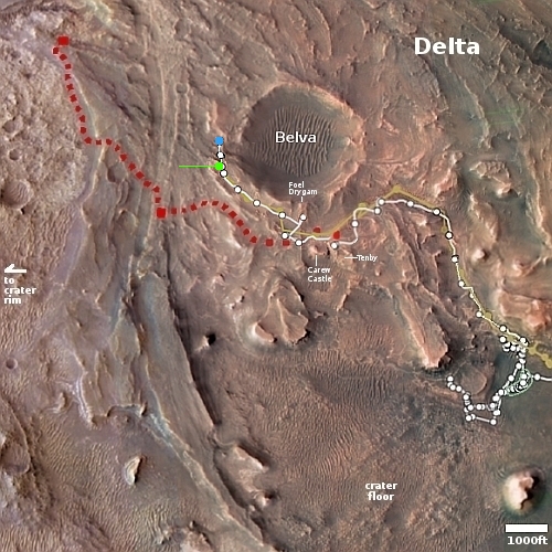
Click for interactive map.

Cool image time. The panorama above was created from four pictures taken on June 10, 2024 by the left navigation camera on the Mars rover Perseverance (captions found here, here, here, and here). It looks north at the nearest hill that forms the north part of the rim of Jezero Crater.

The overview map to the right provides context. The blue dot marks Perseverance’s present location, when it took these pictures. The yellow lines indicate the approximate area covered by the panorama. The red dotted line marks the rover’s planned route, while the white dotted line the route it has actually taken.

Because the rover is now at the base of this hill, it can no longer see the top of the crater’s rim. What it sees instead is the barren foothills of that rim, covered with dust, dunes, and many broken rocks.

As I have noted numerous times, the utter lack of life marks this as a truly alien landscape, compared to Earth. Nowhere on our home planet would you see terrain this empty of life. While NASA likes to claim that Perseverance’s main mission is the search for life on Mars, that claim is always a lie. It is very unlikely any life is going to be found here by Perseverance, and if that was its true scientific purpose it would never have been built nor launched.

What the scientists are doing is studying the alien geology of Mars, to try to understand how this utterly alien planet got to be the way it is now. Such knowledge is critical for the future explorers of space, as it will make it easier for them to understand the alien landscapes they will find elsewhere, within the solar system and eventually in other solar systems far beyond.

0 comments

Curiosity sees evidence of solar storm hitting Mars

Charged particles from solar storm
Click to see original three-frame movie.

Cool image time! The picture to the right is a screen capture from a three-frame movie created from photos taken by one of the navigation cameras on the Mars rover Curiosity. The white streak and other smaller streaks were created by charged particles hitting the camera’s CCD detector on May 20, 2024, from a solar storm caused by the strong solar flares presently being pumped out by the Sun.

The mission regularly captures videos to try and catch dust devils, or dust-bearing whirlwinds. While none were spotted in this particular sequence of images, engineers did see streaks and specks – visual artifacts created when charged particles from the Sun hit the camera’s image detector. The particles do not damage the detector.

The images in this sequence appear grainy because navigation-camera images are processed to highlight changes in the landscape from frame to frame. When there isn’t much change — in this case, the rover was parked — more noise appears in the image.

Curiosity’s Radiation Assessment Detector (RAD) measured a sharp increase in radiation at this time – the biggest radiation surge the mission has seen since landing in 2012.

The view of this picture is to the south, looking towards the top of Mount Sharp, though that peak, more than 25 miles away, is not visible because the mountain’s lower flanks are in the way. A second movie showing similar charged particle streaks was taken looking south, with the rim of Gale Crater barely visible 20-30 miles away.

0 comments

SpaceX retrieves its Dragon debris that fell in Canada in February

SpaceX yesterday sent a crew and a U-Haul truck to five different farms in Saskatchewan, Canada, to retrieve eight pieces of debris that came from the service module trunk of a Dragon cargo capsule when the trunk was de-orbited to burn up in the atmosphere in February.

I am certain SpaceX engineers want to find out why this debris survived its fall through the atmosphere, so as to better predict what will happen on future de-orbits. If they determine that more of Dragon’s service module survives re-entry than previously predicted, it will require a rethinking on where such de-orbits are planned, making sure they always occur over the ocean.

It also appears that an academic who doesn’t know much about space engineering showed up during this retrieval to talk to the press and attack SpaceX.

Samantha Lawler, a University of Regina astronomy professor, was at the farm when SpaceX employees arrived on Tuesday. She said SpaceX needs to be transparent about how its operations are affecting the atmosphere, and how incidents like this are dealt with.

Lawler was quoted more fully (and more embarrassingly) in this other news report:

“SpaceX has over 6,000 Starlink satellites in orbit that they claim will burn up completely when they re-enter. That comes to 23 re-entries per-day when they are at full capacity. If those re-entries are all making it to the ground, dropping hundred pound pieces of garbage, that will kill lots of people,” Lawler explained.

To claim that any Starlink satellites are threat to hit the ground proves Lawler knowns nothing about space engineering and is acting merely as a anti-SpaceX “Karen” who wants to harass the company. Starlink satellites are too small to pose a threat. Moreover, SpaceX from day one has acted responsibly to de-orbit them under a controlled manner.

Nonetheless, this incident in Canada suggests that more material from larger orbiting objects can reach the ground, and requires a rethinking as to where to de-orbit them.

3 comments

The gullies on Mars are caused by a variety of factors, linked to both water and carbon dioxide

The global distribution of gullies on Mars
Click for original image.

In doing a detailed global analysis of all the known gullies on Mars, scientists now believe the gullies are formed by a variety of factors, linked to both water and carbon dioxide as well as the planet’s radically changing rotational tilt — varying from 11 to 60 degrees — over time.

Noblet’s paper articulates a “hierarchy of factors” that describes where gullies occur, with well-supported explanations as to why they form in one place and not another. None of the explanations in this paper are new. What’s new is how Noblet and coworkers reconcile apparent contradictions and inconsistencies among other researchers’ explanations of gully formation, explaining why an explanation that works for one spot on Mars doesn’t work in another.

The map above, from their paper, shows the global distribution of the gullies, which appear to favor the same mid-latitudes where the planet’s glaciers are mostly found. The data from many different studies suggests that when the planet’s rotational tilt was high, these mid-latitudes regions were warmer, and the near-surface ice there would sublimate away to get redeposited at the poles. When this happened the sublimation would cause the pole-facing gullies to form.

The paper also suggests that any gullies changing today are likely the result of the sublimation of carbon dioxide, not water.

There is a lot more at the article at the link, which is an excellent summation of this research.

0 comments
1 227 228 229 230 231 1,329