
Chandra data finds the Milky Way is bigger in size than previously believed
Click for original movie.
Using X-ray data from both the X-ray space telescopes Chandra and XMM-Newton, scientist now think the Milky Way is bigger in size than previously believed, with its three outer arms winding around the galactic center at a greater distance.
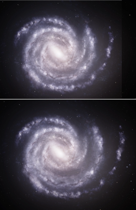
The two artist conceptions to the right show the difference before and after. The top image shows the previously conceived positions of the three outer arms on the right. The bottom image shows the new position as estimated by this data, about 10% farther out from the Milky Way’s center with the arms more widely spaced.
The researchers used three different gamma-ray bursts to determine the distances to three spiral arms in the Milky Way. In order of increasing distances from the Galactic Center, they are the Perseus, the Outer, and the Outer Scutum-Centaurus arms. Along the direction of one of the bursts, they found that both the Outer and Outer Scutum-Centaurus arms are about 10% more distant than astronomers previously thought.
“The differences are small, but any revision of these distances is important because they are so fundamental for understanding our galaxy,” said co-author Ilaria Fornasiero, who was a PhD student in the same program as the leading author. “For example, this could mean that astronomers have to revise estimates of the mass of the galaxy, because that affects how wide the arms stretch.”
There is a lot of uncertainty in this result. Because we are inside the Milky Way, we really cannot see what it looks like. In fact, though they know it is a spiral galaxy, astronomers are not even sure what classification it falls into. Many studies say it is a barred spiral, but the size and magnitude of that bar is unconfirmed. In this study it appears they considered the bar less prominent.


.jpg)


