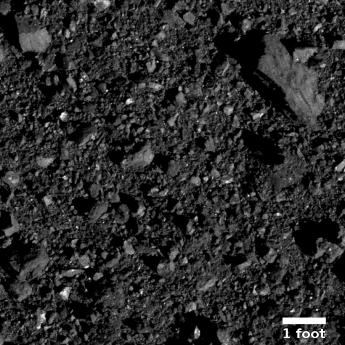
OSIRIS-REx successfully completes touch-and-go rehearsal

OSIRIS-REx yesterday successfully completed its first dress rehearsal of the maneuver that will allow it in August to touch the surface of the asteroid Bennu and grab a sample.

Four hours after departing its 0.6-mile (1-km) safe-home orbit, the spacecraft performed the Checkpoint maneuver at an approximate altitude of 410 feet (125 meters) above Bennu’s surface. From there, the spacecraft continued to descend for another nine minutes on a trajectory toward – but not reaching – the location of the sampling event’s third maneuver, the “Matchpoint” burn. Upon reaching an altitude of approximately 246 ft (75 m) – the closest the spacecraft has ever been to Bennu – OSIRIS-REx performed a back-away burn to complete the rehearsal.

During the rehearsal, the spacecraft successfully deployed its sampling arm, the Touch-And-Go Sample Acquisition Mechanism (TAGSAM), from its folded, parked position out to the sample collection configuration. Additionally, some of the spacecraft’s instruments collected science and navigation images and made spectrometry observations of the sample site, as will occur during the sample collection event.

They plan one more rehearsal, getting even closer to the asteroid, before the August 25 sample grab.

0 comments

Seasonal avalanches in Martian dune gully

Seasonal changes in Martian dune gully
Click for full image.

The science team for the high resolution camera on Mars Reconnaissance Orbiter (MRO) today released a very cool pair of images, taken a Martian year apart, showing some significant changes that had occurred during that time in a large sand dune slope inside a crater. On the right is that pair, reduced and with the top image slightly lightened to bring out the features. As they wrote in the caption,

One large gully in particular has had major changes in every Martian winter since [MRO’s high resolution camera] began monitoring, triggered by the seasonal dry ice frost that accumulates each year.

This time there was an especially large change, depositing a huge mass of sand. The sand divided into many small toes near its end, or perhaps many individual flows descended near the same spot. Additionally, a long sinuous ridge of sand was deposited. This could be a “levee” that formed along one side of a flow, but there is not much sand past the end of the ridge, so it might also be the main body of a flow.

Nor is this dune gully the only active one in this crater, dubbed Matara Crater, located in the southern cratered highlands at about 50 degrees south latitude. If you look at the full image and compare it with an image from 2009 there are many changes across the entire slope field that extends a considerable distance to the north and south of the cropped section shown above.

At this latitude atmospheric carbon dioxide settles as frost during the winter, then sublimates away with the coming of spring. The freeze-sublimation process disturbs the sand each year, causing these avalanches.

4 comments

OSIRIS-REx’s sample grab location on Bennu

Nightingale site on Bennu
Click for full image.

On April 14th engineers for the probe OSIRIS-REx will do the first of two dress rehearsals of their planned touch-and-go sample grab from the asteroid Bennu, presently planned for August 25.

The image to the right was taken on March 3, 2020 from about 1,000 feet away during the spacecraft’s third reconnaissance phase, and is centered on that touch-and-go site, dubbed Nightingale by the science team. It illustrates why that sample grab carries risks that were unexpected. As they point out on the image’s release page, “the rock in the [upper right] of the image is 2 ft (70 cm) long, which is about the length of a small ice chest.” Moreover, across the entire touchdown site are numerous other rocks ranging in size from fists to laptops.

When they designed the mission, they had assumed there would be places on Bennu’s surface made up mostly of dust. areas where such dust would have gathered into ponds, as seen in other asteroids. The expectation also assumed these areas would be larger than any of the smooth areas found on Bennu. As they have noted:
» Read more

0 comments

The icy Phlegra Mountains: Mars’ future second city

Icy glaciers in the Phlegra Mountains of Mars
Click for full image.

About a thousand miles to the west of the candidate landing site for SpaceX’s Starship spacecraft rises a massive mountain wall dubbed the Phlegra Mountains, rising as much as 11,000 feet above the adjacent lowland northern plains.

Phlegra Montes (its official name) is of special interest because of its apparent icy nature. Here practically every photograph taken by any orbiter appears to show immense glacial flows of some kind, with some glaciers coming down canyons and hollows [#1], some filling craters [#2], some forming wide aprons [#3] at the base of mountains and even at the mountains’ highest peaks [#4], and some filling the flats [#5] beyond the mountain foothills.

And then there are the images that show almost all these types of glaciers, plus others [#6]. Today’s cool image above is an example of this. In this one photo we can see filled craters, aprons below peaks, and flows moving down canyons. It is as if a thick layer of ice has partly buried everything up the highest elevations.

None of this has gone unnoticed by scientists. For the past decade they have repeatedly published papers noting these features and their icy appearance, concluding that the Phlegra Mountains are home to ample buried ice. SpaceX even had one image taken here [#3] as a candidate landing site for Starship, though this is clearly not their primary choice at this time.

The map below gives an overview of the mountains, their relationship to the Starship landing site, and the location by number of the images listed above.
» Read more

0 comments

A river canyon on Mars?

Cool image time! In the most recent download of new images from the high resolution camera of Mars Reconnaissance Orbiter (MRO) were two photos, found here and here, that struck me as very intriguing. Both were titled simply as a “Terrain Sample” image, which generally means the picture was taken not because of any specific request by another scientist doing specific research but because the camera team needs to take an image to maintain the camera’s proper temperature, and in doing so they try to time it so that they can do some random exploring as well.

As it turned out, the two images were more than simply random, as they both covered different parts of the same Martian feature, what looks like a branching dry dendritic river drainage. Below is a mosaic of those two images, fit together as one image, with a wider context image to the right, taken by Mars Odyssey, showing the entire drainage plus the surrounding landscape with the white arrow added to help indicate the drainage’s location.
» Read more

0 comments

Changing Mars

The maculae splotch dubbed Maui
For the full images click here (2019) and here (2020).

While Mars appears to be a dead planet, with no clear evidence of life so far discovered, the planet is hardly inactive. Things are changing there continuously, even if it happens at a slower pace than here on Earth.

To the right are two images, rotated, cropped, and reduced to post here, taken by the high resolution camera of Mars Reconnaissance Orbiter. The first was on January 19, 2019, shortly after the end of the global dust storm that engulfed Mars during that Martian year. The second was taken on February 14, 2020, half a Martian year later. Both show one of a string of dark splotches located on the western flanks of the giant volcano Olympus Mons. Scientists call these splotches maculae, and because of their superficial resemblance to the islands of Hawaii, have given them names matching those islands. This particular patch is dubbed Maui. Below is a map showing all the splotches and their position relative to Olympus Mons, taken from a 2019 presentation [pdf].
» Read more

1 comment

Skiing dry ice boulders on Mars

Dune slope, with grooves, in Russell Crater
Click for full image.

Cool image and video time! The image to the right, cropped and reduced to post here, shows something that when I spotted it in reviewing the newest image download from the high resolution camera on Mars Reconnaissance Orbiter (MRO), I found it very baffling. The photo was taken on March 3, 2020, and shows an incredible number of linear groves on the slope of a large dune inside Russell Crater, located in the Martian southern highlands at about 54 degrees south latitude.

If these were created by boulders we should see them at the bottom of each groove. Instead, the grooves generally seem to peter out as if the boulder rolling down the slope had vanished. Making this even more unlikely is that the top of the slope simply does not have sufficient boulders to make all these groves.

The image was requested by Dr. Candice Hansen of the Planetary Science Institute in Tucson, Arizona, who when I emailed her in bafflement she responded like so:
» Read more

3 comments

Enigmas on Mars

Enigmas on Mars
Click for full image.

Cool image time! The photo on the right, cropped and reduced to post here, is a perfect example of the difficulty of explaining the alien landscapes on Mars, based on orbital imagery. It was taken by the high resolution camera of Mars Reconnaissance Orbiter (MRO) on January 23, 2020.

In this one image alone we have the following strange features, all within an area about 8 by 11 miles in size:

  • Several small very obvious pedestal craters (near the top right), some located inside depressions. Pedestal craters are created because the surrounding terrain eroded away around them. Since these are pedestals, however, why are they also inside depressions?
  • Two large circular mesas that appear to vaguely have terraced erosion. These might also be pedestal craters, but maybe not. They also sit much higher than the pedestal craters above. Either way, the mesas remained while the terrain around them eroded away.
  • Several normal craters with a series of circular features within each. At this latitude, 34 degrees south, it is possible these craters are filled with buried ice, what scientists call concentric crater filled glaciers.
  • A light-colored string of ridges aligned to almost look like a kite with tail. The light color says this ridge is not made up of the same material as the circular mesas and pedestal craters, but it too was not eroded away.
  • A number of small bean-shaped depressions (just south of the biggest circular mesa and near the top left). Don’t ask me what caused them. I have no idea.

Overview map

The spot is located in the Martian southern cratered highlands, as shown by the blue cross in the overview map to the right. Complicating its geological history is that it sits inside a very gigantic very old and degraded crater, with numerous newer smaller impacts overlaid on top. Any explanation needs to include these impacts, and the ejecta from them.

If you click on the image and study the full resolution photograph, you can find even more enigmatic features. For most there is a reasonable geological theory. Putting them all in one place and somehow getting all those different explanations to fit together however is far more difficult.

2 comments

Triple impact on Moon

Impact craters Messier and Messier A on the Moon

Cool image time! A new image release from Lunar Reconnaissance Orbiter (LRO) takes a look at the impact process that created the crater Messier and its neighbor crater Messier A. The photo to the right, cropped to post here, shows both craters.

Take a close look at Messier A. It is actually a double crater itself. From the release:

Messier A crater, located in Mare Fecunditatis, presents an interesting puzzle. The main crater is beautifully preserved, with a solidified pond of impact melt resting in its floor. But there is another impact crater beneath and just to the west of Messier A. This more subdued and degraded impact crater clearly formed first.

Did these three craters happen as separate events. According to the data, it appears no. Instead, they might have all been part of a single rain of asteroids, all occurring in seconds.
» Read more

3 comments

In the midst of Mars’ volcano country

lava channel
Click for full image.

Cool image time! While the rest of the world is entirely focused on panic and disease, I am going to go on with my life. The photo to the right, rotated, cropped, and reduced to post here, was taken by the high resolution camera on Mars Reconnaissance Orbiter (MRO) on December 26, 2019. I suspected this channel was lava, and when I asked Colin Dundas of the U.S. Geological Survey’s Astrogeology Science Center in Arizona, he confirmed my suspicion.

Yes, that surface appears to be lava–it is part of the Elysium plains, which have many geologically-young lava flows. It’s likely that the channel is a lava channel, and the surrounding plains may be from an earlier stage of the same eruption.

The entire surface of the channel and the surrounding plains appear very fresh, mostly because of their smoothness and lack of many craters. You can also see what looks like a recent impact (the small dark splotch near the left edge about two-thirds from the top).

The fresh and smooth look of Elysium Planitia generally has led scientists to conclude that much of this region is formed from lava flows, some relatively recently. Thus, this particular lava channel is smack dab in the middle of Mars’ volcano country, quite vast and extensive. The context map below illustrates this.
» Read more

2 comments

Quick fading of a Martian impact crater

Fresh impact crater on Mars, in 2010
Click for full image.

The same impact, four Martian years later.
Click for full image.

Cool image time! Though it seems that no one is really interested in anything but the Wuhan virus and the attempt by our corrupt politicians to use it to gain power, I think that life requires more from us than politics and panic. Thus, I am going to keep posting pure science and cool images.

The two photos to the right were taken by the high resolution camera on Mars Reconnaissance Orbiter (MRO) almost ten years apart. They were both posted as captioned images, the first in 2010, the second on March 19, 2020 to illustrate the remarkable fading of a fresh impact’s dark ejecta, in only about four Martian years.

The March 19, 2020 captioned image included an animation to illustrate the change. I prefer putting the two images side-by-side. Either way, the change is striking. As planetary scientist Alfred McEwen noted in his caption, “the dark material has faded into the background, while the new 6.3-meter diameter crater persists.”

Wind and dust storms probably acted to wipe out the dark material, but the process did not take that long, and last year’s global dust storm was not a major factor, since much of the dark material was already gone in this July 2012 image.

The crater itself is located in Arcadia Planitia, just west of the Erebus Mountains, the very region in the northern lowlands that SpaceX has made its primary candidate landing site for its Starship rocket, partly because the terrain is flat which makes landing easy, and partly because there is amply evidence that these lowlands have lots of ice just below the surface. And the full image for the 2019 photo reinforces this conclusion. Much of the rougher ground south of the impact appears to be the partially sublimated surface of an ice block.

So, while this region will provide an easy smooth landing site and plenty of water for the first human arrivals, those humans will also have to contend with a planet without a thick atmosphere to protect them from most meteorites. Rare as these events are, they happen more often because of Mars’ location closer to the asteroid belt, and they hit the surface far more frequently.

1 comment

Mars: Volcanic, Glacial, or Fluvial?

Sinuous ridge on Mars
Click for full image.

Cool image time! The photograph on the right, rotated, cropped, and reduced to post here, was taken by the high resolution camera on Mars Reconnaissance Orbiter (MRO) on September 30, 2019. It shows what the image title dubs a “sinuous ridge” in a region called Tempe Terra.

What caused it? At first glance the meandering nature of the ridge suggests it was originally a riverbed, formed by flowing water. Eventually the water dried up, and because that riverbed was made of harder material than the surrounding terrain, long term erosion caused that surrounding terrain to wear away, leaving a raised ridge where the river used to be. Scientists have found many such inverted channels on Mars.

Not so fast!
» Read more

0 comments
1 114 115 116 117 118 157