Curiosity looks backwards

Curiosity panorama looking southeast
Click for full resolution version. For original images go here and here.

Overview map
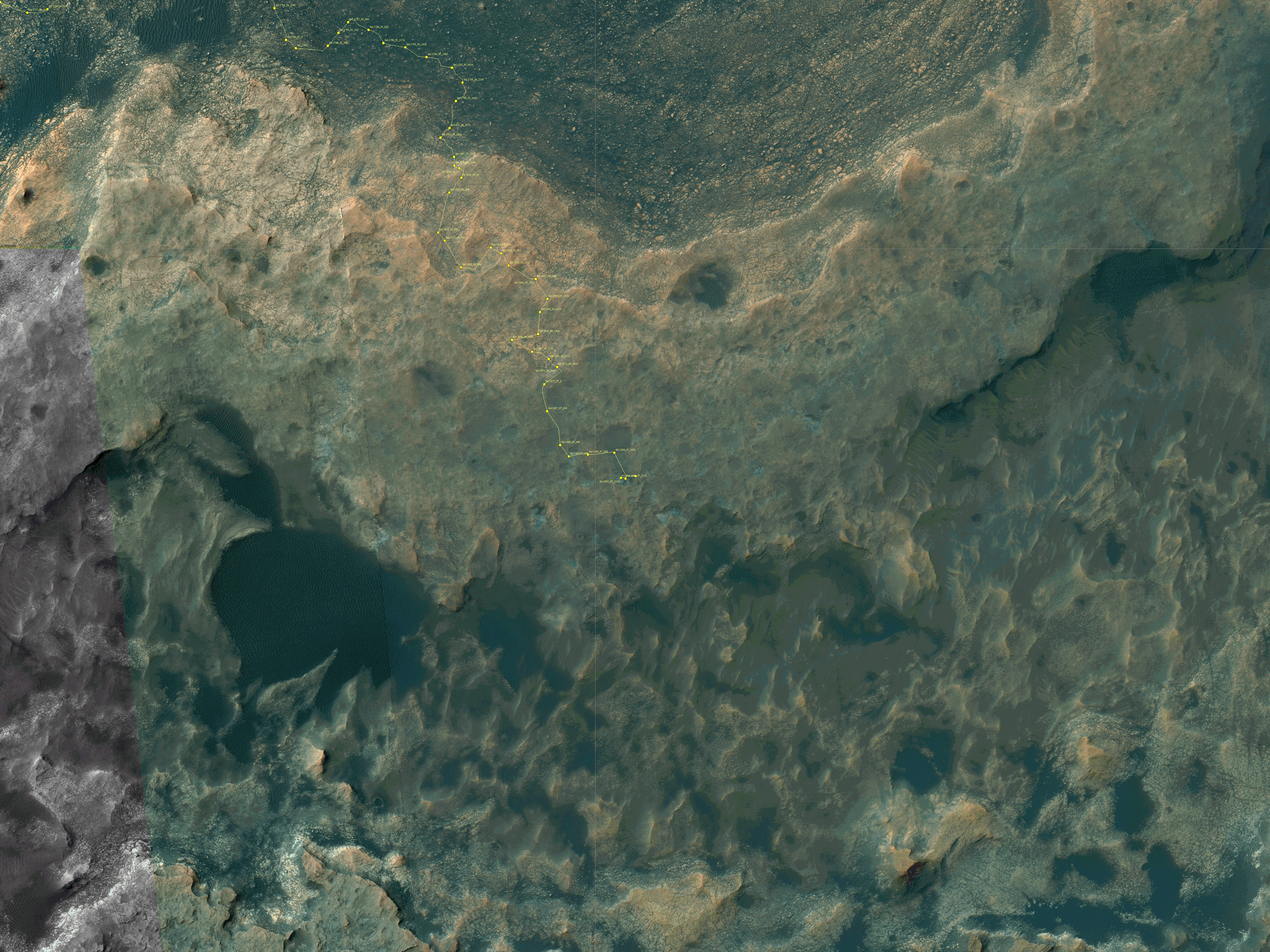
Click for interactive map.

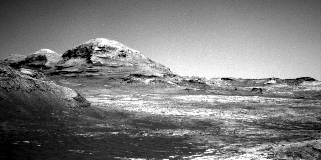
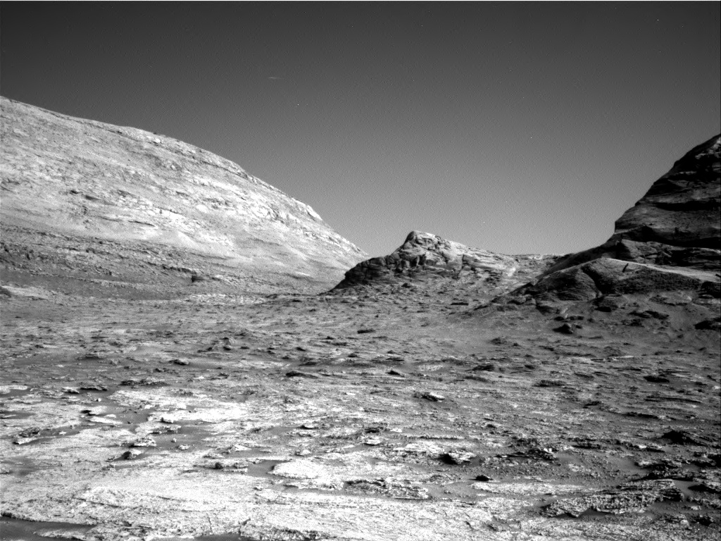
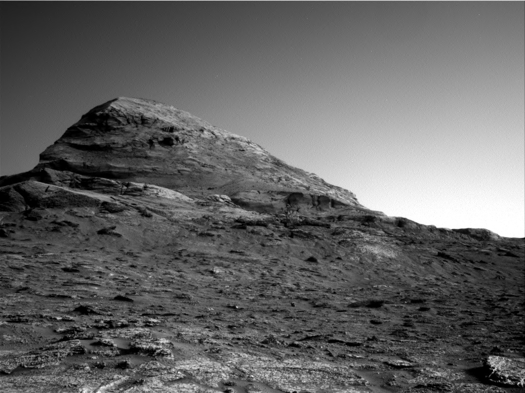
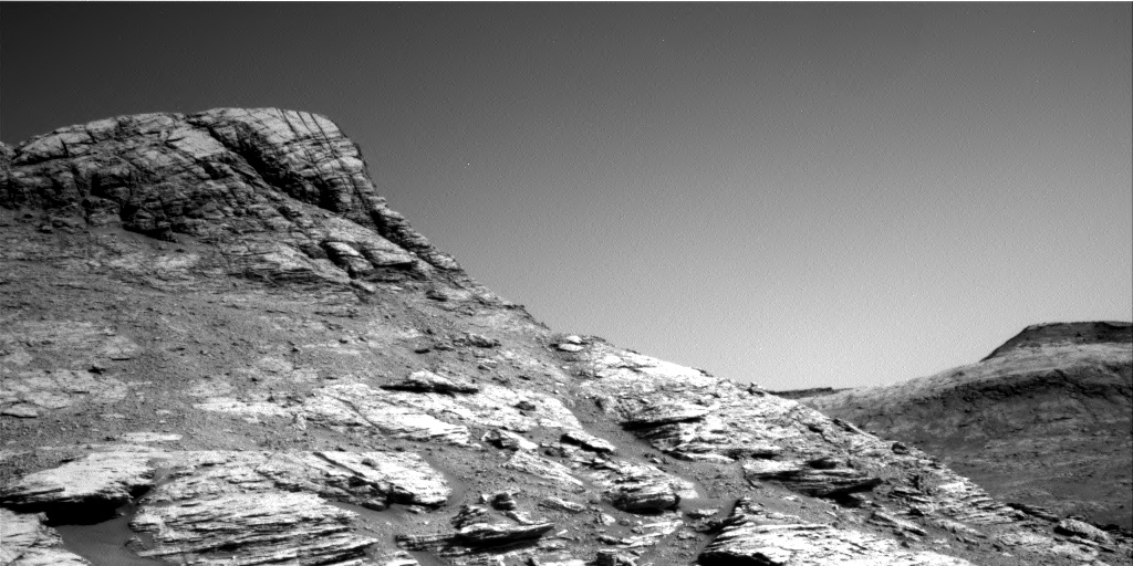
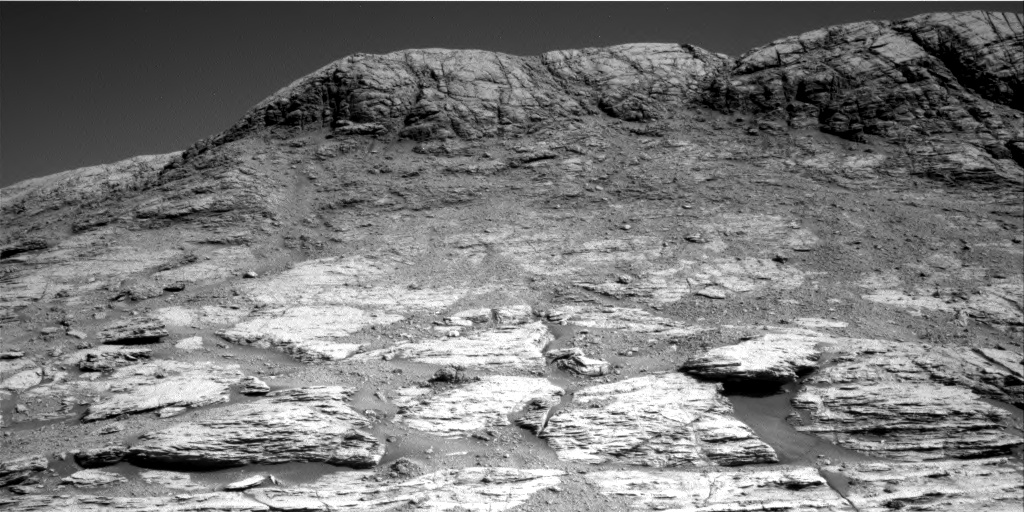
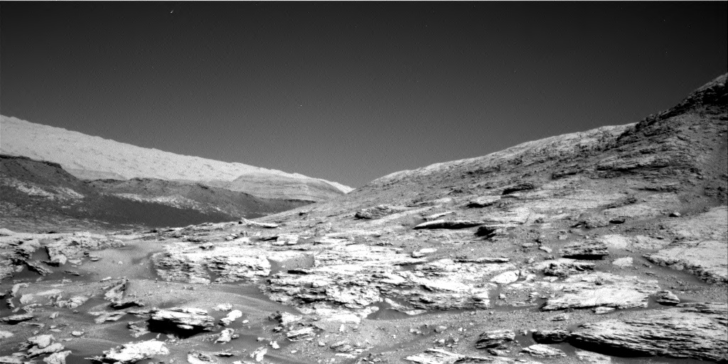
Cool image time! The mosaic above was created from two photos taken on August 13, 2021 by Curiosity’s right navigation camera. It looks to the southeast, at the mountainous Martian terrain that the rover had been traveling just below for the past two months.

The overview map to the right shows with the yellow lines the approximate area covered by this mosaic. The white mountain at the top is the highest visible flank of Mount Sharp, and is beyond the right/bottom edge of the overview map. Mt. Sharp’s peak itself is not visible, as it is higher up and to the right. It is presently blocked by these mountainous foothills.

The science team probably took this image partly to provide another view of these mountains for comparison with earlier views. They can use this new data to look for changes as well as obtain better three-dimensional data.

They also took the image for the same reason I post it here. Having now climbed more than 1,500 feet from the floor of Gale Crater, Curiosity’s view is routinely spectactular. Why not enjoy it?

Mt. Sharp’s peak however is still about 13,000 feet above the rover. The climb up the mountain has just begun.

Curiosity’s mountainous view

Curiosity's view uphill on June 23, 2021
Click for full resolution panorama. Note: Navarro Mt is about 450 feet high.

The travels of Curiosity at the base of Mount Sharp continue. In the past week, since my last update on June 16th, the rover has moved west past the entrance to Gediz Vallis to now sit at the base of Raphael Navarro Mountain, as shown by the panorama above. To get a sense of how far the rover has traveled in the past week, compare this panorama with the one posted then. It is also clear now that they are slowly returning to their planned route, and will not push up into Gediz Vallis as I speculated in that post.

The panorama is created from three photos taken by Curiosity’s navigation camera, found here, here, and here.

The map below the fold gives the context.
» Read more

Curiosity’s dramatic path forward

Curiosity's future travels
Click for full image.

Cool image time! In the coming weeks and months the view from Curiosity is going to give us the most spectacular views of another world since the Apollo astronauts walked on the Moon.

In today’s download of new images from the Mars rover Curiosity was the photo above, reduced to post here. Taken by rover’s right navigation camera, it looks west directly in line with Curiosity’s future travels, and shows that it is now finally entering mountain country.

The overview map below provides the context.
» Read more

The big cliffs of Gediz Vallis on Mars

The Big Cliffs of Mt Sharp
Click for full image.

Cool image time! The photo to the right, cropped and reduced to post here, was taken on May 21, 2021 by Curiosity’s chemistry camera (ChemCam), normally designed to look at high resolution close-up imagery of nearby objects.

However, it can also be used as what the science team call “a long distance spyglass.” The image to the right is an example, looking at what I think are the distant but steadily approaching big cliffs on the western wall of the canyon Gediz Vallis. Make sure you look close at the shadowed cliff-face, probably several hundred feet high. It is filled with huge rock faces reminiscent of the most stark rock cliffs on the mountains of Earth.

The two images below provide the context, which makes the image even more quite breath-taking.
» Read more

Rover update: Curiosity on the move again

After spending more than three months at a single site, drilling three different holes in the same rock, Curiosity is finally on the move again, heading east and uphill toward Mt. Sharp. Yutu-2 meanwhile continues its very slow journey on the far side of the Moon. And the new rovers are halfway to Mars.

Drill holes at Mary Anning site in Gale Crater
Click for full image.

Curiosity

The image to the right, cropped and annotated to post here, shows the three drill holes that scientists had Curiosity drill in this one pavement rock, dubbed Mary Anning and located in the clay unit within Gale Crater on Mars. As I noted in my last update on July 22, 2020, the rover’s science team had made a specific detour in their planned route up Mt. Sharp in order to find this one last place to drill in this geological unit.

Though they have been very quiet about their results, apparently what they found in this one pavement rock was important enough that it required three drill holes. In addition, samples from the second hole were subjected to two of Curiosity’s limited supply of wet chemistry experiments. From the science team’s August 28, 2020 update:
» Read more

Rover update: Curiosity pauses to drill

Curiosity's entire journey so far in Gale Crater

Overview map of Curiosity's recent travels

The artist’s oblique drawing above, as well as the map to the right, provide some context as to Curiosity’s present location and its entire journey in Gale Crater. For the overall context of Curiosity’s travels, see my March 2016 post, Pinpointing Curiosity’s location in Gale Crater. For all rover updates since then through May 2020, go here.

Since my last update on July 7, 2020, Curiosity has quickly moved a considerable distance to the east, as planned, skirting the large sand field to the south in its journey to the best path upward onto Mt. Sharp. The science team however has detoured away from their planned route, shown in red on the map, heading downhill a bit in order to find one last good location in the clay unit to drill. They are at that location now and are presently scouting for the best drilling spot.

About a week ago, before heading downhill, they had stopped to take a set of new images of Curiosity’s wheels. » Read more

Rover update: The state of Curiosity’s wheels

[For the overall context of Curiosity’s travels, see my March 2016 post, Pinpointing Curiosity’s location in Gale Crater. For the updates in 2018 go here. For a full list of updates before February 8, 2018, go here.]

In my last rover update (April 16, 2020), I posted some new images taken of Curiosity’s wheels, showing the damage that they have experienced during the rover’s journey so far in Gale Crater.

At the time, I was unable to match any of the released images, taken on Sol 2732 (April 13, 2020), with the previous wheel image I have used to quickly gauge any new damage (see my July 9, 2019 report).

As it turns out, one of those images did match the earlier image. I simply failed to realize it. Today’s daily download of raw images from Curiosity included additional photos of the rover’s wheels, apparently also taken on Sol 2732 but not available until now. One of those images matches the earlier wheel image, and this time I spotted the match. A comparison is posted below, with my analysis.
» Read more

Curiosity reaches highest point yet on Mars

Curiosity looking north across Gale Crater
Click for full resolution version.

Time for some more cool images! The panorama above, cropped and reduced to post here, was assembled from images taken by Curiosity on March 6, 2020 by its left navigation camera, just after it topped the slope and settled on the very rocky plateau of what the scientists have dubbed the Greenheugh Piedmont, the highest point on Mars that Curiosity has so far traveled. It looks north, across Gale Crater to its far rim, about thirty miles away. That rim rises about a mile higher than where Curiosity sits today.

To quote Michelle Minitti, the planetary geologist who wrote the update describing this achievement:

Kudos to our rover drivers for making it up the steep, sandy slope below the “Greenheugh pediment” (visible in the [right] side of the above image) and delivering us to a stretch of geology we had our eyes on even before we landed in Gale crater!

The panorama below is also assembled from photos taken by the left navigation camera, but this time it looks south, across the piedmont toward Mt. Sharp. Its view of the the piedmont’s very very rough terrain I think proves that once the scientists have gathered their data from this point, the rover will descend back down and resume its original route, circling the piedmont to skirt its southern edge where orbital data suggests the going will be smoother.
» Read more

Mars rover Update: March 4, 2020

Panorama looking south and uphill
Click for full resolution.

Curiosity

[For the overall context of Curiosity’s travels, see my March 2016 post, Pinpointing Curiosity’s location in Gale Crater.

For the updates in 2018 go here. For a full list of updates before February 8, 2018, go here.]

Map of Curiosity's travels

Since my last rover update on January 13, 2020, Curiosity has finally moved on from the base of Western butte, where it spent more than a month drilling a hole and gathering a great deal of geological data. Rather than head downhill and around the plateau and back to its planned route (as indicated by the red line in the map to the right), the Curiosity science team decided to push upward and onto the Greenheugh Piedmont (as indicated by the yellow line).

They had always planned to reach the top of this plateau, but not for several years. First they were going to head east to study a recurring slope lineae (see my October 2019 update), an example of a dark streak that darkens and fades seasonally and could provide evidence of water seepage from below ground.

Instead, they decided the close proximity of the top of the piedmont and its geology was too tempting. The piedmont is apparently made up of a layer that is very structurally weak, and breaks up easily, as you can see by the panorama above. It also appears to sit on softer, more easily eroded material, which thus accentuates this break up. If you look at the left part of the panorama you can see what I mean. The piedmont layer there is the thin unbroken layer sitting on what looks like sand. As that sand erodes away the layer quickly breaks into small pieces, as shown in the rest of panorama.

Traveling on the piedmont will likely be difficult and threaten Curiosity’s wheels. I suspect this reality prompted them to choose to get to the top and obtain data now, rather than wait several more years of rough travel that might have made access to the piedmont difficult if not impossible.

They presently sit just below the top, and are studying their options before making that last push.
» Read more

Sightseeing Central Butte on Mars

Central Butte in foothills of Mt Sharp

Overview showing perspective of panorama

Curiosity has now roved to the very foot of Central Butte, where it has been taking close-up and panorama images of the butte and its geological layers. The panorama above was created from three Curiosity navigation images taken on Sol 2577 (November 6, 2019), here, here, and here.

The overview on the right, based on Curiosity’s position about ten sols ago slightly farther from the butte, still indicates roughly with the yellow lines the area photographed in this panorama. The dotted red line indicates Curiosity’s initial planned route.

Following that route Curiosity will eventually climb up onto the plateau beyond this butte, approaching that higher terrain farther to the west. Once they do, however, they will no longer have access to the geological layers below the surface. Central Butte gives them a window into those layers, which is why they are going to spend some time at this location, first by taking a few sols looking at the butte at this point, then circling around to study its back side.

Curiosity science team to attempt first drilling in a year

After a year of tests and engineering rethinking, the Curiosity science team has decided to attempt drilling its first hole in more than a year.

From yesterday’s Curiosity mission update:

Because there is only so much data volume and rover power to go around, performing drill activities must temporarily come at the expense of scientific investigations (although you’d be pressed to find a disappointed science team member this week, as the drilling campaign will bring loads of new scientific data!). As a result, with the exception of some environmental observations by the Rover Environmental Monitoring Station (REMS) instrument, today’s plan does not have any targeted scientific observations within it. Today will instead be dedicated to drill preload activities and imaging for engineering and rover planning purposes in preparation for a full test of the revised drilling operations.

The problem with the drill has been its feed mechanism, the equipment that moves the drill downward into the hole. As designed the robot arm would get planted on the surface to provide stability for the drill, which as it drilled would be pushed downward that that feed mechanism. Last year they found something had clogged that mechanism so that it would not retract properly.

From what I understand, what they have tested and have decided to try instead is to place the drill against the surface in an extended position, and use the arm itself to push the bit downward. The concern is whether the arm can hold the drill steady. They have done some tests and think it can. We shall soon find out.

Curiosity takes a panorama that shows its entire journey so far

Cool image time! The Curiosity science team has released a panorama taken in October 2017 that looks north across the floor of Gale Crater and shows the rover’s entire journey since it landed in 2012.

Rather than post the image here, I have posted below the fold a video produced by the science team that pans across the entire panorama, and then shows where Curiosity has traveled in that panorama. Look close, and you will realize how truly little of Mars we have so far explored.
» Read more

Mars rover update: December 18, 2017

Summary: The scientists and engineers of both Curiosity and Opportunity have route decisions to make.

Curiosity

null

For the overall context of Curiosity’s travels, see Pinpointing Curiosity’s location in Gale Crater.

Since my November 16 update, Curiosity’s travels crossing Vera Rubin Ridge, a geological bedding plain dubbed the Hematite Unit, has continued apace. They however have not been following the route that had been planned beforehand, as shown by the yellow dotted line on the right. Instead, they have headed south, along the red dotted line. For the past week or so they have been doing a variety of research tasks in the same area, analyzing samples taken months before, studying sand deposits, and taking many images of some interesting rock layers.

I also suspect that the lack of movement in the past week is partly because they need to make some route-finding decisions. The planned yellow route shown above appears to be somewhat rough in the full resolution orbital image. While I suspect they will still head in that direction, I also think they are doing some very careful analysis of this route and beyond, to make sure they will not end up in a cul de sac where the rover will not be able to continue its climb of Mount Sharp.

Opportunity

For the context of Opportunity’s recent travels along the rim of Endeavour Crater, see my May 15, 2017 rover update.
» Read more

Mars rover update: August 11, 2017

Summary: After a two week hiatus because the Sun was between the Earth and Mars and blocking communications, both rovers are once again on the move.

Curiosity

For the overall context of Curiosity’s travels, see Pinpointing Curiosity’s location in Gale Crater.

Curiosity panorama, Sol 1782

Vera Rubin Ridge close-up

Since my last update on July 12,, Curiosity spent most of the month waiting out the solar conjunction that placed the Sun between the Earth and Mars and blocked communications. In the past few days, however, the rover has begun to send down images again while resuming its journey up Mt. Sharp. The panorama above, reduced to show here, was taken by the rover’s left navigation camera, and shows the mountain, the ridge, and the route the rover will take to circle around the steepest sections to get up onto the ridge. To see the full resolution panorama click on the picture.

To the right is a full resolution section of the area in the white box. As you can see, the geology of the ridge is many-layered, with numerous vertical seams or cracks. In order to track the geological changes across these layers as the rover climbs, the science team is as expected taking a systematic approach.

Lately, one of our biggest science objectives is to conduct bedrock APXS measurements with every 5-meter climb in elevation. This allows us to systematically analyze geochemical changes in the Murray formation as we continue to climb Mount Sharp. Yesterday’s drive brought us 6 meters higher in elevation, so another touch and go for today it is!

Below is a cropped and reduced resolution image of the most recent orbital traverse image, dated sol 1754. The dotted line shows where I think the rover’s has traveled in the last 28 sols. I have also annotated what I think is the point of view of the panorama above.
» Read more

Mars rover update: June 23, 2017

Summary: Curiosity continues up hill. Opportunity has wheel problems.

Curiosity

For the overall context of Curiosity’s travels, see Pinpointing Curiosity’s location in Gale Crater.

The march up Mt Sharp continues. Since my last update on May 15, Curiosity has continued working its way up towards what the science team has named Vera Rubin Ridge, the beginning of a lighter, yellowish layer of rock, dubbed the Hematite Unit, that sits higher up the mountain’s slope. They have been traveling on the Murray Formation now for more than a year, since March, 2016, so entering this new layer of geology is eagerly anticipated by the science team. (This October 3, 2016 press release. gives an overall picture of the geology Curiosity is traversing.)

Reader Phil Veerkamp sent me a beautiful panorama he stitched together from recent Curiosity images of Vera Rubin Ridge, directly to the south of the rover and higher up hill. Below is a reduced resolution version. Be sure you click on it to explore the full resolution image. This is a new type of terrain, significantly different than anything Curiosity has seen up to now. It also appears that the rover will see far less dust, and might be traveling mostly over solid boulders. Below I have cropped out a very small section of the ridge line near the center of the full image, just to illustrate this.
» Read more

Mars rover update: January 18, 2017

Curiosity

Curiosity's location, Sol 1582

For the overall context of Curiosity’s travels, see Pinpointing Curiosity’s location in Gale Crater.

In the past month, since my last rover update on December 22, 2016, Curiosity has begun moving again, carefully picking its way through the dune-filled flats in the foothills at the base of Mount Sharp. The route taken, shown on the image on the right, corresponds to the easternmost of the possible routes I noted in my November 14, 2016 update. This route is also the most direct route, which I think is smart considering that the rover’s life on Mars certainly uncertain and the higher they can climb the more geological information they will get.

I have also annotated the likely route into the near future, including a possible side trip to the base of the mesa up ahead. It appears to me that they are now a little more than halfway through the flats, with Mt. Sharp directly ahead, as shown by the panorama below, taken near the end of December. The goal is a canyon just out of view to the right of this panorama.

Looking at Mount Sharp

The flats the rover is presently traversing, and visible in the foreground of the panorama above, is strewn with dark sand that often piled into large sand dunes. Where the ground is exposed, it is made up of a scattering of pavement-like rocks. As noted in a press release yesterday, many of these flat rocks have polygonal cracks and boxwork similar to that seen in dried mud here on Earth, suggesting that this area was once wet and then dried. This geology helps confirm the theory of planetary scientists that Gale Crater was once filled with water that slowly evaporated away. As the rover climbs, it leaves the lakebed and begins to move through the lake’s various shores, each one older than the last.

Opportunity

For the overall context of Opportunity’s travels at Endeavour Crater, see Opportunity’s future travels on Mars.
» Read more

Curiosity heads for the dunes

Bagnold Dunes

The Curiosity science team has decided to send the rover towards some large active dunes, visible in its journey ahead up Mt. Sharp.

On its way to higher layers of the mountain where it is investigating how Mars’ environment changed billions of years ago, NASA’s Curiosity Mars rover will take advantage of a chance to study some modern Martian activity at mobile sand dunes.

In the next few days, the rover will get its first close-up look at these dark dunes, called the “Bagnold Dunes,” which skirt the northwestern flank of Mount Sharp. No Mars rover has previously visited a sand dune, as opposed to smaller sand ripples or drifts. One dune Curiosity will investigate is as tall as a two-story building and as broad as a football field. The Bagnold Dunes are active: Images from orbit indicate some of them are migrating as much as about 3 feet (1 meter) per Earth year. No active dunes have been visited anywhere in the solar system besides Earth.

In the image on the right the target dune is in the center beyond the dark ridge line in the foreground. It looks kind of like a pointed mesa. the dark sandy area on the center right just below the dark ridge line in the center of the image. (Newer images released today gave me a more correct idea of the dunes as shown in this image.) Click here to see the full image. The rover is presently about 200 yards from the first dune, and should reach it in the next few days.

Curiosity looks ahead at its future travels

The future terrain at Mt Sharp

Cool image time! The above image is a cropped version of a full resolution image taken by Curiosity of the terrain the rover will be traveling in the coming years.

I have also enhanced the contrast slightly to bring out the details. The terrain is rugged and very diverse, from rounded buttes to rocky outcrops.

Gravel and sand ripples fill the foreground [not shown in my cropped version above], typical of terrains that Curiosity traversed to reach Mount Sharp from its landing site. Outcrops in the midfield are of two types: dust-covered, smooth bedrock that forms the base of the mountain, and sandstone ridges that shed boulders as they erode. Rounded buttes in the distance contain sulfate minerals, perhaps indicating a change in the availability of water when they formed. Some of the layering patterns on higher levels of Mount Sharp in the background are tilted at different angles than others, evidence of complicated relationships still to be deciphered.

Traversing this rugged terrain will be a challenge but it is necessary to obtain data that will help decipher its origins. The immediate goal will be to reach the light brown terrain in the distance. In the full image, that region gently slopes upward to the left to the mountain summit, providing a route to the rover’s eventual goal.

Curiosity to begin climbing

Scientists have decided to begin Curiosity’s climb of Mount Sharp immediately rather than continue a planned traverse along the base of the mountain prior to heading uphill.

Curiosity’s trek up the mountain will begin with an examination of the mountain’s lower slopes. The rover is starting this process at an entry point near an outcrop called Pahrump Hills, rather than continuing on to the previously-planned, further entry point known as Murray Buttes. Both entry points lay along a boundary where the southern base layer of the mountain meets crater-floor deposits washed down from the crater’s northern rim.

The issues with Curiosity’s wheels also played a part in this decision.

Images from Curiosity have spotted some unexpected geology in Gale Crater.

Images from Curiosity have spotted some unexpected geology in Gale Crater.

A mosaic of high-definition images of Mount Sharp, the central peak dominating the landing site at Gale Crater, reveals tilted strata never before seen on Mars. The strata dip downwards at an angle close to that of the slope of the foothills of the 18,000-ft. tall mountain within which they are formed.

“The cool thing is the cameras have discovered something we were unaware of,” says mission chief scientist John Grotzinger. “This thing jumped out at us as being very different to what we expected,” he adds. Lying in the low-lying foothills beyond the dune field between the rover and the base of Mount Sharp, the inclined layers are a “spectacular feature” that could not be seen from orbit.

I think there are two reasons these tilted layers are puzzling scientists.
» Read more

NASA scientists in a battle with astronomers over who gets to name things on Vesta and Mars.

A rose by any other name: NASA scientists are in a battle with astronomers over who gets to name things on Vesta and Mars.

This is not a new problem. The International Astronomical Union (IAU) has maintained its power over naming everything in space since the 1960s, even though the IAU has sometimes ignored the wishes of the actual discoverers and explorers and given names to things that no one likes. For example, even though the Apollo 8 astronauts wanted to give certain unnamed features on the Moon specific names, the IAU refused to accept their choices, even though those astronauts were the first human beings to reach another world and see these features up close.

Eventually, the spacefarers of the future are going to tell the IAU where to go. And that will begin to happen when those spacefarers simply refuse to use the names the IAU assigns.