More hatred and bigotry from the left

It has become quite depressing to repeatedly document the numerous daily examples of leftist hatred and bigotry that now populate American intellectual and political culture. It must be done, however, so below are a few more recent examples from the past month, categorized appropriately. A quick scan of the stories will illustrate to anyone how bankrupt our modern intellectual and political culture has become. Worse, it appears with time that the levels of emotional hate and bigotry are only growing.

First the bigotry:

I could list more, but these are enough. They illustrate the bigoted focus of the left. To them, everything is race or ethnicity. You cannot accomplish anything as an individual if you are a minority, and all your failures can be blamed on the evils of the white race. More important, it is their right to oppress whites, merely because they perceive that some white cultures in the past were oppressive. Under this mentality, we shall soon see the return of segregation (as indicated by at least two stories above) and racial discrimination. And it won’t matter that this time it will be whites who are oppressed instead of blacks. It will still be evil, because it will be based not on the content of each individual’s character but on the color of their skin.

Next the hate:
» Read more

How I spent my Saturday: Removing graffiti in a cave

Yesterday was another of my many cave adventures, but different than most. Instead of exploring and mapping newly discovered or out-of-the-way remote cave passages, I participated in a project of the Central Arizona Grotto (a chapter of the National Speleological Society and located in Phoenix) to remove years of graffiti from Peppersauce Cave. You can see pictures of yesterday’s effort here, published by the Arizona Star.

You won’t see any pictures of me. The younger cavers were far more photogenic.

Peppersauce has become what cavers call a “sacrificial cave.” It is open and ungated, relatively easy to traverse, and very well known throughout the state. Thus, many inexperienced people go there to see it, most of whom know little about caving, the ethics of protecting them, or the proper techniques for caving safely. Yesterday, while we were working to either sand-blast, chemically remove, or grind away old spray-paint (some of which was sadly obscene), I must have seen between 150 to 200 people go by. At least two thirds of them were not wearing helmets. Many clearly had never been in a cave before. Some were not wearing headlamps, carrying flashlights instead (which makes climbing harder because you don’t have use of both hands and can easily lose your light). A few even came in with no lights, depending instead on the lights their companions carried.

Because of this heavy traffic, Peppersauce has been badly trashed. On visits by experienced cavers we routinely carry out bags of trash, only to find that trash reappearing, sometime in mere hours. The walls of the cave had been covered with graffiti, some many layers deep.

Ray Keeler of Central Arizona Grotto (CAG) has organized several projects in the past to remove this graffitti over the past two decades. The effort he is leading this year is the third, and has the help of cavers from grottos throughout the state. This was the fourth clean-up weekend, and the first that I was able to attend (having missed the first three due to scheduling conflicts).

I’ve done similar things before, but never on this scale. It was quite educational using the solvent to remove some graffiti, but unfortunately many types of paint are completely resistant to removal by either sand-blasting or solvent. After awhile I got discouraged doing solvent work. Too often nothing got removed. In the afternoon I switched to our last technique, grinding, and was far more gratified with the results. The grinder, which we do not use on formations, removes only the slightest layer of material, and thus does little damage. It however is very effective in removing all paint, no matter how resistant.

The cave is now about two thirds cleaned. We are racing to finish the rest before the summer, because a typically insane reason forced upon us by the government. You see, according to a law passed by Congress, graffiti that is more than fifty years old is considered historical, and cannot be removed without a great deal of paperwork and complex bureaucracy. Spray paint was invented in the late 1960s (about fifty years ago), and so some of this ugly graffiti, no matter how obscene, is going to be protected by our government beginning later this year. Our goal is to get it removed beforehand, so that the cave can be returned to a more natural state, for future visitors to experience.

The first sunspots of the next solar cycle

In linking to my sunspot update this week, there has been a lot of speculation at the climate website WattsUpWithThat that the next solar cycle has begun.

Our resident solar physicist, Dr. Leif Svalgaard commented and provided a link to something reported by his colleagues, something that likely would not have been possible without the fantastic solar observations of NASA’s Solar Dynamic Observeratory (SDO). He said: “Cycle 25 has already begun. It looks to me that SC25 will be a bit stronger than SC24, so probably no Grand Minimum this time.” It seems a small sunspot has been observed, that has the opposite polarity of cycle 24 sunspots. [emphasis in original]

The speculation at WattsUpWithThat, which suggested that this sunspot was the first such sunspot this cycle, was not quite accurate however. This sunspot with an opposite polarity, which decayed so quickly that it did not rate getting a sunspot number, was not the first. This week the Solar-Terrestrial Centre of Excellence, a Belgian organization focused on space-solar science, published this very good article discussing not only this sunspot but two others, one of which occurred more than a year ago.
» Read more

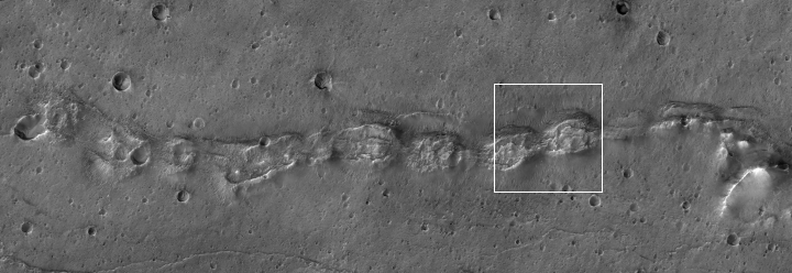
A Martian snake of collapsed hills

A Martian snake of collapsed hills

Close-up of collapsed hills

Time to once again delve into this month’s release of high resolution images from Mars Reconnaissance Orbiter. The image above, cropped, rotated, and reduced in resolution to post here, shows a string of strange mounds or hills, each with similar collapse features on their tops. If you click on the picture, you can see the full resolution image, rotated properly with north up. You can also go to the MRO post, which provides some additional information.

The white box indicates the location of the cropped close-up, at full resolution, to the right. This area is typical across the entire snake-like ridge. You have these mounds or hills, each with chaotic depressions at their tops. The depressions suggest that this ridge follows an underground void, like a lava tube. The ridge-like nature of the line of hills also suggest that this tube has been exposed by erosion over time, with the surrounding terrain more easily blown or washed away while the more resistant ridge remains.

At the same time, the line of hills is baffling. Why would a lava tube expand periodically to form something that looks like a string of pearls?

The location of this snaking ridge provides some additional context.
» Read more

Sunspot update for March 2018: the sun crashes!

It surely looks like the solar minimum has arrived, and it has done so far earlier than expected! On Sunday NOAA posted its monthly update of the solar cycle, covering sunspot activity for March 2018. Below is my annotated version of that graph.

March 2018 was the least active month for sunspots since the middle of 2009, almost nine years ago. In fact, activity in the past few months has been so low it matches the low activity seen in late 2007 and early 2008, ten years ago when the last solar minimum began and indicated by the yellow line that I have added to the graph below. If the solar minimum has actually arrived now, this would make this cycle only ten years long, one of the shortest solar cycles on record. More important, it is a weak cycle. In the past, all short cycles were active cycles. This is the first time we have seen a short and weak cycle since scientists began tracking the solar cycle in the 1700s, following the last grand minimum in the 1600s when there were almost no sunspots.
» Read more

“If you have wrongthink, you will not be allowed.”

The fascist, intolerant, and oppressive nature of today’s leftist culture has now gotten so bad that The Atlantic, a liberal publication long considered a reasonable intellectual voice from the left, can no longer tolerate for more than two weeks the hiring of a conservative, even though that conservative, Kevin Williamson, was also a vehement opponent of Donald Trump.

The quote that forms the title of this essay however comes not from the above Williamson story, but from a cogent essay by Ben Domenech, publisher of The Federalist about that intolerant leftist culture. As he says,

This story [Williamson’s firing] is a predictable continuation of the left’s ownership not just of media but indeed of all institutions. It is depressing. It is predictable. And it is where we are as a country now. It is not confined to the realm of ideas. Eich, Damore, Williamson and others are subject to blacklists and HR reports and firing in every arena of industry and culture. If you have wrongthink, you will not be allowed for long to make your living within any space the left has determined they own – first the academy, then the media, then corporate America, and now the public square. You will bake the cake, you will use the proper pronoun, and you will never say that what Planned Parenthood does is murder for hire, and should be punished as such under the law.

As Domenech notes, Williamson’s firing is only one example of a legion of similar stories. There is the fascist intolerance of modern academia for example. Or we can talk about the hateful scapegoating of innocent NRA members, blaming them for a murderer’s violence merely because they wish to defend their Constitutional rights as specifically outlined in the Bill of Rights.

Or maybe we should mention the hate and violence committed against children and students, merely because they either wear a “Make America Great Again” t-shirt or carry signs supporting Trump.

I wish these were only isolated examples. They are not. For most of the second half of last year I was able to post weekly updates listing anywhere from six to several dozen new stories describing this hateful leftist culture. Here are just a few more that I gathered in mid-March but found too depressing to report at the time:
» Read more

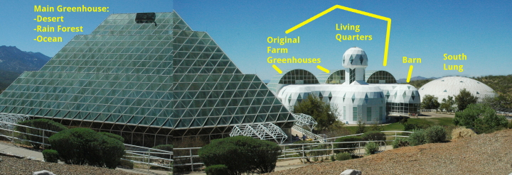
Revisiting Biosphere 2

Biosphere 2

This week Diane and I have a friend visiting from back east. As locals generally do when guests visit, we used this visit as an excuse to go sightseeing at local attractions that we somehow never got the time to visit on our own.

So on Tuesday we drove north to take a tour of Biosphere 2, what has been called “a giant space-age ark in the middle of the desert.” The idea, as sold heavily to the public when it was built in the late 1980s and early 1990s, was that eight people would try to live in a closed system for two years, demonstrating the technology needed to both build colonies on other worlds as well as protect the environment here on Earth.

The system wasn’t really closed however (power came from outside), and during the first two year mission it seemed they were somewhat lax about keeping the system closed.

One Biospherian accidentally cut off the tip of her finger and left for medical care. When she returned, she carried in two duffle bags of supplies to the supposedly self-sustaining environment (which presumably would not have been feasible on, say, Mars).

There were also financial issues, as mentioned by our tour guide and confirmed by news stories. Its backer, Texas oil man Edward Bass, spent somewhere between $150 to $200 million. It seems however that the managers running Biosphere 2 didn’t keep good books, and when Bass asked for an accounting they couldn’t provide it. Instead, they attempted to sabotage the project’s second mission.
» Read more

A spray of volcanic ejecta on Mars?

pit features on floor of crater

Time for some more weird Mars geology! Today the science team for the high resolution camera on Mars Reconnaissance Orbiter released its monthly batch of new images. There is a lot of interesting stuff buried therein, some of which I will feature periodically in the next month.

The image on the right, reduced in resolution to post here, is a good example. (If you click on the image you can see the full resolution version.) It shows a scattering of pits in three specific areas on the crater floor, all in a line going from the northeast to the southwest. Yet, the rest of the crater floor lacks similar pits, and is either very smooth or has a mottled appearance. Both the smooth and the mottled areas appear to have a very faint trend going from the northwest to the southeast, which to my eye appears caused by the general wind direction that flows across the crater floor.

Even more intriguing, the pits in these three areas appear to be mostly oblong and also trend from the northeast to the southwest, cutting across the general trend of the rest of the crater floor. You can see this in the cropped closeups from the full resolution image below, showing the two boxed areas indicated on the image on the right.
» Read more

Near the Martian shoreline

One of the prime areas of research for Mars planetary geologists is the region on Mars where the geography appears to transition from the southern cratered, rough terrain to the northern low, generally smooth, and flat plains. It is theorized by some scientists that the northern plains were once an ocean, probably shallow and probably intermittent, but wet nonetheless for considerable periods. The global map of Mars below, created by the laser altimeter on Mars Global Surveyor, clearly shows the obvious elevation differences between the low northern plans (blue) and the high, more cratered southern regions (changing from yellow to orange as you move higher).

Labeled global Map of Mars

Scientists have spent a considerable effort studying this transition zone (green on the map), illustrated by just one example I recently highlighted, showing that, though there does not appear to be a clear shoreline in many places, there is strong evidence that a shallow ocean repeatedly rose and fell in this transition zone, leaving behind geological ripple marks vaguely reminiscent of those seen on a beach caused by the rise and fall of the tides.

Today we highlight another example, taken in January 2018 at the location indicated by the cross on the above map.
» Read more

The James Webb Telescope: a signpost for identifying fake news sources

The news yesterday that NASA will once again have to delay the launch of the James Webb Space Telescope due to a variety of technical issues and management errors not only exemplified the fundamental failure of the federal government, it also illustrated the routine failures of today’s mainstream press.

First, Webb’s new delay epitomizes the systemic incompetence of Washington. Despite being 13 years behind schedule and costing eight times more than originally planned, NASA and its contractors still couldn’t get things right.

Most of the problems have occurred with the spacecraft half of the project, which was built by Northrop Grumman in California and is undergoing testing there. During the teleconference, NASA officials, including acting Administrator Robert Lightfoot, expanded upon technical problems first reported publicly by the agency’s inspector general last month.

These include leaky valves within the spacecraft’s propulsion system and difficulties encountered during deployment tests of the sun shield. Not only did the thin, five-layer sun shield snag during the deployment, but technicians also found seven tears up to 10cm long within the material. NASA and Northrop Grumman have identified fixes for these problems, but their repair has added months of delays to the project, and engineers cannot be sure that more issues will not crop up during further testing.

Such failures, in NASA and in all big federal projects in recent years, are hardly news. Only the willfully blind or those who support wasting tax dollars to distribute pork will deny they exist.

The failures of the federal government however is not the focus of this essay. Instead, the announcement yesterday and the coverage of it by the press provides us a perfect and very obvious signpost for differentiating between the fake news sources that are generally unreliable or too often allow their biases to influence their reporting, and those sources that do a good job.

That signpost is one simple fact: Webb is not a replacement or successor to the Hubble Space Telescope, despite NASA making this false claim for decades. Hubble is an optical telescope. Webb will view the universe in the infrared. These are too entirely different things.

Yet, too many news sources today repeated NASA’s false claim, illustrating how little they know about both telescopes and their design, while revealing their complete inability to do some basic journalistic research. Instead they merely rewrite old press releases, and thus prove clearly by their bad reporting why so many people have so little respect for the modern press.

The worst examples made this false claim right in the headline:
» Read more

Mars rover update: March 21, 2018

Summary: Curiosity continues its exploration of Vera Rubin Ridge, including several drilling attempts. Opportunity is halfway down Perseverance Valley.

For a complete list of all past updates going back to July 2016, see my February 8, 2018 update.

Curiosity

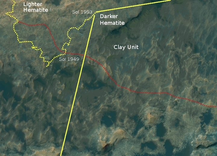
Curiosity's traverse map, Sol 1993

For the overall context of Curiosity’s travels, see Pinpointing Curiosity’s location in Gale Crater.

Since my February 8, 2018 update, the Curiosity science team has apparently been loath to leave Vera Rubin Ridge. They had begun the trek to the northeast that would take them towards the exit ridge heading to the southeast, as indicated by the dotted red line on the traverse map above, but then continued past that planned route to continue to the northeast. Along the way they attempted to drill twice using an improvised approach that they hoped would bypass the drill’s stuck feed mechanism, without apparent success.

The panorama below is looking to the west and south, as indicated by the yellow lines in the image above.
» Read more

This week in leftist fascism

It is only a week since my last report on leftist fascism and bigotry. Yet, in that short week the number of new examples of violence, intolerance, bigotry, and hate coming from liberal and leftwing activists is almost more than I can keep up with. Below is a small sampling, all from the period from March 6 to March 12:

This week’s stories highlight three themes that clearly dominate today’s leftist activist movement of outrage. First, there is the use of violence and mob action to attack things they don’t agree with or dislike, as illustrated in the first two stories. If you click on the link to the Jordan Peterson speech, you can see some video of these demonstrators. It is not pretty.

Videos of the protest, taken by protestors themselves, don’t paint the leftists in a good light. In the video below an exit door is barricaded as one protestor shouts, “Lock ’em in and burn it down!”

The second theme is that of bigotry and race hatred. This leftwing movement clearly hates Jews and whites, and is trying to institutionalize that bigotry so that it becomes acceptable to marginalize and oppress individuals of those groups, merely because of their race or religion. Consider for example the program instituted by Evanston public school district from the fourth link above:
» Read more

Martian craters go splat!

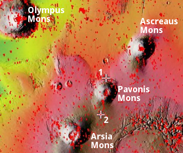
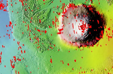
Overview of the volcanic Tharsis Bulge on Mars

Cool image time! In continuing my exploration of this month’s Mars Reconnaissance Orbiter (MRO) image release, I found two interesting images of small craters, one as part of that image release, the other found completely by accident.

The map on the right, taken from the MRO HiRISE archive page, shows the locations of these two images. Both are located in the lava plains that surround the giant volcano Pavonis Mons, the central volcano of the three volcanoes to the east of Olympus Mons. Previously, I have done posts focusing specifically on both Pavonis Mons and Arsia Mons. Not only is the geology of these gigantic volcanoes fascinating, there is evidence that ancient glacial ice lurks in lava tubes on their slopes, making them potentially prime real estate for future explorers.

The first image, labeled #1 on the image above, was taken in January 2018 to get a better look at a small crater on the surrounding lava plains, and was part of the MRO March image release. I have cropped it to post here, focusing on the crater itself.

My first reaction on seeing the image was, “Did this impact not go splat when it hit?”
» Read more

Leftist fascism at the start of 2018

Beginning in October 2017, I began to do weekly posts listing the free speech atrocities that were occurring on American campuses. I finished the year with a summary which listed all the colleges where such tyranny appeared to be supported and encouraged. As I noted,

[A]lmost every college shown marks a moment when leftist members of an administration, facility, or student body acted to squelch the free speech rights of a conservative. Nor do I think this is because of bias on my part. From the beginning I have recognized the possibility that I might unfairly only report oppressive incidents committed by the left, and have tried to avoid that. Unfortunately, despite my sincere effort to report incidents where conservatives tried to silence liberals, during the whole year I only came across one event where a conservative college acted to shut down a dissenting liberal speaker. I admit that I might have missed a few, but even if I did I do not think this would change the overall pattern. 2017 was a year in which the left decided that it was acceptable to act like fascist thugs and do whatever they could to shut down the free speech of opposing points of view.

I have been lax posting these weekly reports since the beginning of 2018, and this post is my attempt to catch up. Interesting, I got inspired to do this by a story that isn’t directly related to academic fascism at all: Christian Bridal Shop Closes Down Over Fear of LGBT Law After Facing Death Threats.

The local government there is about to pass an ordinance that will make it illegal for these dressmakers to both practice their religion while also making wedding dresses. Rather than violate their conscience, they are shutting down. Worse however was the level of hate directed at them simply because they do not support same-sex marriage:

Because of the store’s refusal to sell dresses for same-sex weddings, Boucher and her family have faced a variety of different threats through social media, email and telephone since 2014. People have not only threatened to burn down their place of business but have also threatened to shoot them in the head. Last summer, the shop closed down temporarily to the public and was only accepting appointments because the harassment got so bad.

Much like the early days of Christianity in the Roman empire, faithful Christians are now finding that they must go underground to practice their faith in America.

It is for this reason that the title of this post uses the term “leftist fascism,” not “academic fascism.” Even though most of the events where jack-booted thugs have attacked innocent people, merely for expressing their freedom of speech, have occurred on college campuses, I realize that this problem has spread beyond the campus. We are now faced with a fascist movement in the U.S., linked to the Democratic Party, that is filled with hate for anyone who disagrees with it, and whose goal is to destroy all dissenters.

If you doubt me, then I dare you to read some of the following stories:
» Read more

Sunspot update for February 2018

It’s time for my monthly sunspot update. On Sunday NOAA posted its monthly update of the solar cycle, covering sunspot activity for February 2018. Below the fold is my annotated version of that graph.

Sunspot activity in February continued the low activity seen in November, December, and January, with November 2017 still the most inactive month for sunspots since the middle of 2009. In fact, the low activity we are seeing now is somewhat comparable to the low activity seen during the ramp down to solar minimum in the first half of 2008. By the end of that year we had hit solar minimum, the deepest and longest in a hundred years, suggesting that we might even hit solar minimum before the end of this year. That would have this happen at least a year earlier than all predictions.
» Read more

More weird Mars geology

Low resolution of full image of crater

Cool image time! Yesterday the Mars Reconnaissance Orbiter team released 460 images taken by the spacecraft’s high resolution camera, HiRISE, as part of their normal and routine image release program. Obsessed with space exploration as I am, I like to scan through these new images to see if there is anything interesting hidden there that will show up eventually in a press release. For example, the first image in this release is a look at Vera Rubin Ridge and Curiosity. I would not be surprised if there is a press release soon using this image, probably aimed at outlining the rover’s future route up Mount Sharp. (The present overview traverse map is getting out of date.)

Sometimes however I find images that might never get a press release but probably deserve it. The image on the right, reduced in resolution to show here, is one such example. It is a strip taken from rim to rim across an unnamed crater located in the mid-northern latitudes of Mars, west of Olympus Mons. A review of past images by other Mars orbiters/probes suggests that no good high resolution image of this crater had ever been taken before.

If you click on the image on the right, or go to the actual image site, you can see the original in full resolution. It is definitely worthwhile doing this, because the strip shows some strange and inexplicable geology on the floor of the crater as well in its confusing central peak region. Numerous features appear to have been exposed by later erosion. The many small craters for example are I think what planetary geologists call pedestal craters. The surrounding terrain is less erosion-resistant, so as that terrain erodes away it leaves the crater behind, with its floor actually sitting higher than the surrounding flats.

What makes these craters even weirder however is that their rims appear to have eroded away even more than the surrounding terrain, so that all of these small craters (assuming that is what they are) have ringlike depressions surrounding a circular platform.

In the crater’s central peak region the terrain is even more strange. Sticking up out of the ground are some arched short ridgelines, which appear to have been exposed by erosion. That peak area however also has many strange flow features that I find completely baffling. It almost appears to me that as the molten peak area started to solidify after impact, someone went in with a stirring spoon and did some mixing!

The map below the fold provides the location context for this crater, with the crater’s location indicated by the arrow.
» Read more

The ever-receding Space Launch System

Today a story at Space News reveals that NASA has decided to forgo construction of a second mobile launcher for its Space Launch System (SLS). Instead, they will modify the one they have.

The mobile launch platform, originally built for the Constellation Program and currently being modified to support the SLS, will be used for one launch of the initial Block 1 version of the SLS, designated Exploration Mission (EM) 1. That platform will then have to be modified to accommodate the taller Block 1B version that will be used on second and subsequent SLS missions.

Agency officials said late last year they were considering starting work on a second mobile launch platform designed from the beginning to accommodate the Block 1B version of the SLS. They argued that doing so could shorten the gap of at least 33 months between the first and second SLS missions caused in part by the modification work to the existing platform.

The first mobile launcher was built and modified for an estimated $300 to $500 million. NASA obviously has decided that the politics of building a second won’t fly. The cost is too great, as would be the political embarrassment of admitting they spent about a half a billion for a launcher they will only use once. (That this mobile launcher is leaning we will leave aside for the moment.)

What this does however is push back the first manned SLS/Orion launch. At present, the first unmanned mission is likely to go in June 2020 (though don’t be surprised if that date sees further delays). If it takes 33 months after that launch to reconfigure the launcher for the first manned mission, that manned mission cannot occur any sooner than April 2023. That second launch however is planned to be the first to use SLS’s new upper stage. To put humans on it untested seems foolish, doesn’t it? NASA is going to have to fly an extra mission to test that upper stage, which is going to add further delays to the schedule.

In November I predicted that the first manned SLS/Orion mission would not happen before 2025. At the time it was assumed that the second flight of SLS would have to launch the unmanned Europa Clipper mission, in order to test that upper stage. Now however it appears that the Trump administration wants to shift Europa Clipper to a commercial launch vehicle, probably Falcon Heavy.

This means that either astronauts will be flying on an untested SLS upper stage, or NASA will have to add a test launch in April 2023, followed some time thereafter by that manned mission. Since NASA does not at present have a budget for a third mission, I am not sure what is going to happen here.

What I do know is that SLS is certain to get delayed again. By 2025 we will have paid close to $50 billion for SLS and Orion, and the best we can hope for is a single manned mission. And that one mission will have taken 21 years to go from concept to launch.

This is not how you explore the solar system. With a schedule like this, all SLS and Orion are doing is distributing pork to congressional districts and to the big space companies (Boeing and Lockheed Martin) that are building both. Establishing the United States as a viable space-faring nation is the last thing these players have in mind.

Tiny crowded Israel

Journeying through northern Israel

Much of the world’s political troubles are centered on the question of Israel in the middle of the Middle East. In both the Arab world as well as in some western intellectual circles, there are whole campaigns to make it go away (some peaceful, some genocidal). Politicians, pundits, and intellectuals argue incessantly about the rights of the Palestinians and the Jews, the best solution of achieving peace, and even the question of whether the Jews who have immigrated there have a right to stay.

I have just returned from spending two weeks in Israel, a trip I do somewhat regularly to see family. Each of these visits has given me an on-the-ground close-up look at the situation there, something that is difficult to get from the typically shallow media coverage of the region. And from each of these visits comes at least one essay, something I think is required because of Israel’s significance in much of the world’s political turmoil.

This year, we took a three day sightseeing trip to northern Israel, to visit some Roman ruins, the Sea of Galilee, and an incredible nature preserve that is the springtime home for thousands upon thousands of migrating birds. This excursion thus made this particular Israel visit far different from my half dozen or so previous trips, in that it was the first time I spent a considerable time in Israel proper. All my previous trips visiting family had me spend almost all my time going from one West Bank settlement to another. (That experience resulted in a series of essays on what those settlements are really like, which not surprisingly has no resemblance to their portrayal in the western press. My previous essay, A look at some Israeli West Bank settlements, provides a good summary, but it also provides links to all the previous essays, which are definitely worth the time to read if you want to find out what it is really like in the West Bank. I will give you one clue that might shock you: Hitchhiking is one of the most popular ways to get around.)

Anyway, this three-day trip allowed me to get my first look at Israel itself. The map above shows our route, as indicated by the dotted red line. The numbered Xs were our stops, of which I will discuss below.
» Read more

Robert Mueller’s political document

Numerous pundits have commented in great detail and with far greater expertise than I on the indictments (pdf) last week issued by Special Counsel Robert Mueller against thirteen Russians for wire and bank fraud, identity theft, and conspiracy to defraud the United States. (See here and here for two thoughtful conservative takes.)

As an American who cares about our democracy, however, I decided it was essential I read the indictment myself to form my own opinion about it. I advise every American to do the same, using the first link above to download it. My own personal take-aways are as follows:

1. It is a very good thing that Mueller indicted these Russians. Based on the evidence summarized by the indictment, they clearly committed crimes against Americans and the U.S. government. Moreover, those crimes were committed with the intent by foreigners to interfere with our political process, something we must never allow if at all possible, and punish if we can.

2. Still, I am very curious to learn how Mueller’s team obtained the evidence in these indictments. Reading the document suggests that they must have either had extensive wiretaps, or inside information. Unfortunately, as it is very unlikely that any of these Russians will ever go to trial (having apparently all fled back to Russia long before the indictment was announced), this is information we are likely never to get.

I am therefore also very puzzled by the timing of the indictment. Wouldn’t it have made more sense to issue it as soon as possible, and in a way that might have allowed the authorities to detain these individuals so they might be put on trial? Instead, the slow timing seems almost intended to allow them to escape, and thus prevent an actual trial from ever occurring. I wonder why, though I have my suspicions.

3. Despite the correctness of and the need for these indictments, Mueller’s indictment is first and foremost a political document. If you read it, it is quite obvious that its purpose was not to bring these Russians to justice, but to imply that Russia was working with Trump to get him elected, even though a careful analysis of everything the Russians did shows that this is not the case.

Why do I say this? The indictment spends numerous pages describing in incredible detail every single pro-Trump action taken by these Russians, from organizing social media campaigns to anti-Clinton protests to pro-Trump rallies, while providing only one or two very short summaries of the anti-Trump actions they took, thus giving the impression if you do not read the indictment closely that they were essentially a Trump operation. This however is false. Not only does the indictment lack any evidence of any links between the Russians and the Trump campaign, the details indicate strongly the non-partisan nature of the Russian strategy. While prior to the election it appears they favored Trump, once he was the candidate they shifted tactics to attack both him and Clinton. The goal was not so much to get Trump elected but to cause the most negative disruption to the American election process as possible. The indictment itself admits this, though almost as an aside. The first paragraph quote below shows the Russian strategy before Trump is the candidate, with the second showing their strategy afterward.
» Read more

Massive flow on Mars

Massive flow on Mars

Cool image time! The image on the right, cropped to post here, comes from a Mars Reconnaissance Orbiter image that shows a massive relatively recent and dark slope streak that emanates out from a single point on the surface. (Note that the release at this link rotates the image so that north points down. I have rotated back so that north points up.)

Streaks form on slopes when dust cascades downhill. The dark streak is an area of less dust compared to the brighter and reddish surroundings. What triggers these avalanches is not known, but might be related to sudden warming of the surface.

These streaks are often diverted by the terrain they flow down. This one has split into many smaller streaks where it encountered minor obstacles. These streaks fade away over decades as more dust slowly settles out of the Martian sky.

Point of origin for flow

Location of flow, west of Olympus Mons

The MRO release focuses on the fingerlike breakup of the flow as it descends into sand-dune filled plain. What is more interesting to me is the terrain where this flow originated. A close-up of that area from the full image, shown on the right, reveals a feature that could be a wash running in line with the flow’s origin, and leading uphill to a dark feature that is a likely a cliff face. (The light in this image is coming from the southeast.)

This location, at 15.2N latitude, 214.9E longitude and shown by the small cross in the image on the right and captured from this page, is west of Olympus Mons, the largest volcano on Mars. This suggests to me that the originating feature might be an outlet from a lava tube, from which water suddenly seeped out to produce this massive slope streak. A look at the mesa from which this flow came, cropped from the full image and posted below the fold, shows numerous similar slope streaks of varying ages flowing out of this mesa, with some very faint because they occurred farther in the past. Some are even within the bowl at the top of the mesa.

Whether these come from lava tubes is definitely unclear, and I suspect I will be told by geologists not likely. The seeps however do suggest strongly that this mesa might be a very good location for future colonists to look for underground water ice. Since clouds form on the western slopes of Arsia Mons, the southernmost of the three giant volcanoes to the east of Olympus Mons, and that past glacial activity has been documented there, I wonder if some of these same conditions might also exist here, on the nearby terrain west of Olympus Mons.
» Read more

Mars rover update: February 8, 2018

Summary: Curiosity remains on Vera Rubin Ridge, though it has begun moving toward the point where it will move down off the ridge. Opportunity remains in Perseverance Valley, though it has finally taken the north fork down.

Before providing today’s update, I have decided it is time to provide links to all previous updates, in chronological order. This will allow my new readers to catch up and have a better understanding of where each rover is, where each is heading, and what fascinating things they have seen in the past year and a half.

These updates began when I decided to figure out the overall context of Curiosity’s travels, which resulted in my March 2016 post, Pinpointing Curiosity’s location in Gale Crater. Then, when Curiosity started to travel through the fascinating and rough Murray Buttes terrain in the summer of 2016, I stated to post regular updates. To understand the press releases from NASA on the rover’s discoveries it is really necessary to understand the larger picture, which is what these updates provide. Soon, I added Opportunity to the updates, with the larger context of its recent travels along the rim of Endeavour Crater explained in my May 15, 2017 rover update.

Now to talk about the most recent news from both rovers!
» Read more

Falcon Heavy reactions post launch

I could provide links to probably a hundred articles, but most simply say the same things, while generally being awed and excited. The handful below sum things up well, plus provide some additional details:

The first two stories provide a good overview of the excitement caused by the launch. The third story, about California’s tax on rocket launches, is really an op-ed opposing the tax. (I don’t expect that state’s leftist legislature to cancel it.) The third story also outlines what happened, but provides this significant quote from Musk, illustrating starkly how revolutionary this rocket is:

Musk said he personally inspected the landed boosters, adding that SpaceX could even reuse them if it wanted. Even after seeing the results of the launch, Musk said he was having difficulty comprehending the magnitude of the flight, saying it was surreal for him to see such success.

“It can launch things direct to Pluto and beyond. Don’t even need gravity assist or anything,” Musk said. “You can go back to the moon.”

He estimated the total SpaceX investment was over $500 million dollars to develop Falcon Heavy. Musk noted those funds were “all internal,” and not from taxpayers or fundraising.

In other words, the taxpayer now has available, at no development cost, the heavy-lift rocket that NASA has been trying and failing to build for tens of billions since 2004.

Finally, the last story isn’t really about Falcon Heavy, but about how SpaceX is in the driver’s seat in the prices it charges. The company is saving quite a lot by reusing its first stage boosters. For the first initial launches reusing these boosters they offered discounts to get customers to use them. Now they no longer have to, because their normal prices beat everyone else anyway. They can pocket the extra profits.

And all this has happened because of freedom, competition, and the vision of one man. Musk deserves all the accolades he is receiving today.

Falcon Heavy launch a success!

Capitalism in space: SpaceX has just successfully launched its Falcon Heavy into space.

The key to this launch was to get the three first stage boosters to all work in unison, and for the two side boosters to successfully separate. All worked.

As I write this we are waiting for the two side boosters on their way back to land, and the central core heading back to land at sea.

The two side boosters landed like synchronized swimmers. The core stage barge landing remains unconfirmed. Update: SpaceX has confirmed that the core stage failed to land correctly, crashing into the ocean.

Two Falcon Heavy boosters landing simultanously

Even so, the upper stage and its payload are in orbit. They will fire its engines in about a half hour, and then again in six hours to put the Tesla into solar orbit. Update: The first firing occurred as scheduled, and Musk has now confirmed that the final burn has placed the Tesla in a solar orbit that reaches out into the asteroid belt.

SpaceX has now started a live stream from the Tesla, showing its mannequin dubbed “Starman” sitting in the driver’s seat.

Even if the core stage failed to land successfully, and even if the upper stage fails to send the Tesla towards Mars, this launch is an unqualified success. SpaceX has demonstrated that the Falcon Heavy works. It is now the most powerful rocket in operation, and only matched or beaten in capability by the Saturn 5, Energia, and the Space Shuttle, none of which exist any longer.

The 2018 launch standings:

6 China
3 SpaceX
2 ULA
2 Japan

Polar bears are starving! (NOT)

Fake science: Two articles yesterday from the so-called science journals Nature and Science today illustrate once again how pervasive the corruption in the climate field has now spread to almost anything that relates to climate.

Both articles refer to a paper published this week in Science, though the Nature article is far more detailed and longer. Researchers had tracked 9 polar bears during the spring months in three separate years, and had found that 5 of them had lost weight during this time period. From the Nature article:

Polar bear calorie use in spring

On average, the bears needed nearly 12,325 kilocalories per day — 1.6 times more energy than previously thought. To meet such energy demands, a female bear on the spring sea ice should eat either one adult or 19 newborn ringed seals every 10 to 12 days, the scientists concluded.

But nearly half of the bears didn’t catch enough food — and were forced to fast or scavenge carcasses. These animals lost 10% of their body mass over about 10 days. “That’s dramatic,” says physiologist John Whiteman at the University of New Mexico in Albuquerque. It’s as if a person weighing 80 kilograms shed 8 kilograms in just over a week, he says.

Catching enough to eat isn’t the only challenge polar bears face. As rising temperatures thin the sea ice, wind and currents make it drift faster on the ocean surface. “Think about a treadmill,” says Merav Ben-David, a wildlife ecologist at the University of Wyoming in Laramie. If the sea ice moves faster under their paws, polar bears have to walk faster — or for longer — to remain in the same spot3, which forces them to expend more energy, she says. [emphasis mine]

Oh my god! The polar bears are dying! And global warming is killing them!

What a joke. A quick look at the graph above, captured from the Science video, reveals that what the researchers really found is that four bears lost weight, four bears gained weight, and one stayed about the same. The bears studied weren’t “starving,” they represented what looks like an ordinary cross-section of population.

Moreover, this study is incredibly uncertain in that it only studied 9 bears, and only during the spring months during three years. What happens during the rest of the year? What would happen if they studied a larger population? While the data here teaches us something about the polar bear’s diet, calorie intake and calorie requirements, it is absolutely insufficient to provide any conclusions about the future of the bear population.

Worse, while both articles were quick to mention the threat from global warming, neither mentioned that the polar bear population continues to thrive, and has been doing so for the past decade, with no declines in almost all Arctic regions.

Further compounding the bad reporting here, while both articles repeated their religious belief in global warming and the impending disappearance of the Arctic icecap, there remains zero evidence in all data gathered of the ice pack by satellites and ground research that the icecap is shrinking significantly. In fact, while it had shown a steady decline through the first decade of the 21st century, in the past few years there has been a marked recovery. While these scientists might want the ice cap to disappear for political reasons, it simply isn’t doing so.

This is junk journalism and fake science. In fact, it is downright pitiful. That the reporting at such important science journals as these has become so slipshod speaks badly for the future of science in general.

Weird Martian geology: Kaiser Crater

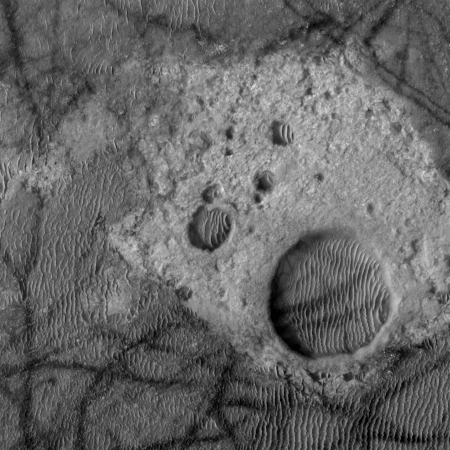
Kaiser Crater bedrock

Cool image time! This week JPL’s image site highlighted a picture taken by Mars Odyssey of the floor and dunes inside Kaiser Crater, located to the west of Helles basin in an area dubbed the Noachis Region.

To my eye, the Mars Odyssey picture was interesting, but not worth a post here on Behind the Black. However, I decided to take a look at what HiRise, the high resolution camera of Mars Reconnaissance Orbiter (MRO), had taken of the same area, just out of curiosity. A search at the master HiRise image site at the same latitude and longitude (-45 latitude, 180 longitude) showed that HiRise had imaged a part of the same area, but at much higher resolution.

When I zoomed in on this hi resolution image I came across some interesting and weird geology, cropped to show here on the right. Now this, I thought, is worth posting. Notice how the dark tracks, caused by dust devils, leave no tracks as they cut across the brighter areas. Obviously, these bright areas have no dust or sand, and are likely solid bedrock of some kind. The depressions might be craters, but they also might not. The raised area around the depressions might have been caused by the impact, or it might have been caused by some internal geological process that caused the depression while also raising the surrounding bulge. Since then the wind has been steadily depositing sand in the depressions, causing it to get trapped there.

NASA’ safety panel illustrates the impossibility of exploration by NASA

Last week NASA’s Aerospace Safety Advisory Panel (ASAP) issued its 2017 report [pdf], detailing the areas it has concerns for human safety in all of NASA’s programs. Not surprisingly, the report raised big issues about SpaceX, suggesting its manned launch schedule was questionable and that there were great risks using the Falcon 9 rocket as presently designed.

ASAP was especially concerned with the issues with the Falcon 9 COPV helium tanks and how they were connected with the September 2016 launchpad explosion, as well as SpaceX’s approach to fueling the rocket. Below is a screen capture of the report’s pertinent section on this.

ASAP SpaceX concerns

The report complements NASA and SpaceX for looking at a new design for the COPV helium tanks, but also appears quite willing to force endless delays in order to make sure the issue here is completely understood, even though this is likely impossible for years more.

ASAP also raises once again its reservations about SpaceX’s method of fueling the Falcon 9, which would have them fill the tanks after the astronauts are on board so that the fuel can be kept cold and dense to maximize performance. This issue I find very silly. The present accepted approach is to fill the tanks, then board the astronauts. SpaceX wants to board the astronauts, then fill the tanks. Either way, the astronauts will be in a rocket with tons of volatile fuel and oxidizer. I really do not see why it makes that much of a difference, especially with SpaceX building a successful track record using its approach with each successful commercial launch. They did 18 last year alone.

Below the fold is a screen capture of the report’s entire summary, with some sections highlighted by me.
» Read more

Mars rover update: January 16, 2018

Summary: Both rovers have moved little in the past month, Opportunity because it is in a good science location and because it must save energy during the winter and Curiosity because it is in a geological location so good the scientists appear to almost be going ga-ga over it.

Curiosity

null

For the overall context of Curiosity’s travels, see Pinpointing Curiosity’s location in Gale Crater.

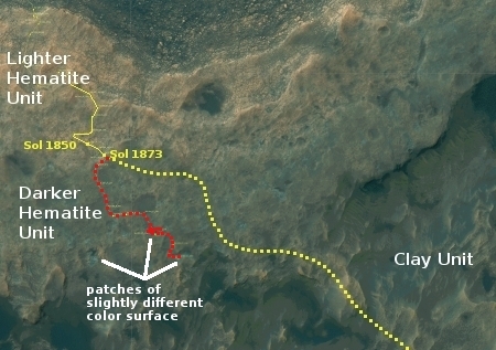
In the month since my December 18 update, Curiosity has continued to head south rather than east as originally planned (as indicated by the dotted yellow line in the traverse map to the right). Moreover, the rover has not moved very much, because the science team has decided that there is just too much significant geology in this area on Vera Rubin Ridge, also part of a geological unit they have dubbed the Hematite Unit.

Right now the rover is located at an area they call “Region e,” one of the three patches I have also indicated on the image to the right. From the second update below:

This location is a slight depression with exposed fractured bedrock that appears more “blue” from orbit than the surrounding region. In addition, the orbital evidence and observations from the ground suggest that this location is similar to “Region 10” that we visited just last week, which was shown to have some pretty spectacular small-scale features that were of particular interest to many on the science team. As a result, the team was very excited to reach “Region e” and begin our scientific investigation!

The last few updates on the Curiosity mission update page indicate the excitement the geologists have for this site:
» Read more

The known ice cliffs on Mars

Last week there was a big NASA story about the discovery of eight locations on Mars where the evidence strongly suggests that these spots have cliff faces with exposed layers of water ice.

The press release however did not provide an overview about where those eight locations were. Only two locations were given, one for a scarp in Milankovič Crater in the northern hemisphere, and one in an area called Promethei Terra, located in the remote cratered highlands in the southern high-mid-latitudes.

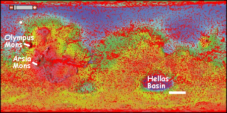
The location of known ice scarps on Mars

After much digging (and some assistance from John Batchelor) I was finally able to obtain the latitudes and longitudes of all 8 locations. All but the scarp in Milankovič Crater crater (shown by the white dot north of Olympus Mons) are located in the white rectangular box shown to the south and east of Hellas Basin, the area with Mars’ lowest elevation. This part of Mars is not well imaged with the high resolution camera on Mars Reconnaissance Orbiter (indicated by the fewer number of red squares in the image), mostly because it appears relatively boring from a distance. Nothing appears to be there for hundreds and hundreds of miles except craters, sand, and sand dunes..

The discovery of these scarps in this area however changes the picture. It suggests that cratered highlands that surround Hellas Basin, including those close to the planet’s equator, could contain similar buried layers of ice. More research is necessary to pin down more locations, especially those closer to the equator where conditions might be more hospitable for a colony.

Moreover, educated readers of Behind the Black have previously noted that because of Hellas Basin’s low elevation the air pressure there is thicker, and therefore the location has some advantages as a potential colony location. These ice scarps raise the value of Hellas Basin considerably, as they suggest that such layers could easily be exposed as you descend into Hellas Basin. If such layers are exposed on the northern flanks of the basin, they would be at latitudes of around 25 to 30 degrees south, a much more friendly latitude for settlement.

A spectacular collapse feature at Arsia Mons

Collapse at Arsia Mons

Cool image time! This post could be called an update to my January 8th post, Exploring Arsia Mons. In that post I had compiled together the ten images of Arsia Mons, the southernmost volcano in the line of three giant volcanoes on Mars, that JPL had highlighted over several weeks in early January.

Today, I decided to do some of my own exploration of some of the many images taken of Arsia Mons by all of the Martian orbiters. My goal had been to explore the volcano’s western slopes (an area that had not been featured in the JPL releases) because that is the area where research has found evidence of past glacial activity as well as seasonal water clouds. I haven’t finished that survey, but in the process I came across a spectacular image of a collapse that had been visible in image nine of the January 8th post, but did not stand out there because of the lighting. The image on the right is that better image, cropped to focus in on the collapse itself.

The material at the base of the wall resembles piled up mud, which suggests this collapse is a Martian version of a mud slide. If so, it also suggests the presence of liquid. At the same time, the muddy look might not be from liquid but because of the lighter Martian gravity causing avalanches to be appear different there. The light gravity means material is not as dense, so when it collapses it might break apart more easily into a sandy type flow.

I am only an amateur geologist, so my theories here should not be taken very seriously. Nonetheless, I am sure there are planetary geologists who have looked at this closely because of the information about Martian geology that they can glean from it. I’d be curious to hear their thoughts.

Meanwhile, my exploration of the western slopes of Arsia Mons will continue. In Pioneer the science fiction book I wrote in the early 1980s (now available), I placed my Martian colony in Mangala Valles, a meandering canyon to the west of Olympus Mons that feeds out from the higher southern regions into the lower northern flat plains where even then some scientists thought an ocean might have once existed. My thinking then was that this might be a good location to find underground water. It now appears, with our greater knowledge, that the slopes of the volcanoes themselves might be more promising, and I am curious to find the most likely places in this region where a future colony might end up.

Exploring Arsia Mons

Master index

In November over a period of two weeks the Mars Odyssey team posted ten images of Pavonis Mons, the smallest of the aligned three giant volcanoes just to the east of Olympus Mons, the largest known volcano in the solar system. I then made all of those images available in a single link, with some analysis.

They have now done the same thing for the southernmost (and possibly the most interesting) of those three aligned volcanoes, Arsia Mons. From the first image below:

Arsia Mons is the southernmost of the Tharsis volcanoes. It is 270 miles (450km) in diameter, almost 12 miles (20km) high, and the summit caldera is 72 miles (120km) wide. For comparison, the largest volcano on Earth is Mauna Loa. From its base on the sea floor, Mauna Loa measures only 6.3 miles high and 75 miles in diameter. A large volcanic crater known as a caldera is located at the summit of all of the Tharsis volcanoes. These calderas are produced by massive volcanic explosions and collapse. The Arsia Mons summit caldera is larger than many volcanoes on Earth.

In other words, you could fit almost all of Mauna Loa entirely within the caldera of Arsia Mons.

The image on the right above is the master index, annotated by me to show the area covered by each image. The images can accessed individually below.
» Read more

1 20 21 22 23 24 48