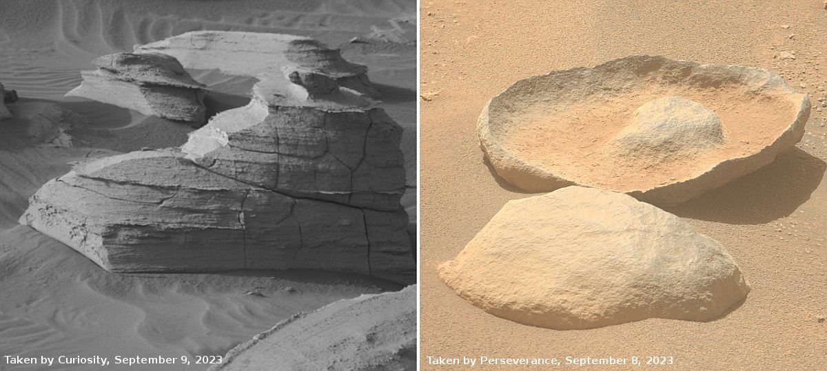
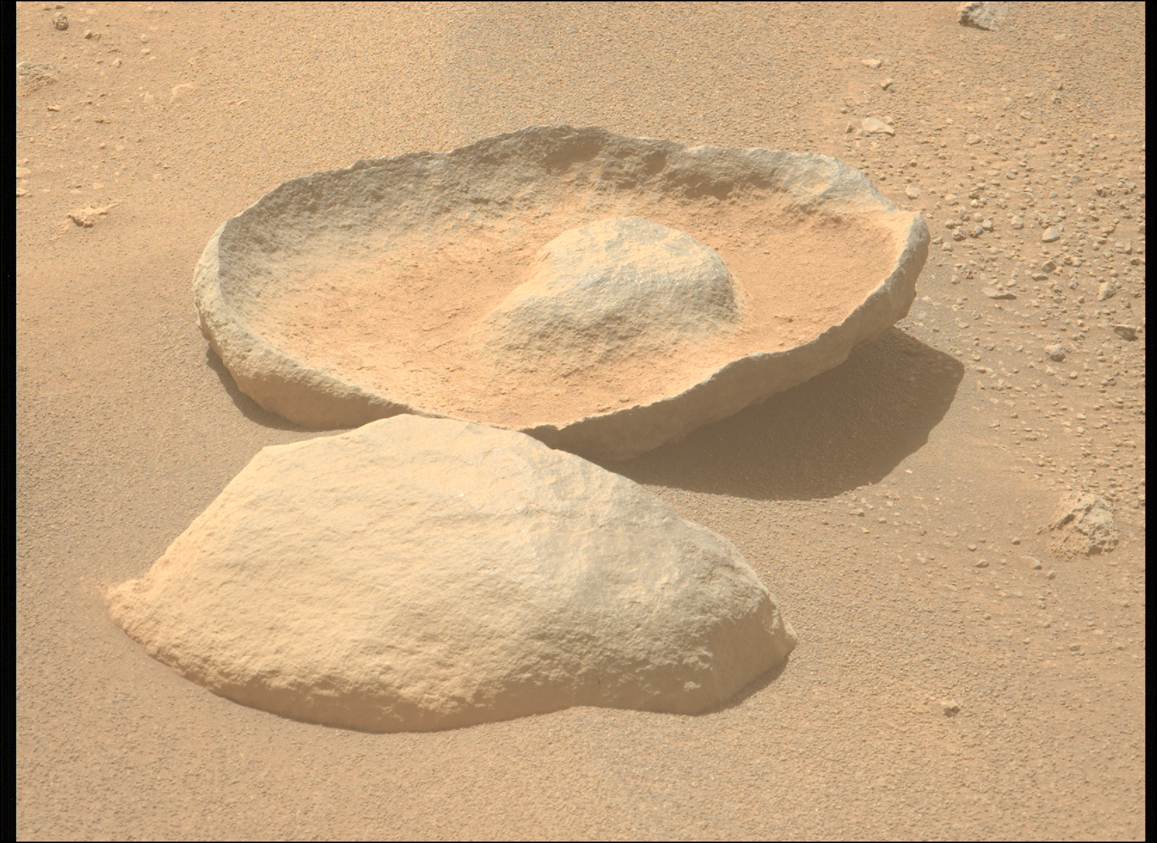
Data from Perseverance confirms Jezero Crater once held a lake

figure 5 from paper showing ancient lake in Jezero Crater

According to a newly published paper, the data obtained by the rover Perseverance has confirmed and refined what orbital data has suggested, that Jezero Crater once held a lake. From the abstract:

We analyze images taken by the rover in the three months after landing. The fan has outcrop faces that were invisible from orbit, which record the hydrological evolution of Jezero crater. We interpret the presence of inclined strata in these outcrops as evidence of deltas that advanced into a lake. In contrast, the uppermost fan strata are composed of boulder conglomerates, which imply deposition by episodic high-energy floods. This sedimentary succession indicates a transition, from a sustained hydrologic activity in a persistent lake environment, to highly energetic short-duration fluvial flows.

In other words, the crater first held a lake, which as it slowly dried out was periodically renewed by flash floods. The distinct delta of material that made Jezero Crater the prime landing site was apparently formed during the period when the lake existed. The conditions that caused the subsequent flash floods is as yet not been determined, though it likely is related to the red planet’s long term evolution.

The image above, figure 5 from the paper, shows the inferred lake in that early history. The red cross marks Perseverance’s landing site.

This data reinforces the fundamental scientific mystery of Mars. It shows evidence that liquid water once flowed on the surface of Mars, even though other long term data of the planet’s history says the Martian atmosphere has been too thin and too cold to allow that to happen. There is evidence that the atmosphere might have once been thicker, but no computer model or theory has been able to produce a time when it was warm enough.

Report: Reduce contamination restrictions for some future Mars missions

A new policy paper from the National Academies has proposed reducing the planetary protection rules for some future Mars missions, concluding that Earth life cannot survive on Mars for long, and as long as a lander or rover does not land close to cave entrances or on extensive ice, the need to decontaminate is significantly reduced. From the press release:

In this report, the Committee focused on regions on Mars that might not be negatively impacted if visited by spacecraft that are not stringently sterilized. For missions that do not access the subsurface, such regions could include a significant portion of the surface of Mars, because the UV environment is so biocidal that terrestrial organisms are, in most cases, not likely to survive more than one to two sols, or Martian days. For missions that access the subsurface (down to 1 meter), regions on Mars expected to have patchy or no water ice below the surface might also be visited by spacecraft more relaxed bioburden requirements, because such patchy ice is likely not conducive to the proliferation of terrestrial microorganisms.

The report finds that it is imperative that any mission sent to Mars with reduced bioburden requirements remain some conservative distance from any subsurface access points, such as cave openings. Furthermore, though less stringent than current requirements, these missions with relaxed bioburden requirements would still need some level of cleanliness, which could be achieved for instance using standard aerospace cleanliness practices.

The report essentially concluded that missions to Mars’ dry equatorial regions as well as its glacial mid-latitudes pose no risk to contaminating the red planet with Earth life.

While the press release pushes the idea that this is a reduction in the planetary protection rules, it could be seen in a much worse light. Based on the proposed rules, missions to the Martian poles or higher latitudes, where ice is extensive and not “patchy,” might be entirely forbidden. This will significantly limit Martian exploration by the United States. Meanwhile, China and Russia and others will be faced with no such restrictions.

Note too that this report likely forbids SpaceX from landing its Starship in the company’s candidate landing sites, all of which are in the northern lowland plains ranging from 35 to 40 degrees north latitude. This region is thought to have extensive ice sheets very close to the surface. To land there, the rules proposed will either require extremely strict and very costly decontamination procedures, many of which do not even exist as yet, or will forbid landing there at all.

The wavy and beautiful edge of the northern ice cap of Mars

The scarp of the north pole icecap on Mars
Click for full image.

Cool image time! The photo to the right, cropped and reduced to post here, was taken on August 7, 2021 by the high resolution camera on Mars Reconnaissance Orbiter (MRO). It shows the many layered scarp that forms the edge of the northern polar ice cap on Mars, probably more than 2,000 feet high.

Those layers are significant, as they indicate the many climate cycles that scientists think Mars has undergone over the eons as the red planet’s rotational tilt, or obliquity, rocked back and forth from 11 degrees inclination to as much as 60 degrees. At the extremes, the ice cap was either growing or shrinking, while today (at 25 degrees inclination) it appears to be in a steady state.

Why the layers alternate light and dark is not known. The shift from lighter colors at the top half and the dark bottom half marks the separation between the top water ice cap and what scientists label the basal unit. It also marks some major change in Mars’ climate and geology that occurred about 4.5 million years ago.
» Read more

Land of Martian slope streaks

Land of Martian slope streaks
Click for full image.

Cool image time! The photo to the right, cropped and reduced to post here, was taken on May 21, 2021 by the high resolution camera on Mars Reconnaissance Orbiter (MRO). It shows a typical example of the many slope streaks found in the rough and very broken region north of the Martian volcano Olympus Mons, the largest in the solar system.

See this May 2019 post for a detailed explanation of slope streaks. While they appear to be avalanches, they do not change the topography of the ground, sometimes flow over rises, and appear to be a phenomenon entirely unique to Mars. While no theory as yet explains them fully, the two most favored postulate that they are either dust avalanches or the percolation of a brine of chloride and/or perchlorate in a thin layer several inches thick close to the surface. In both cases the streak is mostly only a stain on the surface that fades with time.

The location of this cool image however tells us something more about them.
» Read more

Inactive volcano vent on Mars

Inactive volcanic vent on Mars
Click for full image.

Overview map

Cool image time! The photo to the right, cropped, reduced and annotated to post here, was taken on July 30, 2021 by the high resolution camera on Mars Reconnaissance Orbiter (MRO). The left image shows a pit that the scientists label a “vent” near the giant volcano Pavonis Mons. The right image is identical, except that I have brightened it considerably to bring out the details in the shadowed area.

As you can see, this pit is filled, and does not appear to have any existing openings into more extensive underground passages.

The white dot on the overview map on the right shows this vent’s location, to the south of Pavonis Mons, and in line with the giant crack that splits three of Mars’ four largest volcanoes. The vent is even aligned the same as that crack, from the northeast to the southwest. The black dots mark the locations of the many cave pits found in this region.

Was this a volcanic vent? If you look at the full image you will see that this pit aligns with a shallower pit to the southwest, with a depression linking the two. Visually this suggests this is a faultline which in turn makes for a good outlet point for lava flow.

Though the data suggests this is a volcanic vent, that supposition is as yet unproven. The full image does not show much evidence of a flow from the pit, which suggests instead that we are merely looking at a spot where the ground cracked along fault lines.

Ingenuity’s 14th flight scrubbed by helicopter

Though Ingenuity successfully completed a preflight high speed test of its rotors on September 15th, when it came time to do its fourteenth flight two days later, intended as a short airborne test of that high speed, the helicopter’s computer sensed an issue prior to take-off and scrubbed the flight.

The goal of the high speed test and short flight were to see if Ingenuity could fly during the winter months when the atmosphere of Mars is thinner, thus requiring a higher rotor speed. Initially it was not expected the helicopter would still be operational at this point, so this is another example of it pushing its expected capabilities. The scrub however might be signalling the end date for Ingenuity, related to servo motors that help control the helicpoter:

Ingenuity performs an automated check on the servos before every flight. This self-test drives the six servos through a sequence of steps over their range of motion and verifies that they reach their commanded positions after each step. We affectionately refer to the Ingenuity servo self-test as the “servo wiggle.”

The data from the anomalous pre-flight servo wiggle shows that two of the upper rotor swashplate servos – servos 1 and 2 – began to oscillate with an amplitude of approximately 1 degree about their commanded positions just after the second step of the sequence. Ingenuity’s software detected this oscillation and promptly canceled the self-test and flight.

Our team is still looking into the anomaly. To gather more data, we had Ingenuity execute additional servo wiggle tests during the past week, with one wiggle test on Sept. 21, 2021 (Sol 209) and one on Sept. 23, 2021 (Sol 211). Both of the wiggle tests ran successfully, so the issue isn’t entirely repeatable.

One theory for what’s happening is that moving parts in the servo gearboxes and swashplate linkages are beginning to show some wear now that Ingenuity has flown well over twice as many flights as originally planned (13 completed versus five planned). Wear in these moving parts would cause increased clearances and increased looseness, and could explain servo oscillation. Another theory is that the high-speed spin test left the upper rotor at a position that loads servos 1 and 2 in a unique, oscillation-inducing way that we haven’t encountered before.

Because communications with Mars are now paused for two weeks because the Sun is in the way, the engineering team is holding off further tests until communications resume.

A Mars mesa carved by floods and lava?

Overview map of Kasei Valles

With today’s cool image we once again start our journey from afar, and zoom in. The overview map to the right focuses in on the thousand-mile-long Kasei Valley on Mars.

The blue area is where scientists postulate a lake once existed, held there by an ice dam (indicated by the white line). At some point that ice dam burst, releasing the water in a catastrophic flood that created the braided flow features that continue down Kasei Valles to the northern lowland plain of Chryse Planitia.

The black area marks a giant lava flow that scientists believe came later, following the already carved stream channels for a distance of 1,000 miles, traveling at speeds of 10 to 45 miles per hour.

The red dot near the Kasei Valles resurgence is today’s cool image.
» Read more

Flooding from crater lakes on Mars

Loire Valley on Mars

According to a new paper published today, scientists estimate that flooding from crater lakes on Mars — caused by sudden breaches in the crater rims — could have created as much as 25% of the volume of the valley networks that have been identified there.

Mars’ surface hosted large lakes about 3.5 billion years ago. Some of these lakes overtopped their rims, resulting in massive floods that rapidly formed deep canyons. Similar lake breach floods occurred in the northwest United States and central Asia at the end of the last glacial period over 15,000 years ago.

“We found that at least a quarter of the total eroded volume of Martian valley networks were carved by lake breach floods. This high number is particularly striking considering that valleys formed by lake breach floods make up just 3% of Mars’ total valley length,” Morgan said. “This discrepancy is accounted for by the fact that outlet canyons are significantly deeper than other valleys. These floods would have shaped the overall Martian topography, affecting the flow paths of other valleys. Our results don’t negate the importance of precipitation-fed runoff on early Mars. On the contrary, liquid water had to be stable for long enough for lakes to fill from inlet rivers.” [emphasis mine]

The map above shows in white the Loire Valles on Mars, located at about 20 degrees south latitude in transition zone between the northern lowland plains and southern cratered highlands. The paper cites this valley as a typical example of a flood valley caused by a crater rim breach.

This research only makes the geological and climate history of Mars more puzzling. Though the geological evidence strongly suggests lakes and liquid water once existed on Mars, and this research strengthens that conclusion (as indicated by the highlighted sentence above), no model of the planet’s climate has ever satisfactorily created a situation where that was possible. Either there are factors about Mars’ ancient history we have not yet identified (likely) and don’t yet understand (very likely), or the planet’s geology was formed by processes alien to Earth and thus not yet recognized by us.

Perseverance as seen from orbit

Perseverance as seen from orbit
Click for full image.

Overview map
Click for interactive map.

The science team for the high resolution camera on Mars Reconnaissance Orbiter (MRO) have snapped a picture of Perseverance at its present location in Jezero Crater.

The first image to the right, cropped to post here, shows the rover as a white dot to the right of the two long sand dunes. If you look close image, you can see the rover’s tracks near the bottom of the image.

Ingenuity is likely also in the full image, but is likely too small for MRO’s high resolution camera to pick out.

The second image is a overview map. The green dot marks the rover’s position, with the red dot Ingenuity’s present position. The dotted white line shows the route the rover has taken so far. The light brown line indicates the flight paths for all of Ingenuity’s flights. The yellow dotted line indicates the future planned route of Perseverance.

With Mars about to slip behind the Sun, communications with both rovers, Perseverance and Curiosity, as well as all the orbiters, will shortly go silent for about two weeks.

When that pause ends, the question will be where Perseverance goes next. The original plan was to retreat back along its previous path, going to the southeast before heading north past the landing site. I strongly suspect that they will instead head directly to the landing site, going to the northeast across the rough terrain, both to see something new as well as further test the rover’s ability to travel tougher ground.

They avoided that area initially because they were still in the rover’s check out period. Now that they know it works, there is no reason to avoid that ground, especially because it will be ground they have not viewed before. They could even use Ingenuity to scout it out more thoroughly.

Rivulets in Martian lava

Overview map

Today’s cool image is another example of scientists finding cool things hidden within distant pictures. The small white rectangle on the overview map to the right shows us where we are heading, to the severely eroded lava plains to the southwest of Mars’ largest volcano, Olympus Mons.

The white spot is about 500 miles from the caldera of Olympus Mons. In elevation it sits about 58,000 feet below that caldera, more than twice the height of Mt. Everest. Yet, despite these great distances, the material at that white rectangle was almost certainly laid down during an eruption from Olympus Mons, thus illustrating the gigantic scale of volcanic events on Mars. Because of the red planet’s light gravity, about 38% of Earth’s, not only can lava flow farther, it does so much faster.

The second image below is a wide angle photo taken by the context camera on Mars Reconnaissance Orbiter (MRO) in January, 2012, rotated, cropped, expanded, and enhanced to post here.
» Read more

Glaciers in the Martian south latitudes

Glaciers in Mars' southern hemisphere
Click for full image.

Most of the glacier cool images I have posted in the past few years from the high resolution camera on Mars Reconnaissance Orbiter (MRO) have shown the obvious glacial features found in the northern hemisphere in that 2,000 mile long strip of chaos terrain at about 40 degrees latitude I dub “Glacier Country.”

Today’s glacier image to the right, cropped and reduced to post here, takes us instead to the southern hemisphere, into Hellas Basin, the death valley of Mars. The picture was taken on April 8, 2021, and in the full picture gives us a myriad of examples of glacial features. The section featured to the right focuses in on what appears to be an ice covered south facing slope, which in the southern hemisphere will get the least sunlight.

Think of the last bits of snow that refuse to melt after a big blizzard. They are always found in shadowed areas, which in the southern hemisphere would be this south-facing slope.

The overview map below shows how this location, marked by the small white rectangle, is inside Hellas Basin, at a low altitude comparable to the northern lowland plains. The feature is also a comparable latitude, 43 degrees south, to the glacier country of the north.
» Read more

InSight detects the three more large quakes on Mars, the most powerful measured so far

In the past month InSight’s seismometer has detected the three most powerful earthquakes so far measured on Mars, with one located in a region where no quakes had as yet been seen.

InSight spotted 4.2- and 4.1-magnitude temblors on Aug. 25, then picked up another roughly 4.2-magnitude quake on Sept. 18 that lasted for nearly 90 minutes, NASA officials announced on Wednesday (Sept. 22).

The previous record holder, which InSight measured in 2019, clocked in at magnitude 3.7 — about five times less powerful than a 4.2-magnitude quake.

At this time scientists have only been able to roughly pinpoint the location of the two August quakes, with the 4.1 quake occurring about 575 miles away, putting it in the volcanic plains where InSight sits and closer than the location of most of the previous large quakes near the long surface fissures dubbed Cerberus Fossae 1,000 miles away.

The August 4.2 quake’s is even more interesting, as its location is the farthest away of any so far detected, at an estimated distance of 5,280 miles away. The scientists presently suspect but have not yet confirmed that it may be located in the western end of Valles Marineris, Mars’ largest canyon.

The lander itself continues to fight a loss of power due to the amount of dust on its solar panels, forcing the science team to shut down practically all its other instruments so that the seismometer could continue operating.

A clue to the Martian history of volcanic eruptions

Dark layers in Medusae Fossae Formation
Click for full image.

Anyone who has taken even a single glance at a map of Mars cannot help but recognize that the red planet was once engulfed with repeated gigantic volcanic eruptions able to build numerous volcanoes larger than anything seen anywhere else in the solar system.

The cool image to the right, rotated, cropped, and enlarged to post here, provides a clue into those past eruptions, now thought to have been active for more than several billion years, with the most recent large activity ending several tens of millions of years ago. The photo was taken on May 7, 2021 by the high resolution camera on Mars Reconnaissance Orbiter (MRO), and shows just one tiny portion of the vast Medusae Fossae Formation, the largest thick volcanic ash deposit on Mars, about the size of India and what scientists think is the source of most of the planet’s dust.

What makes this picture interesting are the dark layers in the lower hollows. They indicate that this deposit was placed down in multiple eruptions, some of which produced material that appears dark blue in MRO images, and suggest that eruption was different than previous and subsequent eruptions.

The white cross on the overview map below notes the location of this picture in the Medusae Fossae Formation.
» Read more

Martian mountaintop

Mountains on Mars
Click for full image.

The outcrop top
Click for full image.

Cool image time! The photo to the right, cropped, reduced, and enhanced to post here, was taken on September 21, 2021 by Curiosity’s high resolution mast camera, and shows the top of that spectacular rock outcrop about 200 feet to the west of where the rover presently sits. The top image, from my September 16, 2021 post, “Curiosity: Into the Mountains!”, indicates the location of the photo with the black rectangle. The red dotted line indicates the rover’s future planned route.

I estimate the whole outcrop is about 100 feet high, which means the cliff section seen in the photo to the right is probably about 30 feet high. It would make a great challenge for any number of rock climbers I know.

What makes this image especially striking are the overhanging rocks at the peak’s top. In the Martian gravity, about one third that of Earth’s, it is possible for much more delicate rock shapes to remain structurally stable, and the sharp jagged boulders hanging out at the top of this cliff demonstrate that in a quite breath-taking way. On Earth such delicate rocks would likely have quickly fallen.

The Curiosity science team is obviously most interested in the massive layers revealed by this cliff. I am also sure they are also as enthralled by the scenery as I am.

How to discover interesting things on Mars

Overview map

Today’s cool image will do something a little different. We are going to begin in orbit, and by step-by-step zooming in we will hopefully illustrate the great challenge of finding cool geological features on the surface of Mars.

The first image to the right is an overview map of the Valles Marineris region. To its east, centered at the white dot, is a vast region of chaos terrain, endless small buttes and mesas and criss-crossing canyons. Travel in this region will always be difficult, and will likely always require some form of helicopter to get from point to point.

What is hidden in that terrain? Well, to find out you need to take a global survey from orbit with a good enough resolution to reveal some details. Below is a mosaic made from two wide angle context camera pictures taken by Mars Reconnaissance Orbiter (MRO).

Context mosaic of chaos terrain
For full images go here and here.

This mosaic, rotated, cropped, and reduced to post here, only captures a small section of the long north-south strips taken by MRO. The orbiter has taken tens of thousands of these strips, in its effort to produce a global map of Mars that shows some reasonable detail.

Do you see anything in this mosaic that looks interesting? Scientists need to pore over such images, one by one, searching for geology that is both puzzling and revealing. Sometimes the features are obvious, such as a single blobby crater in the flat relatively featureless northern lowlands.

Sometimes however the search can be slow and time-consuming because the terrain is complex, as is the example to the right. The many mesas and canyons can hide many interesting features. Since MRO can’t possibly take high resolution photos of everything, scientists have to pick and choose.

The planetary scientists who use MRO did find something here worth looking at in high resolution. Can you find it? Normally I’d provide a box to indicate it, but this time I’d thought I’d challenge my readers. Before you click below to see the feature, see if you can find it yourself in this mosaic. What would you want to photograph in high resolution?
» Read more

Glacial falls on Mars

A glacial falls on Mars
Click for full image.

Cool image time! The photo to the right, cropped and reduced to post here, was taken on July 2, 2021 by the high resolution camera on Mars Reconnaissance Orbiter (MRO). It provides us just one more clear example of the many glaciers found in that 2,000-mile-long strip of chaos terrain at 30 to 47 degrees north latitude that runs between the northern lowland plains and the southern cratered highlands, a region I like to call Mars’ glacier country.

What makes this glacial feature interesting is that these ice-filled alcoves are south-facing, which in the northern hemisphere means they get the most sunlight. Yet, the ice here remains, well-protected by its layer of dust and debris. Think of the dirty ice slush that manages to survive the longest on city streets in the spring. The dirt acts as protection so that the ice takes more time to melt.

The overview map as always provides our context.
» Read more

Badlands on the floor of a Martian crater

Badlands on the floor of a Martian crater
Click for full image.

Cool image time! The photo to the right, rotated, cropped, and reduced to post here, shows one small section of a 30-mile-wide unnamed crater in the cratered equatorial regions of Mars northeast of Hellas Basin. Taken on July 21, 2021 by the high resolution camera on Mars Reconnaissance Orbiter (MRO), the science team labeled merely as “Rocky crater fill.”

Being at 17 degrees south latitude, there shouldn’t be any ice features in this crater, and the high resolution image to the right seems to confirm this. All we see is an endless plain made up of innumerable small sharp rock ridges interspersed with small low areas filled with sand dunes. This is bed rock, and if its strange stucco-like appearance was caused by a past glacial era, that era is long gone.

Below is a mosaic showing the entire crater, created from two MRO context camera images.
» Read more

Curiosity: Into the mountains!

Curiosity's path into the mountains
Click for full image.

Overview map
Click for interactive map.

Time for another cool image from Curiosity. The photo above was taken by one of the rover’s navigation cameras today, and looks south in the direction of Curiosity’s future travels. The red dotted line shows that planned route, along the cliff face to then turn west into what the science team has dubbed Maria Gordon Notch, in honor of a Scottish scientist from the early 20th century.

The map to the right gives the context as seen from above, as well as the planned travels beyond the notch. The white dotted route marks Curiosity’s actual travel route. The red dotted line marks the planned route. The yellow lines the area seen in the above picture.

At present Curiosity is paused as it performs a new drilling campaign about 200 feet from the base of that cliff face, drilling the rover’s 33rd hole on Mars.

The outcrop resembling a ship’s prow on the image’s right, which I still consider the most spectacular rock outcrop seen yet on any planetary mission anywhere, is about 100 feet high.

Lozenge-shaped hole in Martian crater

Hole in crater floor
Click for full image.

Cool image time! The photo to the right, rotated, cropped, reduced, and enhanced to post here, was taken on June 7, 2021 by the high resolution camera on Mars Reconnaissance Orbiter (MRO).

The left image shows what the scientists have dubbed a “lozenge-shaped depression” in the middle of an unnamed 60-mile-wide crater in the southern cratered highlands of Mars. The right image shows the same exact depression, but I have brightened the photo in order to see the details in the shadowed depression.

Though the image is inconclusive, the bottom of the darkest spot in that depression cannot be seen, suggesting it could be an entrance into a larger void below.

Even if there is no voids below, why is this depression here? What caused it? The wider view of MRO’s context camera below might give us a hint.
» Read more

The layered history of Mars as revealed in Valles Marineris

Layered cliff in Valles Marineris
Click for full image.

Cool image time! The photo to the right, rotated, cropped, and reduced, shows just one tiny cliff face in the gigantic canyon on Mars dubbed Valles Marineris. The photo was taken on June 13, 2021 by the high resolution camera on Mars Reconnaissance Orbiter (MRO).

Like many other similar cliff faces that MRO has photographed and that I have previously highlighted, there are many many layers visible here. In fact, it appears that almost every cliff in this part of Valles Marineris is many layered, suggesting that like the Grand Canyon on Earth, the canyon as it was carved exposed in great detail the long geological history of Mars.

In this part of Mars, each layer probably represents the placementof a new layer of volcanic material, pouring out from the giant volcanoes in the Tharsis Bulge to the west. In addition, overlain on this volcanic record are probably deposits lain down by the atmosphere as Mars underwent its many climate cycles due to the regular shifts in its orbit and rotational tilt.
» Read more

Make concrete on Mars using human blood?

What could possibly go wrong? Scientists at the University of Manchester in the United Kingdom have developed a new formulation that can use material known to exist on Mars, combined with the addition of astronaut blood, to produce useful concrete.

Working with simulated lunar and Martian soils, the team experimented with using human blood and waste products as binding material, and turned up some interesting results.

The work showed that a common protein in the blood called serum albumin could be used as a binder to produce a concrete-like material with compressive strength comparable to ordinary concrete. In investigating the mechanisms at play, the team found the blood proteins “curdle” to form “beta sheets” that extend outward to hold the material together.

Even more interestingly, the team found that urea, a waste product found in urine, sweat and tears, could be incorporated to increase this compressive strength by more than 300 percent. That is to say, the key to cosmic concrete stronger than what we have here on Earth might be found in our blood, sweat and tears (and urine).

This work was inspired by ancient building techniques, which often used pig blood in concrete for similar reasons.

Though a lot of this makes sense, especially the utilization of waste products like urine, the idea that future colonies will tap the blood of their citizens for construction purposes raises so many moral questions I can’t list them all here.

For example, let me throw out one possibility should no one think about this too much on Mars. Why not use this need for blood as a method of criminal punishment? Do something the ruling powers think is wrong and we will suck your blood from you to build the colony!

The moral consequences of our actions require long careful thought. Unfortunately, long careful thought simply no longer exists among today’s intellectual and political classes. Instead, they make almost all their decisions off the cuff, based on what “feels” right to them. You merely have to watch the many interviews of Dr. Anthony Fauci in the past year to see what I mean. Nothing he says about masks or mandates is really based on new research or data. He merely throws out an opinion that feels right, at the moment. Thus, he contradicts himself repeatedly, and most of his advice has been worse than useless, resulting in so many unexpected negative consequences they almost cannot be counted.

Try to imagine the horrors that could take place in a colony on Mars, where resources are in short supply, should construction require the use of human blood and the leadership there approaches its problems with the same cavalier attitude toward moral consequences? I can, and it chills my own blood to the core (no pun intended).

An example why scientists think there were catastrophic floods on Mars

Broken mesas on Mars
Click for full image.

Today’s cool image provides a nice illustration why scientists have long assumed that in the distance past there had been catastrophic floods of liquid water on Mars. The photo to the right, rotated, cropped, and reduced to post here, was taken on July 6, 2021 by the high resolution camera on Mars Reconnaissance Orbiter (MRO). It shows an east-west gully cutting between mesas to the north and south.

Because the highest mesas seem to be aligned, this suggests they were once part of the same formation, and something came along to carve that gap and gully between them.

What made the break? The overview map below as usual provides some context, which also provides a possible explanation.
» Read more

Data from Opportunity suggests surface dew periodically appears even in the dry equatorial regions

Using data from the rover Opportunity, scientists now think that the renewal of Martian salt crusts on rock surfaces on the rim of Endeavour Crater could possibly by caused by the appearance of rare thin wetting events, and that such events could have even occurred very recently and be on-going..

The scientists looked at the rate of erosion and renewal of the salt crusts, and found them to be in a steady state. The erosion is slow, taking from 200,000 to 2,000,000 years to remove 1 to 2 millimeters. However, periodically a thin film of water or wetting occurs, not unlike dew on Earth, which quickly acts to renew the crust. As David Mittlefehldt of the Astromaterials Research Office at the Johnson Space Center and the lead author of the paper explained to me,

Taken together, the data leaves open the possibility the salt mobilization has occurred within the last few thousand years. It could be ongoing in the sense that over a period of thousands? or hundreds? of years it might happen again.

In other words, the evidence suggests that every few hundred or thousand years the surface of these rocks gets wet, which results in the placement of a new thin layer of salt crusts.

Mittlefehldt also emphasized to me that these wetting events are rare, and “there is also the case that such an event may never come again because of changing conditions.”

The situation is essentially like on Earth, where in some places hydrologists measure the size of floods by how rare they are. A 1,000 year flood is big, but it happens very rarely. At Endeavour Crater these wetting events are comparably rare, but they do not involve big floods, but a mere moistening of the ground.

The location of Endeavour Crater is about 2 degrees south latitude, so it sits in the dry equatorial regions where no surface or near surface ice has so far been found. However, the cyclic nature of Mars’ orbit and obliquity could have changed this in the past, and could change this again in the future. At this time we simply don’t have enough information to know.

On the edge of Mars’ glacier country

Color dry mesas on Mars
Click for full image.

Today’s cool image sits right on the southern edge of Mars’ northern glacier country, at 29 degrees north latitude. The picture to the right, cropped and reduced to post here, was taken of this location on June 4, 2021 by the high resolution camera on Mars Reconnaissance Orbiter (MRO). It shows what appears to be the exposed and scraped bedrock and mesas on the floor of an unnamed 60-mile-wide crater.

That scraped bedrock is quite beautiful, reminiscent of the bare carved mesas and bedrock one sees throughout the southwest of the United States. To hike from that central valley to the top of the bright mesa would be a fine experience, especially because of the suggested change in colors in the color strip.

The overview map below gives more context.
» Read more

Glaciers and mesas on Mars

Overview map

Cool image time! Today we return to glacier country on Mars, that band of mensae mesas and glaciers that stretches more than 2,000 miles in the northern mid-latitudes, as shown on the overview map above.

No rovers or landers have yet visited this region, nor are any planned. To the west just beyond the map’s left edge is the planned landing site of Europe’s Franklin rover. To the east and south and just beyond the map’s right edge is where America’s Perseverance rover presently travels in Jezero Crater.

Our journey today begins from afar, and will steadily zoom into the area of the red cross and a most intriguing feature seen in a recent picture taken by the high resolution camera on Mars Reconnaissance Orbiter (MRO).

Before we look at that high resolution image, it is better to view the area using MRO’s context camera, as what it shows helps make sense of the features in the close-up.
» Read more

Ingenuity completes 13th flight

Ingenuity landing on September 5, 2021
Click for full image.

Though the full slate of images taken has not yet been released, it appears from the five images available that the thirteenth flight of Ingenuity on September 5, 2021 ended successfully. The photo to the right is the last available, and shows the helicopter’s shadow on the ground mere seconds before touch down. The landing legs’ shadows suggest it is oriented properly for that landing.

No word yet on how successful the flight itself was. The goal had been to fly back over the South Seitah area from a different angle and lower altitude, getting different perspectives of the ridges there to help plan Perseverance’s coming travels across that terrain.

The second picture below, cropped, reduced, and enhanced to post here, was taken about forty minutes before take-off by Perseverance and captures Ingenuity in the lower left, as indicated by the arrow.
» Read more

Perseverance’s 2nd drill attempt to get sample appears successful

It appears that Perseverance’s second drill attempt on Mars has successfully obtained sample material in its core.

Data received late Sept. 1 from NASA’s Perseverance rover indicate the team has achieved its goal of successfully coring a Mars rock. The initial images downlinked after the historic event show an intact sample present in the tube after coring. However, additional images taken after the arm completed sample acquisition were inconclusive due to poor sunlight conditions. Another round of images with better lighting will be taken before the sample processing continues.

Once they know for sure if they have a sample, they will store it and then move on, heading to the area that Ingenuity scouted for them in mid-August.

Posted halfway to Las Vegas.

A peanut-shaped crater in the northern plains of Mars

Context camera image of peanut-shaped crater
Click for full image.

Cool image time! The photo to the right, rotated, cropped and reduced to post here, was taken in May 2008 by the wide angle context camera on Mars Reconnaissance Orbiter (MRO). It shows what the scientists have since labeled a “peanut-shaped crater.”

What caused this unusual shape? The obvious and most likely explanation is that this was a double impact that occurred simultaneously. Imagine the ground being hit either by an asteroid with two lobes or by two similar-sized asteroids falling side-by-side.

Fast forward thirteen years to 2021. In the fifteen years since 2006 when MRO begin science operations in orbit around Mars no high resolution images were taken of this crater. Finally, on July 30, 2021, scientists finally decided to take a high resolution image of this crater’s western half. You can see that image below, rotated, cropped, and reduced to post here.
» Read more

China building Ingenuity copycat

Ingenuity vs China

China’s space program revealed yesterday that it is designing its own Mars helicopter for future missions to the Red Planet.

The picture to the right shows this Chinese helicopter prototype on the bottom, with Ingenuity on Mars on top.

Notice the similarity? In fact, one could almost say that the Chinese helicopter is an outright steal of the JPL design.

But then, why not? According to an 2019 inspector general report [pdf], China hacked into JPL’s computers twice from 2009 to 2017 and stole 500MB of data. That data almost certainly included the design plans for Ingenuity, under development at the time.

Copying the work of others is expected, especially when that design is found to work. In this case however it almost certainly isn’t copying, but outright theft.

Of course, that has been par for the course for China’s space program. They don’t appear to be capable of innovating on their own. They first must steal someone else’s design, and then revise and upgrade from that. Their final products might be of high quality, but in the end their long term ability to build something new is going to be severely limited, if they cannot start inventing things on their own.

A Martian sunset in Jezero Crater

Sunset on Mars
Click for full image.

Cool image time! The photo to the right, reduced slightly to post here, was taken by the left navigation camera on the Mars rover Perseverance. Looking west to the rim of Jezero Crater, it catches the Sun as it sets behind that rim.

The image was taken on July 20, 2021, the 52nd anniversary of the Apollo 11 landing on the Moon. Seems somehow fitting to catch a sunset on Mars on this date, to illustrate how far we have come in that half century.

To my mind, not enough. Our ability to send robots to other worlds has certainly improved, but in 1969 we were able to put a human on another world. Since 1972 we no longer have had that capability, so that in 2021 all we can do is fly robots elsewhere.

It is time for this to change. I’d much prefer to make believe this photo was a sunrise suggesting a bright future, than the sunset it actually is, indicating a coming dark age.

1 23 24 25 26 27 74