
NASA’s choice of Starship proves government now fully embraces capitalism in space
Five years ago, before Donald Trump had even announced he was running for president, before Elon Musk had proposed his Starship/Superheavy rocket, and even before SpaceX had successfully begun to dominate the launch market, Jerry Hendricks at the Center for for New American Security (CNAS) asked me to write a policy paper on the state of the American launch industry, providing some background and more importantly, some recommendations that policy makers in Washington, dependent on that launch industry, could use as guidance in the coming years.
CNAS is a Washington, D.C., think tank that was founded in the middle-2000s by two political Washington insiders, one a Democrat and the other a Republican, with a focus on foreign policy and defense issues and the central goal of encouraging bi-partisan discussion. Hendricks’ area of focus was defense and aerospace matters, and at the time he thought the changes being wrought by SpaceX’s with its partly reusable Falcon 9 rocket required in-depth analysis. He had heard my many reports on this subject on the John Batchelor Show, and thought I could provide him that analysis.
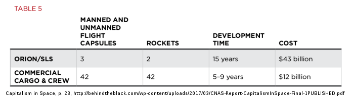
The result was my 2017 policy paper, Capitalism in Space: Private Enterprise and Competition Reshape the Global Aerospace Launch Industry. In it I reviewed and compared what NASA had been getting from its parallel rocket programs, the government-designed and owned Space Launch System (SLS) rocket versus the privately-designed commercial rockets of SpaceX and Orbital ATK (now part of Northrop Grumman). That review produced this very simple but starkly revealing table:
From this data, combined with my extensive knowledge as a historian of American history and culture, resulted in the following fundamental recommendations:
» Read more


