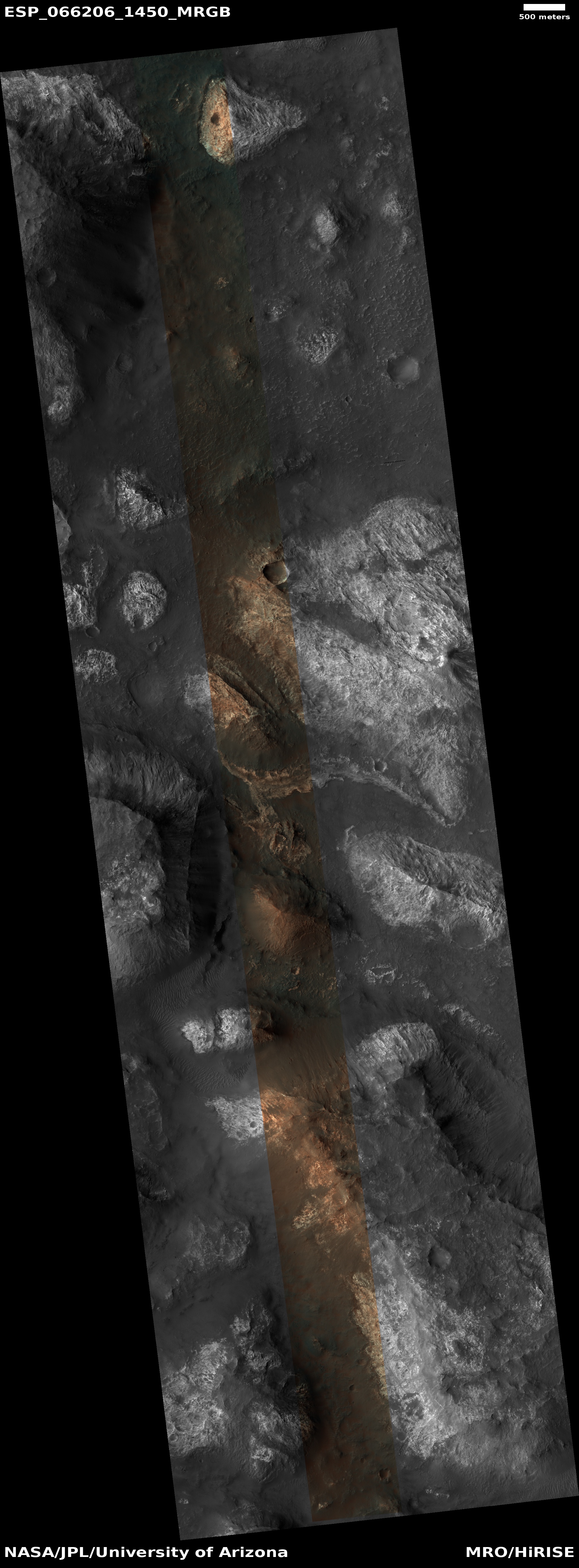
The colorful and bright knobs of Ariadnes Colles on Mars

Colorful and bright knob in Ariadnes Colles
Click for full image.

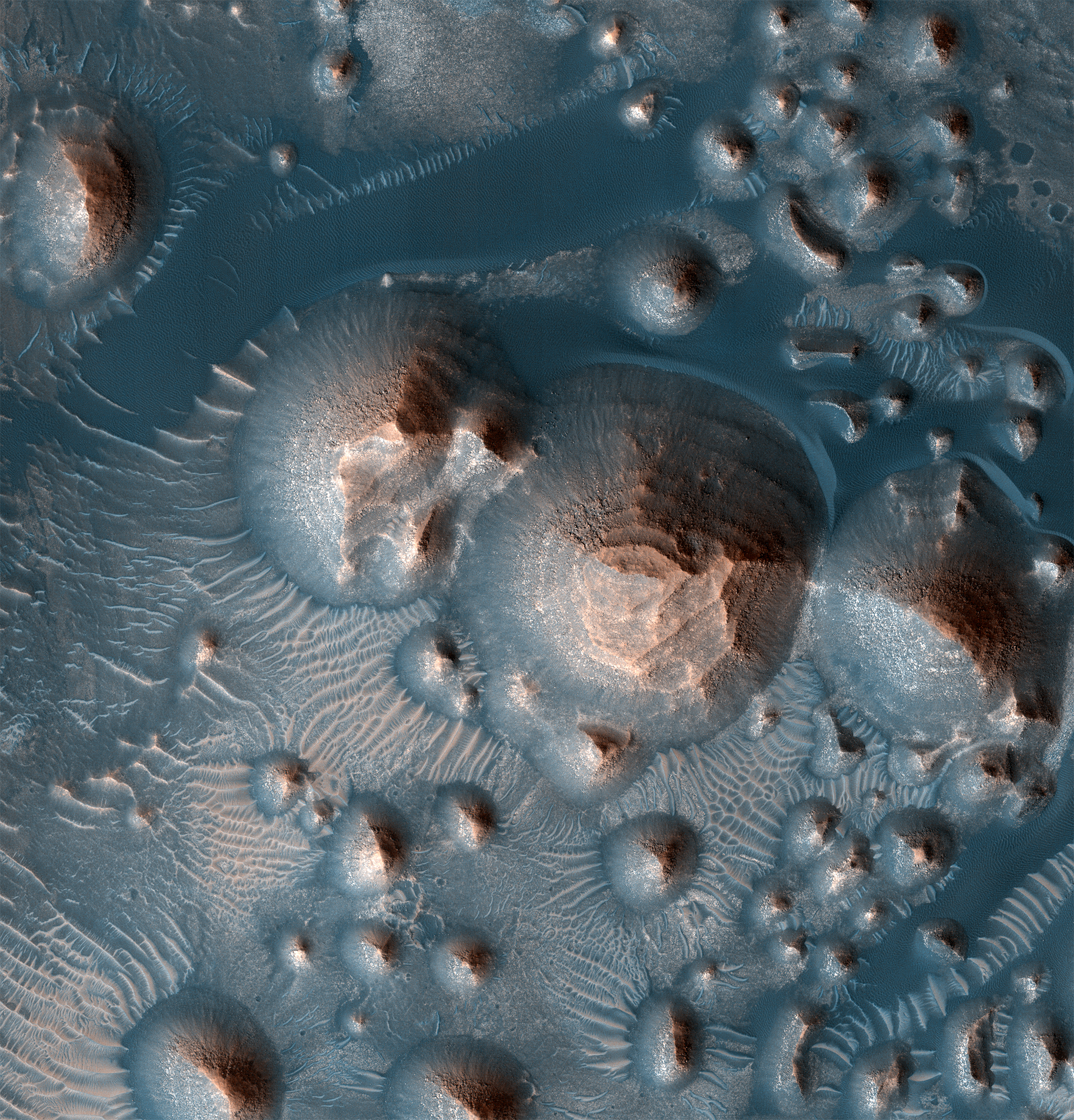
Today’s cool image gives us a sample of the strange colorful hills in an even stranger knobby depression on Mars called Ariadnes Colles. The photo to the right, cropped and color enhanced to post here, was taken on September 10, 2020 by the high resolution camera on Mars Reconnaissance Orbiter (MRO). It focuses on just one of those colorful hills. The color strip only covers the western half, which is why that is the only part of the hill in color.

Ariadnes Colles is a patch of chaotic terrain 110 by 100 miles in size, located in the southern cratered highlands due south of Mars’s volcano country, at latitude 34 degrees south. What makes this particular patch of chaos distinct from the many others on Mars is that the hills, knobs, and mesas within it are routinely bright and colorful, compared to the darker surrounding terrain. Moreover, as noted in this Mars Express press release for images of Ariadnes Colles from that orbiter,

In contrast to other chaotic terrains … Adrianes Colles is not a water-source region. It is still debated, therefore, whether Ariadnes Colles was formed by the action of water or wind.

The darker material in the southern areas is most likely sand or volcanic ash; some slopes of the flat-topped features have been covered by this dark material that was blown up on the slopes.

The sand or volcanic ash most likely come from the Medusae Fossae Formation several hundred miles to the north, the largest volcanic ash deposit on Mars. The colors on the hill likely come from a variety of minerals.

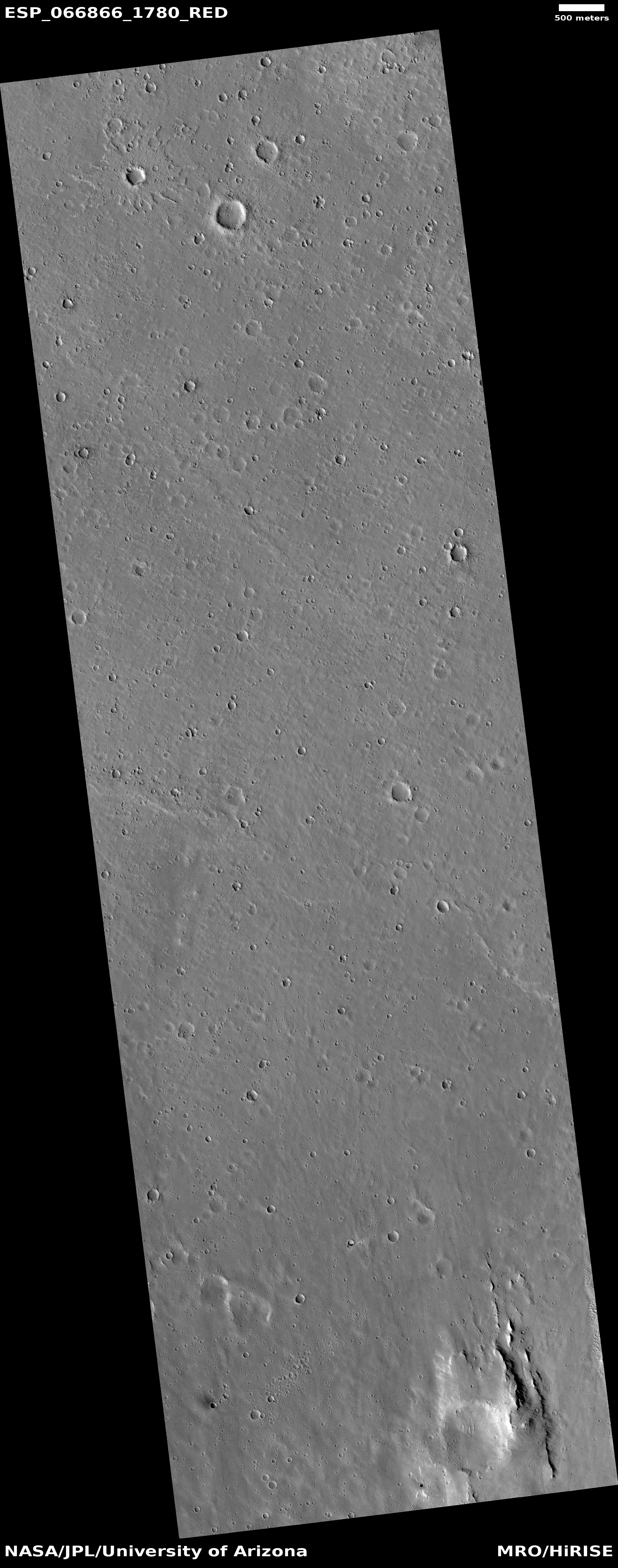
The overview map below shows the entire patch, with the location of the hill above indicated by the white dot in the red rectangle that shows the full image location.
» Read more

1 comment

Partly engulfed Martian craters

An engulfed crater on Mars
Click for full image.

Cool image time! The photo to the right, rotated, cropped, and reduced to post here, was taken by the high resolution camera on Mars Reconnaissance Orbiter (MRO) on October 31, 2020. It shows a crater that appears buried in a sea of material so that pretty much the only thing visible is top of its rim.

The full image shows a second larger crater to the northwest that looks the same. In both cases the material fills the craters also fills the surrounding terrain.

Yet, both craters appear to be surrounded by a faint skirt of uplifted material.

What caused this situation?
» Read more

1 comment

Rover update: Curiosity on the shore of a sand sea

Curiosity stops on the shore of a sand sea, while Yutu-2 continues its journey west away from Chang’e-2. On the way: Perseverance and China’s first Mars rover on Tianwen-1.

A sand sea on Mars
Click for full image.

Curiosity

The photo on the right, taken in late December, shows the large sand lake the science team has labeled “the Sands of Forvie” that the rover has been working its way uphill to reach since it left the Mary Anning drill site back in November.

Since they arrived there, they have used the rover to roll across the sand, cutting into a ripple to expose its interior, followed by high resolution close-up images. They have also used the rover to analyze the chemical composition of the sand’s grains, from that interior section, from the top of several ripples, and from the troughs in between.

Once finished here, the rover will be turned east again to continue its journey around this sand sea to the very base of Mount Sharp. The overview map below shows the planned route.
» Read more

0 comments

A glacier filled canyon on Mars?

Large glacial flow exiting Mamers Valles
Click for full image.

The photo to the right, rotated, cropped, and reduced to post here, was taken on September 9, 2020 by the high resolution camera on Mars Reconnaissance Orbiter (MRO). It shows the northern half of a 15-mile wide canyon on Mars whose floor appears to be completely filled by a glacier. The full picture shows both the north and south rims, and captures the canyon’s outlet from the southern cratered highlands into the chaotic terrain of Deuteronilus Mensae, the region of Mars I like to call glacier country. This region of canyons and mesas forms the transition zone down to the northern lowland plains, and is a region where almost every MRO image shows glacial-type features.

The size and age of this glacial feature is what makes it stand out. First, note the craters on its surface. The glacier has to be quite old and inactive for a long time for those craters to still exist as they appear. Any movement would have distorted them, and they show little distortion.

The overview map below gives a sense of this glacier’s size.
» Read more

0 comments

Summer at the Martian south pole

Overview of the Martian south pole

Today we have two cool images, both giving us a tiny glimpse at what it is like in the middle of summer on the fringes of Mars’ south pole ice cap. Their location is indicated by the blue crosses on the overview map on the right.

To review, the south pole on Mars is, like its north pole, mostly made up of a permanent icecap of water. In the south, this icecap is mostly mixed with dust and debris in the area outlined in black and dubbed the layered deposits. On top of this is a smaller thick water ice cap, indicated by light blue, which is in turn topped by a thin cap of frozen carbon dioxide, or dry ice, indicated by white. During the winter the entire pole, down to 60 degrees latitude also gets covered by a temporary mantle of dry ice, that sublimates away each spring.

Now for our cool images!
» Read more

0 comments

The seas of Titan, deep and alien

Radar track through the estuaries of Titan's large sea, Kraken Mare

The uncertainty of science: In a new paper scientists have taken the radar data from the more than 120 fly-bys by Cassini of Titan to map out the estimated depths for several of Titan’s seas, using that data to also better constrain the make-up of those seas. From their abstract:

Our analysis reveals that the seafloor at the center of Moray Sinusโ€”an estuary located at the northern end of Kraken Mare, is up to 85 m deep. The radar waves are absorbed to an extent such that the liquid composition is compatible with 70% methane, 16% nitrogen, and 14% ethane (assuming ideal mixing). The analysis of the altimetry data in the main body of Kraken Mare showed no evidence for signal returns from the sea floor, suggesting the liquid is either too deep or too absorptive for Cassini’s radio waves to penetrate. However, if the liquid in the main body of Kraken Mare is similar in composition to Moray Sinus, as one would expect, then its depth exceeds 100 m.

The image above, cropped and reduced to post here, is figure two from the paper. » Read more

5 comments

Striped dunes in crater on Mars

Striped dunes in crater on Mars
Click for full image.

Cool image time! The photo on the right, rotated, cropped, and color-enhanced to post here, was taken by the high resolution camera on Mars Reconnaissance Orbiter (MRO) on October 1, 2020. It shows some large dunes with what appear to be black or dark features across their surface, reminiscent of tiger stripes.

The dunes are located on the floor of 42-mile-wide Kunowsky Crater, located in the northern lowland plains of Mars at the high mid-latitude of 57 degrees north.

What are the tiger stripes? The second image below, provided at the image link, zooms in at full resolution at the area in the white box, and shows that the stripes appear to actually be made up of spots strung together.
» Read more

3 comments

A Martian polliwog

Three-mile-wide crater with exit breach
Click for full image.

Cool image time! The photo to the right, rotated, cropped, and reduced to post here, was taken on September 30, 2020 by the high resolution camera on Mars Reconnaissance Orbiter (MRO).

It shows one half of what scientists have dubbed a pollywog crater, in which there is a single breach in the crater wall, aligned with the low point in the crater’s floor. Such craters suggest that they were once water- or ice-filled, and that they drained out through the breach either quickly in a single event or slowly over multiple events.

The second image below was taken by the wide angle context camera on MRO, and not only shows this entire crater, but several other adjacent craters, all of which show evidence of glacial fill in their interiors. The latitude here is 34 degrees south, placing these craters within the mid-latitude bands where such glacial features have been found by scientists in great numbers.
» Read more

4 comments

Terraced mesas in Martian crater

Terraced mesa in Martian crater
Click for full resolution image.

The cool image to the right, reduced and annotated to post here, was a captioned photo released by the Mars Reconnaissance Orbiter (MRO) science team earlier this week. Taken by MRO’s high resolution camera, it shows in color a beautifully stair-stepped mesa located in an unnamed 22-mile-wide equatorial crater in Arabia Terra, the large transitional zone between the lowland northern plains and the southern cratered highlands. As the caption notes,

Several craters in Arabia Terra are filled with layered rock, often exposed in rounded mounds. The bright layers are roughly the same thickness, giving a stair-step appearance. The process that formed these sedimentary rocks is not yet well understood. They could have formed from sand or volcanic ash that was blown into the crater, or in water if the crater hosted a lake.

If volcanic ash, the layers are signalling a series of equal eruptions of equal duration, which seems unlikely. Water is also puzzling because of the equatorial location. Like yesterday’s mystery cool image, water is only likely here at a time when the red planet’s rotational tilt, its obliquity, was much higher, placing this at a higher latitude than it is today.

Regardless, make sure you look at the full image here. This crater floor is chock-full of more such terraced mesas, some of which are even more striking than the sample above.

I have also posted below the MRO context camera photo of the entire crater.
» Read more

5 comments

A splat on Mars

A splat on Mars
Click for full image.

Cool image time! The photo to the right, cropped to post here, was taken on October 31, 2020 by the high resolution camera on Mars Reconnaissance Orbiter (MRO). Labelled simply as a “Terrain Sample”, it was not taken as part of any specific science research but because the MRO science team need to regularly take pictures to maintain the camera’s temperature. When such engineering images are required they try to pick spots of some interest, but sometimes the resulting picture is somewhat bland.

If you look at the full image, you will see that blandness generally describes it. However, in the upper left corner was a most intriguing-looking crater, which I have focused on above. From all appearances, when this impact happened the ground was quite soft, almost like mud, and thus the ejecta splattered away not as individual rocks and debris but as a flow.

The map below gives a little context, but really doesn’t explain this crater fully.
» Read more

5 comments

Cones on Mars!

Today’s cool image is actually a bunch, all found recently in the monthly image download from the high resolution camera on Mars Reconnaissance Orbiter (MRO).

All the photos I post below show pimple-like cones, all of which appear to be a type of small volcano. The cones are found in a wide range of locations, from the northern lowland plains to the cratered highlands to the mid-latitude transition zone between the two. They are also found at the bottom of deep canyons, in the floors of craters, and amidst mountains.

Let us begin.
» Read more

2 comments

Ancient and recent volcanoes on Mars

Volcanic vent on eastern flank of Olympus Mons
Click for full image.

Cool image time! The photo to the right, rotated, cropped, and reduced to post here, was taken by the high resolution camera on Mars Reconnaissance Orbiter (MRO) on October 25, 2020. It shows what it calls a “possible volcanic vent east of Olympus Mons”.

Is this active? If not, how old is it. Also, the elongated shape of the vent suggests the possibility of a lava tube, or at least some underground complexity to the release of its magma.

In order to get some clarity, I emailed Sarah Sutton of the Lunar and Planetary Laboratory of the University of Arizona, who requested this photograph. Her response:

The image is of a small shield volcano with an elongated vent at the summit. We donโ€™t have complete stereo here yet, so we canโ€™t tell exactly what the height is. This vent might have sourced tube-fed flows, but in this case, we canโ€™t resolve such features in the image data. This and other small shield volcanoes in the vicinity are partially buried by plains-forming lava flows. The lava flows around the base overlap the flows that emanate radially from the summit vent. Therefore we infer that the shield is older than the surrounding lava flows.

The vent, which runs from the southwest to the northeast, sits on top of a sloping wide hill, which is that small shield volcano described by Sutton. The flat plains surrounding this hill are from later eruptions from other and possibly larger volcanoes. The wider overview map below might give us a clue as to the source.
» Read more

1 comment
1 101 102 103 104 105 157