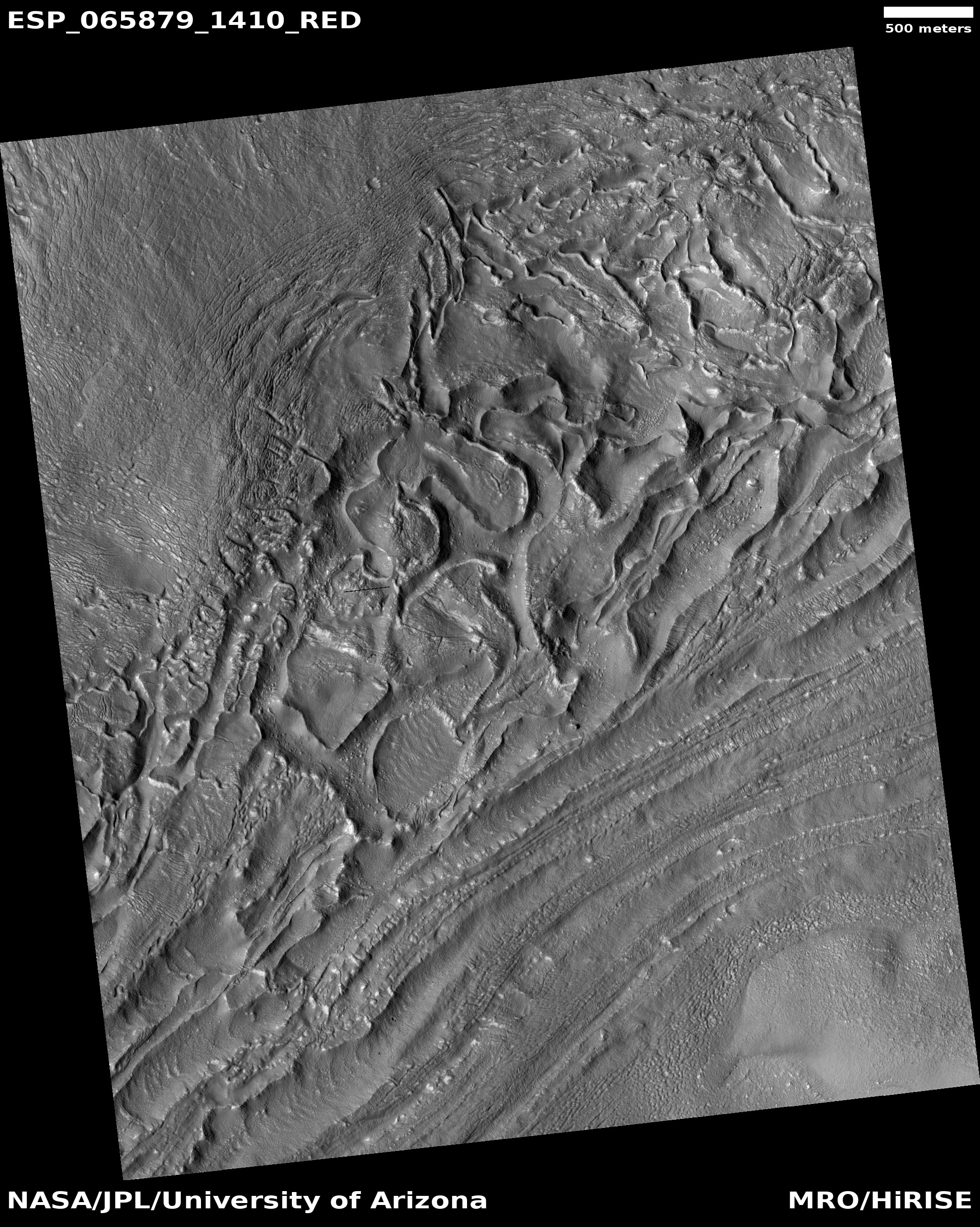
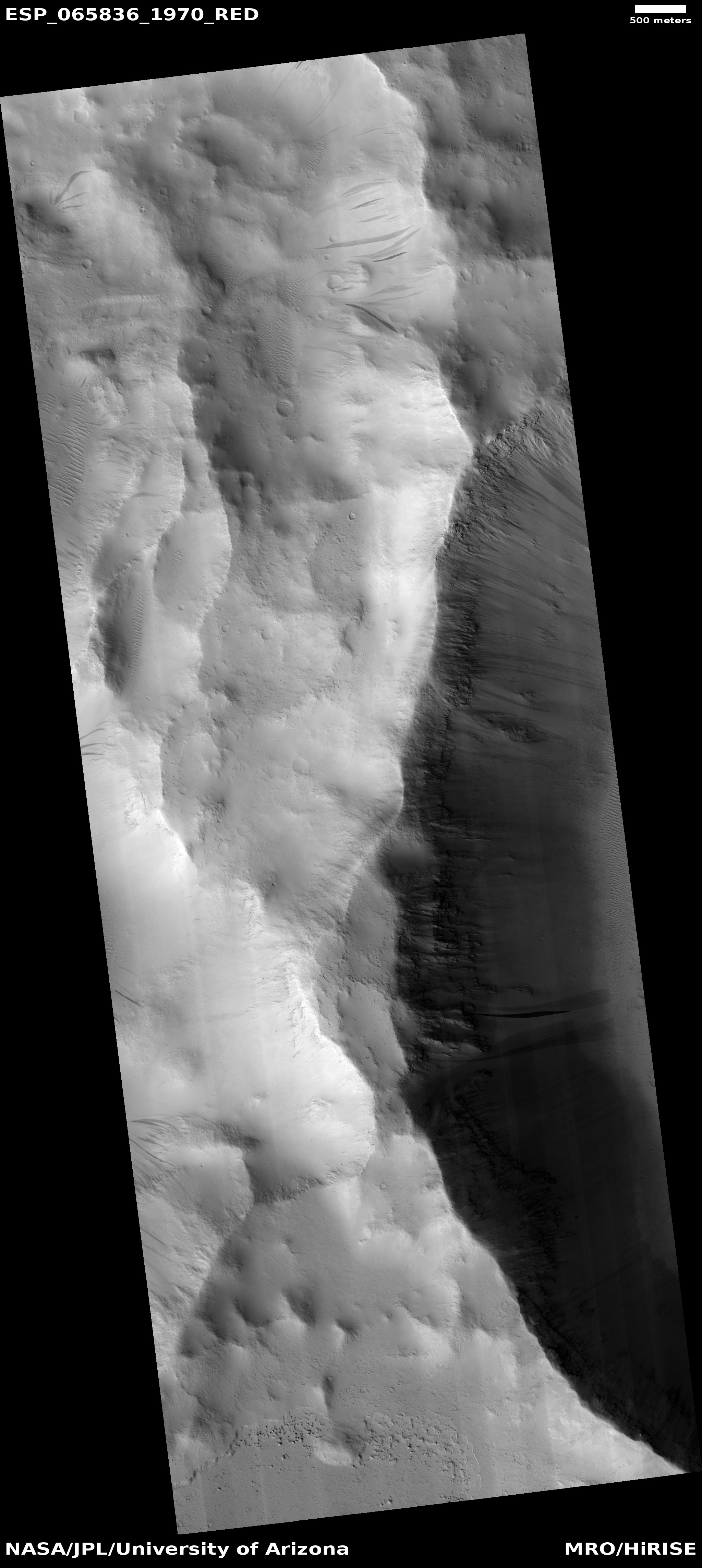
Sagging cliffs on Mars

Sagging escarpment on Mars
Click for full image.

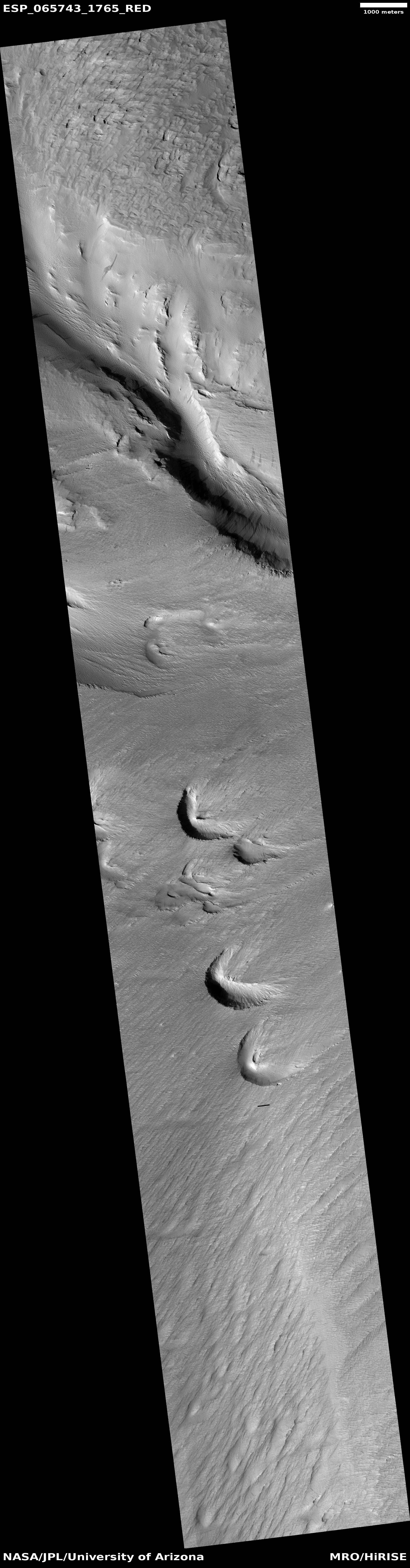
Cool image time! On Mars things change, but not like on Earth because the atmosphere is not as thick and there is no flowing water. The photo to the right, rotated, cropped, reduced, and annotated to post here, gives a good example of that slow change. The image was taken on August 29, 2020 by the high resolution camera on Mars Reconnaissance Orbiter (MRO), and shows the high escarpment that in this one place separates the planet’s southern cratered highlands from the transition zone down to northern lowland plains.

In this spot that escarpment, approximately 4,000 feet high, shows signs of avalanches and sagging. In the upper steep section, I point to what looks like a dust avalanche that wiped the slope clear of rough terrain as it rolled downhill. At the bottom of the cliff a large section has separated away. Since this cliff is located at 28 degrees north latitude and is in the midst of the chaos terrain regions I like to dub glacier country, it is very possible that this large section is actually buried glacial ice that in shifting down slope cracked, separating the lower section from the upper.

This particular location is east of an area dubbed Nilosyrtis Mensae (where there is a lot of evidence of glaciers and frozen ice), and about 650 miles north of Jezero Crater, where the rover Perseverance will land on February 18, 2021.

0 comments

A spray of Martian meteorites

A spray of small secondary impacts
Click for full image.

Cool image time! The photo to the right, cropped and reduced to post here, was taken on October 26, 2020 by the high resolution camera on Mars Reconnaissance Orbiter (MRO). It is what the camera team calls a “terrain sample,” meaning it was not specifically requested by a researcher but was instead chosen by the camera team because they need to regularly take images to maintain the camera’s temperature. When they do this, they try to pick a location that hasn’t been photographed in high resolution previously, and that might have some interesting features. Sometimes the photo is boring. Sometimes they hit pay dirt.

In this case, the photo captured an small impact crater, about 1,300 feet across, surrounded by a spray of secondary impacts. The color portion of the image shows what I suspect are dust devil tracks cutting across a surface that, because of its blue tint, is either rough or has frost or ice within it. At 48 degrees north latitude, the possibility of the latter is high, especially because this location is northwest of the Erebus mountains, where SpaceX has its prime Starship candidate landing zone and where scientists suspect ice is readily available very close to the surface. The overview map below shows this context.
» Read more

2 comments

A place on Mars where lakes, snowfall, and rivers once existed

Inverted channels near Juventae Chasma
Click for full image.

Cool image time! The photo to the right, cropped and enhanced to post here, attracted my immediate interest when I was going through the November image dump from Mars Reconnaissance Orbiter (MRO) because of its meandering sharp ridges, estimated to be about sixty feet high on average. While I have previously posted MRO images of inverted channels such as these, their particular sharpness, plus their large number in this localized single image, aroused my curiosity. What is their history? Does this illustrate an particularly interesting place on Mars?

The picture itself was taken was on September 29, 2020 by MRO’s high resolution camera. The blue areas in the color strip probably indicate coarser-grained surface. This makes sense, as these ridges are believed to have been initially carved as channels by flowing water or ice, which compressed their riverbed and thus made it resistant to erosion. Over time, the surrounding terrain eroded away, leaving that channel behind now as a upstanding ridge. The surrounding eroded terrain should thus be expected to be rougher.

Where did the water for these rivers come from, however? As always, the overview maps below give the context, and a possible explanation.
» Read more

2 comments

Eroded and possibly wet Lohse Crater

Gully flow near central peak of Lohse Crater on Mars
Click for full image.

Cool image time! Today we take a look at one particular 100-mile-wide crater, Lohse Crater, located in the southern cratered highlands on Mars. The photo to the right, cropped and reduced to post here, focuses in on one of the many eroding gullies found in the mountainous region surrounding the crater’s central peak. Taken on August 20, 2020 by the high resolution camera on Mars Reconnaissance Orbiter (MRO), the full image is centered on that central peak, just off the south edge of this cropped section. This new image is part of a long monitoring campaign, begun in 2007, of this central peak region. For more than six Martian years, scientists have been tracking the numerous gullies found throughout the central peak region to see if there have been any changes.

I focused on this specific gully because I think it illustrates well why planetary scientists are monitoring these gullies. Whatever flowed down from the cliff on the left hit the material on the right hard enough and fast enough to imprint a curve into the material on the crater floor. Moreover, it does not appear to have simply been a landslide, for several reasons. First, the cliff does not appear cut back at the flow’s head, as you would expect if a section had broken off. Second, the material in the flow does not look like debris from an avalanche. In fact, there does not appear to be very much debris in the gully at all.

Third, and most important, the flow appears to originate at the cliff base, kind of what you’d expect if there was seepage coming out of a layer in that cliff face. Kind of what you’d expect on Earth, at a spring!

Was that flow water? This is the big question. Lohse Crater is significant in that it was one of the first locations on Mars [pdf] spotted by Mars Global Surveyor in the late 1990s where gullies were found suggesting some form of regular erosion possibly caused by flowing water. As this 2005 paper then concluded,
» Read more

3 comments

Giant wind eddies in the sands of Mars

Wind eddies on Mars
Click for full image.

Cool image time! The image to the right, cropped and reduced to post here, was photographed by the high resolution camera on Mars Reconnaissance Orbiter (MRO) on August 5, 2020. It shows a cluster of the crescent-shaped gullies, apparently carved from desert sand by the prevailing winds.

Those prevailing winds here are from the southwest to the northeast. As the wind blows the sand to the east, it hits a more solid object, such as a mountain buried in the sand, which forces the wind and the blown sand to go around, much as water passes a boulder in river rapids. That solid object also causes an eddy to form at its face, the wind forced downward and then around and up, carving out the gullies by lifting the sand at the base of that solid object. The result are these crescent gullies, dubbed blow-outs.

The overview map helps explain why there is so much sand here, enough apparently to bury whole mountains.
» Read more

3 comments

Glacial eddies on Mars?

Glacial eddies on Mars?
Click for full image.

Cool image time! The photo to the right, cropped and reduced to post here, was taken on August 15, 2020 by the high resolution camera on Mars Reconnaissance Orbiter (MRO). It shows a truly strange bunch of blocks beside a clean flow neatly organized in almost straight parallel lines.

What is going on? This location is at 38 degrees south latitude, a latitude where scientists have found a lot of features that resemble water ice glaciers, generally protected from sublimating away by a thin layer of dust and debris.

A first guess is that the smooth glacial flow at the lower right is disturbing the glacial material next to it, causing it to rip apart and break up. At the same time, the hollowed look of these glacial blocks suggests that the ice below that protective debris layer is also slowly sublimating away, causing the surface to sink.

The wider shot below helps confirm this impression.
» Read more

0 comments

Frost on a Martian hillside

Frost on Martian hillside
Click for full image.

Cool image time! The image to the right, cropped to post here, was taken on August 27, 2020 by the high resolution camera on Mars Reconnaissance Orbiter (MRO). It shows a flat-topped mesa in an enclosed canyon dubbed Sisyphi Cavi in the high southern latitudes of Mars during the spring.

Notice the white spots in the gullies on the southern-facing slopes? From what I can gather from a bit of research, these indicate the presence of carbon dioxide frost. It was spring at this location when the photo was taken. At that time, the thin seasonal mantle of dry ice that covers Mars’ the polar regions south to 60 degrees latitude in the winter is sublimating away. This would explain why the frost is only present in the south-facing slopes. Since this is in the southern hemisphere, the south-facing slopes get much less sunlight, and would sublimate away later.

The photo was taken as part of a monitoring program to study this sublimation process. According to this abstract:

Superposition of channel features over and/or through the defrosting CO2 snowpack shows that the channels are active at the present day and probably have fluid flows every spring during the annual defrosting. In itself, this is a significant observation as active fluid flows of any nature have not yet been proven on Mars. However, the ambient temperature at the time of gully activity appears to require a role for CO2 in the formation of the channels, rather than water.

In other words, the coming and going of this dry ice frost each Martian year, in conjunction with the underground water ice also found here, appears to be causing erosion that then creates of the gullies themselves. More details from the abstract in this paper:
» Read more

0 comments

Buried mountain on Mars

Isolated buried mountain on Mars
Click for full image.

Cool image time! The photo to the right, rotated, cropped, and reduced to post here, was taken on August 8, 2020 by the high resolution camera on Mars Reconnaissance Orbiter (MRO). Labeled merely as a “terrain sample,” it is an example of an image taken more for engineering than scientific reasons. No research scientist specifically requested it. Instead, the scientists operating the camera took it because they need to use MRO regularly to maintain the camera’s proper temperature. To do this they periodically take almost random images, but never without trying to pick a location that might have some scientific value.

In this case we get what appears to be an isolated sloping hill. Located at about 15 degrees north latitude, this is not a place where one would expect visible evidence of water, though the gullies on the slopes are intriguing. They almost look like the kind of hillside erosion you see in places where rain falls on desert mountainsides.

Rain can’t be the cause, but nonetheless monitoring these gullies for changes over time would be worthwhile science research. Since it appears no one is presently focused on doing it, anyone interested out there?

This mountain is actually far more isolated than this high resolution image suggests.
» Read more

8 comments

A majestic terraced butte on Mars

Majestic butte on Mars
Click for full image.

Cool image time! The photo to the right, rotated, cropped, and reduced to post here, was taken on September 8, 2020 by the high resolution camera on Mars Reconnaissance Orbiter (MRO). It shows an outstanding terraced butte that would rival any of the similar buttes scattered throughout the Grand Canyon, and is reminiscent especially of Wotans Throne.

What makes this butte intriguing are its terraces, the obvious result of the repeated deposition of new layers across the surface over time, and now exposed by erosion. What caused them?

As always, location provides the clues. First, this butte is found at about 15 degrees north latitude in the vast Arabia Terra transition region between the Martian northern lowland plains and the southern cratered highlands. At that latitude, we are not looking at any recent glacial features. While there might have been ice here once, it hasn’t likely been present, either on the surface or underground, for a very long time.

This conclusion becomes important once we look at the wider photo below, taken by the high resolution camera on the European orbiter Mars Express. This image gives us the immediate context.
» Read more

0 comments

A field of Martian knobs

Knob field on Mars
Click for full image.

Cool image time! The photo to the right, cropped and reduced to post here, was taken on August 9, 2020 by the high resolution camera on Mars Reconnaissance Orbiter (MRO). Uncaptioned, the image is merely dubbed a “knob field.”

I won’t spend much time trying to explain this geology. It might be related to pedestal craters, but these ridges and mesas don’t really look like those features, since they don’t really stand above the surrounding terrain.

Maybe they are a very ancient field of craters long buried, now partly exposed due to erosion, but also partly buried by wind-blown Martian sand and dust. Once again, that many of their shapes don’t resemble craters discounts this explanation.

The location of this photo is in the southern cratered highlands, as shown by the black cross in the overview map below.
» Read more

0 comments

Terraced mesa inside Martian depression

Terraced mesa inside depression
Click for full image.

Cool image time! The photo to the right, cropped and reduced to post here, was taken on July 1, 2020 by the high resolution camera on Mars Reconnaissance Orbiter (MRO). It shows a very puzzling terraced mesa inside an enclosed depression or sinkhole (the western half of which can be seen in the full image).

What caused that mesa? A first scan of the image and the data suggests we are looking at sinkage related to the melting of an underground ice table. The latitude here is 34 degrees south, just far enough away from the equator for glacial activity to be possible. Moreover, the small circular depression in the upper right of the image strongly suggests an impact crater into slushy material. The implication is that this depression is the result of the melting or sublimation of underground ice, leaving behind a mesa that is made of solider stuff.

Another possibility is that the terraced mesa is actually the remains of glacial material. In the full image features inside other nearby depressions are terraced also, but are also much more reminiscent of glacial features found in many craters in the mid-latitudes. The depression is also close to the headwaters of Reull Valles, a meandering canyon where many images have shown glacial features (see for example here, here, and here).

These features however could also have nothing to do with water ice.
» Read more

0 comments

Why Martian mountains are different than on Earth

A mountain peak on Mars
Click for full image.

Cool image time! The photo to the right, rotated, cropped, and reduced to post here, was taken on August 12, 2020 by the high resolution camera on Mars Reconnaissance Orbiter (MRO). It shows what to any Earthling’s eye appears to be a somewhat ordinary flat-topped mountain peak with two major flanking ridgelines descending downward to the north and the south, and two minor ridgelines descending to the northwest and southwest.

This peak and its landscape would surely be quite a spectacularly place to visit, should humans ever settle Mars and begin doing sightseeing hikes across its more interesting terrain. I can definitely imagine hiking trails coming up the two minor ridges, with a crest trail traversing the main north-south ridge across the peak.

This is not however a mountain on Earth. It is on Mars, which makes its formation and evolution over time fundamentally different than anything we find on Earth, despite its familiar look.

First, what formed it? Unlike most of Earth’s major mountain chains, the mountains of Mars were not formed by the collision of tectonic plates, squeezing the crust upward. Mars does not have plate tectonics. Most of its mountains formed either from the rise of volcanoes at single hot spots, or from the wearing away of the surrounding terrain to leave behind a peak or mesa.
» Read more

3 comments
1 63 64 65 66 67 90