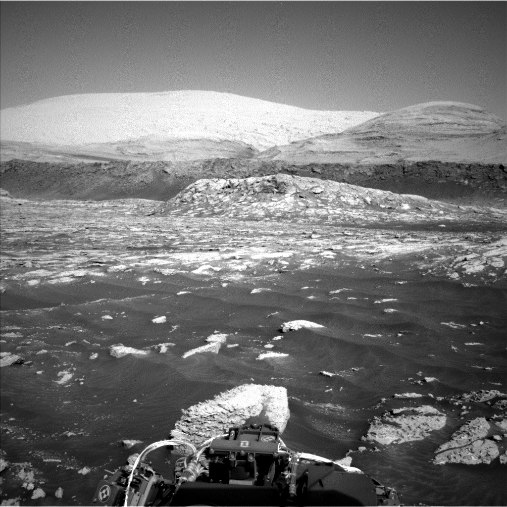
Perseverance begins journey with 1st test drive

Perseverance's future planned route
Click for full image.

On March 4th the engineers on the Perseverance science team successfully completed the rover’s first test drive.

Ground teams commanded the rover to drive forward, turn in place, and then back up. The first 33-minute test drive covered just 21 feet, or 6.5 meters,but Perseverance will soon travel much farther. “Our first drive went incredibly well,” said Anais Zarifian, a Perseverance mobility test engineer at JPL.

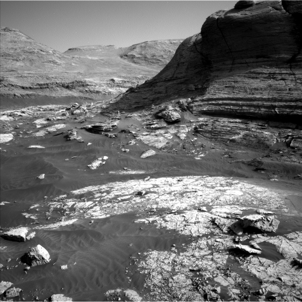
Perseverance has six aluminum wheels, each with titanium spokes for support, and a suspension capable of traveling over rocks as big as the wheels themselves. The one-ton rover is based on the design of NASA’s Curiosity rover, which landed on Mars in 2012, but with some improvements.

The wheels on Perseverance are sightly narrower, have a larger diameter, and are made of thicker materials, Zarifian said. Engineers also changed the tread pattern on the wheels to reduce the risk of damage from sharp rocks, which created dings and cuts in Curiosity’s wheels.

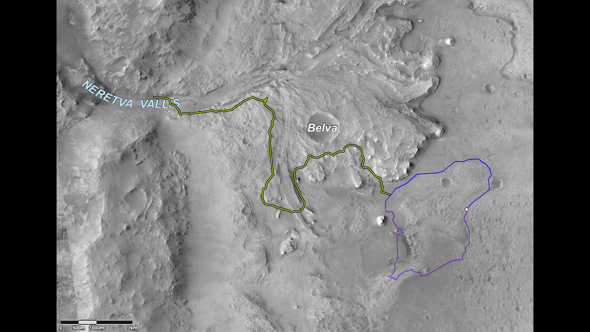
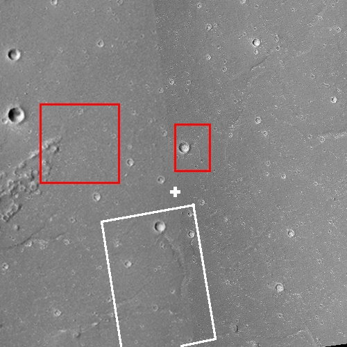
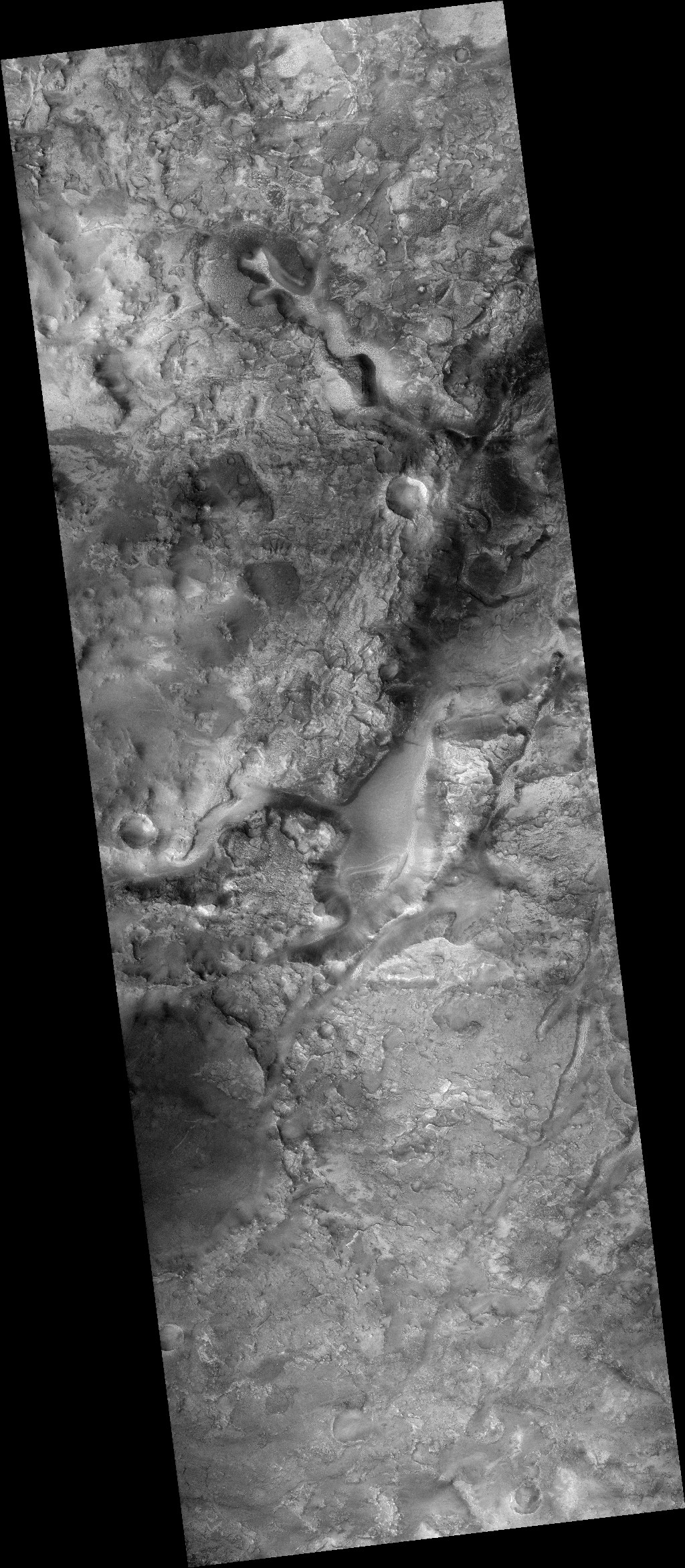
The map above shows the route the science team has presently chosen for Perseverance, a revision from earlier routes created prior to landing. The white dot on the right is the rover’s present position, the blue and purple lines are two alternative routes they are considering for their route to the delta coming out of Neretva Vallis. The yellow route up the delta is especially exciting in that it gets them onto it much sooner than previous plans.

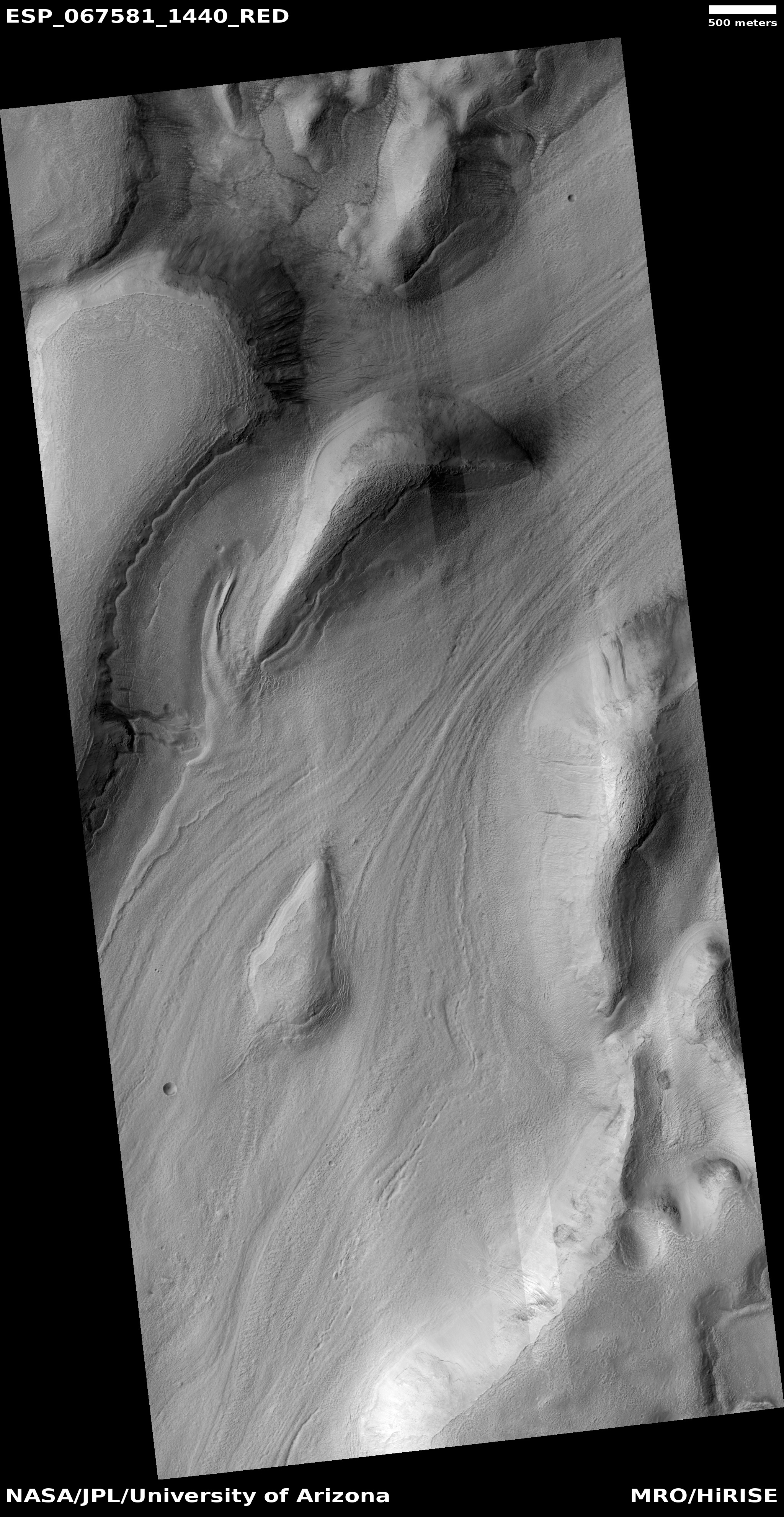
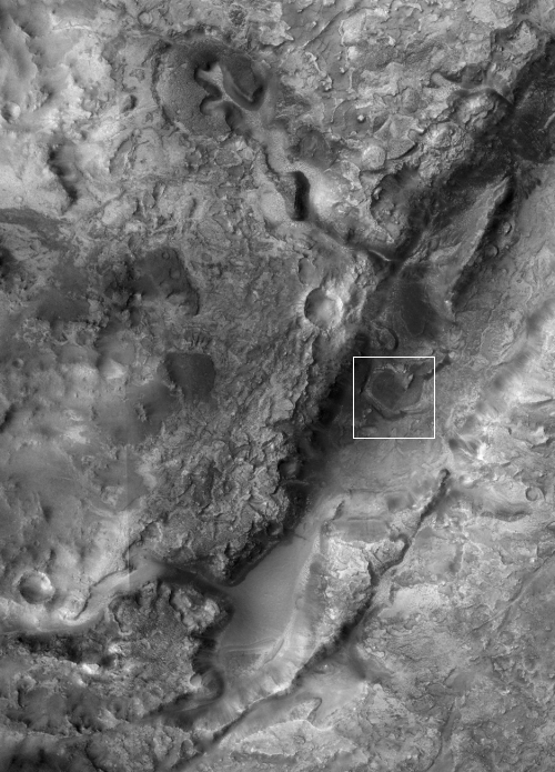
Which route they choose for the initial journey I think will partly depend on which provides the best location to test fly Ingenuity, the experimental helicopter on the rover. Scientists and engineers I am sure are presently poring over high resolution images from Mars Reconnaissance Orbiter (MRO) in order to make that choice. At this link, centered on Perseverance’s present location, you can take a look at all those images by MRO by selecting the arrow icon at the top and then clicking on any red box. Because so many photos have been taken there is a lot of overlap, so each click will give you many pictures to look at.

5 comments

Ice-filled Martian sinkhole

Ice-filled pit on Mars
Click for full image.

Cool image time! The pit shown in the high resolution photo to the right (image rotated, cropped, and reduced to post here) was taken on January 25, 2021 and labeled by the Mars Reconnaissance Orbiter (MRO) “Collapse Pit in Graben with Ice Fill.”

There is a lot of information in that title. First, a graben is a geological feature where a section of terrain drops relative to the surrounding terrain, producing a depression. Second, it appears the graben in this region is mostly filled with debris, probably wind-blown dust or sand or volcanic ash.

Third, at this particular spot the filling material sank, like a sinkhole on Earth, creating the pit.

And fourth, and maybe most intriguing, the scientists think that this pit is now filled with ice. At 47 degrees north latitude, the location is prime for such ice, and the interior material resembles similar glacial features seen in many other mid-latitude craters.
» Read more

2 comments

Rover update: Panorama from Curiosity; Perseverance unwinds

Summary: Curiosity has crept to the foot of Mt Sharp at last, while Perseverance checks out its equipment.

Curiosity

Curiosity panorama Sol 3049
Click for full resolution.

Overview map

This rover update will be short but very sweet. While the press and public has been oo’ing and ah’ing over the first panorama from Perseverance, Curiosity yesterday produced its own panorama above showing the looming cliffs of Mt. Sharp, now only a short distance away. The original images can be found here, here, here, and here.

The overview map to the right, from the “Where is Curiosity?” webpage, shows the rover’s location, with the yellow lines roughly indicating the view afforded by the panorama above. If you compare this panorama with the one I posted in my previous rover update on February 12, 2021, you can get a sense of how far the rover has traveled in just the past two weeks. It now sits near the end of the red dotted line pointing at the mountain, right next to what had been a distant cliff and now is only a short distance to the rover’s right.

Somewhere on the mountain slopes ahead scientists have spotted in orbiter images recurring slope lineae, seasonal streaks on slopes that appear in the spring and fade as they year passes. As Curiosity arrives at the next geological layer a short distance ahead at the base of these cliffs (dubbed the sulfate unit), it will spend probably several months studying both that sulfate unit as well as those lineae. Expect the rover to drill a few holes for samples as it watches to see any changes that might occur on that lineae.

Now, on to Perseverance!
» Read more

0 comments

NASA increases ISS prices to commercial customers by 700%

On February 25th NASA quietly announced that it was increasing the prices it charges for private commercial payloads to ISS sevenfold, immediately putting some customers out of business.

In the statement, published with little fanfare on the agency’s website, NASA said it was updating that price list “to reflect full reimbursement for the value of NASA resources.” The decision to do so, NASA said, was based on “discussions with stakeholders, the current market growth, and in anticipation of future commercial entities capable of providing similar services.”

By removing the subsidy, the prices of those services went up significantly. The cost to transport one kilogram of cargo up to the station, known as “upmass,” went from $3,000 to $20,000. The cost to bring that one kilogram back down from the station, “downmass,” went from $6,000 to $40,000. One hour of crew member time, previously $17,500, is now $130,000.

The sudden change in prices, which took effect immediately, took some ISS users by surprise. An executive with one company, who spoke on background because that company is still evaluating the impacts of the pricing change, was not aware of NASA’s decision to raise prices until contacted by SpaceNews.

“NASA has not done a good job communicating with the stakeholders,” said Jeffrey Manber, chief executive of Nanoracks. “We are in discussions with customers and suddenly we are being notified of a major increase.” That sudden increase in prices, he said, forced Nanoracks to suspend discussions with two potential customers, who he said were “priced out of their budget” by the increase.

Note that NASA’s statement apparently contained a lie. It claimed the agency talked with “stakeholders,” but apparently those stakeholders knew nothing about it until it happened.

I strongly suspect this is a Biden administration decision, not one from NASA. Democratic Party politicians don’t see government as a servant of the people, but as a tool to rule them. A private industry is beginning to sprout using government resources in space, and rather than encourage its growth they instead want to squeeze as much cash from it as possible.

Moreover, why is NASA charging anything for bringing cargo to ISS? They don’t provide the transportation, launch companies like SpaceX and ULA do. The only appropriate charge NASA should be charging is rental at the station.

If this was a NASA decision solely and Trump was in power, I would expect it to be soon canceled. Under Biden there is no chance. More likely that administration either endorsed it or imposed it.

What this means is that future commercial flights will soon shift away from ISS. I expect Axiom to work hard to get its station modules launched and separated from ISS as quickly as possible. I also expect to see more independent Dragon manned tourist missions, like the one planned for this fall, that do not dock with the station.

In fact, here is a thought that I think has already entered Elon Musk’s brain. In the next year SpaceX is likely going to do its first Starship orbital test flight. Why not put a test habitable module on board that can be used by tourists at a reasonable price? There is money to be made here, especially because NASA is gouging its customers and there is plenty of margin to undercut the agency’s absurd prices.

35 comments

Virgin Galactic’s chairman sells all of his stock in the company

Getting out when the getting is good: The chairman of Virgin Galactic who was part of the deal that allowed the company to go public has now sold all of his stock in the company.

Billionaire investor Chamath Palihapitiya sold his entire personal stake in Virgin Galactic this week, a regulatory filing revealed on Friday.

The space-tourism company’s chairman cashed out his 6.2 million shares at an average price of $35, netting him around $211 million. Palihapitiya, along with his business partner Ian Osborne, still indirectly own 15.8 million shares via SCH Sponsor Corp, their investment vehicle.

Palihapitiya previously sold 3.8 million Virgin Galactic shares in December, tweeting that he needed to free up cash to fund several new projects this year.

Like Branson, this guy took the company public, made some absurd claims about its future, got several Wall Street analysts to rave about his plans, and then when the stock was high because of these fake promises, got out. He knows, as did Branson, that Virgin Galactic has practically a zero chance of making a dime in the future. He just worked a con to use it to make him some cash on the backs of a lot of other stock buyers who should have known better.

This company might fly a few paying customers on some suborbital flights, but its long term future is very bleak.

7 comments

Dao Vallis: A giant river of ice on Mars

The glacier in Dao Vallis
Click for full image.

Cool image time! The photo to the right, rotated, cropped, and reduced to post here, was taken on December 26, 2020 by the high resolution camera on Mars Reconnaissance Orbiter (MRO). It shows an apparent glacial flow in a canyon heading downhill to the southwest, with evidence of a gully on its western wall whose collapse apparently squeezed into that glacial flow, pushing it to the east.

What makes this particular image interesting is not its uniqueness but just the opposite. Almost every high resolution picture along the length of this 750 mile long canyon, dubbed Dao Vallis, shows the same thing, an ice-filled ravine with that ice flowing like a river downhill.

The overview map below provides some spectacular context.
» Read more

4 comments

China releases first Tianwen-1 images of rover landing site

The rover landing site for Tianwen-1's rover

The new colonial movement: China yesterday released the first two images taken by its Mars orbiter Tianwen-1 of its planned rover landing site in the northern lowland plains of Mars.

The image to the right is a mosaic of two wide angle photos from the context camera on Mars Reconnaissance Orbiter (MRO). The white cross is the spot of the latitude and longitude that had previously been leaked to the Chinese press as the landing site. The white box shows the area covered by the only high resolution MRO photo, as of October 2020. Since then MRO has taken a number of additional high resolution images of this area.

The red boxes mark the areas covered by Tianwen-1’s two new images. Below is a reduced version of the larger of these two photos.
» Read more

4 comments

SpaceX launches 60 more Starlink satellites

Capitalism in space: SpaceX last night successfully launched sixty more Starlink satellites, while also recovering the first stage during its eighth flight.

This is the second booster that has successfully completed eight flights. Its flight back to the drone ship appeared entirely routine, though SpaceX provided no footage of that return.

The 2021 launch race:

6 SpaceX
4 China
3 Russia
1 Rocket Lab
1 Virgin Orbit
1 Northrop Grumman
1 India

The U.S. now leads China 9 to 4 in the national rankings.

1 comment

The Starship has landed!

Starship #10 on the ground safely after its flight
After the flight.

Capitalism in space: SpaceX today successfully completed the first test flight of Starship prototype #10, not only completing the launch and descent manuevers but also successfully landing the prototype vertically on the landing pad.

The flight was similar to the previous two in that the spacecraft rose very slowly, hovered at about 6 miles, and then did a flip to place itself horizontal for its descent. Then as it approached the ground it righted itself as it fired up three engines (to make sure at least one worked), and then shut down two so that one engine brought the spacecraft down smoothly.

Next comes prototype #11. Its flight should occur with only a matter of weeks.

Starship #10 exploding
Starship #10 on its way down after exploding.

UPDATE: A few minutes after landing the prototype exploded, flinging itself off the launchpad. No word yet on why this happened, but I wonder if maybe this was a planned self-destruction. They don’t plan to fly this bird again, and it takes up a lot of storage space. Blowing it up saves space, though it does destroy material that could be salvaged for other uses.

To the right is a screen capture from one of LabPadre’s live streams, shortly after the ship launched itself from the pad and was on its way down. It only went up about two hundred feet.

If this wasn’t planned, SpaceX needs to figure out why this happened. Either way, we shall certainly find out in the coming days.

Below is SpaceX’s video of the entire flight. Enjoy!

33 comments

Mining country on Mars?

The southern end of Nili Fossae

Today’s cool image might very well be giving us a glimpse of one of the most promising regions on Mars for future mining. The photo to the right, rotated, cropped, and reduced, is made up of two context camera images from Mars Reconnaissance Orbiter (MRO), found here and here. I chose to begin with this wider context camera mosaic because this is one of the rare times the context camera is more exciting an image than the close-up high resolution photo.

This photo covers the southern end of the one of the two curved fissures dubbed Nili Fossae and are thought to be left over evidence of the giant impact that created Isidis Basin to the southeast. These two fissures are about 300 miles long, and can be as much as 1,600 feet deep in places. At this southern end, we can see what look like at least two different drainage channels feeding into the fissure.

The overview map below provides the context of this location on Mars, including its relationship to Jezero Crater where Perseverance now sits.
» Read more

1 comment

Sunspot update: February activity declines to predicted values

Time to do another sunspot update. Below is NOAA’s March 1, 2021 monthly graph, showing the Sun’s monthly sunspot activity. It is annotated by me as always to show the previous solar cycle predictions.

February continued the decline of sunspot activity seen in January after a very unusually active November and December. Though the actual sunspot number was more than the prediction, the difference in February was trivial.
» Read more

4 comments

Cave boxwork on the Martian surface

Boxwork in Wind Cave on Earth
Boxwork inside Wind Cave, South Dakota, mere inches across.

Anyone who has ever visited either Wind or Jewel caves in South Dakota has likely seen some wonderful examples of the cave formation boxwork, formed when the material in cracks is more resistant to erosion that the surrounding bedrock, which once eroded away leaves behind the criss-crossing ridges seen in the picture to the right.

Today’s cool image provides us what appears to be an example of boxwork on Mars. However, unlike on Earth it is not in a cave but on the surface. It is also much larger. Instead of the ridges being almost paper thin and stretching for inches or feet, this Martian boxwork is feet wide with ridges extending hundreds of feet in size, as shown by today’s cool image below.
» Read more

1 comment
1 98 99 100 101 102 126