Click for full image.
The new colonial movement: Three weeks after its Mars rover Zhurong rolled off its lander to begin its 90 day mission, China yesterday finally released the first high resolution images taken by the rover.
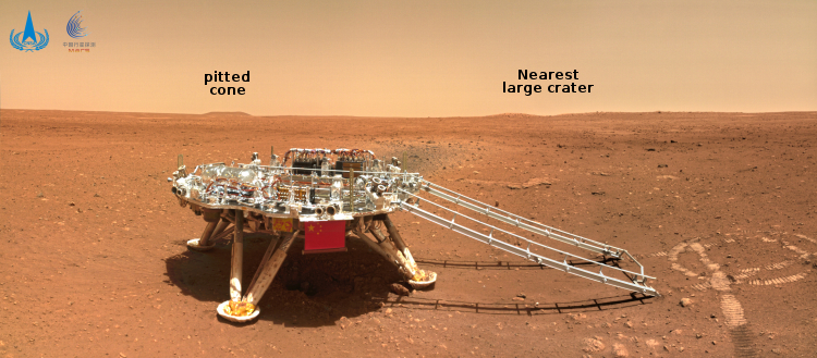
The images included a 360 degree panorama, taken while the rover was still sitting on the lander, an image of both the rover and lander taken by a mini-camera that was dropped from the bottom of the rover, a picture of some interesting nearby boulders to the east, and a picture looking past the lander looking north.
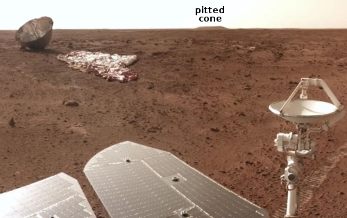
This last picture is above, reduced and annotated by me. The small flat but distinct hill to the north I think is the nearest pitted cone that could be either a mud or lava volcano. That cone is about 3.75 miles away, and though a very enticing target is probably too far away for Zhurong to reach, unless it survives for years past its planned three-month mission, as did the American rovers Spirit and Opportunity.
The closer small ridges and hills just to its right could be the east and west rims of the nearest large crater, about 650 feet wide with a distorted shape, that is visible in the high resolution orbital images taken by both Tianwen-1 and Mars Reconnaissance Orbiter (MRO). This crater is about 1,600 feet away.
Based on these images it appears that once Zhurong rolled off the lander to the east, it immediately turned to the right to move several feet south, where it turned right again to move several feet to the west until it was just to the west of the lander, where it took the picture above. During that last move it dropped the small camera behind it so that it could take the picture showing both the rover and the lander.
These maneuvers and the rover’s position south of the lander and facing west suggest they are going to head to the west, where there are some nearby smaller craters and other interesting features. Whether they eventually go north, with that pitted cone a long term goal should the rover last longer than its planned mission through the end of August, remains entirely unknown.


