A bullseye on Mars

Layered crater at equator
Click for full image.

Cool image time! In researching my piece last week on the glaciers of Mars I had wanted to include a picture of a typical concentric glacier-filled crater, the most widespread glacial feature on the Martian surface, found in a band at latitudes between 30 and 60 degrees. (You can see the example I found at the link above, near the end of the article.)

To find that picture I searched the Mars Reconnaissance Orbiter (MRO) archive. Among the images I found was a captioned image taken very early in MRO’s mission showing a crater with concentric rings very similar to the concentric glacial-filled craters. The image at the right is that crater, the image reduced and cropped to post here. As described in that caption,
» Read more

1 comment

Golfing with boulders on the Moon

Boulder tracks on the Moon
Click for full resolution image.

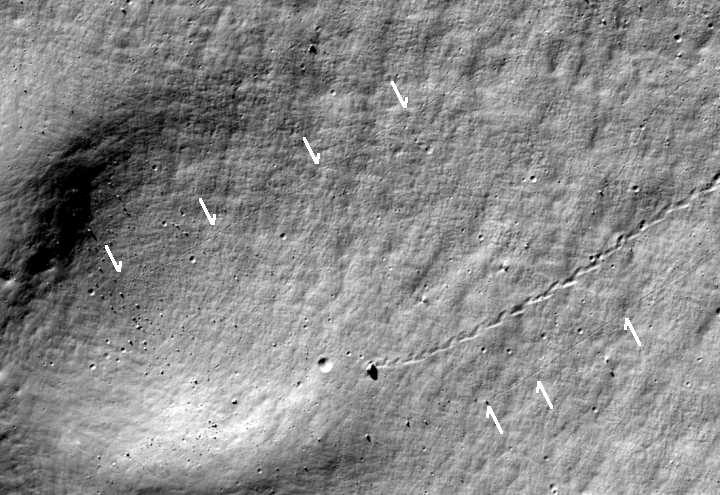
Cool image time! The Lunar Reconnaissance Orbiter team this week released a beautiful image of boulder tracks rolling down the inside slope of 85-mile-wided Antoniadi crater on the far side of the Moon. The image above, cropped, reduced, and annotated to post here, shows these tracks.

The most obvious track is cool because the boulder almost made, as the scientists note, “a hole-in-one.”

Running from the outcrops to the rim of the partially buried crater is a track etched by a rolling boulder bigger than a bus. Perhaps a moonquake shook it loose. The boulder bounced and rolled toward the partially buried crater, plowing a path that is still visible through the loose material of the slope. When it reached the rim of the partially erased crater, its path curved and it slowed to a stop.

…Had it rolled just 75 meters more, the boulder might have plopped neatly into a 30-meter-diameter young impact crater on the floor of the partially erased crater.

The arrows I have added indicate two more less obvious boulder tracks. If you click on the full resolution image and zoom in you can also see another series of impressions in the middle of the photograph that look like a dotted line, suggesting they were left by a boulder bouncing down the slope.

The scattered of boulders in the floor of the small crater all likely came from the top of the big crater’s rim, which I show in the wider image below.

Wider image showing entire crater slope

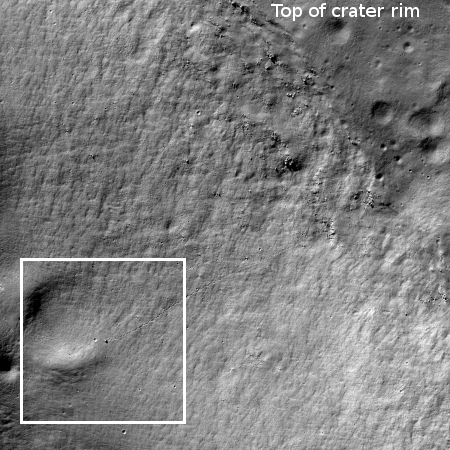
The box indicates the location of the image above.

While many things over the eons could caused these boulders to roll (moonquakes, erosion from the solar wind, other nearby impacts), a close look at the ground surrounding them does not show tracks emanating from most, suggesting they have been there a very long time, long enough for the surface reworking caused by the solar wind to have smoothed those tracks out.

The Moon is airless and mostly dead. The solar wind is incredibly weak. Any changes caused by it will take a lot of time. Consider the time required to smooth out those tracks. The mind boggles.

0 comments

Tsunamis on Mars?

New research has found further evidence of past tsunamis on Mars along the transition zone between the northern lowlands (where an intermittent ocean might have once existed) and the southern highlands, caused when a bolide crashed into that ocean.

The new research simulated the height of the tsunami waves and their propagation direction, run-up elevation and distance for three potential sea levels and compared these models with the Martian deposits.

The studyโ€™s results suggest several potential impact craters, 30 to 50 kilometers (19 to 31 miles) in diameter, as the source of the tsunami events. The largest tsunami waves may have been 300 meters (984 feet) high โ€“ nearly as tall as the Eiffel Tower โ€“ following the impact, and waves up to 75 meters (246 feet) high โ€“ nearly as tall as the Statue of Liberty. The waves ultimately reached the Martian coast, potentially traveling up to 150 kilometers (93 miles) past the shoreline.

Below the fold is a video showing the simulation of one such impact and tsunami.
» Read more

1 comment

A lunar crater wall two miles high

Giordano Bruno crater

Cool image time! Considering this week is the 50th anniversary of the Apollo 11 lunar landing, it seems appropriate to show some cool images from the Moon.

Today the Lunar Reconnaissance Orbiter (LRO) science team released a spectacular oblique image of Giordano Bruno crater. The image on the right is cropped and very significantly reduced to post here. It looks across the crater, with the near rim across the bottom of the picture and the wall of the far rim filling the photograph’s top half.

That wall is what makes this image cool. It is a cliff about 10,000 feet high, equaling almost two miles. Moreover, at its base is a now-solidified melt pool left over from the impact that made the crater.

Faster than a speeding bullet – or rather ten times faster than a speeding bullet – is a good starting point in terms of grasping the energy released in a typical impact event. That is, for a bullet approaching 2 kilometers in diameter! The pressure and heat that were released during the collision not only excavated a hole much larger than the impactor but also melted a tremendous amount the target rock. Melt was sprayed and sloshed on the forming crater walls where much of it flowed back, seeking the lowest point in the impact crater. From the LROC vantage point you can follow the path taken by impact melt as it flowed across the irregular floor, ponding in closed depressions, and some of it ultimately reaching the lowest point.

Below the fold is a much higher resolution section of this photograph, focused on the crater wall and the melt pool. I have still been forced to reduce the resolution somewhat to post it here. Along that cliff wall can be seen partial avalanches (the dark splotch near the center) as well boulder tracks with the boulders (probably larger than most houses) still visible as white spots at the wall’s base.

The scale here is difficult to imagine. This cliff wall is three times as high as The Abyss, the steepest single drop viewpoint along the south rim of the Grand Canyon.
» Read more

2 comments

Exploring with Mars Reconnaissance Orbiter

Terrain sample
Click for full image.

In my never-ending rummaging through the images released each month from the high resolution camera on Mars Reconnaissance Orbiter (MRO), I have sometimes been puzzled by the titles they choose for some photographs. For example, many pictures each month are simply titled “Terrain Sample.” The image to the right, cropped and reduced to post here, is one example, and its content adds to the mystery.

The photograph itself shows a generally featureless surface. Other than the scattering of small craters, there are only very slight topographical changes, the most obvious of which is the meandering ridge to the east of the largest crater.

I wondered why this picture was taken, and why it was given such a nondescript name. To find out, I emailed Veronica Bray at the University of Arizona. She had requested this image as part of her job as a targeting specialist for MRO. Her answer:
» Read more

0 comments

Strange Martian gullies

Gullies on Mars
Click for full image.

Cool image time! The image to the right, cropped and reduced to post here, was taken in 2010 by the high resolution camera on Mars Reconnaissance Orbiter (MRO). Uncaptioned, the image page is simply entitled “Older Gullies and Channels in Slopes of Softened Large Crater.”

I stumbled upon it today while researching another image taken this year of the “valley networks” in the floor of that same crater. Those networks were intriguing, but the gullies on the right were much more fascinating, because they appear to be some form of erosion drainage coming down both sides of a high ridge near the northern rim of this large apparently unnamed crater in the southern cratered highlands of Mars, to the west of Hellas Basin.

On Earth my immediate explanation for this erosion would be a major monsoon-like storm, such as we get here in the southwest and call “gully-washers.” When a lot of water is quickly dumped onto a hill where there is not of vegetation to help bind the soil together, the water will quickly carve out gullies that looks almost exactly like these.

On Mars, who knows? It certainly wasn’t a monsoon thunderstorm that did this. And being in the Martian southern highlands it is unlikely it was from an ocean of any kind. Were there lakes here? Past research has found places where lakes might have existed on Mars, but these places are far north in the transitional zone into the northern lowlands.

Nor are these gullies the only interesting features in this one image.
» Read more

0 comments

Mass wasting on Mars

Mass wasting in Martian crater
Click to see full image.

Cool image time! Mass wasting is a term that geologists use to describe a specific kind of avalanche, where the material moves down slope suddenly in a single mass.

The image on the right, taken from the image archive of the high resolution camera on Mars Reconnaissance Orbiter (MRO) and cropped and reduced in resolution to post here, shows a dramatic example of this kind of avalanche. You can see two separate avalanches, each of which moved a significant blob of material down slope into the center of the crater floor.

Studying such events is important. Scientists know that Mars has an underground ice table at high latitudes. What they don’t know is how far south that ice table extends. This crater is located at 5 degrees north latitude, almost at the equator, so if this avalanche exposed any ice in newly exposed cliff wall that would be a significant discovery.

Based on the color image, there does not appear to be any obvious ice layers, as seen in higher latitude scarps in the southern hemisphere. This doesn’t prove they aren’t there, merely that this image was unable to see them. Maybe the resolution is not good enough. Maybe the ice is too well mixed in with the dust and dirt and it therefore isn’t visible. Maybe the ice table is deeper underground than the deepest part of this crater.

Or it could be that at the Martian equator the underground ice is mostly gone. For future colonists, knowing this fact will influence where they put those first colonies. Near the equator has some advantages, but if there is little easily accessible water those advantages mostly vanish.

At the moment we simply do not know, though much of the imagery now being taken from orbit are attempts to answer this question.

One final detail about the image. Note the slope streaks coming down the crater’s slopes. These remain their own Martian mystery.

0 comments

Wind and/or water erosion on the Martian northern lowlands

A mesa in the northern Martian lowlands
Click for full image.

Cool image time! The picture on the right, cropped and reduced in resolution to show here, was taken by the high resolution camera on Mars Reconnaissance Orbiter on April 21, 2019, and shows the erosion process produced by either wind or water as it flowed from the east to the west past one small mesa.

It is almost certain that the erosion here was caused by wind, but as we don’t know when this happened, it could also be very old, and have occurred when this terrain was at the bottom of the theorized intermittent ocean that some believe once existed on these northern lowlands. The location itself, near the resurgences for Marineris Valles and the other drainages coming down from the giant volcanoes, might add weight to a water cause, except that the erosional flow went from east to west, and the resurgences were coming from the opposite direction, the west and the south.

The terrain has that same muddy wet look also seen in the more damp high latitudes near the poles. Here, at 43 degrees latitude, it is presently unknown however how much water remains below the surface.

When the craters to the right were created, however, it sure does appear that the ground was damp. Similarly, the material flow to the west of the mesa looks more like the kind of mud flow one would see underwater.

I must emphasize again that I am merely playing at being a geologist. No one should take my guesses here very seriously.

At the same time, I can’t help being endlessly fascinated by the mysterious nature of the Martian terrain.

0 comments

Ghost dunes on Mars

A ghost dune
Click for full image.

Cool image time! The Mars Reconnaissance (MRO) science team today released a captioned image of several ghost dunes on Mars. The image on the right is cropped and reduced to highlight one of those ghosts, which the scientists explain as follows.

Long ago, there were large crescent-shaped (barchan) dunes that moved across this area, and at some point, there was an eruption. The lava flowed out over the plain and around the dunes, but not over them. The lava solidified, but these dunes still stuck up like islands. However, they were still just dunes, and the wind continued to blow. Eventually, the sand piles that were the dunes migrated away, leaving these โ€œfootprintsโ€ in the lava plain.

The location of these ghost dunes is inside the southeast edge of Hellas Basin, what I call the bottom of Mars.

3 comments

The big water volcano on Ceres

Scientists have proposed a new detailed model to explain the formation of the large mountain Ahuna Mons on the asteroid Ceres.

The new theory doesn’t change the generally accepted idea that this mountain is a ice volcano, formed by the rise of a brine from below. It simply provides some details about the process.

A study involving scientists from the German Aerospace Centre (DLR) has now solved the mystery of how Ahuna Mons, as the mountain is called, was formed, using gravity measurements and investigations of the geometrical form of Ceres. A bubble made of a mixture of salt water, mud and rock rose from within the dwarf planet. The bubble pushed the ice-rich crust upwards, and at a structural weak point the muddy substance, comprising salts and hydrogenated silicates, was pushed to the surface, solidified in the cold of space, in the absence of any atmosphere, and piled up to form a mountain. Ahuna Mons is an enormous mud volcano.

The bubble would be the equivalent of a magma chamber of lava here on Earth.

0 comments

Crater? Pit? Volcano?

Crater? Pit? Volcano?
Click for full image.

Cool image time! The photograph on the right, cropped to post here, was taken by the high resolution camera of Mars Reconnaissance Orbiter (MRO) on April 16, 2019 of the slope of a mountain inside a region dubbed Eridania that is part of the planet’s southern highlands.

The photograph, released as part of the June image release from MRO, came with no caption. Furthermore, the image title, “Eridania Mons,” provided no additional information, which is why I clicked on it. The vagueness of the title made me curious.

The full image shows a generally featureless plain. Near the image’s bottom however was the geological feature shown in the cropped section to the right. At first glance one thinks it is a crater. This first impression can’t be the entire story, because the feature is raised above the surrounding terrain, and in that sense is more like a small volcano with a caldera. The irregular pit inside the caldera kind of confirms this conclusion.

I would not bet much money on this conclusion. The overall terrain of the Eridania quadrangle is filled with craters, large and small. There does not seem to be any obvious evidence of past volcanic activity, and if there had been it has not expressed itself in large volcanoes.

However, other images of this mountain show many circular features that at first glance appear to be craters like the featured image. They appear slightly raised above the surrounding terrain, though not in as pronounced a manner.

They all could be small volcanoes. Or maybe they are impacts that hit a dense surface which prevented them from drilling too deep down, and instead caused the crater to be raised above the surrounding terrain.

‘Tis a puzzle. The irregular pit in this particular feature adds to the mystery. It does not look like the kind of pits one sees in calderas. Instead, its rough edge suggests wind erosion.

4 comments
1 122 123 124 125 126 157