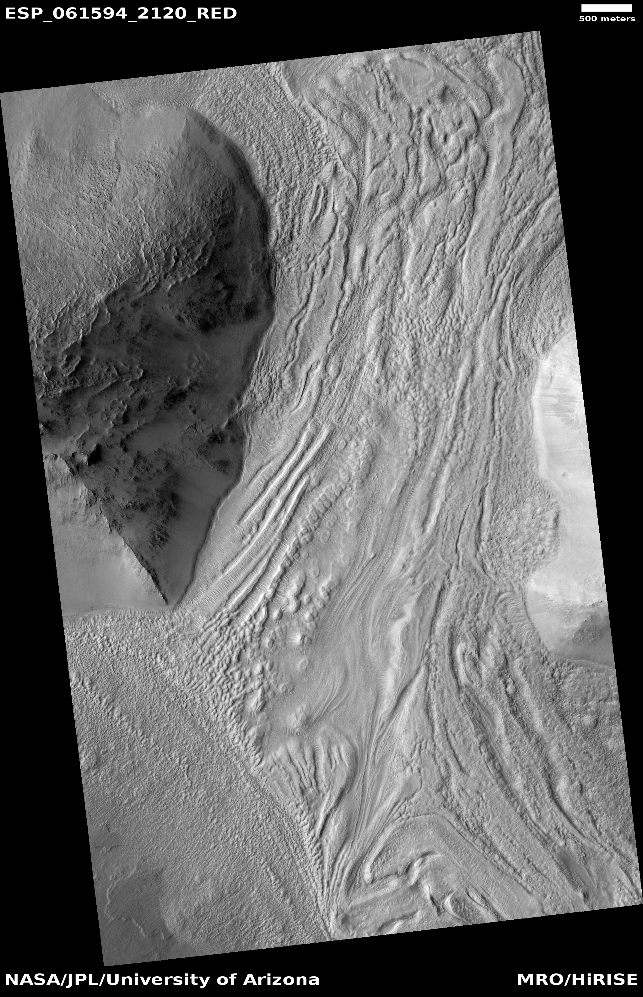
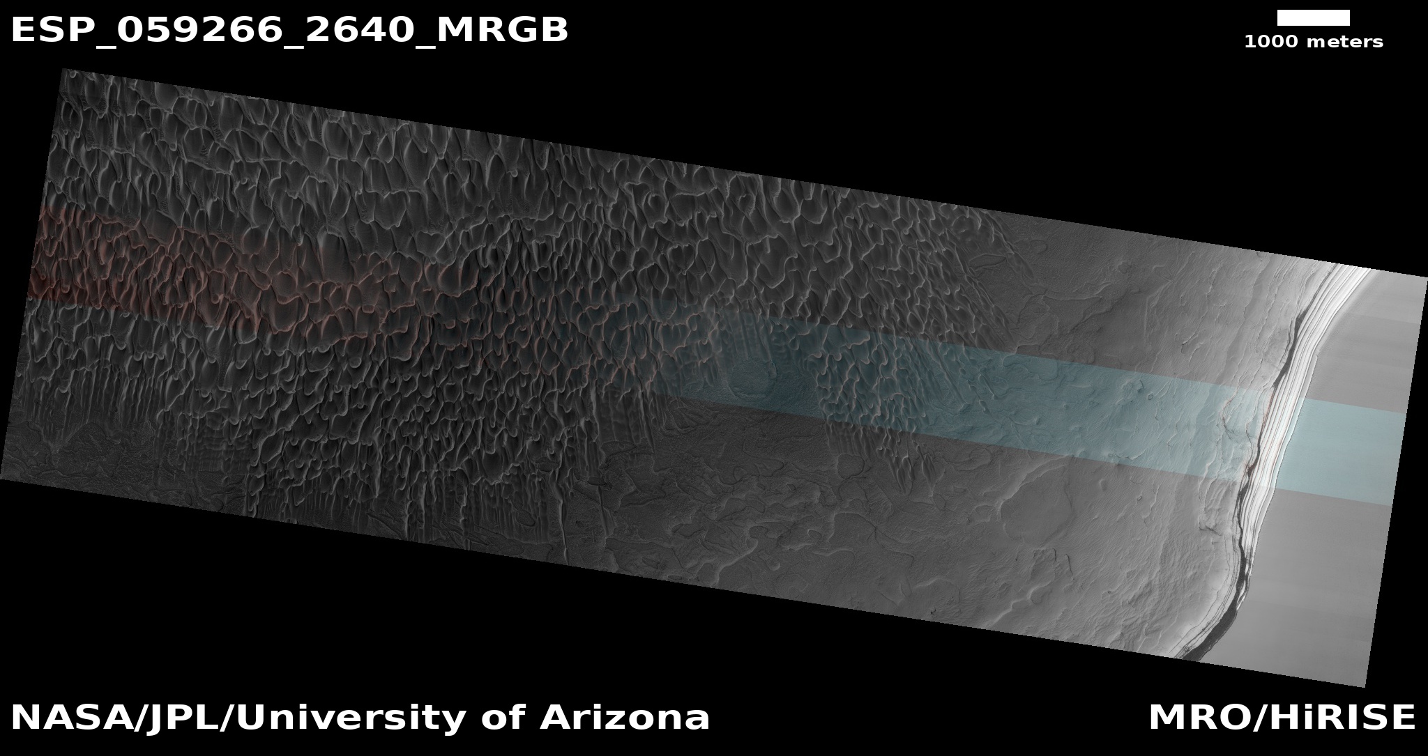
Mid-latitude Martian glacier?

Glacier on Mars?
Click for full image.

Cool image time! I have posted a lot of Mars photographs in the past few months showing possible glaciers in the mid-latitudes of Mars, where scientists think they have identified a lot of such features. Today is another, but unlike many of the previous examples, this particular feature more closely resembles a typical Earth glacier than almost any I have so far posted.

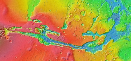
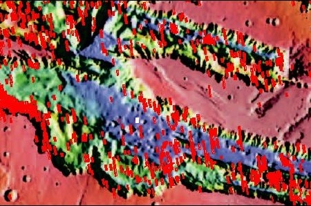
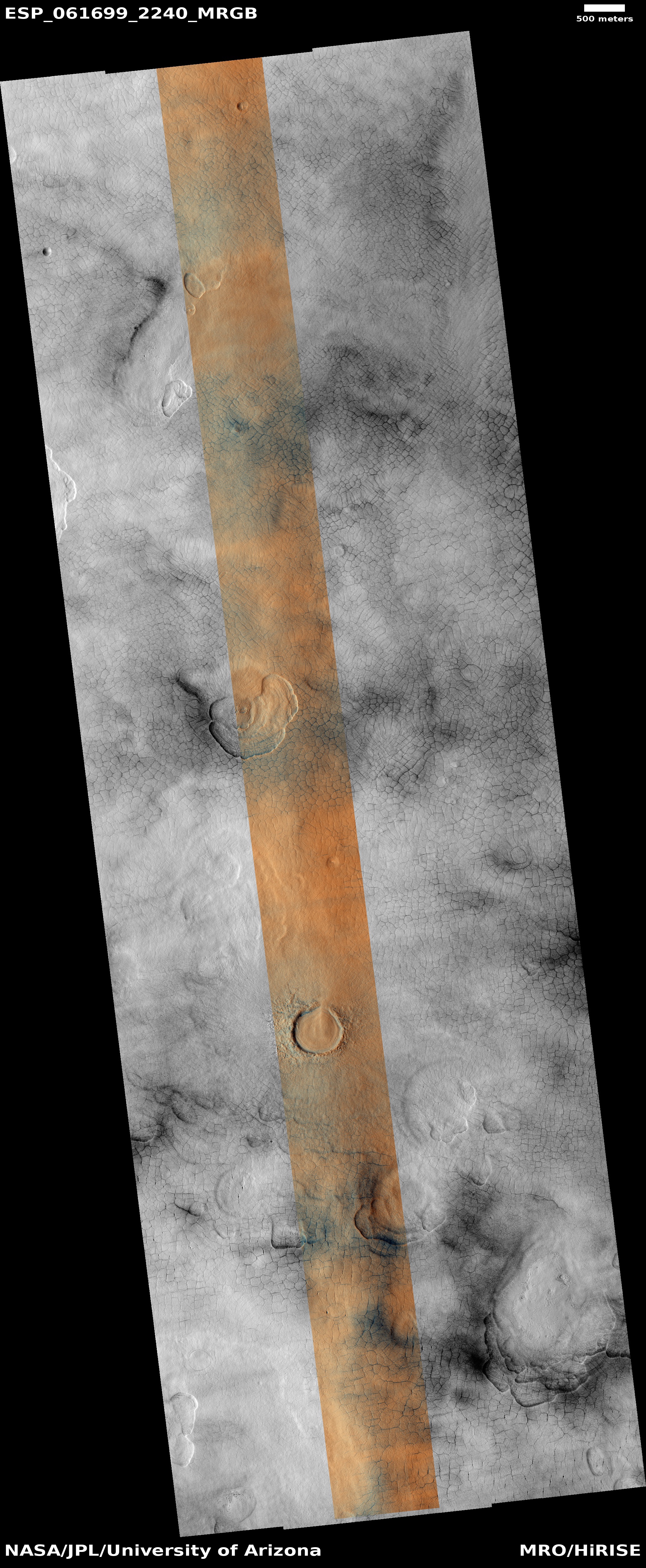
Based on the image’s title, “Lineated Valley Fill in Northern Mid-Latitudes,” given by the science team for the high resolution camera on Mars Reconnaissance Orbiter (MRO), I suspect that it remains unproven that these are features of buried glacial ice. Thus, they use a more vague descriptive term, lineated, to avoid pre-judging what these features are.

Nonetheless, a glacier is sure what this lineated valley fill looks like. See for example the Concordia confluence of two glaciers in the Karakoram Mountains of Pakistan, near the world’s second highest mountain, K2. Though obviously not the same, you can see many similarities between this Martian feature and Concordia.

MRO has taken only three photographs of this particular valley, with one image useless because it was taken during a dust storm. Yet, the other good image, farther downstream in this valley, shows very similar features.

The valley itself is formed from chaos terrain, located in the transition zone between the southern cratered highlands and the flat northern lowlands where a possible intermittent ocean might have once existed. Thus, for buried ice to be here is quite possible.

0 comments

Sinkholes galore!

Sinkholes galore south of Olympus Mons
Click for full image.

Cool image time! The photograph to the left, cropped to post here, was part of the November image dump from the high resolution camera on Mars Reconnaissance Orbiter (MRO). It shows a wind-swept dusty plain trending downhill to the west that is filled with more than a hundred depressions or sinkholes.

Unlike other pit images I have posted previously, this one is not focused on one particular pit or a string of pits. Instead, what makes it interesting is the large number of pits, scattered across the terrain in a random pattern. Their random distribution suggests that they are unrelated to any specific underground feature, such as a lava tube. Instead, some aspect of the underground geology here is causing the ground to sink at random points.

Below is an overview map showing where this dusty pit-strewn plain is located, indicated by the blue cross.
» Read more

1 comment

Recent impact on Mars

Recent impact on Mars
Click for full image.

Cool image time! While finding recent impacts on Mars is not that unusual, the image to the right, found among the November image download from the high resolution camera on Mars Reconnaissance Orbiter (MRO), was dramatic enough that I decided that more people besides planetary scientists should see it. For scale the photograph is exactly 500 meters wide.

The photograph, taken September 26, 2019, also illustrates all the typical aspects of impact craters, and how they change the landscape.

This impact took place sometime between July 17, 2012 and January 4, 2018. We know this because it wasn’t there in a low-resolution image taken by the wide angle survey camera on MRO on the first date but was there when that same camera took another picture on the second date. Below is a side-by-side comparison of that July 17, 2012 image with the high resolution 2019 image above.
» Read more

1 comment

First global geologic map of Titan

Global geologic map of Titan
Click for full image.

Planetary scientists today released the first global geologic map of the Saturn moon Titan. The image on the right is a reduced version of the full image.

In the annotated figure, the map is labeled with several of the named surface features. Also located is the landing site of the European Space Agency’s (ESA) Huygens Probe, part of NASA’s Cassini mission.

The map legend colors represent the broad types of geologic units found on Titan: plains (broad, relatively flat regions), labyrinth (tectonically disrupted regions often containing fluvial channels), hummocky (hilly, with some mountains), dunes (mostly linear dunes, produced by winds in Titan’s atmosphere), craters (formed by impacts) and lakes (regions now or previously filled with liquid methane or ethane).

To put it mildly, there is a lot of uncertainty here. Nonetheless, this is a first attempt, and it shows us that the distribution of these features is not homogeneous. The dunes favor the equatorial regions, the lakes the polar regions. Also, the small number of craters could be a feature of erosion processes from the planet’s active atmosphere, or simply be because Cassini’s radar data did not have the resolution to see smaller craters. I suspect the former.

0 comments

Islands of ice on Mars and Pluto

Ice-filled craters near Martian south pole

In a paper published today in the Journal of Geophysical Research: Planets, scientists describe the identification of 31 ice-filled craters in the high southern latitudes of Mars. The map to the right, from their paper, shows the locations of these craters. The scientists also took a look at Pluto, and found five craters there that had similar features, though these were likely filled with frozen nitrogen, not water ice.

From their abstract:

These new 31 ice deposits represent an inventory of more than 10 trillion cubic meters of solid water, similar to but greater in number and volume than previously studied features near the north pole. Similar features of nitrogen ice may exist in craters on Pluto, suggesting that craters are a favorable location for the accumulation or preservation of ices throughout the Solar System. [emphasis mine]

These results are reinforced by the existence of glacial features found in numerous Martian craters at much lower latitudes, as well as the ice suspected to exist in the permanently shadowed craters on the Moon and Mercury. The processes that put the ice there on these different planets might be fundamentally different, but the results are the same: Ice accumulating within craters.

One aspect of these high latitude craters that remains somewhat unexplained is their asymmetrical distribution around the south pole, favoring the side of the planet south of Mars’ giant volcanoes. Moreover, in looking at the ice deposits within these craters the scientists found that the ice seemed to lie off-center within the craters, favoring a similar direction.

Based on the available data, the scientists theorize that the most likely cause of this asymmetric off-center pattern is wind. From their paper:

Basic physical arguments, mesoscale atmospheric models, and geomorphological observations predict deflection of winds emanating from the south pole by the Coriolis Force. Such deflection results in a general westward trend of winds (i.e., easterlies) in the south polar regions outside the [south pole cap], matching the [ice-filled crater] offsets we observe.

This correlation implies that wind is important in … formation and/or evolution [of craters with ice]. For the case where winds control [their] formation, katabatic winds may travel down the east side of crater walls and preferentially deposit ice on the west side of the crater via orographic precipitation as they flow up the west crater wall. This mechanism thus favors local accumulation of ice within craters.

I find it fascinating that the location of ice within craters on Mars might indirectly provide scientists with information about the planet’s global weather patterns. This unexpected connection highlights the need to dismiss no data or feature in trying to understand planetary formation. Unlikely things might answer our questions.

7 comments

A journey into the depths of Valles Marineris

Valles Marineris

Cool image time! Rather than start with the cool image, let’s begin with the long view. To the right is a wide mosaic of Valles Marineris on Mars, the largest known canyon in the solar system. About 2,500 miles long and 400 miles wide, this canyon is so large that it would cover most of the United States if put on Earth. The Grand Canyon, 500 miles long by 19 miles wide, could easily fit within it and not be noticed. In depth Valles Marineris is equally impressive, with a depth of more than four miles, about four times deeper than the Grand Canyon.

A closer view of the central regions of Valles Marineris

The white cross in the mosaic above is where we are heading. You can see it as the white box in the zoomed in overview to the right. This central part of Valles Marineris is named East Melas Chasma, and the red boxes indicate locations where the high resolution camera of Mars Reconnaissance Orbiter (MRO) has already taken images.

As you can see, we do not yet have many high resolution images of this part of the canyon floor. The white box is the most recent image, and is the subject of today’s post.
» Read more

3 comments

Polygons on Mars

Scallops and polygons on Mars
Click for full image.

Cool image time! The photograph on the right, cropped to post here, was taken on September 25, 2019 by the high resolution camera on Mars Reconnaissance Orbiter (MRO) and made public in its November image release. It shows the weird but very typical scalloped terrain, with its adjacent polygon pattern of fractures, found routinely in the northern lowland plains of Utopia Planitia on Mars. From an earlier captioned image from 2006 of these same features:

The scalloped depressions are typical features; a smooth layered terrain located between 40 and 60 degrees in both hemispheres. Scalloped depressions probably form by removal of ice-rich subsurface material by sublimation (ice transforming directly from a solid to a gaseous state), a process that may still be active today. Isolated scalloped depressions generally have a steep pole-facing scarp and a gentler equator-facing slope. This asymmetry is interpreted as being the result of difference in solar heating. Scalloped depressions may coalesce, leading to the formation of large areas of pitted terrain.

The polygonal pattern of fractures resembles permafrost polygons that form in terrestrial polar and high alpine regions by seasonal-to-annual contraction of the permafrost (permanently frozen ground). On Earth, such polygons indicate the presence of ground ice.

On Earth these polygons are most often seen in mud, usually suggesting a drying process where the ground contracts with the lose of fluid. On Mars the cracks probably also form from contraction, but not by the lose of fluid but the lose of water ice as it sublimates into a gas.

These polygons and scallops illustrate an important feature of Mars’ vast northern plains. On large scales these plains appear flat and featureless. Up close however many many strange features, like the polygons and scallops in this image, come into view.
» Read more

3 comments

Mars’ seasonally vanishing carbon dioxide polar cap

Buzzell dunes, March 19, 2019
Click for full image.

Since the onset of the Martian spring in the northern hemisphere back in March of this year, scientists have been busy using the high resolution camera on Mars Reconnaissance Orbiter (MRO) to monitor the expected sublimation and disappearance of the cap of dry ice that falls as snow to become a winter layer mantling both the more permanent icecap of water 7,000 feet deep as well as the giant dune sand seas that surround that northern icecap.

The image on the right was first posted here on Behind the Black on June 6, 2019 as part of a long article describing that northern polar icecap and its annual evolution. It shows a set of dunes that Candice Hansen of the Planetary Science Institute in Arizona, who requested the image, has dubbed “Buzzell.” When that picture was taken in March, the frozen dry ice layer of translucent carbon dioxide still coated the dunes. The image’s darkness is because the Sun has just begun to rise above the horizon at this very high latitude location (84 degrees). The circular feature is likely a buried ancient crater, with the streaks indicating the prevailing wind direction blowing both sand and frost about.

On August 9, 2019 I provided an update on this monitoring, when new images of this same location were downloaded from MRO in April and June. MRO has now taken a new image of Buzzell, on October 2, 2019. Below the fold are all these images so that you can see the sublimation and disappearance of that dry ice layer over time.
» Read more

1 comment

Rover update: October 28, 2019

Summary: Curiosity finally on the move after several months drilling two adjacent holes in the clay unit. Yutu-2 continues roving west, has it now operates during its eleventh lunar day on the far side of the Moon.

For the updates in 2018 go here. For a full list of updates before February 8, 2018, go here.

Curiosity's present location in Gale Crater
Click for original full image.

Curiosity

For the overall context of Curiosity’s travels, see my March 2016 post, Pinpointing Curiosityโ€™s location in Gale Crater.

I have not done any of my regular rover updates since May 30, 2019 because it was simpler to do individual updates for both Curiosity and Yutu-2, the only working rovers presently on other worlds. (If things had gone well, which they did not, we would have had two other lunar rovers in the past six months, one from Israel and one from India, but both crashed during landing.)

However, since Curiosity is finally on the move after spending several months at one location, where it drilled two holes in the clay unit (the material from one used in a wet cup experiment to look for organic life) it is time to update my readers on where Curiosity is and where it is heading.

The first image above and to the right is an annotated overview of Curiosity’s present position, moving south to a line of buttes which scientists have determined delineates the transition from the clay unit to a new geological layer they have dubbed the Greenheugh Pedimont. The yellow lines indicate the area seen in the panorama below, created from two photographs (here and here) taken by the rover’s navigation camera.
» Read more

0 comments

NASA to send new rover to lunar south pole

NASA today announced that it is building a lunar rover that it will send to the lunar south pole, with a target launch date of December 2022.

About the size of a golf cart, the Volatiles Investigating Polar Exploration Rover, or VIPER, will roam several miles, using its four science instruments โ€” including a 1-meter drill โ€” to sample various soil environments. Planned for delivery to the lunar surface in December 2022, VIPER will collect about 100 days of data that will be used to inform the first global water resource maps of the Moon.

This rover appears to be a traditional NASA project, designed, built, and managed by various NASA agencies that also subcontract the work out to private contractors. As the press release says,

VIPER is a collaboration within and beyond the agency. VIPER is part of the Lunar Discovery and Exploration Program managed by the Science Mission Directorate at NASA Headquarters. Ames is managing the rover project, leading the missionโ€™s science, systems engineering, real-time rover surface operations and software development. The hardware for the rover is being designed by the Johnson Space Center, while the instruments are provided by Ames, Kennedy, and commercial partner, Honeybee Robotics. The spacecraft lander and launch vehicle that will deliver VIPER to the surface of the Moon, will be provided through NASAโ€™s Commercial Lunar Payload Services (CLPS) contract, delivering science and technology payloads to and near the Moon. [emphasis mine]

The highlighted words however indicate where this project differs from the past. The launch vehicle and lander are not being designed and built by NASA. They will be provided by commercial vendors.

0 comments

Ancient glacier flows on Mars

Ancient glacial flow in Euripus Mons
Click for full image.

Cool image time! In the recent download of images from the high resolution camera of Mars Reconnaissance Orbiter (MRO), I found the image on the right, rotated, cropped, and reduced to post here. It shows an example of the many glacial flows coming off of the slopes of Euripus Mons, the sixteenth highest mountain on Mars.

We know these are glaciers because data from SHARAD, the ground-penetrating radar instrument MRO, has found significant clean ice below the surface, protected by a debris layer that insulates it. As planetary scientist Alfred McEwen of the Lunar & Planetary Laboratory in Arizona explained to me in a phone interview yesterday,

These are remnant glaciers. Basically they form like glaciers form. They are not active or if they are they are moving so extremely slowly that effectively they are not active.

If you look close, you can see that this particular glacier was made up of multiple flows, with the heads or moraines of each piled up where each flow ended. In addition, this overall glacier appears to have been a major conduit off the mountain, following a gap between more resistant ridges to the east and west.

The sequence of moraines suggest that when the glacier was active, it experienced alternating periods of growth and retreat, with the growth periods being shorter and shorter with time. As a result each new moraine was pushed less distance down the mountain as the previous one.

Euripus Mons is interesting in that it has a very large and distinct apron of material surrounding it, as shown in the overview image below.
» Read more

5 comments

Curiosity takes selfie next to two of its most important drill holes

Curiosity and its most recent drill holes
Click for full image.

The Curiosity science team today released a beautiful mosaic of the rover, stitched from 57 different images. The photo at the right, cropped and reduced to post here, is the annotated version of that image. It shows the rover’s two most recent drill holes to the left. As the view looks away from Mount Sharp, you can see in the distance Vera Rubin Ridge, the floor of the crater, and its rim on the far horizon.

The two drill holes are significant because of the chemical experiment that Curiosity is subjecting the material from those holes.

The special chemistry experiment occurred on Sept. 24, 2019, after the rover placed the powderized sample from Glen Etive 2 into SAM. The portable lab contains 74 small cups used for testing samples. Most of the cups function as miniature ovens that heat the samples; SAM then “sniffs” the gases that bake off, looking for chemicals that hold clues about the Martian environment billions of years ago, when the planet was friendlier to microbial life.

But nine of SAM’s 74 cups are filled with solvents the rover can use for special “wet chemistry” experiments. These chemicals make it easier for SAM to detect certain carbon-based molecules important to the formation of life, called organic compounds.

Because there’s a limited number of wet-chemistry cups, the science team has been saving them for just the right conditions. In fact, the experiment at Glen Etive is only the second time Curiosity has performed wet chemistry since touching down on Mars in August 2012.

This time however was the first time they had used a wet chemistry cup on material from a drill hole. That they were able to do this at all is a testament to the brilliant innovative skills of the rover’s engineers. They had been holding off doing a wet chemistry analysis from drill hole material until they got to this point, but on the way the rover’s drill feed mechanism failed. It took more than a year of tests and experimentation before they figured out a way to bypass the feed mechanism by using the arm itself to push the drill bit into the ground. That rescue made possible the wet chemistry experiment that they initiated on September 24.

The results, which are eagerly awaited, won’t be available until next year, as it will take time for the scientists to analyze and publish their results.

Curiosity meanwhile has moved on, leaving this location where it had remained for several months to march in the past week southward back towards its long planned route up Mount Sharp.

5 comments
1 119 120 121 122 123 157