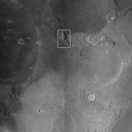
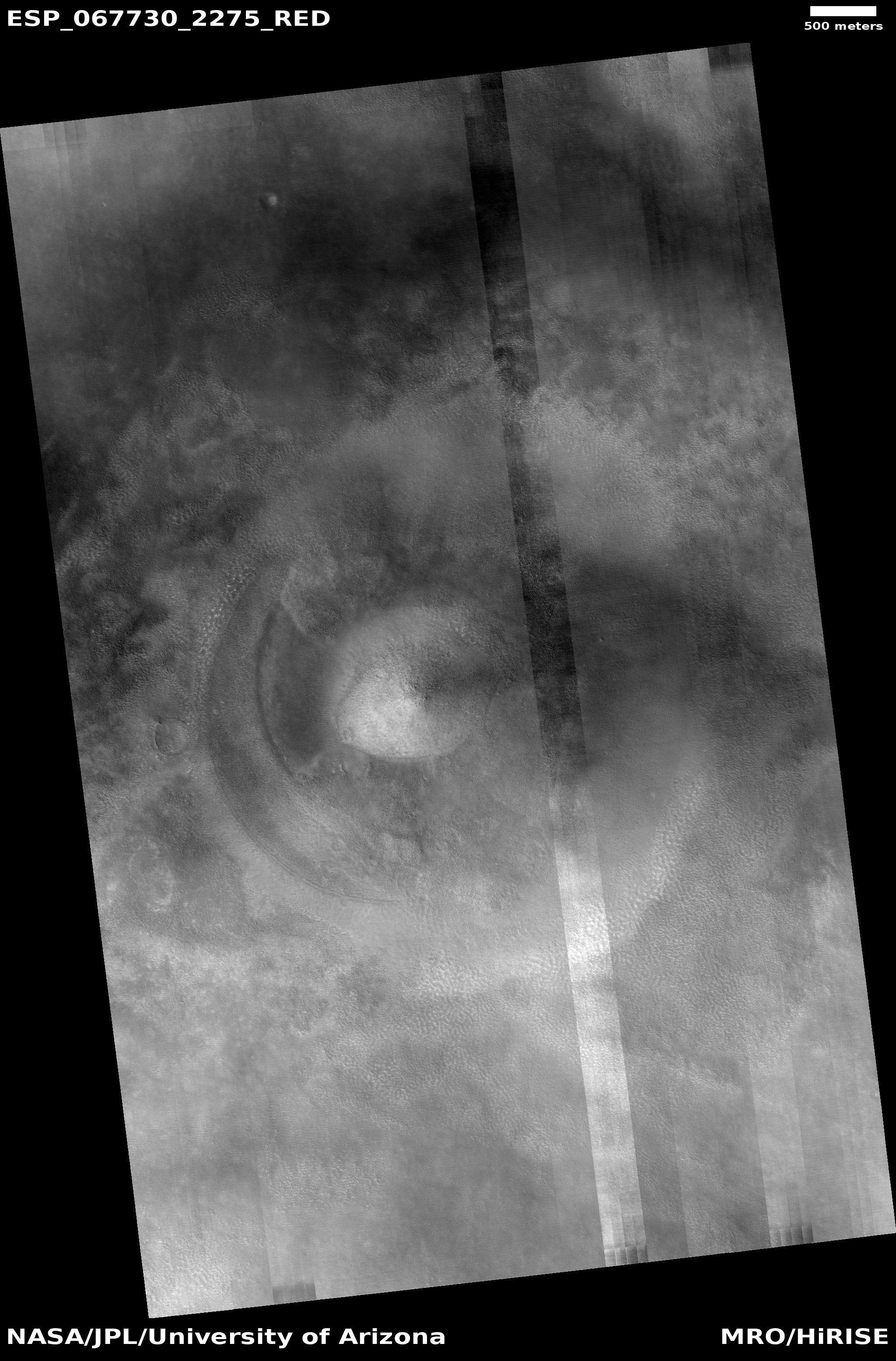
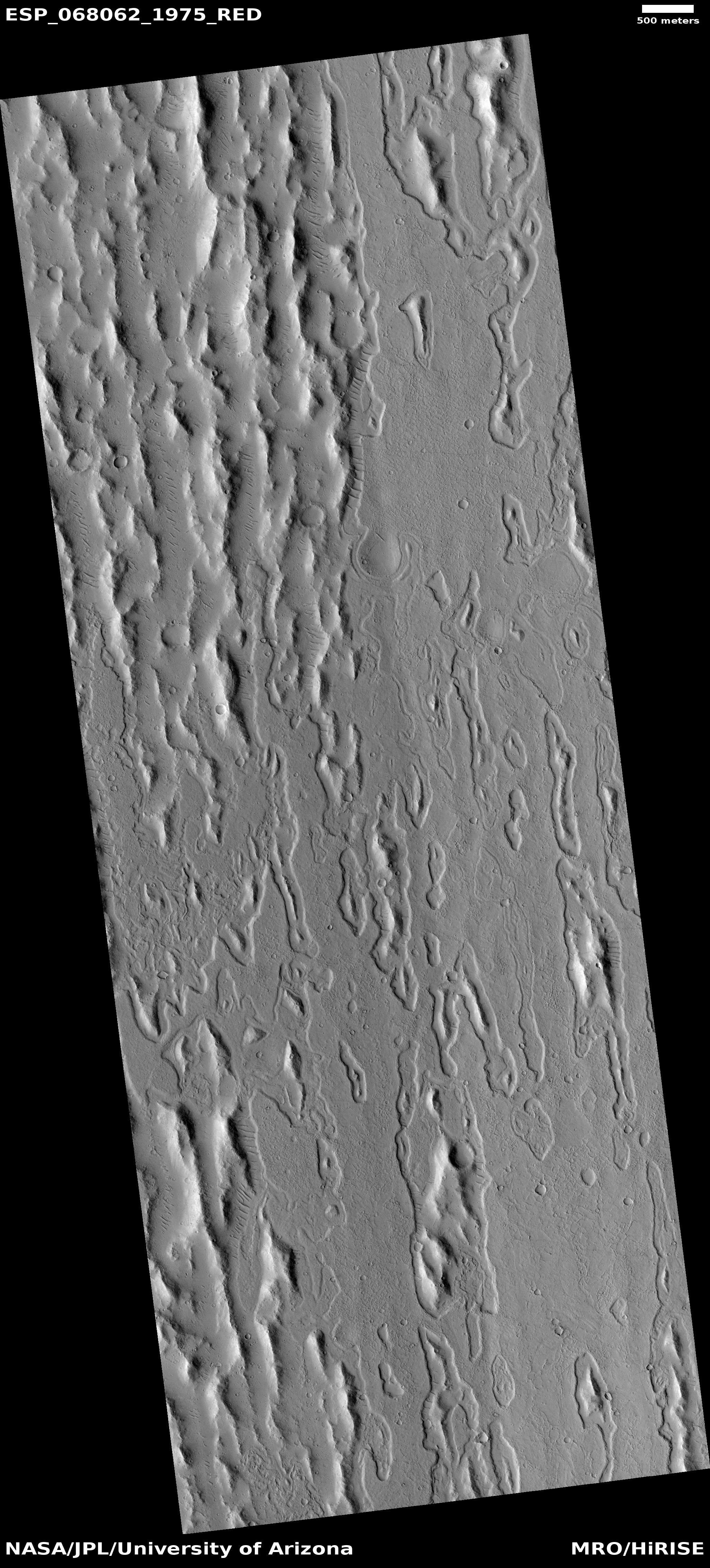
The steep sudden foothill of Olympus Mons

Olympus Mons on Mars

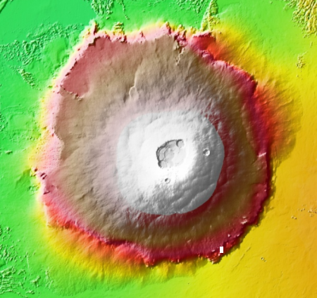
Today’s cool image starts from afar and zooms inward. The elevation map to the right shows Olympus Mons, the largest volcano on Mars and in fact the entire solar system. About 600 miles across, from the edge to its peak this volcano rises about 54,000 feet, with an actual height relative to Mars’ “sea level” of just under 70,000 feet, more than twice as high as Mount Everest on Earth.

The cross-section of this volcano is so large it would cover almost all of France if placed on Earth. As a shield volcano, it was formed by many many volcano flows that laid down many layers of lava, with some in its northwest quadrant thought to be as recent as 2 to 115 million years ago.

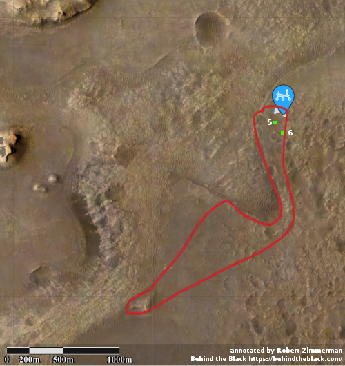
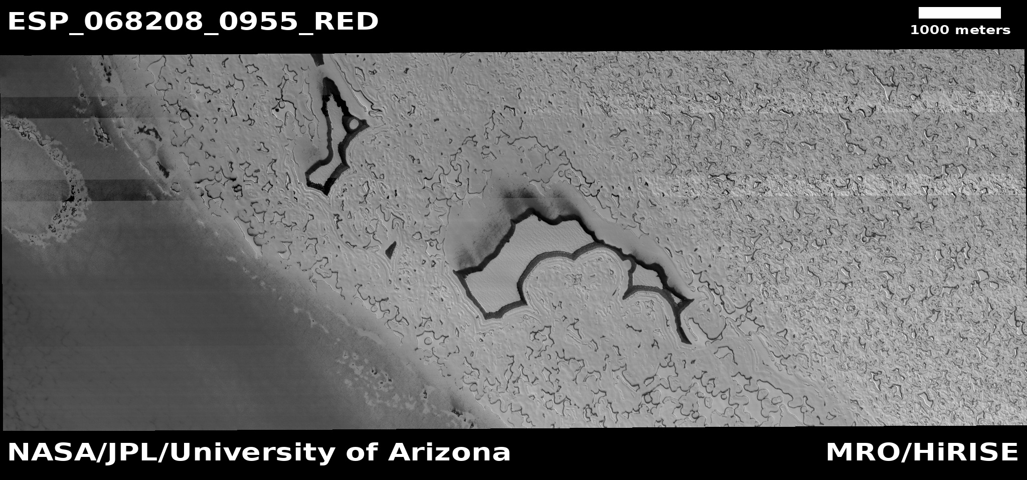
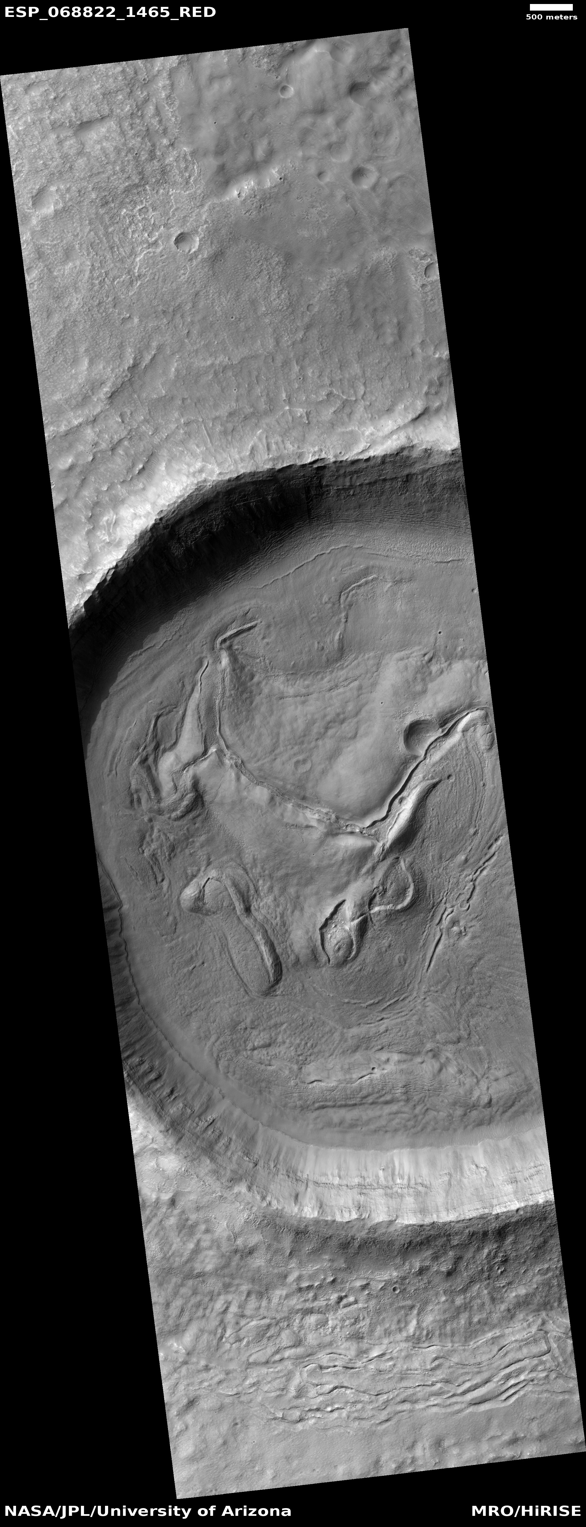
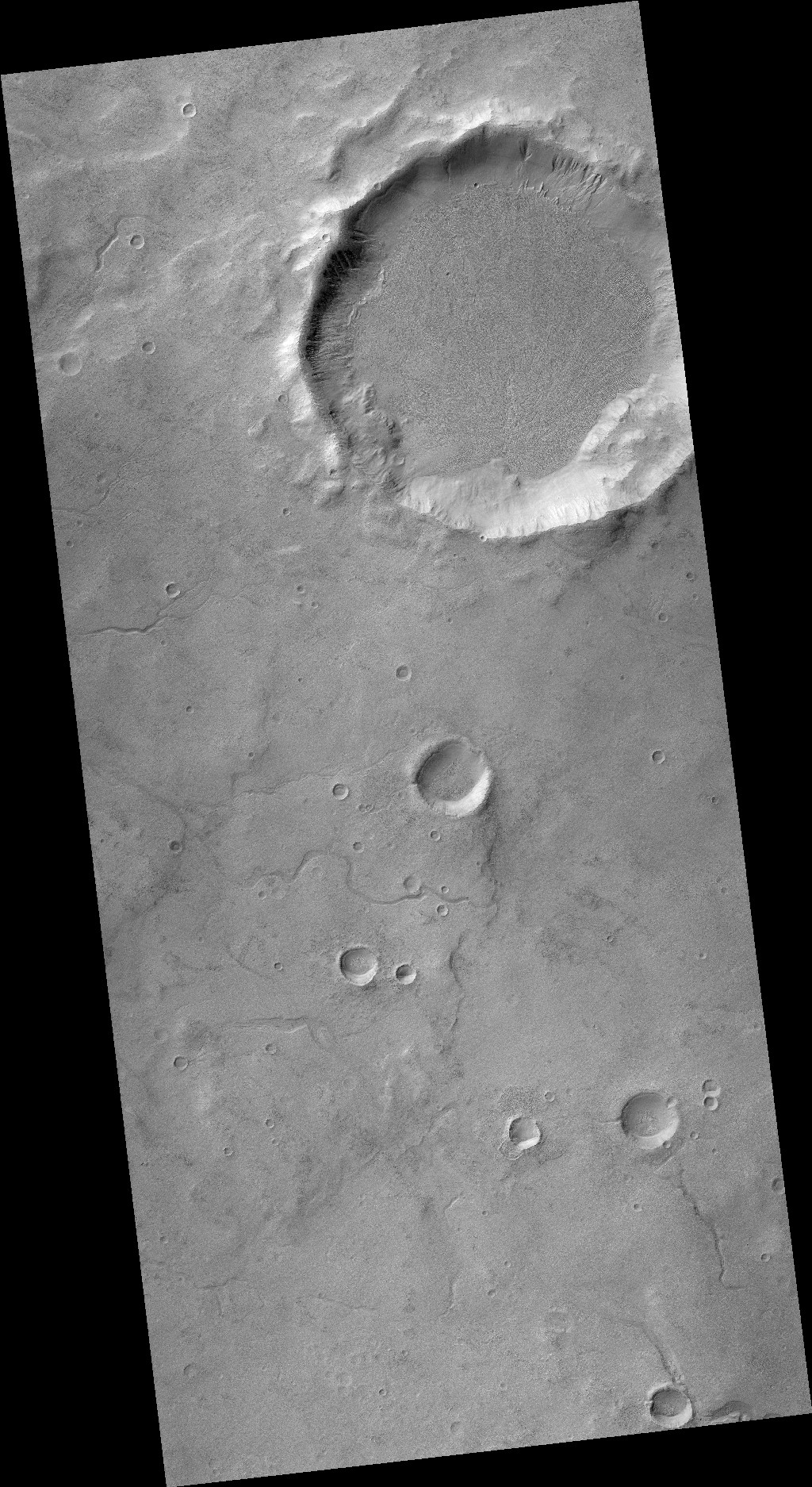
Our cool image today is located at the white rectangle at the southeast edge of this volcano, and illustrates how those many lava flows could create such a large shield volcano with such a large cross section.
» Read more

9 comments

Ingenuity to make sixth flight next week

Future travels for Perseverance and Ingenuity

The Ingenuity engineering team announced today that the Mars helicopter will make its sixth flight next week, flying to a new landing spot while taking images for the Perseverance science team.

Ingenuityโ€™s flight plan begins with the helicopter ascending to 33 feet (10 meters), then heading southwest for about 492 feet (150 meters). When it achieves that distance, the rotorcraft will begin acquiring color imagery of an area of interest as it translates to the south about 50-66 feet (15-20 meters). Stereo imagery of the sand ripples and outcrops of bright rocks at the site will help demonstrate the value of an aerial perspective for future missions. After completing its image collection, Ingenuity will fly about 164 feet (50 meters) northeast where it will touch down at its new base of operations (known as “Field C”).

The flight will attempt a new speed record of 9 mph, and will also land for the first time in a spot that the helicopter has not scouted beforehand. It will instead be using data from high resolution images from Mars Reconnaissance Orbiter (MRO) combined with its own hazard avoidance system.

Ingenuity will essentially place itself over and in an area where Perseverance plans to go, leapfrogging ahead flight by flight, as shown by the map above (annotated by me from the map available here). The green dot numbered 5 shows the helicopter’s present position, while #6 shows its approximate landing spot after its sixth flight. Perseverance, whose present location is indicated by the blue marker, is generally heading south within the area outlined by the red line, as described during the science team’s an April 30th press conference. The goal in exploring this region is to gain a very robust geological baseline of the floor of Jezero Crater, which scientists believe will be the oldest material the rover should see in its travels.

2 comments

Typical but still mysterious gullies in a crater on Mars

Gullies on crater interior wall

Today’s cool image to the right, cropped and reduced to post here, is of a crater in the mid-latitudes of Mars’s cratered southern highlands. The picture was taken on January 4, 2021 by the high resolution camera on Mars Reconnaissance Orbiter (MRO), and is actually the only high resolution image ever taken of this crater.

The gullies in the north interior wall of this crater are the reason why this picture was snapped. These gullies are very typical on the pole-facing slopes of mid-latitude Martian craters, and have puzzled scientists since they were first discovered in the late 1990s in images taken by Mars Global Surveyor. Since then, thousands have been found, almost all of which in the 30 to 60 degree mid-latitude bands where glacial features are also found. Most occur on the more shadowed pole-facing interior slopes of the craters, though at higher latitudes they are also found facing the equator.

Since their discovery scientists have puzzled over their cause, which because of their locations favoring colder temperatures suggest some form of seasonal weather factor. The most preferred hypotheses propose some interaction with water ice or dry ice, or are simply dry flows of rocky granular material. None of these hypotheses have been confirmed. Some evidence suggests they are dry flows, no water involved. Other evidence points to the influence of an underground layer of water ice.

The mystery of these gullies is enhanced by by the wider view from MRO’s context camera below, rotated and cropped to post here.
» Read more

1 comment

Martian mesas made entirely of dry ice!

Dry ice mesas on Mars
Click for full image.

Time for an especially cool image! The photo to the right, taken on February 13, 2021 by the high resolution camera on Mars Reconnaissance Orbiter (MRO) and cropped and reduced to post here, shows some mesas on the south polar ice cap of Mars.

What makes those mesas cool (literally and figuratively) is that they are thought to be made up entirely of dry ice, part of the thin but permanent frozen carbon dioxide cap in the south. As explained to me by Shane Byrne of the Lunar and Planetary Lab University of Arizona, who requested this image from MRO,

[These mesas are] unusually thick compared to other dry ice mesas (a common landform in the residual ice cap). I only have the lower resolution laser altimeter data to go off for heights here (we may get a stereo pair next year), but from that it looks like 13 meters thick.

That’s about forty feet high, from base to top. In length, the largest mesa on the left is about a mile long and about 1,500 feet wide, on average. And it is made entirely of dry ice!

The red cross on the map below shows the location of these mesas on the south pole ice cap.
» Read more

1 comment

The flaking and cracked floor of a Martian crater

The flaking and cracked floor of a Martian crater
Click for full image.

Cool image time! The photo to the right, cropped and reduced to post here, was taken on April 1, 2021 by the high resolution camera of Mars Reconnaissance Orbiter (MRO). It shows the central portion of the floor of an unnamed 5-mile-wide crater in northeast corner of Hellas Basin, the deepest large depression on Mars.

The latitude is 33 degrees south, where many glacier features have been identified, especially inside craters.

In this case, the cracked and flaked surface of this crater floor suggests what geologists call exfoliation, “the breaking off of thin concentric shells, sheets, scales, plates, and so on.” On Earth exfoliation generally refers to an erosion process seen on rock faces, though you can see it on other types of materials.

In this Martian crater we appear to be seeing the exfoliation of different ice layers, sublimating away at different rates as they are exposed to the Sun. The layers probably suggest different periods on Mars when snow was falling here, causing the glaciers to grow. The sublimation we see now suggest periods when this region was warmer and the ice was shrinking. Whether we are in such a period now is not yet determined by scientists.

Either way, the photo suggests at least two such cycles, though if we could drill down into this material we would likely find evidence of many more.

Below the fold is a global map of Mars, showing the location of this crater with a red cross in Hellas. The regions surrounded by white borders are areas where many glacial features have been found.
» Read more

0 comments

Martian glacial run-off?

Mosaic of glacial runoff
For original images click here and here.

Today’s cool image provides us a glimpse at the carved canyons created when the mid-latitude glaciers on Mars were active in the past and slowly flowing downhill into the section of the northern lowland plains dubbed Acidalia Planitia.

The photo to the right is a mosaic of two images taken by the context camera on Mars Reconnaissance Orbiter and rotated, cropped, and reduced to post here. The mosaic shows a region at the very edge of Acidalia Planitia at latitude 43 degrees north.

Below is a close-up of the area in the white box, taken by MRO’s high resolution camera on February 28, 2021, as well as a global map marking the location of this image at the very edge of the glacier country found in the chaos terrain of Deuteronilus Mensae.
» Read more

1 comment

A crater with wings!

A crater with wings!
Click for full image.

Cool image time! The photo to the right, cropped and reduced to post here, was taken on April 5, 2021 by the high resolution camera on Mars Reconnaissance Orbiter (MRO), and shows a particularly unusual crater in the southern mid-latitudes on the eastern edge of Hellas Basin.

This region east of Hellas is where scientists have spotted many features that suggest buried glaciers. The terraced material inside this crater, as well as the splattered material surrounding it on three sides, are examples of such glacial material. You can also see similar glacial features, though less pronounced, inside the crater to the north.

The global map of Mars below marks the general location of this crater by a blue cross.
» Read more

3 comments

The layers of Mars’ north pole icecap

The layers of Mars' north pole icecap
Click for full image.

Cool image time! The photo to the right, rotated, cropped, and reduced to post here, was taken on April 1, 2021 by the high resolution camera on Mars Reconnaissance Orbiter (MRO). It shows the high cliff edge of the Martian north polar ice cap, and was taken as part of the springtime monitoring for the numerous avalanches that fall from the icecap’s steep edge every spring.

This particular cliff is probably about 1,000 feet high. I cannot tell if the image captured any avalanches on the very steep north-facing cliff. What struck me about this image however was the terraced layers so visible on the west-facing scarp. You can clearly count about eleven distinct and thick layers, each forming a wide ledge.

Each layer represents a different climate epoch on Mars when the ice cap was growing, with new snow being deposited.
» Read more

3 comments

A Martian mud volcano

A Martian mud volcano?
Click for full image.

Cool image time! The photo to the right, rotated, cropped, and reduced to post here, was taken on January 6, 2021 by the high resolution camera on Mars Reconnaissance Orbiter (MRO). It shows a distinct conelike knob in an area of the northern lowland plains of Mars dubbed Acidalia Mensa.

According to this paper [pdf], this is possibly a mud volcano.

Bright pitted cones are common in the northern plains of Mars and have been documented to occur in numerous locations including Acidalia Planitia. Various interpretations of these features have been
proposed but growing consensus in recent literature has favored mud volcanism as the most likely formation mechanism. Mud volcanoes are provocative targets for exploration because they bring to the surface sedimentary materials otherwise inaccessible by normal surface exploration and can aid in reconstructing the sedimentary history of the northern plains. Also, by sampling fluids and sediments from deep in the Martian crust, mud volcanoes may be among the best places to search for ancient and extant life.

A previous cool image post, “Baby volcanoes on Mars”, showed another example in the same general area of Mars.

Though this conclusion is not yet confirmed, the multi-layered apron that surrounds the cone certainly suggests repeated eruptions of muddy water over time.

Scientists have taken many images of this area and cone using MRO’s context camera. (See this image as and example.) All show a very rough terrain, with cracks, fissures, and many smaller cones and knobs. This particular knob however dominates the landscape as one of the largest features. The aprons around it are darker, and appear to have been overlain on top of the nearby rough ground.

If such cones are mud volcanoes, they represent a geological process that is pretty much unique to Mars. There are some comparable features on Earth, but they are rare and do not match exactly.

1 comment

Martian volcanic eruption thought to be only 50,000-210,000 years old

Overview map

Using Mars Reconnaissance Orbiter (MRO) images scientists now believe they have located a volcanic eruption on Mars that could have erupted violently as recently as only 50,000 years ago, and is located deep within Mars’ volcano country. The overview map to the right indicates the location of this volcanic with the blue cross. The red dots surrounded by white ovals are distinct quakes that InSight has detected. From their paper’s abstract:

Stratigraphic relationships indicate a relative age younger than the surrounding volcanic plains and the [nearby] Zunil impact crater (~0.1โ€“1 [million years]), with crater counting suggesting that the deposit has an absolute model age of 53 ยฑ 7 to 210 ยฑ 12 [thousand years]. This young age implies that if this deposit is volcanic then the Cerberus Fossae region may not be extinct and that Mars may still be volcanically active. This interpretation is consistent with the identification of seismicity in this region by the [InSight] lander, and has additional implications for astrobiology.

The Cerberus Fossae region is a series of long fissures that scientists think were created when the underground magma pushed up, stretched the surface, and thus caused it to crack. This particular feature suggests that when the ground cracked it sometimes also did so in conjunction with a volcanic eruption.

Below is a zoomed-in context mosaic, taken from figure 1 of the above paper, showing the feature itself and the surrounding terrain.
» Read more

3 comments

Fresh washes on Mars?

Meandering fresh wash on Mars?
Click for full image.

Cool image time! The photo to the right, cropped and reduced to post here, was taken on January 29, 2021 by the high resolution camera on Mars Reconnaissance Orbiter (MRO). It shows what the science team labels as “Fresh Shallow Valleys”. The section I have focused on shows a particularly interesting meander next to a small crater. The full image shows additional similar channels to the north, with one draining into a larger 3.7 mile wide crater.

The location is in the southern cratered highlands, at about 41 degrees south latitude, where much evidence of buried glacial features are found. That certainly is what we appear to see here. In fact, the wider view afforded by MRO’s context camera reveals many more such channels. That wider view also shows a much larger 18-mile-wide crater just to the north that appears filled with buried ice.

That the scientists label these fresh suggests they think they are relatively young, probably dating from when the most recent cycle of glacial growth probably ended. This would make them about 6 million years ago, based on this paper [pdf] and the second figure from that paper below.
» Read more

0 comments

A river of lava on Mars as long as the Columbia

Lava flow in Kasei Valles
Click for full image.

I’ve said it before and I’ll say it again. Mars is strange, Mars is wonderful, but above all, Mars is alien. Today’s cool image illustrates this saying quite nicely.

The photo to the right, cropped and reduced to post here, was taken on February 1, 2021 by the high resolution camera on Mars Reconnaissance Orbiter (MRO) and was simply labeled “Sacra Sulci Lava”. Sacra Sulci is a section of the Kasei Valles canyon that runs from the north rim of Valles Marineris north about 600 miles where it turns east for about 400 miles to drain out into the northern lowlands plains of Mars. Sacra Sulci is the region where that valley narrows and then turns east.

Apparently the flat smoother areas on the east and south on this image that rise about 60 feet above the surrounding terrain and that also seem to flow around mesas and into canyons are believed to be the edge of a massive lava flow that occurred about 150 to 200 million years ago and drained through Kasei Valles, just like water.

What makes this puzzling, however, is that everything I had read previously about Kasei Valles said that it was thought to have been formed from catastrophic floods of water on early Mars, when the planet was warmer and wetter. In fact, I had posted previously about this theory, and included the map below, taken from figure 8 of this paper [pdf], showing part of the process that some scientists believe occurred.
» Read more

0 comments
1 94 95 96 97 98 157