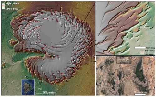
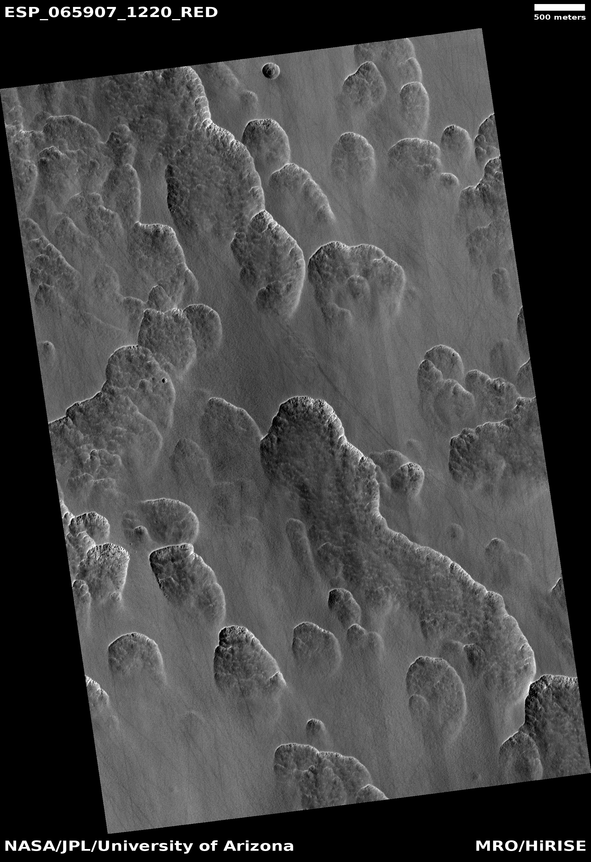
Ice-filled crater in Mars’ glacier country

Crater filled with ice
Click for full image.

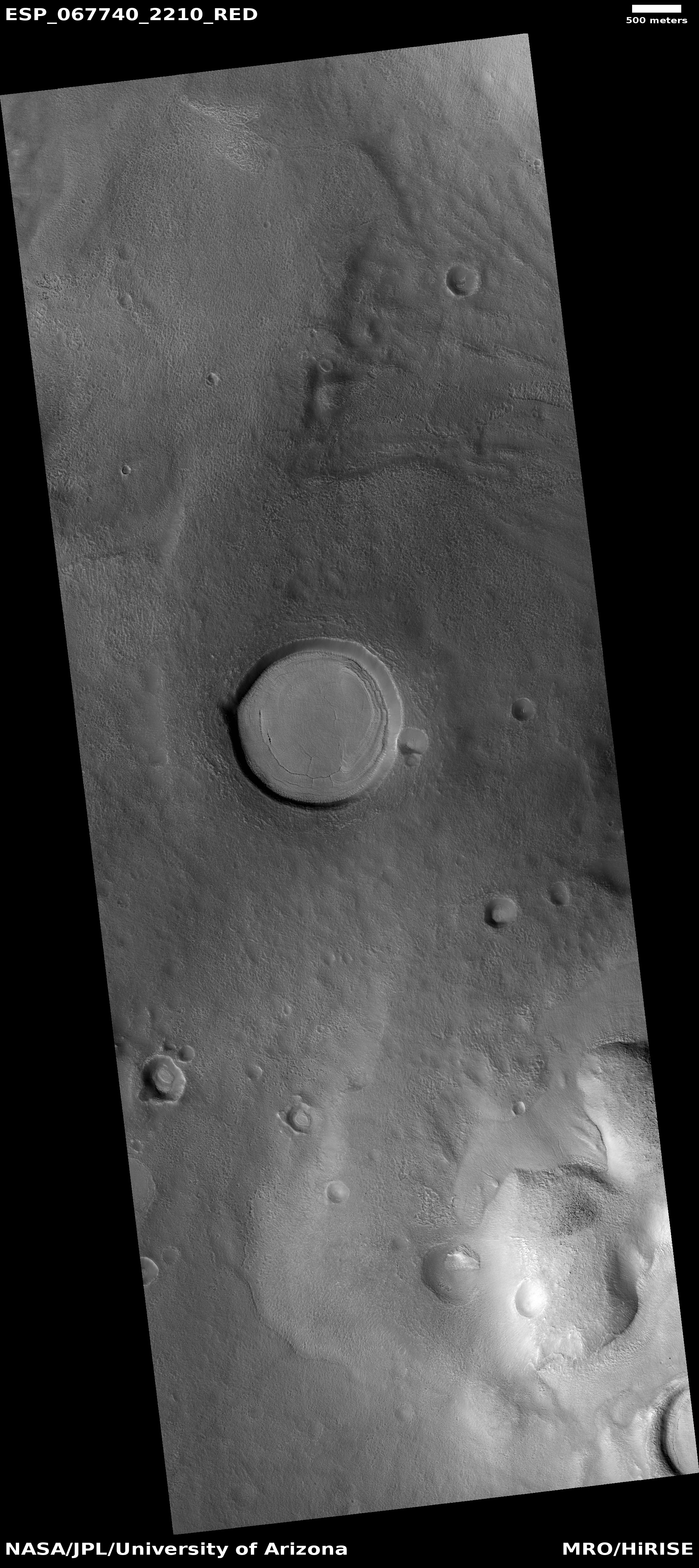
Cool image time! The photo to the right, cropped and reduced to post here and taken on January 7, 2021 by the high resolution camera on Mars Reconnaissance Orbiter (MRO), provides us a perfect example of the kind of glacial feature that scientists find routinely in the 30 to 60 degree mid-latitude bands on Mars. In this case the crater is in the northern reaches of a chaos region dubbed Nilosyrtis Mensae, the easternmost mensae region of what I dub glacier country on Mars.

When first identified scientists named this concentric crater fill, a purposely vague term that is only descriptive because they then did not know what it was made of, though they had their suspicions that it was buried glacial ice. Since then radar data has routinely confirmed that there is ice in such filled craters, making this particular glacial feature one of the most prevalent in those mid-latitude bands.

You can see a quite similar ice-filled crater, also in Nilosyrtis, in an earlier post from October 2020. While that earlier crater was on the southern edge of Nilosyrtis, today’s crater is about 300 miles almost due north, near the region’s northern fringe. In between are lots of similar glacial features, sometimes in craters, sometimes flowing off the slopes of mesas, and sometimes flow features in the open canyons between.

2 comments

Mars’ polar ice canyons are young and the source for mid-latitude ice

Mars' north pole icecap
Mars’ north polar ice cap.

Scientists have now proposed that the giant ice canyons seen at the edges of Mars’ polar ice caps are very young and are also the source of the water that sublimates away when the planet’s rotational tilt (its obliquity) is high, to fall as snow in the mid-latitudes where it forms the glaciers and ice sheets we now find there.

The image to the right, reduced to post here, shows the entire north pole ice cape on the left, with its spiral canyons. The two inserts on the bottom show for scale Hawaii’s Big Island and the Grand Canyon. From the release:

“Erosion formed a huge ice canyon system, and that erosion is a source of the long-known mid-latitude mantles on Mars,” said Rodriguez, lead author of “North polar trough formation due to in‑situ erosion as a source of young ice in mid‑latitudinal mantles on Mars” that appears in Nature Scientific Reports.

The troughs are arranged in a vast spiral pattern covering an area the size of Texas. We find that their growth lateral to katabatic wind (wind that carries high-density colder air from a higher elevation down a slope) directions produced widespread simple intersections, from which the highly complex spiral arrangement emerged, Rodriguez said. “The spiral pattern seen in the troughs is basically an erosional byproduct,” he said. “As the pits grow and intersect over a pre-existing dome-shaped polar cap, the spiral pattern emerges.

“It has long been proposed that sublimation of water ice from the north polar cap during high-obliquity cycles was an essential source of the planet’s mid-latitude icy plains. Our finding identifies the troughs as direct evidence of those sublimation phases,” Rodriguez said.

These spiral trough features formed very recently, in geologic terms: between a few million and 50,000 years ago, Rodriguez said.

This hypothesis, if true, is very important in understanding the long term geological history of Mars. The present theory is that when the obliquity rises to as high of 60 degrees, compared to today’s 25 degrees (similar to Earth’s), the mid-latitudes are colder than the poles, and the ice at the poles then migrates to the mid-latitudes. This paper gives us the place at the poles where the icecap shrinks as that ice sublimates away.

Knowing that these polar canyons are young and the source of the mid-latitude ice scientists can now begin to write the geological history of the polar ice caps themselves. They can also use this information to maybe determine whether the caps are presently in a steady state, as now believed, or growing or shrinking.

The youth of these canyons also suggests that any mid-latitude ice from them is also young, and thus more likely pure water unpoisoned by the toxic perchlorates found in many places on the Martian surface. It will thus be easier to obtain pure drinkable water from them.

0 comments

Layers upon layers of Martian volcanic ash

Layers upon layers of Martian volcanic ash
Click for full image.

Today’s cool image provides I think a hint at the vast amount of time that has passed on Mars, allowing uncounted major events to occur which each lay down a bit of the geological history, a history that is now piled up on the surface so deeply that it will take decades of research to untangle it.

The photo to the right, cropped and reduced to post here, was taken on December 23, 2020 by the high resolution camera on Mars Reconnaissance Orbiter (MRO). It shows the layered nature of the Medusae Fossae Formation, the largest volcanic ash deposit on Mars (about the land area of India) and thought by some to be the source of most of the dust across the entire red planet.
» Read more

0 comments

Scientists: Mars is losing water seasonally through its atmosphere

The uncertainty of science: Two new studies using data Europe’s Trace Gas Orbiter and Mars Express orbiters have found that Mars is losing water seasonally through its atmosphere.

The studies also found that global dust storms accelerate the process.

Anna and colleagues found that water vapour remained confined to below 60 km when Mars was far from the Sun but extended up to 90 km in altitude when Mars was closest to the Sun. Across a full orbit, the distance between the Sun and the Red Planet ranges from 207 million to 249 million km.

Near the Sun, the warmer temperatures and more intensive circulation in the atmosphere prevented water from freezing out at a certain altitude. “Then, the upper atmosphere becomes moistened and saturated with water, explaining why water escape rates speed up during this season – water is carried higher, aiding its escape to space,” adds Anna.

In years when Mars experienced a global dust storm the upper atmosphere became even wetter, accumulating water in excess at altitudes of over 80 km.

But wait, didn’t planetary scientists just announce that Mars hasn’t lost its water through the atmosphere, but instead lost it when it became chemical trapped in the planet’s soil? Yup, they did, but that was a model based on new ground data. This new result is based on atmospheric data.

Or to put it another way, the model was incomplete. While it could be true that a large bulk of Mars’ water is trapped chemically in the ground, that is not proven, only hypothesized. What has been proven, and is now confirmed by these two studies, is that, depending on weather and season, the water of Mars does leak into its upper atmosphere where it can escape into space, never to return.

What remains unknown is how much water escaped into space, and when. Moreover, the ground-based model could still be right, even if it is true that Mars is losing water through its atmosphere. At the moment the data is too incomplete to answer these questions with any certainty.

Meanwhile, this press release once again gives the false impression that the only water left on Mars is at its poles (and in this case, only the south pole). This is not accurate, based on numerous studies finding evidence of buried ice and glaciers everywhere on the planet down to the 30th latitude, in both the north and south hemispheres. Mars might have far less water now than it did billions of years ago, but it still has plenty, and that water is not found only at the poles.

2 comments

Twisted and tilted bedrock in Martian crater

tilted strata in Martin Crater
Click for full image.

Cool image time! The photo to the right, rotated cropped, and reduced to post here, is only a small example of the strangely tilted and twisted strata in the central peak region of 38-mile-wide Martin Crater on Mars. The full image shows more.

The picture was taken on January 12, 2021 by the high resolution camera on Mars Reconnaissance Orbiter (MRO). The section I’ve cropped out shows a series of stratified strata that are are not only significantly tipped from the horizontal, but have also been bent and deformed.

The crater itself is located about 260 miles south of Valles Marineris, as shown on the overview map below.
» Read more

2 comments

A visit to Cydonia on Mars

Strange geology in Cydonia on Mars
Click for full image.

Cool image time! The Cydonia region on Mars, located at around 30-40 degrees north latitude in the northern lowland plains just beyond the transition zone up to the southern cratered highlands, is well known to many on Earth because it was here that the Viking-1 orbiter took a picture of a mesa that, because of the sun angle, made its shadows resemble a face. Thus was born the “Face on Mars” that consumed the shallow-minded among us — and thus the culture, media, and Hollywood — absurdly for decades, until Mars Global Surveyor took the first high resolution image and proved without doubt what was really obvious from the beginning, that it was nothing more than a mesa.

Cydonia however remains a very intriguing region of Mars, mostly because it is home to a lot of strange geology, as shown by the photo to the right, rotated, cropped, and reduced to post here. Taken on January 16, 2021 by the high resolution camera on Mars Reconnaissance Orbiter (MRO), it shows some of that strange and inexplicable geology.

While Cydonia is inside that 30-60 degree latitude band where MRO has imaged numerous glacial-type features, I do not know if many such features have been found there. Except for the pits and depressions in the photo’s lower right — which suggest decay in an ice sheet — little else at first glance in the picture clearly invokes any of the obvious glacial features one comes to expect. There appear to be what might be lobate flows in the image’s center going from the west to the east, but if they are glacial, they are so decayed to as leave much doubt.

The overview image below shows where Cydonia is on Mars, and helps explain partly what is found here.
» Read more

6 comments

Volcanic badlands on Mars

Volcanic badlands on Mars
Click for full image.

Cool image time! The photo to the right, cropped and reduced to post here, was taken on January 29, 2021 by the high resolution camera on Mars Reconnaissance Orbiter (MRO). It shows a particularly ugly region of rough terrain located about 900 miles to the southwest of the giant volcano Arsia Mons, the southernmost of the chain of three giant volcanoes between Olympus Mons and Valles Marineris. The picture sits inside the floor of a very old and degraded 185-mile-wide crater dubbed Koval’sky.

The section I cropped out was picked at random, because the entire full image looked like this. Though only a handful of images have been taken of the floor of Koval’sky Crater by MRO’s high resolution camera, all show similar rough terrain. In June 2017 the MRO science team posted one of those few such photos with the following caption:
» Read more

4 comments

A drainage channel on Mars

A drainage channel on Mars
Click for full image.

Today’s cool image from Mars highlights what is probably the biggest geological conundrum the red planet presents for planetary scientists. The photo to the right, rotated, cropped, and reduced to post here, was taken on February 1, 2021 by the high resolution camera on Mars Reconnaissance Orbiter (MRO). Though I have cropped it, I have cropped out very little, because the entire meandering drainage valley is its most interesting feature, and that takes up almost the entire image.

The photo was simply labeled by the camera team a “terrain sample northwest of Sytinskaya Crater”, so I suspect this was taken not in connection with any specific research but because they must use the camera at a regular intervals to maintain its temperature, and when they have gaps in their schedule they try to pick spots of interest in areas that have not had many high resolution photos taken. In this case however I suspect the location choice was very far from random, as they clearly wanted to capture this drainage system, in its entirety.

I called this merely a drainage channel without indicating what caused the channel, be it liquid water, ice, or wind, because in this case that is a main question. At first glance an Earthman will immediately suspect water, which is what scientists supposed for the last half century. The problem with that conclusion is that the Martian atmosphere is too cold and thin for liquid water to exist on its surface, and though there seems to be plenty of evidence that liquid water once existed there, no scientist has yet come up with a completely accepted climate model that allows for such conditions in anytime in Mars’ past.

The rover Opportunity found that some channels it explored might have been carved by wind, though to our human eyes it seems unlikely that a meandering tributary system such as this could have been carved by wind. The possibility however must not be dismissed out of hand, since Mars is an alien planet and alien things (to Earth) happen there.

The overview map below might provide some context.
» Read more

0 comments

Quakes on Mars as seen by InSight

Martian quake map as seen by InSight

After completing its first full Martian year on the surface of the Red Planet, the scientists for the lander InSight today gave a report [pdf] of their results at this year’s annual 52nd Lunar and Planetary Science Conference, normally held in Texas but being done virtually this year out of terror of the coronavirus.

All told the lander’s seismometer has, as of just a few days ago, detected just over 500 quakes. The map to the right, showing the most distinct quakes and their locations, was adapted from a different presentation [pdf] at the conference. The numbers indicate the sols after landing when these quakes were detected.

This is essentially the region on Mars that I call volcano country. Some of the lava flood plains here are the youngest on Mars. To the east just beyond the edge of the map is the Tharsis Bulge, which holds Olympus Mons and the string of three giant volcanoes to its east. South of Cereberus Fossae but north of the yellow-colored cratered highlands is the vast Medusae Fossae Formation, the largest volcanic ash deposit on Mars.

The quakes suggest they are occurring as large blocks shift along faults, creating fissures and cracks that geologists call grabens. The long fissures of Cereberus Fossae are considered an example of grabens, so this activity suggests that shifting is still going on in the region.

In addition to outlining the location of the detected volcanoes, the presentation today summarized these other discoveries made by InSight about Mars’ interior structure:

  • The crust of Mars has likely two or three layers either 12 or 24 miles thick, with a total thickness no more than 45 miles. This is much thinner than most scientists had expected.
  • The mantle layer below the crust is estimated at about 250 to 375 miles thick, with a temperature between 1,600 to 1,700 degrees Kelvin. While quite hot, this is a cooler mantle than expected.
  • The core of Mars is somewhere between 1,100 to 1,300 miles in diameter, with a outer layer made of liquid. These results are at the high end of pre-mission expectations.

As already admitted, it was noted that the heat sensor experiment will not be able to provide the interior temperature of Mars, as its digging mole was unable to dig into the ground the 9 to 15 feet planned.

9 comments

Scallops of Martian ice

Scallops of Martian ice
Click for full image.

Cool image time! The photo to the right, cropped to post here, was yesterday’s captioned image from the MRO science team. From the caption, written by Shane Byrne of the Lunar and Planetary Lab University of Arizona,

About a third of Mars has water ice just below the dusty surface. Figuring out exactly where is vital for future human explorers. One of the ways scientists do this is to look for landforms that only occur when this buried ice is present. These scallops are one of those diagnostic landforms.

A layer of clean ice lies just below the surface in this image. As the ice ablates away in some spots the surface dust collapses into the hole that’s left. These holes grow into the scallops visible here as more and more ice is lost.

You can see those holes near the top of the scallop’s slopes.
» Read more

0 comments

A cracking Martian glacier?

A cracking Martian glacier?
Click for entire image.

Cool image time! The photo to the right, cropped to post here, was taken on December 4, 2020 by the high resolution camera on Mars Reconnaissance Orbiter (MRO)

I have cropped it to show at full resolution the area that contains what the scientists apparently consider the most interesting feature in this image, which they have labeled as “pits forming lines.” These are the vertical cracks and strings of holes that can be seen in this glacier-like flow. In addition, you can see that the cracking is not just vertical, but also extends out in horizontal directions, though the widest cracks are all vertical.

The next image below, which is a lower resolution crop of the full photo, shows a wider view to provide a better picture of the glacier itself.
» Read more

2 comments

How the blobby craters on Mars help map the planet’s existing accessible water

Distorted blobby crater rim in Utopia Planitia
Click for full image.

Today’s cool image on the right, rotated, cropped, and reduced to post here, is part of a series of cool images that have repeatedly shown the blobby and squishy look of crater impact sites in the Martian northern lowland plain dubbed Utopia Planitia. Taken on January 2, 2021 by the high resolution camera on Mars Reconnaissance Orbiter (MRO), it shows the southeast rim of a very distorted crater that appears filled with glacial material and is also surrounded by an apron of smooth material.

At 42 degrees north latitude, it is somewhat expected to find evidence of glacial-like features in such a crater. Moreover, throughout the 30 to 60 degree mid-latitude band in Utopia Planitia are found numerous such blobby craters (other examples found here, here, and here), all suggesting that the impact occurred on a flat plain with a layer of water ice close to the surface. The heat of the impact melted that ice layer. In such a circumstance, the crater rims were easily deformed because as liquid water (for a short time) it could flow into any number of shapes.

At least that’s my theory. According to Colin Dundas of the U.S. Geological Survey’s Astrogeology Science Center in Arizona,

The exact processes that create the patterns are still debated. The flattened/degraded rims are not necessarily related to this morphology, as such craters can have sharp rims, so they may relate to post-impact modification.

In other words, later erosion after the crater formed could have rounded the rim and maybe even distorted it from a circle.

Regardless, the processes that made this crater rim look as it does were clearly widespread, as shown in the wider view below, provided by the context camera on MRO.
» Read more

2 comments
1 97 98 99 100 101 157