Maven makes first map of Mars’ high altitude winds

High altitude wind patterns on Mars

Scientists using the Martian orbiter Maven have produced the first global map of the high altitude wind circulation of Mars.

The measurements of winds that were recently mapped above Mars were found at an altitude range of about 140-240 kilometers (85-150 miles) above the planetโ€™s surface.

The wind data has been gathered by the Neutral Gas and Ion Mass Spectrometer (NGIMS). NGIMSโ€™ original purpose was to determine the structure and composition of the Martian atmosphere by measuring in it the amounts of ions (electrically charged particles) and gases. However, although it was not originally designed to do so, in April 2016, the MAVEN team began using NGIMS to observe horizontal winds. Pausing normal collection of data, scientists on Earth programmed the instrument to nod back and forth so that it could detect the direction of winds along its track.

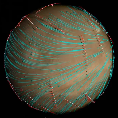
By combining data from many tracks as MAVEN orbits Mars, scientists slowly built up a map of wind behavior. This led to a startling discovery: the wind patterns actually correlated with the Martian topography below.

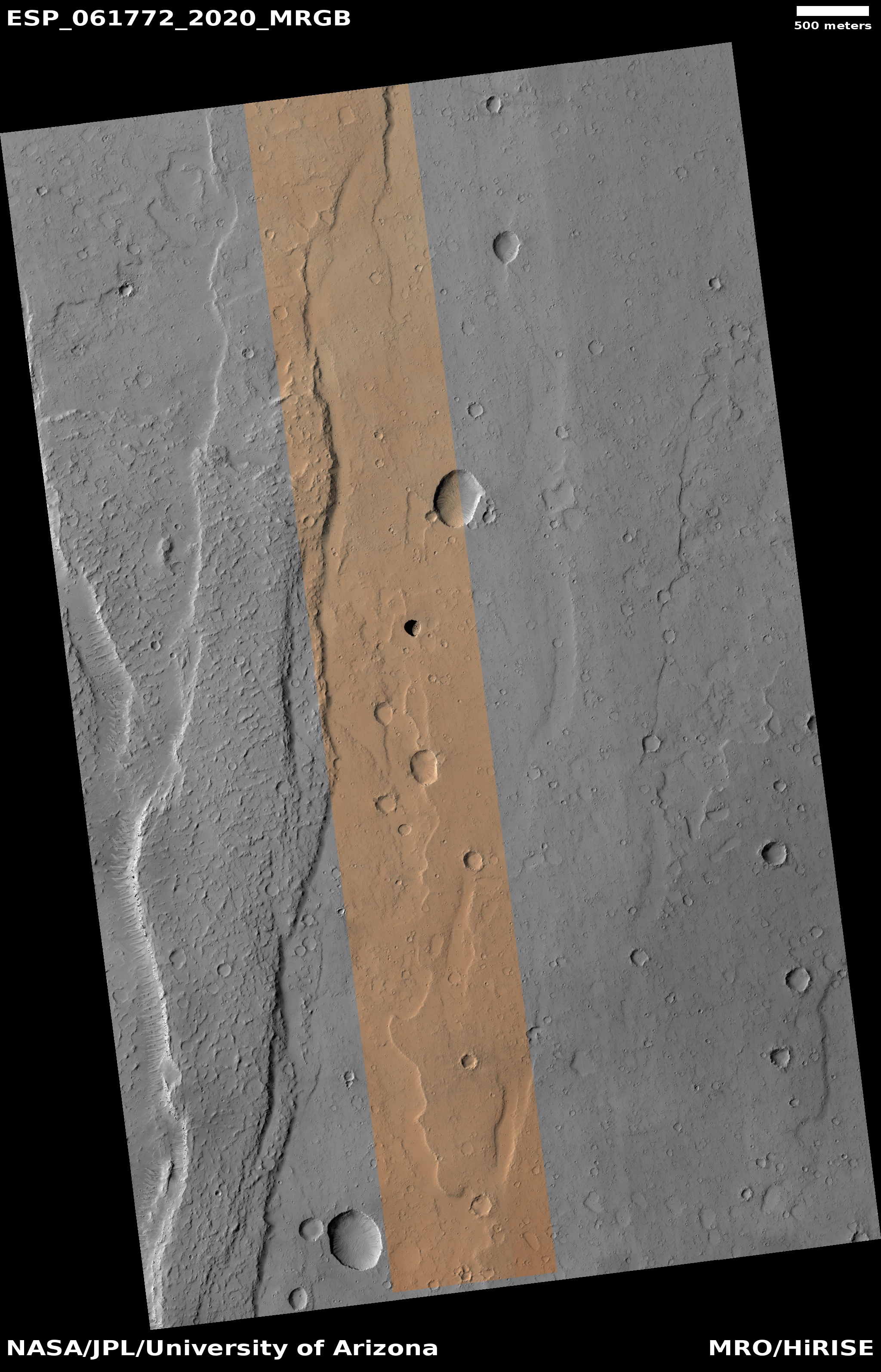
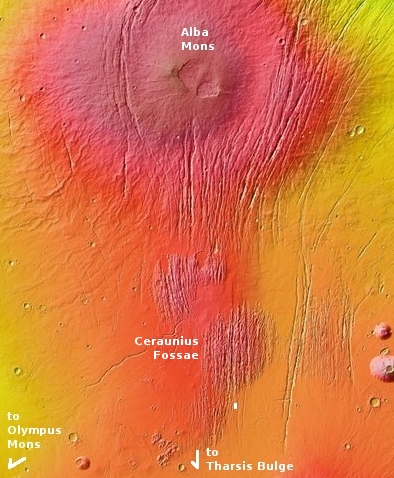
They have found that even at this high altitude the winds shift around the high volcanoes of the Tharsis Bulge.

To my eye, the wind pattern seen in the image, taken from the video at the link, is remarkably similar to the global wind patterns found on Venus, forming a widening V-pattern moving from east to west. Though the two are vastly different, the similarity is quite intriguing.

0 comments

A new map of the water ice on Mars

Annotated water ice map of Mars
Click for full resolution image.

In a new science paper planetary scientists have produced a new global map of the water ice of Mars, based on data from Mars Reconnaissance Orbiter (MRO) and Mars Odyssey.

The image above is a lower resolution version of that map, annotated by me. The black areas are regions covered with a thicker layer of dust, so no good data was obtained. As you go from red to green to blue to purple the ice is thought to be closer to the surface, with the depth as small as an inch in the dark purple areas. The white rectangular represents the region best for human settlement, as it has ice near the surface and is at lower latitudes.

The red box indicates the location in Arcadia Planitia that is SpaceX’s candidate landing zone for Starship. Based on this new water ice map it appears that SpaceX has chosen very well. And the scientists who wrote this paper agree, as noted in the press release: “A large portion of a region called Arcadia Planitia is the most tempting target in the northern hemisphere.”

The map also confirms the existence of the 30 to 60 degree latitude bands where scientists believe a lot of buried glaciers exist. Both bands are both very evident in this new map.

To provide some further context, below is a global map of Mars labeled to show its major geographic features as well as the locations of all previous and upcoming landers/rovers, rearranged to match the water ice map above.
» Read more

10 comments

How the Mars2020 rover differs from Curiosity

A JPL press release today outlines some of the main engineering differences between Curiosity, the rover that has been exploring Gale Crater for the past fifteen years, and Mars2020, the unnamed rover that will be launched in July 2020 to explore Jezero Crater

One of the major the engineering improvements, based on what was learned with Curiosity, are the Mars2020 wheels:

Curiosity has prepared Mars 2020’s team for “off-roading” on the Red Planet. When holes began appearing in the veteran rover’s aluminum wheels, engineers realized that sharp rocks cemented on the Martian surface exert more pressure on the wheels than expected. Careful drive planning, along with a software upgrade, will keep them in shape for the rest of Curiosity’s journey up Mount Sharp.

While Mars 2020’s wheels are made from the same materials, they’re slightly bigger and narrower, with skins that are almost a millimeter thicker. Instead of Curiosity’s chevron-pattern treads, or grousers, Mars 2020 has straighter ones and twice as many per wheel (48 versus 24). Extensive testing in JPL’s Mars Yard has shown these treads better withstand the pressure from sharp rocks but work just as well on sand.

The computer and software has also been upgraded to speed daily operations. In addition, the new rover will have 23 cameras, six more than Curiosity, all of which will be capable of producing color images. And most important, the drill will be larger and will drill cores for obtaining samples that will be stored for possible return by a later mission.

The landing is set for February 18, 2021. If all goes well this rover will be exploring the Martian surface well in to the 2030s.

2 comments

The dark splotches on Mars: Magnets for dust devils

Olympus Maculae, land of dark splotches

One of the numerous geological mysteries that planetary scientists have discovered among the many high resolution images taken by the various Martian orbiters are a series of dark splotches, ranging in diameter from one to fifteen miles, running in an east-west line on the lower western slopes of the giant volcano Olympus Mons.

Scientists have dubbed this string of splotches Olympus Maculae and, because of their superficial resemblance to the islands of Hawaii, have labeled each splotch, or macula, after those islands, as shown in the overview map above, created by geologist Kirby Runyon of the Applied Physics Lab in Maryland as part of a presentation [pdf] given at a science conference in September 2019.

Prior to the 2018 global dust storm on Mars scientists were not quite sure what caused these dark patches. The data suggested the maculae were less dusty than the surrounding terrain, but why this was so was not clear.

The advent of that storm however gave them a chance to get before and after photos. In October 2018 I found several images in monthly download of new images from the high resolution camera of Mars Reconnaissance Orbiter (MRO) and posted them, making a vain attempt to locate what had changed. As I wrote,

I found that MRO has taken images of this location twice before, in 2007 and in 2009. I spent about fifteen minutes trying to find something that had changed, but was unable to locate anything, other than what look like a few wind-blown streaks probably caused by dust devils. I suspect I do not know what to look for.

I then made some guesses about what caused these splotches, all wrong I have since learned.

Since then more images of these splotches have been downloaded from MRO, all once again indicating that changes have been detected. Below is a sequence of images of the splotch dubbed Kaโ€™ula, the first taken in 2008, the second in 2018 just after the global dust storm, and the third in 2019, one year after the storm. Set side-by-side the changes are more obvious.
» Read more

2 comments

A crack in the Martian crust

Crack in the Martian crust
Click for full image.

Cerberus Fossae

The photograph to the right, reduced and cropped to post here, was imaged on October 20, 2019 by the high resolution camera on Mars Reconnaissance Orbiter (MRO). It shows a spectacular thousand-foot-deep canyon in the region of Cerberus Fossae, an area of Mars crossed by numerous deep east-west fissures and depressions.

Hidden in the small white box on the eastern end of that canyon are Martian geological features, small and at first glance not that interesting, that are of great significance and the focus of intense research.

The map to the right shows an overview of the region. The yellow cross shows the location of this particular crack.

In my previous post about Cerberus Fossae, I had incorrectly assumed that these cracks and similar lines of pits or depressions were caused by the sinking of surface material into underground lava tubes. While this is possible in some cases, it is not the main cause of these cracks. Instead, they were formed due to the pressure from below caused by the rise of the surrounding giant volcanoes, Elysium Mons to the north and Olympus Mons to the east. That pressure stretched the crust until it cracked in numerous places. In Cerberus Fossae this produced a series of parallel east-west fissures, some more than seven hundred miles long.

The young age of Cerberus Fossae is dramatically illustrated by the wider mosaic below, showing the entire crack.
» Read more

0 comments

Martian “What the heck?” formations

What the heck caused these?
Click for full image.

Cool image time! In digging through the new images that come down from the high resolution camera on Mars Reconnaissance Orbiter (MRO), my reaction sometimes is “What the heck caused that?”

That was my reaction when I looked at the image to the right, cropped to post here.

The full image, taken on October 6, 2019, shows the floor of one of the many north-south fissures found in the volcanic Tharsis Bulge west of Valles Marineris and east of Olympus Mons. The fissures are caused when the crust is pushed upward by volcanic pressure, causing the surface to crack.

In this case the mystery is that patch of east-west ridges at the bottom of this somewhat wide fissure. While they might be dunes, they do not resemble dunes, as they have a rigid and somewhat sharp appearance. More puzzling is their somewhat abrupt appearance and disappearance. Except for its northern end, the edges of the patch are so sharply defined. If these were dunes you’d think they’d fade away more gradually.

Could the ridges be a more resistant subsurface feature slowly being revealed as surface material erodes away? Sure, but their orientation is completely opposite to the north-south fissures that dominate this region. One would expect deeper features to reflect that same general orientation. These ridges do not.

This image was dubbed a “Terrain Sample,” which means it was taken not because of any specific research goal, but because the scientists who run MRO’s high resolution camera had a gap in their schedule and needed to take a picture to maintain the camera’s proper temperature. In such cases they often take somewhat random images, not knowing what they will find. In this case they struck geological gold, a mystery that some postdoc student could spend a lot of time analyzing.

3 comments

Further explorations at candidate Starship Mars landing site

Beginning of Possible Glacial Unit near candidate Starship landing sites
Click for full image.

Close-up on exposed lower layer

Cool image time! Even though it appears that SpaceX has completed its first round of images of its candidate landing sites surrounding the Erebus Montes mountains in the Arcadia Planitia plains in the Martian northern lowlands, this does not mean that other planetary scientists are not asking for more images of this region, for their own scientific research.

The photograph on the right, cropped and reduced to post here, was released in the early November image download from the high resolution camera of Mars Reconnaissance Orbiter (MRO). Uncaptioned but dubbed “Beginning of Possible Glacial Unit,” it shows what appears at first glance to be a relatively featureless area south of Erebus Montes, out in the flat plains.

A closer look suggests otherwise. For one, the full image shows darker and lighter areas. The close-up to the right, its location indicated by the white box in the wider image above, also shows several intriguing depressions that appear to be revealing a knobby lower layer. In fact, in the full image it appears that the darker areas are areas where material has covered that knobby lower layer. Where it is bright the ground resembles the floors of these depressions, knobby and complex.

I do not know why they label this the “beginning” of a glacial unit. What I do know is that the research of this region has consistently found evidence of a lot of buried ice. To quote Donna Viola of the University of Arizona noted, โ€œI think you could dig anywhere to get your water ice.โ€ The knobby features to me suggest a surface that is showing signs of sublimation, where the exposed ice is slowly eroding. Think of what happens to a block of ice when you spray warm water on it. As it melts it leaves behind just these kinds of strange formations.

Overview of all MRO images at Starship candidate landing site

The red box in the map on the right shows the location of this photograph relative to the other images taken for SpaceX. The white boxes are the company’s images taken for Starship. The black boxes are the images it obtained in 2017 when it was thinking of sending a Dragon capsule to Mars.

This map does not show all images taken by MRO’s high resolution camera in this area, but the coverage is very scattered, with many gaps. Over time I suspect these gaps will be filled more quickly than other northern plain regions, because the scientists know that SpaceX has an interest in this area. That interest means there is an increased chance that a mission will fly here in the relatively near future, which in turn is going to generate more scientific interest as well.

0 comments

More Martian pits, filled and unfilled!

Pit in Ceraunius Fossae
Click for full image.

Overview of Ceraunius Fossae

Time for what has almost become a monthly pit report from Mars Reconnaissance Orbiter (MRO). The November image download from the spacecraft’s high resolution camera included two pit-related photographs, both very different. To the right is the first, cropped to focus on the pit and the immediate surrounding terrain. Below that is a wider overview map to provide the context.

This pit’s location is indicated by the white box at the southern end of a region dubbed Ceraunius Fossae, made of hundreds and hundreds of parallel north-south fissures extending more than seven hundred miles south of the giant volcano Alba Mons and caused when the ground was stretched from below, causing it to crack.

This surrounding terrain helps to explain the pit’s origin. First it is located in a north-south depression with a number of other less pronounced depressions. While these do not line up precisely, they still suggest that they are sinkholes where the surface material is draining downward into voids below. Normally the assumption would be the existence of a lava tube, but here the downward grade is very small. Instead, what is likely happening is that the ground is being stretched, causing cracks to form into which surface material slips downward.

The Ceraunius Fossae fractures are extensional features produced when the crust is stretched apart…. Mechanical studies indicate that a regional pattern of radiating graben and rifts is consistent with stresses caused by loading of the lithosphere by the enormous weight of the Tharsis bulge….Several generations of grabens with slightly different orientations are present in Ceraunius Fossae, indicating that stress fields have changed somewhat over time.

In addition to producing normal faults and graben, extensional stresses can produce dilatant fractures or tension cracks that can open up subsurface voids. When surface material slides into the void, a pit crater may form. Pit craters are distinguishable from impact craters in lacking raised rims and surrounding ejecta blankets. On Mars, individual pit craters can coalesce to form crater chains (catenae) or troughs with scalloped edges.

That’s what we see here. The pit is suggestive of a void below, but it is likely not going to be a long coherent underground passage but a serious of random gaps, aligned roughly along the larger crack and producing the various depressions on the surface.

Today’s second pit is of an entire different nature.
» Read more

1 comment

Mars Express confirms ancient glaciers in northern Martian mid-latitudes

Perspective view of Deuteronilus Mensae
Click for full image.

The European Space Agency’s orbiter Mars Express has confirmed the presence of large fractured ice sheets suggestive of buried and ancient glaciers. These ice sheets are within one region on Mars located in the mid-latitudes where many such glacial features have been found. They are also in the transition zone between the northern lowlands and the southern highlands.

This landscape shows clear and widespread signs of significant, lasting erosion. As is common with fretted terrain, it contains a mix of cliffs, canyons, scarps, steep-sided and flat-topped mounds (mesa), furrows, fractured ridges and more, a selection of which can be seen dotted across the frame.

These features were created as flowing material dissected the area, cutting through the existing landscape and carving out a web of winding channels. In the case of Deuteronilus Mensae, flowing ice is the most likely culprit. Scientists believe that this terrain has experienced extensive past glacial activity across numerous martian epochs.

It is thought that glaciers slowly but surely ate away at the plains and plateaus that once covered this region, leaving only a scattering of steep, flat, isolated mounds of rock in their wake.

Smooth deposits cover the floor itself, some marked with flow patterns from material slowly moving downhill โ€“ a mix of ice and accumulated debris that came together to form and feed viscous, moving flows of mass somewhat akin to a landslide or mudflow here on Earth.

Studies of this region by NASAโ€™s Mars Reconnaissance Orbiter [MRO] have shown that most of the features seen here do indeed contain high levels of water ice. Estimates place the ice content of some glacial features in the region at up to 90%. This suggests that, rather than hosting individual or occasional icy pockets and glaciers, Deuteronilus Mensae may actually represent the remnants of an old regional ice sheet. This ice sheet may once have covered the entire area, lying atop the plateaus and plains. As the martian climate changed this ice began to shift around and disappear, slowly revealing the rock beneath.

Overall, the data coming from both Mars Express and MRO increasingly suggests that there is a lot of buried glacial ice in the mid-latitudes. Mars might be a desert, but it is increasingly beginning to look like much of the planet is a desert like Antarctica, not the Sahara.

4 comments

Mid-latitude Martian glacier?

Glacier on Mars?
Click for full image.

Cool image time! I have posted a lot of Mars photographs in the past few months showing possible glaciers in the mid-latitudes of Mars, where scientists think they have identified a lot of such features. Today is another, but unlike many of the previous examples, this particular feature more closely resembles a typical Earth glacier than almost any I have so far posted.

Based on the image’s title, “Lineated Valley Fill in Northern Mid-Latitudes,” given by the science team for the high resolution camera on Mars Reconnaissance Orbiter (MRO), I suspect that it remains unproven that these are features of buried glacial ice. Thus, they use a more vague descriptive term, lineated, to avoid pre-judging what these features are.

Nonetheless, a glacier is sure what this lineated valley fill looks like. See for example the Concordia confluence of two glaciers in the Karakoram Mountains of Pakistan, near the world’s second highest mountain, K2. Though obviously not the same, you can see many similarities between this Martian feature and Concordia.

MRO has taken only three photographs of this particular valley, with one image useless because it was taken during a dust storm. Yet, the other good image, farther downstream in this valley, shows very similar features.

The valley itself is formed from chaos terrain, located in the transition zone between the southern cratered highlands and the flat northern lowlands where a possible intermittent ocean might have once existed. Thus, for buried ice to be here is quite possible.

0 comments

Unearthly pit in Martian northern icecap

Giant pit in Martian North polar icecap
Click for full image.

Cool image time! It is spring in the Martian north, and thus the Sun has risen and remains in the sky for most if not all of each day, circling the horizon. As such, it illuminates polar icecap features that are strange and weird and hard to decipher based on our expectations here on Earth.

The photograph to the right, cropped and reduced to post here, is a good example. It was taken on September 20, 2019 by the high resolution camera on Mars Reconnaissance Orbiter (MRO), and shows a pit in the outer regions of the polar icecap, an area where that water icecap remains relatively stable, but that is also at a low enough latitude that summer sunlight can cause some erosion and sublimation of the ice.

The bottom of the pit is the center of the bullseye, with the layered features in the surrounding walls showing the many layers inside the icecap, built up over centuries, then slowly revealed as the ice in this pit slowly sublimated away.

You can get a better sense of what you are looking at by the overview map below.
» Read more

0 comments

Sinkholes galore!

Sinkholes galore south of Olympus Mons
Click for full image.

Cool image time! The photograph to the left, cropped to post here, was part of the November image dump from the high resolution camera on Mars Reconnaissance Orbiter (MRO). It shows a wind-swept dusty plain trending downhill to the west that is filled with more than a hundred depressions or sinkholes.

Unlike other pit images I have posted previously, this one is not focused on one particular pit or a string of pits. Instead, what makes it interesting is the large number of pits, scattered across the terrain in a random pattern. Their random distribution suggests that they are unrelated to any specific underground feature, such as a lava tube. Instead, some aspect of the underground geology here is causing the ground to sink at random points.

Below is an overview map showing where this dusty pit-strewn plain is located, indicated by the blue cross.
» Read more

1 comment
1 130 131 132 133 134 212