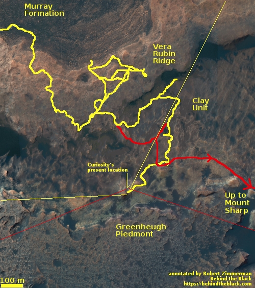
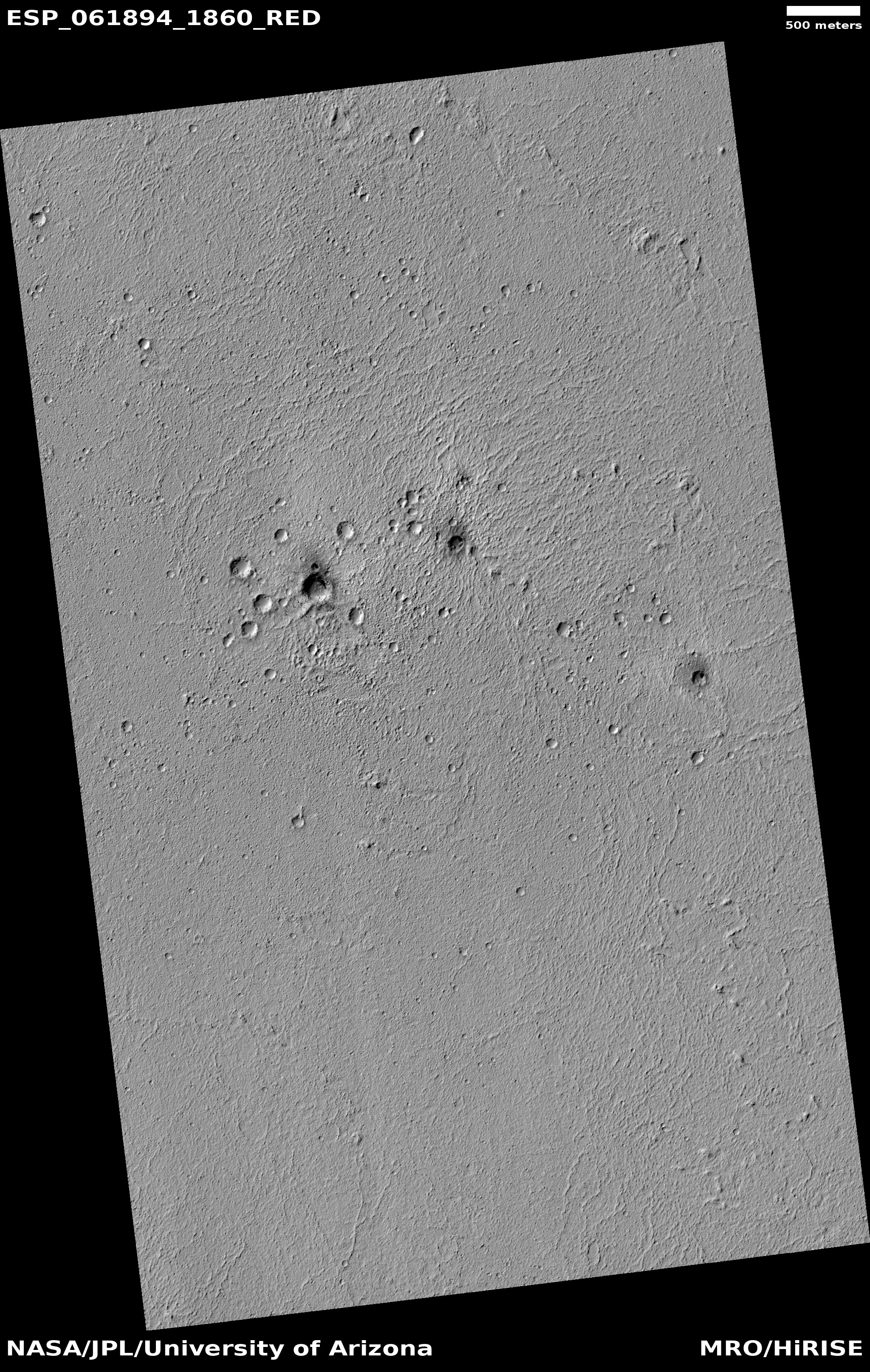
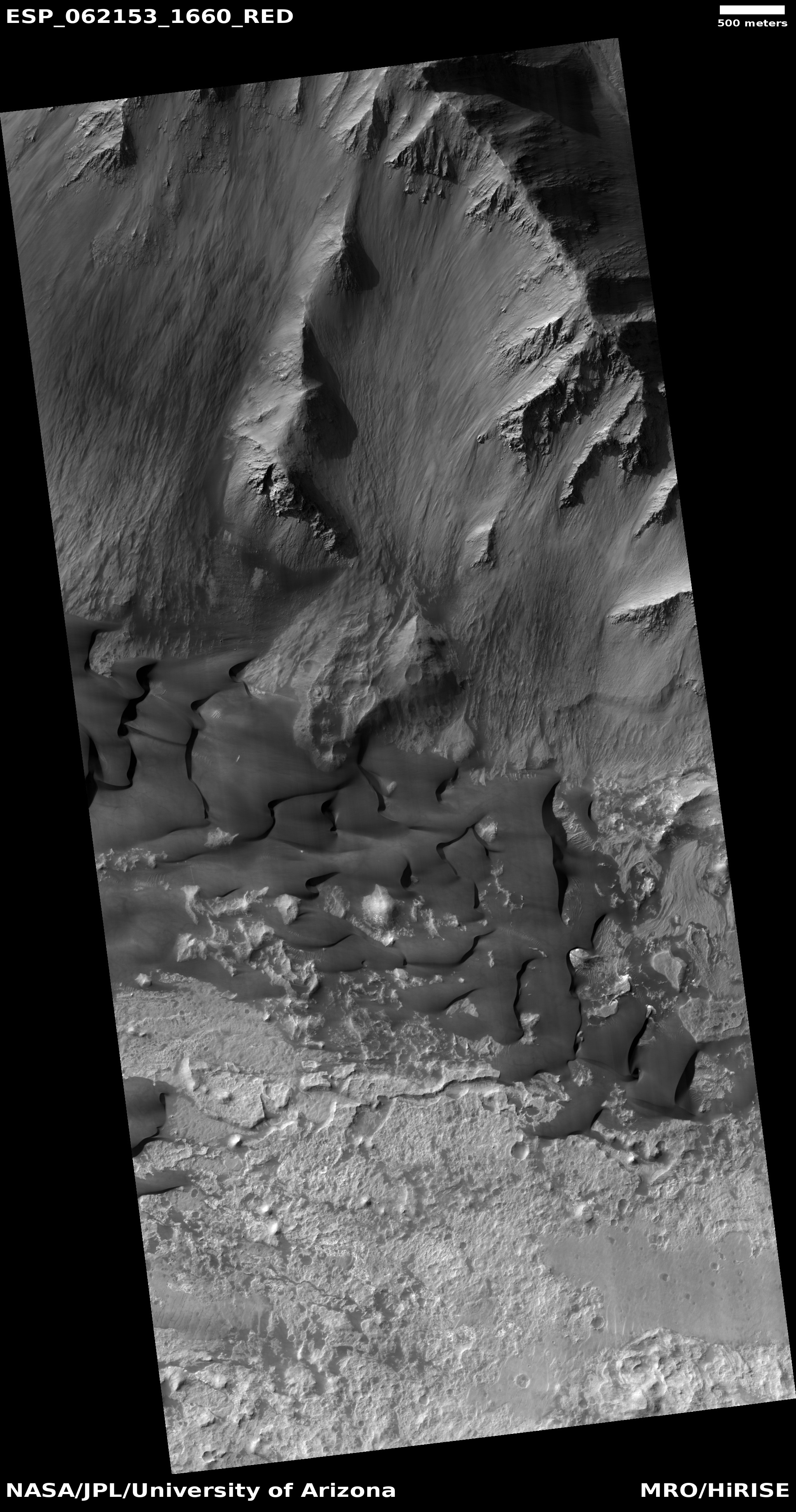
Gully on Mars

Gully in crater on Mars
Click for full image.

Cool image time! If we were told that the photo on the right was taken by an airplane over some southwest desert gully, no one should be surprised if we were to accept that description entirely. The gully sure looks like a lot of drainages one can routinely see when flying over the American southwest, dry, treeless, but showing the typical dendritic pattern seen for most desert water drainages.

Of course my readers all know that this is not in the American southwest, but on Mars, in a crater located in the transition zone between the southern highlands and the northern lowland plains. The image, cropped to post here, was taken by the high resolution camera on Mars Reconnaissance Orbiter on October 12, 2019.

It appears that this particular gully has been subject to repeated monitoring, since November 2015. A rough and very quick comparison of the earlier image with today’s image does not show any obvious change. This does not mean there hasn’t been any evolution, as my look was cursory, and I could easily be missing changes. Seasonal variations might also be occurring that I could be missing.

The reasons for the monitoring are of course obvious. This gully strongly suggests the flow of liquid downhill. Is that occurring today, or are we seeing the evidence of a past flow from long ago? Only some long term monitoring can tell.

There is also the possibility that we are looking at a buried glacier. The crater is located at 42 degrees north latitude, well within that mid-latitude band where scientists have located many buried Martian glaciers. If so, then the monitoring is to see if that glacier is active in any way.

1 comment

Curiosity climbs a hill

Overview map of Curiosity's journey through sol 2643

[For the overall context of Curiosity’s travels, see my March 2016 post, Pinpointing Curiosity’s location in Gale Crater.

For the updates in 2018 go here. For a full list of updates before February 8, 2018, go here.]

Since my last Curiosity update on November 6, 2019, the science team has sent the rover climbing up what they call Western Butte, the butte directly to the west of Central Butte and part of the slope/escarpment that separates the clay unit from the Greenheugh Piedmont and the sulfate unit above that.

The overview map to the right gives a sense of the journey. The thick yellow line indicates its route since it climbed up from the Murray Formation onto Vera Rubin Ridge in 2017. The thick red line indicates their planned route, which they have only vaguely been following since their arrival in the clay unit.

Below the fold are two panoramas that I created from a sequence of images taken by Curiosity’s left navigation camera from the high point on Western Butte, the first looking north across the crater floor to the Gale Crater rim approximately 30 miles away and indicated by the thin yellow lines on the overview map. The second looks south, up hill towards Mount Sharp, and is indicate by the thin red lines.
» Read more

0 comments

Pedestal craters in the Martian northern lowlands?

Pedestal craters on Mars?
Click for full image.

Cool image time! The photo on the right, cropped and reduced to post here, shows a cluster of really strange mesas, craters, and pits, located in Utopia Planitia, the largest and deepest plain of Mars’ northern lowlands where an intermittent ocean might have once existed.

The image was taken on October 26, 2019 by the high resolution camera on Mars Reconnaissance Orbiter (MRO) as part of its regular image-taking program. In this case it was dubbed a “terrain sample” image, meaning that it was not specifically requested by any researcher, but was taken because they need to use the camera regularly to maintain its temperature, and thus sometime produce images over previously untouched areas, not knowing what they will find, as part of that maintenance schedule.

In this case the terrain sampled is especially intriguing. Are the upraised depressions what are called pedestal craters, created when the impact landed on what was once an icy plain, which subsequently sublimated away to leave the crater sitting high above the surrounding flats? Maybe, but this location is at 23 degrees north latitude, and research has generally found these pedestal craters at latitudes higher than 30 degrees.

Moreover, that many of these upraised depressions are not circular suggests that their formation was not impact related.

Other mysteries: Why are all the ridgelines bright? What caused the parallel white streaks to the east and west of some mesas? And if these are impact craters, why are some distorted?

If this region was once the seabed of an intermittent ocean, this fact might explain the features. Then again, it is more likely that this lowland area was once covered in ice in the far past, when the planet’s tilt was greater and the lower latitudes were actually colder than the polar regions, and thus allowed ice to build up in those lower latitudes. We might therefore be seeing the end result of an erosion/sublimation process as that ice disappeared when Mars’ inclination shifted.

Lots of questions, and no answers.

2 comments

Darkened craters on Mars

Darkened craters on Elysium Planitia
Click for full image.

It’s time for the first cool image of 2020! The photo to the right, cropped and reduced to post here, was taken by the high resolution camera on Mars Reconnaissance Orbiter (MRO) on October 10, 2019. It shows a handful of darkened craters on the vast volcanic Elysium Planitia plain between the giant volcanoes Olympus Mons to the east and Elysium Mons to the north.

My first thought was that these dark craters were recent crater impacts, possibly a set of secondary impacts from a larger nearby impact. However, in looking at the archive of MRO’s high resolution camera at this location (Latitude 5.925° norther; Longitude 164.965°) I found that almost no high resolution images have been taken in this region, as shown by the overview map below to the right.
» Read more

2 comments

ExoMars2020 passes new parachute tests

Revisions to Europe’s ExoMars2020 parachutes have successfully passed tests at JPL in California.

Working with Nasa, ESA made modifications to the way the parachutes are released from the bag, which avoids creating so much friction. Using a special rig at JPL, the parachutes have now been tested up to their expected extraction speed of just over 200km/h with no sign of damage. Further confirmatory tests will now take place.

Time remains very short however. The launch window for ExoMars2020 is this coming summer.

9 comments

Giant scallops on Mars

Scallops on Mars
Click for full image.

It’s a slow news week, with the too much partying only real space news today the expected third launch of China’s Long March 5 rocket (supposedly scheduled for this morning but so far no word). (To my gentle reader: For some reason I have been losing a day during this whole week, always thinking that Christmas was on Thursday and that today was Friday. Thus my error in thinking the Long March 5 flight was today. It is tomorrow morning. Forgive me for my absent-mindedness.) So let’s look at a cool image!

The photo on the right, cropped and reduced to post here, was taken my the high resolution camera on Mars Reconnaissance Orbiter (MRO) on October 8, 2019. Entitled “Scalloped Depressions in Utopia Planitia,” it shows a strangely eroded surface in the northern lowlands of Mars, where an intermittent ocean might have once existed.

The location of these scallops is shown to the right.

Location of scallops in Utopia Planitia

I have taken the same overview map used from two recent cool image posts, showing how these scallops relate in location to the strange crater in Utopia Planitia as well as the glacial-surrounded mesa in Protonilus Mensae.

In caves, scallops like this form from water or wind flow, but when they do, they are all oriented the same way. Here the scallops are at different orientations, terracing down from the center of the image. In this case it appears that scientists believe [pdf] the formation process is related to the sublimation of underground ice at this location.

According to [one hypothesis] scallop formation should be ongoing at the present time. Sublimation of interstitial ice could induce a collapse of material, initially as a small pit, then growing southward because of greater solar heating on the southern side. Nearby scallops would coalesce together as can be seen to have occurred.

What is most cool is that the geologists think the process that forms these scallops is related to the same processes that cause the formation of the swiss cheese landforms in the south polar regions.

1 comment

Crater in the Martian northern lowlands

Crater in Utopia Planitia
Click for original full image.

Cool image time! The photo to the right, rotated, cropped, and reduced to post here, was taken by the high resolution camera on Mars Reconnaissance Orbiter (MRO) on October 26, 2019. It shows a crater in the western edge of Utopia Planitia, the largest and deepest region of the Martian northern lowlands where it is theorized that an intermittent ocean might have once existed.

My first uneducated guess at looking at this image is that the impact occurred in some sort of wet slushy mud or ice, which then melted and filled the crater interior, ponding in the crater’s center as it froze.

A more educated guess, based on what I have learned in the past year, is not much different. The crater is located at 40 degrees north latitude and therefore sits in the middle of the mid-latitude band where scientists think there are a lot of buried inactive glaciers.

Overview map

The map to the right, revised from my December 20, 2019 post about glaciers flowing off the slopes of a mid-latitude mesa, illustrates this even more clearly.

This crater, indicated by the white cross, sits at approximately the same latitude as that mesa and its glaciers in Protonilus Mensae. It also sits at in an area where accumulated data from several spacecraft have mapped a lot of water ice, close to the surface.

Thus, it is reasonable to suppose that the impact that made this crater pushed into that ice-table, melting the water which subsequently froze and then subsided downward into the ground to form the crater’s central ponded features.

Or to put it as I did initially, the impact smashed into some wet slushy mud/ice, melting it so that it filled the crater interior to then freeze as we see it.

1 comment

A deep dive into Valles Marineris

Dunes on the floor of Valles Marineris
Click for full image.

The vastness of Mars is sometimes hard to fathom. While the planet is much smaller than Earth, its entire global surface is approximately the same as the Earth’s land area. This is a lot of territory. It took humanity many tens of thousands of centuries to expand outward to settle all of it. It took even longer before humanity was successfully able to map all of the Earth so that its entire surface was known to all humans, a task that was only completed a handful of centuries ago.

While we now have the technology to quickly map the entire globe of a planet like Mars, the devil is always in the details. At this time the resolution of our global maps give us only a glimpse of the Martian surface.

The image to the right, reduced and cropped to post here, is a good example. Taken by the high resolution camera on Mars Reconnaissance Orbiter (MRO) on October 30, 2019, it shows a set of large dunes on the northern floor of a side canyon on Mars that is part of Coprates Chasma, a canyon that forms only a small part of the vast Valles Marineris canyon system east of the giant volcanoes of the Tharsis Bulge.

The sand of these dunes is mostly volcanic material, dark basalt that was deposited as lava from those giant volcanoes, then later ground down in landslides and erosion to be recycled as sand that formed dunes trapped within the canyon bottom. The dunes themselves are slowly moving eastward, driven mostly by the predominate west-to-east winds that blow down this side canyon of Coprates Chasma. The motion is very slow, so slow that even though the image title is “Coprates Chasma Dune Changes”, I was unable to spot any changes when I compared this 2019 image with a photo taken in June 2019.

To find out what had changed, I contacted Matt Chojnacki of the Lunar and Planetary Laboratory at the University of Arizona, who has been studying the nature of the sand dunes in Valles Marineris. After making a quick preliminary blink test using more sophisticate tools than I have available, he found “minor advancements. The rocks move a bit too in places.” Without a full analysis he also added, “I can tell some dune crests have moved to the east.”

The research by Chojnacki and others has found that the dunes within Valles Marineris are in many ways different than dunes found elsewhere in the mid-latitudes on Mars, suggesting that being trapped within this giant canyon has produced some specific regional features. They tend to be darker, the canyon contains several sand dune seas, called ergs (only seen elsewhere on Mars in the polar regions), and the dunes tend to be more hardened, so that they change relatively little when compared to similar dunes elsewhere on Mars.

These particular dunes in Coprates Chasma however are not hardened, since if so they would have been covered by the landslides and material that comes down from the canyon’s nearby northern slopes. Instead, they move, but appear to move far slower than similar dunes elsewhere on Mars.

To me, this image provides a good vehicle for getting a sense of the size of Valles Marineris. Coprates Chasma itself only one of about a dozen named sections of the entire Valles Marineris canyon system, and this particular image shows only the floor of a side canyon of Coprates. The map below gives an overview of the entire system.
» Read more

1 comment

Buried glaciers flowing off of Martian mesa

Glacial flow off of mesa
Click for full image.

Cool image time! Planetary geologists now think that the mid-latitudes of Mars contain many buried and inactive glaciers, formed several million years ago when the planet’s inclination was more than 50 degrees [pdf], rather than the 25 degrees it is now. At that time the mid-latitudes were actually colder than the poles, and water would sublimate from the poles to the colder mid-latitudes to pile up as snow and glaciers.

With today’s 25 degree inclination those mid-latitude glaciers are inactive, and have been so for several million years. It might even be that Mars’ water is beginning a shift back to the poles, but this is uncertain. If anything the planet is presently in a balance, and won’t start transferring water back to the poles until its inclination drops closer to zero.

The image to the right, taken by the high resolution camera on Mars Reconnaissance Orbiter (MRO) on September 23, 2019, is of one of those glacial flows, coming off a mesa in a region called Protonilus Mensae, located in the transition zone between the southern highlands and the northern lowland plains where an intermittent ocean might have once existed.

Much of the geology of Protonilus Mensae is chaos terrain, places where the surface has eroded along angled fissures to form many mesas. The overview map below focuses in on the particular mesa where this flow is located. The red boxes indicate all the MRO images taken of this mesa, with the image above indicated by the black dot.
» Read more

1 comment

Megadunes in the giant canyon of Mars’ north polar icecap

Martian megadunes at the beginning of summer
Click for full image.

Cool image time! The photo to the right, cropped and reduced to post here, was taken by the high resolution camera of Mars Reconnaissance Orbiter (MRO) on September 15, 2019, right at the beginning of summer at the north polar icecap of Mars.

Without a larger context it is very difficult to figure out what this image shows. The image title, “Seasonal Changes of Chasma Boreale Megadunes,” gives us some basic clues. The streaks of black and dark grey are giant dunes, with this image showing their trailing edge. The darkest streaks are likely places where the thin winter mantle of dry ice has begun to sublimate away with the coming of spring, exposing the darker sand dunes below. The surrounding flat white areas are either the permanent water ice of the icecap or the surface of the lowland northern plains that surround that icecap.

The montage below shows a series of monitoring photos, beginning in 2018 during the last Martian summer and continuing through the start and middle of the spring and ending with the photo above. It shows the seasonal evolution of that upper carbon dioxide dry ice mantle, which reveals the darker dunes below as that dry ice mantle sublimates away.
» Read more

3 comments

Mars 2020 rover takes first and last test drive

Engineers on December 17 gave the Mars 2020 rover its first and last test drive before it is launched in July 2020.

In a 10-plus-hour marathon on Tuesday that demonstrated all the systems working in concert, the rover steered, turned and drove in 3-foot (1-meter) increments over small ramps covered with special static-control mats. Since these systems performed well under Earth’s gravity, engineers expect them to perform well under Mars’ gravity, which is only three-eighths as strong. The rover was also able to gather data with the Radar Imager for Mars’ Subsurface Experiment (RIMFAX).

I have embedded a short video showing a tiny part of that driving test below the fold. This is the last and only time we will ever be able to see the rover move. Once it is on Mars in Jezero Crater there will be no third party cameras to record its travels.
» Read more

1 comment

Martian impacts and streaks

Slope-streaked crater on Mars
Click for full image.

In the most recent image download from the high resolution camera on Mars Reconnaissance Orbiter (MRO), there was the cool image to the right, reduced and cropped to post here, of a crater that appeared to have hundreds and hundreds of slope streaks along its inner slopes.

Slope streaks are quite mysterious. They are found in the equatorial regions as dark (though sometimes light) streaks on steep slopes, appearing throughout the year and slowly fading over time. They also appear to be a geological phenomenon unique to Mars. Nothing on Earth or any other planet appears to correspond.

As such, their nature and cause remains unknown, though there are a bunch of theories, with the most popular being that these are a kind of dust avalanche. They are always found in connection with dust-covered terrain, but they also make no significant topological change to the surface, other than brightness.

The slope streaks in this crater are especially intriguing, because of the number of streaks. In digging further into the MRO archive I found a number of images of this crater and its surrounding terrain. It appears that sometime before 2012 there was a relatively recent impact close to the exterior of the eastern rim of this crater. The image below, taken in 2014 by MRO, shows this impact as the large dark splotch, with the new crater indicated by the arrow..
» Read more

1 comment
1 129 130 131 132 133 212