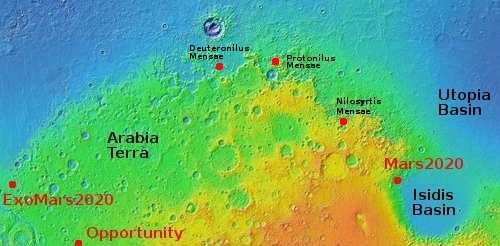
Isidis Basin, on whose margin Perseverance will roam

Pedestal craters in Isidis Basin
Click for full image.

Overview map

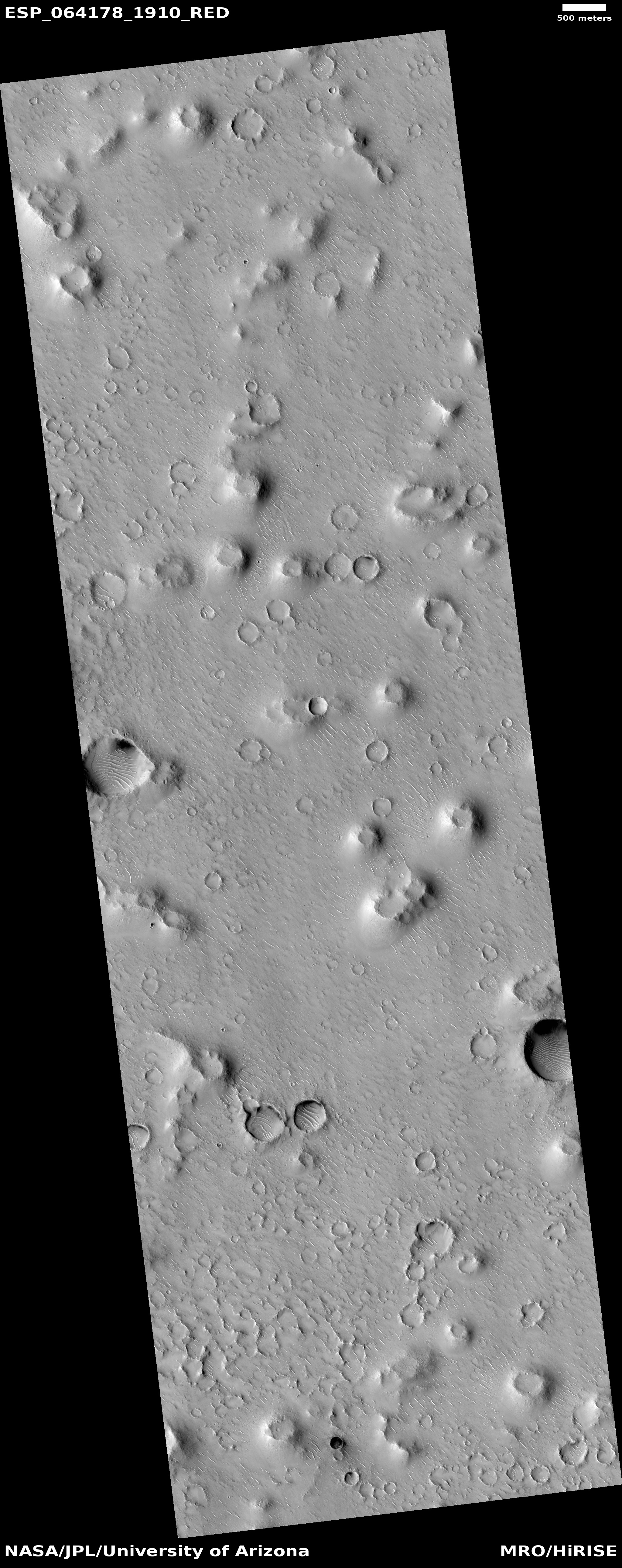
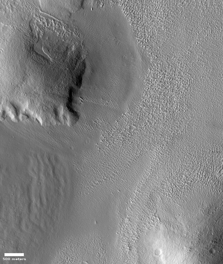
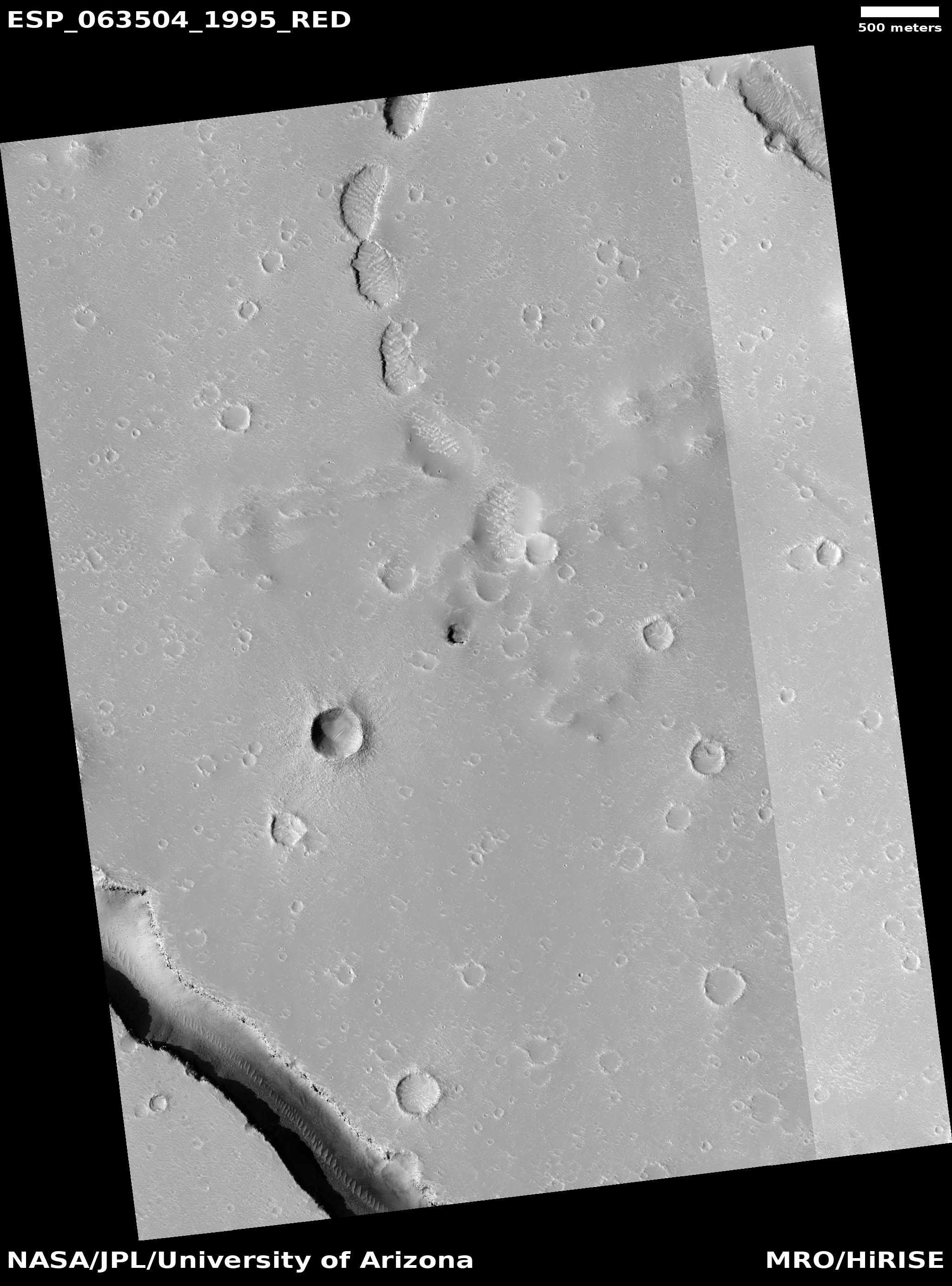
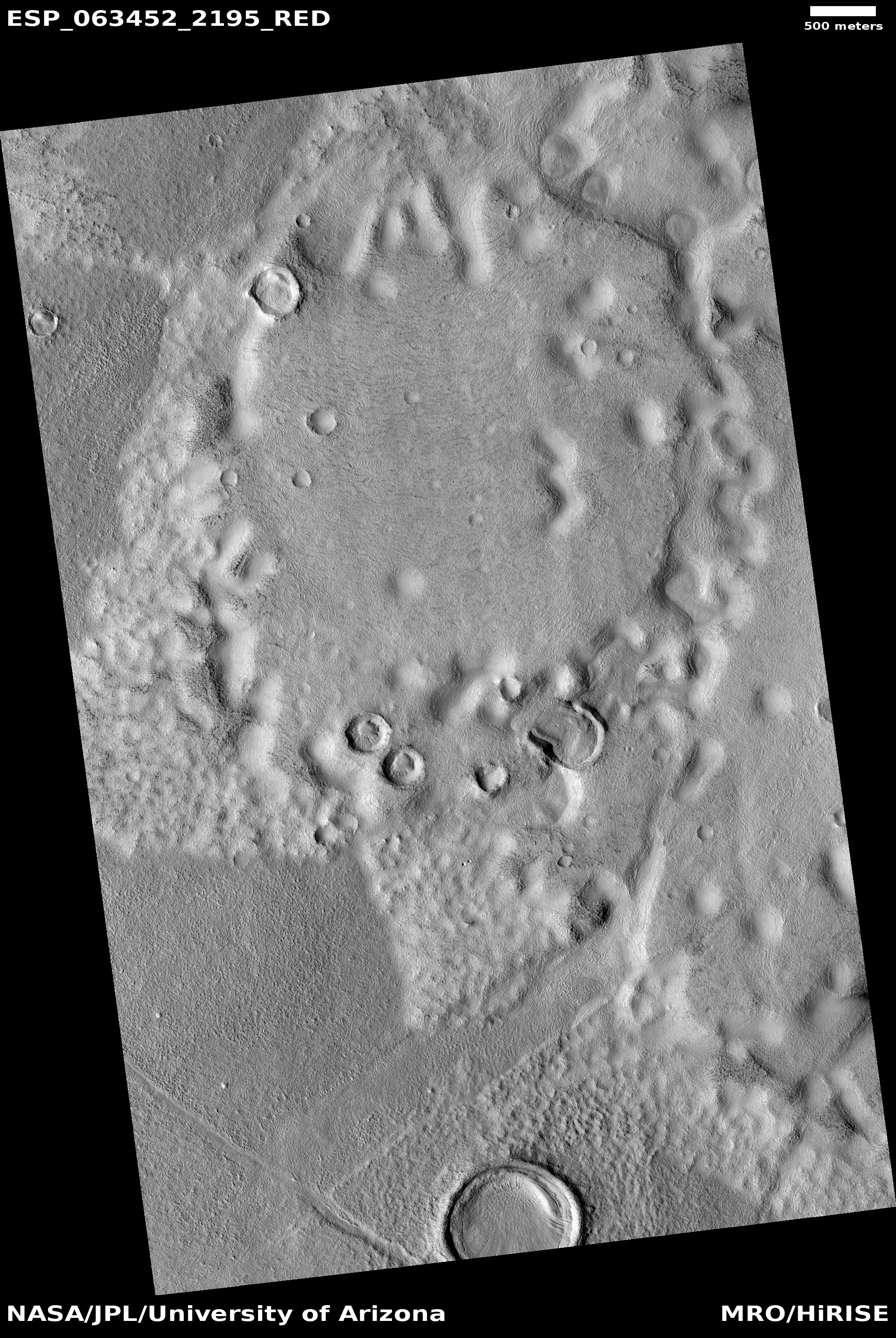
Today’s cool image to the right, cropped and reduced to post here, highlights the floor of one of Mars’ largest basins, dubbed Isidis Planitia, and located at the transition zone between the planet’s northern lowland plains and the southern cratered highlands.

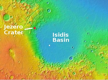
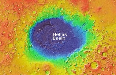
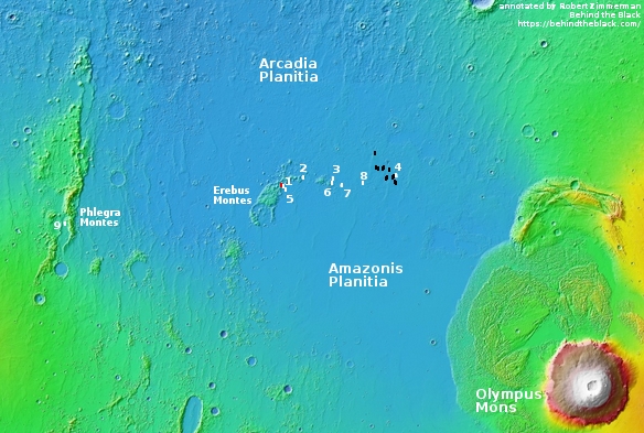
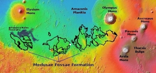
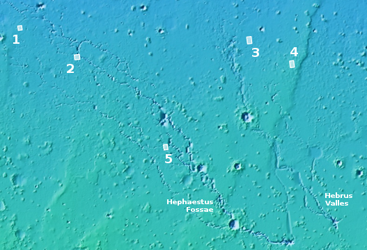
The overview map below of Isidis Basin provides some context. The white box shows where this particular image is located. Jezero Crater, indicated by the red circle (which is also about the size of the crater), is where the rover Perseverance is going to land and roam come February 2021, should all go well. For scale, Isidis is about the size of the eastern half of the United States. If Chicago was located at Jezero Crater, Baltimore would be on the basin’s eastern edge, at around 4 o’clock.

This particular section of the full photo, taken on April 5, 2020 by the high resolution camera on Mars Reconnaissance Orbiter (MRO), shows many features very typical of the floor of Isidis Basin, which also immediately reveal a great deal about its possible history.

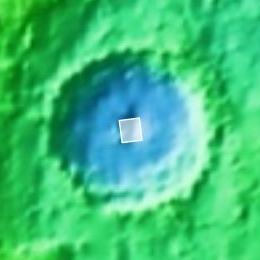
In this small snippet we can see what at first glance appear to be pedestal craters standing up like mesas, with ordinary craters scattered about on that lower surrounding terrain. Clearly, if these are pedestal craters they had to have been created first, and then over a very long time erosion processes ate away at that plain, leaving these pedestals (which had become resistant to erosion because the impact had packed their material together and made it harder) behind as mesas.

Then, after this period of erosion was complete enough additional time was required for at least one or two rounds of cratering to occur, leaving behind the many more younger craters on the plain floor, many of which are now partly buried by dust and sand.

The problem is that these mesas are almost certainly not pedestal craters, despite their appearance. » Read more

3 comments

Fading Martian slope streaks

Fading Martian slope streaks
Click for full image.

Cool image time! I’ve covered the topic of the mysterious slope streaks on Mars previously in great detail (see here and here). Essentially they are generally dark streaks (but sometimes light) that appear randomly on slopes and then fade over time. Unlike recurring slope lineae, another changing streak found on Martian slopes, the coming and going of slope streaks is not tied to the seasons. They can appear at any time in the year, and will take several Martian years to fade away.

The image to the right, rotated, cropped, and reduced to post here, was taken by the high resolution camera on Mars Reconnaissance Orbiter (MRO) on March 26, 2020. It shows numerous slope streaks down the eastern interior rim of a crater in the transition zone between the northern lowlands and the southern cratered highlands in a region dubbed Arabia Terra.

Though I can find no previous high resolution image of this crater to measure any temporal changes, you can clearly see that this slope has experienced many streaks over time, with some darker than others. The different shades suggest that the lighter streaks are older and have faded, with the darker streaks more recent events.

At the moment there is no strong consensus on the causes of these streaks. As one science paper noted, “The processes that form slope streaks remain obscure. No proposed mechanism readily accounts for all of their observed characteristics and peculiarities.” We know they occur in equatorial regions and dusty locations, and that they are triggered by some disturbance at the topmost point of the streak, which then causes a chain reaction down the slope. Other than that, the facts are puzzling, and suggest that these streaks are a phenomenon wholly unique to Mars.

The crater itself, located at 24 degrees north latitude, has some other mysteries. The features on its floor, for instance, are very puzzling. Though suggestive of the buried glaciers found in many craters in the mid-latitudes, this crater is a bit too far south. Maybe its higher altitude allows for some ice to remain here? Then again, the features on that floor might have nothing to do with ice. Maybe we are looking at sand carved by wind? Or hardened mud that was once wet?

I am merely guessing, a dangerous thing to do when one’s knowledge is limited. Then again, it’s fun, so please join in with your own guesses.

11 comments

An exposed dry waterfall on Mars

An exposed dry waterfall on Mars
Click for full image.

Close overview map

Wide overview map

Cool image time! The photo to the right, cropped and reduced to post here, was taken on April 30, 2020 by the high resolution camera on Mars Reconnaissance Orbiter (MRO). Uncaptioned, the science team titled the release as a “Cataract in Osuga Valles.”

To understand what we are looking at it is necessary to also see a wider view, as provided by the context map below and to the right. As you can see, this image straddles across the canyon called Osuga Valles, and heads downstream to the east. It also shows a point where the grade of that canyon suddenly drops. If water ever flowed here this place would have been the location of a truly spectacular waterfall.

More likely, these cataracts mark the location where sometime in the past a glacier had flowed down this valley, cutting a path until it broke out into the large and wide dead end area that appears to have no clear outlet. For some reason at this point the downhill grade of this canyon suddenly dropped, with the glacier following that sudden steep drop.

There is no glaciers here now, as this location is at 14 degrees south latitude, too close to the equator for any ice to remain close to the surface. Instead, dust dunes remain as the only feature flowing down through these cataracts.

The second overview map provides further context, showing the location of Osuga Valles relative to nearby Valles Marineris, the largest known canyon system in the solar system. Whatever process formed that gigantic canyon system certainly was a factor in forming Osuga Valles. The details however are not yet understood with any certainty. All we presently have are theories.

1 comment

The strange squashed ridges at the basement of Mars

Squashed ridges at the basement of Mars
Click for full image.

Overview map

Cool image time! The photo on the right, cropped and reduced to post here, was taken by the high resolution camera on Mars Reconnaissance Orbiter (MRO) on April 9, 2020, and shows the very weird and very packed ridges and layers that are found routinely at the deepest part of Hellas Basin, what I have dubbed the basement of Mars.

Be sure to click on the image to see the full photograph. There’s lots more strangeness to see there. And be sure to read my post in the second link, which highlights a similarly strange set of packed ridges, and where I note:

This is the basement of Mars, what could be called its own Death Valley. The difference however is that unlike Death Valley, conditions here could be more amendable to life, as the lower elevation means the atmosphere is thicker.

The context map to the right shows Hellas, with the location of today’s image indicated by the white box, close to basin’s lowest point, more than five miles below the basin’s rim. Overall the Hellas Basin is about the size of the western United States, from the Mississippi River to the Pacific Ocean. It is believed that the entire basin was created by a single gigantic impact that occurred about four billion years ago when the solar system’s inner planets were undergoing what has been labeled the Late Heavy Bombardment.

The specific process that formed these ridges, dubbed honeycomb terrain by scientists, remains unknown however. There are of course theories, none of which are very convincing. Here’s mine, as outlined in the previous post:
» Read more

4 comments

Thar’s ice in them Martian hills!

Icy mountains in Erebus Montes?
Click for full image.

Overview map of Starship landing site images

Cool image time! Today we return to the Erebus Mountains, located just to the west of SpaceX’s prime candidate landing site for Starship on Mars. The photo to the right, taken on April 4, 2020 by the high resolution camera on Mars Reconnaissance Orbiter (MRO) and rotated, cropped, and reduced to post here, shows one particular area between the peaks in those mountains, and also happens to be very close to what I have labeled image #1 in SpaceX’s Starship landing site photos.

The second image below and to the right shows an overview map of this region, with the SpaceX photos indicated by the numbered white boxes and the location of this image indicated by the red box, right next to image #1. The black boxes were images that SpaceX had obtained from MRO earlier, when it was first planning to send a Dragon capsule to Mars using a Falcon Heavy, a project the company has put aside in its focus on building Starship.

To my eye, everything in the first image above reeks of an icy, glacial terrain. I certainly am guessing, but it is an educated guess based on looking at numerous similar images in this region (see here and here, ) as well as in the nearby Phlegra mountains to the west. I also base my guess on what I have learned interviewing planetary scientists who are studying these images. The reasonableness of this guess is further strengthened in that the location is at 39 degrees north latitude, dead center in the mid-latitude bands where scientists have found evidence of numerous buried glaciers.

If Starship lands just to the east of the Erebus Mountains, the first colonists will likely not only have water available at their feet close to the surface in the flat lowland plains, if they find that resource insufficient they will need only climb uphill a bit into these hills to dig out as much ice as they could ever need.

0 comments

A Martian crater with a straight edge

A mis-shapened crater on Mars
Click for full image.

Cool image time! The image to the right, cropped and reduced to post here, was released today by the science team of the high resolution camera on Mars Reconnaissance Orbiter (MRO). It shows a small Martian crater whose northern rim for some reason is flattened into a straight line. Such a crater is rare, since almost all craters rims are round, even in the case of a low angle impact. The cause is unknown, though there are theories. From the caption, written by Ingrid Daubar of the Lunar and Planetary Laboratory in Arizona:

One possibility is that there was a zone of joints or faults in the crust that existed before the impact. When the impact happened, the crater formed along the straight line of these faults. Something similar happened to Meteor Crater in Arizona. Our image doesn’t show any faults, but they could be beneath the surface.

Perhaps some sort of uneven collapse changed the shape of the crater. There are piles of material on the crater’s floor, especially in the northwest and northeast corners. If those piles fell down from the rim, why did it happen there and not in other places? This crater is near the size where larger craters start to show wall slumping and terraces, so this type of collapse could be occurring unevenly.

The crater is located in the southern cratered highlands of Mars, at about 32 degrees latitude. At that latitude, it is also possible that some past glacial activity could have misshapen this crater, though I have no idea how. The crater itself does not appear to have any glacial material in it.

3 comments

Weird central peak in Martian crater

Textured central peak in Martian crater
Click for full image.

Cool image time! The photo to the right, cropped to post here, was taken by the high resolution camera on Mars Reconnaissance Orbiter on March 18, 2020. It shows a very strange central peak in a crater on Mars. Not only does this peak stick out like a sore thumb in a relatively flat crater floor, its surface is strangely textured, patterned with what look like scallops.

The overview map below shows the area covered in the crater by the full image.

My guess is that the peak is the final impact melt from the original impact. Think of a pebble thrown into a pond. You get ripples (the crater rim) as well as an upward drop of water (the central peak). Unlike pond water, the material in a crater freezes quickly, leaving both the ripple and the upward drop frozen in place.

Close overview of crater

This peak however also reminds me of volcanic cones found in the American southwest, the remnant cone of a much larger volcano that has long ago eroded away.

The textures might be evidence of that erosion process, as they resemble scallops that wind and water erosion can cause on rock faces.

We also could be seeing dunes on the slopes themselves, though I think this is unlikely. This crater is on the edge of the vast Medusae Fossae Formation, the largest volcanic ash deposit field on Mars, as shown by the white cross on the overview map below. Thus, being on the edge of this ash field there is a lot of available dust and sand that can pile up on these slopes.

Wide Overview map

Still, the sunlight side of the ridge suggests the scallops are in bedrock, not sand dunes. And to assign their origin to either wind or water or ice erosion I think is a stretch.

So while the peak is probably the frozen melt remains of the original impact, the scallops are a geological mystery that needs unraveling.

2 comments

Amazing layers

Bedrock layering in Holden Crater
Click for full image.

Cool image time! The science team for the high resolution camera on Mars Reconnaissance Orbiter (MRO) today released a cool captioned image entitled “Exquisite Layering”, showing a place on the floor of Holden Crater where the dust and sand that normally covers most of the Martian surface has been wiped away, cleared off because these layers are on higher sloping terrain.

The image to the right, cropped to post here, focuses in on that exposed layering, believed to be sedimentary and must have therefore happened in the eons following the impact that caused the crater.

Overview map

The overview map to the right shows with the red box the location of this layering inside Holden Crater. The map also illustrates why this crater was considered a candidate landing site for Curiosity. Like Gale Crater, it has evidence — the large meandering canyon system flowing into the crater — that suggests it had once been filled with a water lake. These sedimentary layers support that hypothesis, suggesting that this lake was intermittent. Each time it refilled and then dried up, it laid down a new deposit of those sedimentary layers.

0 comments

More pits found on Mars

Pit near Hephaestus Fossae
Click for full image.

Overview map

Since 2018 I have made it a point to document every new pit image taken on Mars by the high resolution camera on Mars Reconnaissance Orbiter (MRO). The list of can be found at the bottom of this post.

In the most recent release from MRO, a number of new pits were photographed. All continue to suggest that Mars has a lot of underground voids, some caused by lava flow, some by tectonic activity, some by water ice erosion, and some almost certainly caused by processes we don’t yet know. The images also suggest that we have only identified a small fraction of those underground voids.

The first image to the right, cropped to post here, shows the one new pit in the northern lowlands of Utopia Planitia, near a series of meandering channels and canyons dubbed Hephaestus Fossae and Hebrus Valles.

This appears to be the fifth such pit found in this region. Previously I had documented the first four. The overview map to the right adds this fifth pit. Note how the pit is much closer to the head of Hephaestus. In the full image you can see fissures both to the north and south, as well as many nearby aligned depressions, suggesting the existence of more underground passages, some possibly linked to voids under this very pit.

The pit itself seems filled, with no apparent side passages, though to the southwest there might be something leading off in the shadows.

The overall terrain in this region, including these pits, the fissures, and the many aligned depressions, strongly suggests a lot of underground voids. As I noted in 2019:
» Read more

14 comments

A shadowed ice patch on Mars

A shadowed ice patch on Mars
Click for full image.

Cool image time! The evidence coming back from Mars in the past two decades has increasingly suggested that there is a lot of water in that planet’s mid- and high latitudes. In the mid-latitudes the evidence suggests that ice is locked in a lot of buried and inactive glaciers that were laid down during periods when the planet’s rotational tilt, its obliquity, was greater so that the annual seasons were more extreme. During those times the mid-latitudes were colder than the poles, and water was being transferred from the poles to those mid-latitudes.

The image to the right appears to be more such evidence. Taken on March 21, 2020 by the high resolution camera on Mars Reconnaissance Orbiter (MRO) and cropped and brightened by me to bring out the important details, it shows what looks to be a distinct patch of ice on the south-facing slope of the rim of a large crater. Since this crater is in the southern mid-latitudes (34 degrees south), that south-facing slope generally gets much less sunlight, even in the summer, so any remaining buried glacial ice on that slope will linger for a longer period.

Think of the lingering ice and snow patches on shadowed locations on Earth. Because the Sun does not directly shine on them, they will be the last patches to melt away.

What I think is likely important about this patch are the exposed layers along its edge. These are the spots that are melting first, as they are where the ice is exposed, unprotected by a layer of dust and debris. It is also here that we have a window into that geological history. Even at this resolution you can see that the ice was laid down in layers, meaning that it contains evidence of those repeated climate cycles produced by Mars’ shifts in obliquity.

Those layers even seem to show the same sharp and sudden change from brighter and dirtier layers, as seen in the layers of the north pole ice cap, that occurred about 4.5 million years ago.

How tantalizing. The entire climate history of Mars is sitting there for us to decipher. We need only drill a few core samples and voila! the pieces of that history will start to fall into place.

4 comments

The edge of an eroded buried Martian glacier

The edge of an eroded buried Maritian glacier
Click for full resolution image.

Overview

Cool image time! The image to the right, rotated, cropped, and reduced to post here, was taken by the high resolution camera of Mars Reconnaissance Orbiter (MRO) on April 6, 2020.

The image shows the dying edge of a debris flow coming down from a mesa, the edge of which can be seen as the dark slopes in the upper left. The white arrows point up slope. It is located in the chaos terrain of a mid-latitude region called Deuteronilus Mensae, in the transition zone between the southern highlands and northern lowlands, where many such glacial-like features are found. I featured a similar nearby glacial edge only two months ago, where the image showed the glacier’s break up and collapse at its edge.

Here, the debris flow isn’t breaking up so much as crumbling away, its edge a line of meandering depressions, with the uphill slope covered with many knobs and tiny depressions, reminiscent to me of the many features I see in caves, where the downward flow of water shapes and erodes everything to form cups and holes and knobs, all the same size. If you click on the full resolution image and zoom into that debris slope and then compare it with the linked cave formation photo, you will see the resemblance.

We are almost certainly looking at a buried inactive glacial flow coming off that mesa, though it appears to be eroding at its foot. The overview image to the right shows the context, with the red dots indicating this image as well as similar features in adjacent mensae regions (featured in the linked images above). While the chaotic and rough terrain found along this transition zone does not make them good first settlement sites, the ample evidence of vast reservoirs of buried ice, combined with a variety of topography, will likely someday make this good real estate for those living on Mars.

3 comments

The blobby wettish flows of Mars

flow-like feature in Utopia Planitia
Click for full image.

Cool image time! Rather than talk about shut downs, lying politicians, and our tragically fear-filled society, let’s go exploring on Mars. The image to the right, rotated, cropped, and reduced to post here, was taken by the high resolution camera on Mars Reconnaissance Orbiter (MRO) on February 8, 2020. Dubbed a “Flow-Like Feature within the Adamas Labyrinthus”, it shows what appears to be a very distorted and eroded pedestal crater surrounded by strange triangular-shaped flow features.

It also shows, as does much other research, that the northern mid-latitudes of Mars have a lot of frozen water, much of it buried very close to the surface.

Assuming this is a pedestal crater (which it might not be), this feature has to be very old. Pedestal craters require age, as to stand out above the surrounding terrain a lot of time is needed to erode that terrain away. This age is confirmed by the bunch of newer craters on top.

At the same time, the partially filled small crater near its bottom, as well as the soft eroded depressions on top, suggest that much of this surface has been reshaped by more recent flows, changing its shape over time.

The surrounding triangular flows probably occurred at the original impact, and suggest that there is ice near the surface, making the material here act almost like wet mud when heated. Since this location is right in the middle of the mid-latitude bands where scientists have found lots of evidence of buried glaciers and ice near the surface, this supposition seems reasonable.

The overall location provides some further context.
» Read more

0 comments
1 69 70 71 72 73 90