More polygons on Mars!

Lava polygons on Mars?
Click for full image.

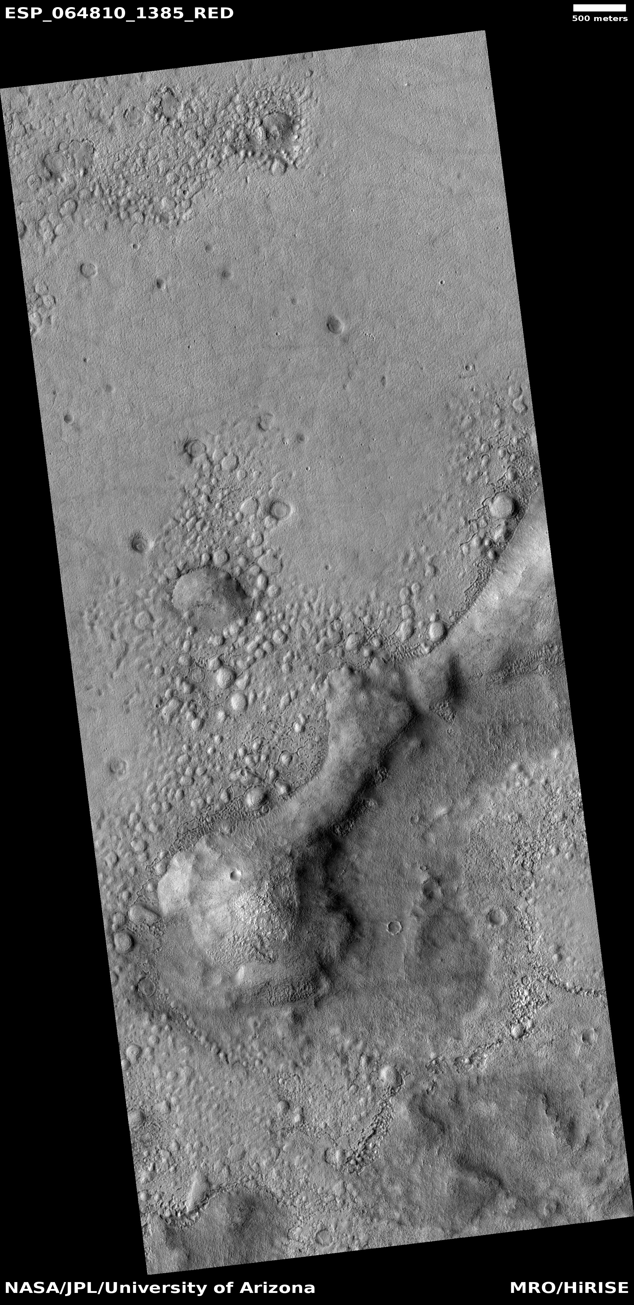
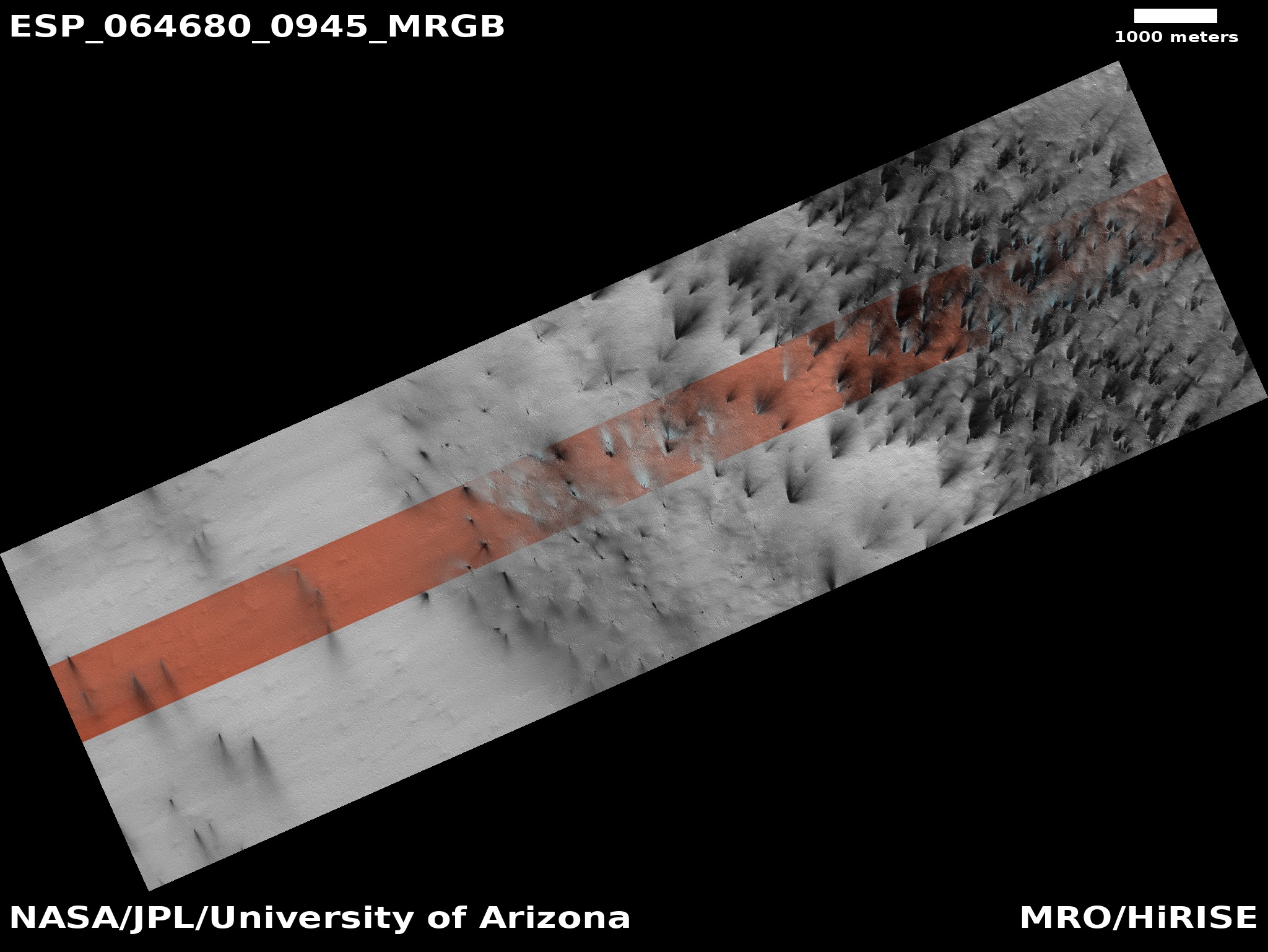
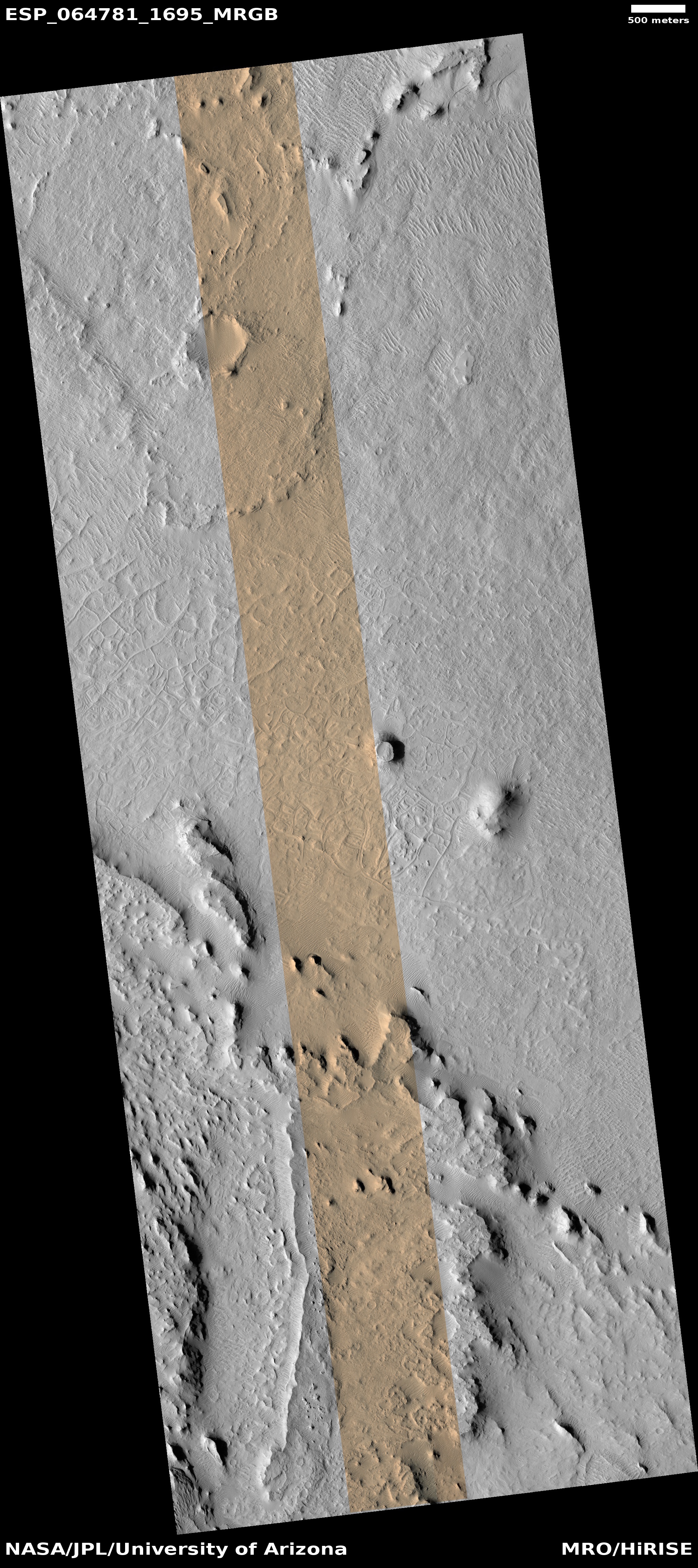
Today’s cool image, rotated, cropped, and contrast-enhanced to post here, focuses on polygons found near the equator of Mars. It was taken by the high resolution camera on Mars Reconnaissance Orbiter (MRO) on May 22, 2020, and shows what the science team labels as “well-preserved polygons.”

Previously I have posted cool images showing polygons (here and here), but those images were located in the northern mid-latitudes, and were thought to have been formed in connection with some form of freeze-melt-drying water process in permafrost.

Today’s image however is likely not related to water. It is located in the equatorial regions, where little water is expected. It also has a more permanent nature, which suggests that it is the result of some sort of volcanic or tectonic process. That the polygons are depressions suggests the latter, since a volcanic process is more likely to have filled cracks and left ridges more resistant to erosion, as explained by this article.

In this case the topography suggests instead some form of spreading and cracking process that left behind these polygon-shaped cracks. In mud, such polygons are found when the mud dries, but once again, these are in a very dry region. If formed in that manner they must have formed a very very long time ago, when the climate here was very different, and were somehow preserved for eons since.

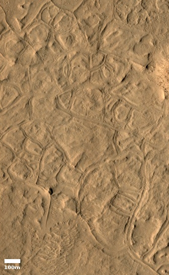
The location, as shown in the overview map below provides some context, though it really doesn’t answer any questions..
» Read more

Launch update on Mars missions

The launch status of the three missions to Mars:

First, the launch of UAE’s Hope orbiter by Mitsubishi’s H-2A rocket has been pushed back to July 20th due to bad weather. Their launch window extends to August 3rd, so they still have two weeks before it closes.

Second, China has rolled to the launchpad the Long March 5 rocket, with the Tienwen-1 orbiter/lander/rover. Though they have only said that the launch will occur between July 20th and July 25th, based on past operations, they usually launch six days after roll-out, putting the launch date as July 23.

China has also provided some clarity as to Tienwen-1’s landing site on Mars. According to this Nature Astronomy paper [pdf], published on July 13th, their primary landing site is in the northern lowland plains of Utopia Planitia. The Tienwen-1 science team has also considered [pdf] the northern lowland plains in Chryse Planitia, on the other side of Mars.

Since they will spend two to three months in Mars orbit before sending the lander and rover to the surface, it could very well be that they won’t make a final decision until they get into orbit.

Finally, on July 7th Perseverance was mounted on top of its Atlas-5 rocket for its July 30th launch. Its launch window closes on August 15.

NASA confirms Webb launch delay to October 2021

NASA today confirmed that the launch date of the James Webb Space Telescope will be delayed again, from March 2021 to October 2021.

As schedule margins grew tighter last fall, the agency planned to assess the progress of the project in April. This assessment was postponed due to the pandemic and was completed this week. The factors contributing to the decision to move the launch date include the impacts of augmented safety precautions, reduced on-site personnel, disruption to shift work, and other technical challenges. Webb will use existing program funding to stay within its $8.8 billion development cost cap. [emphasis mine]

Note the highlighted words. Vague, eh? They are trying to make it seem that this new delay is solely because of the Wuhan virus panic, but that’s simply not justifiable. Notice how SpaceX has kept on launching Falcon 9s as well as testing new Starship prototypes throughout the panic. Somehow that private company was able keep its schedule going.

The truth is that as early as January, long before COVID-19 was even a blip on the horizon, the GAO was warning everyone that it was unlikely NASA and Northrop Grumman could meet the March 2021 launch date.

Webb is now more than a decade behind schedule, and once launched will have cost 20 times what it was originally budgeted ($500 million vs $10 billion). Let us pray that it works once it gets to is proper orbit, a million miles from Earth, since it will then be too far away to fix.

Starship prototype being prepped for first hop

Capitalism in space: SpaceX engineers, having successfully completed its tank pressure tests of its fifth Starship prototype, are now preparing the ship for its first static fire engine test, to be followed very quickly thereafter by its first hop to 150 meters.

SN5 [the fifth prototype] is being prepped for a flight test right out of the gate. SpaceX does not plan to perform an extended ground test campaign with SN5 after beginning Raptor engine testing.

It is understood that one good static fire test could be enough to clear the way for a 150-meter hop test. Furthermore, only a few days may be required to prepare SN5 for the flight test following a successful static fire test. If a static fire occurs this weekend, this will put the earliest possible hop date in the first half of next week.

As always, this schedule could change during testing.

The article also describes the status of both the sixth prototype, as well as the eighth being assembled now, noting that “if the 150-meter flight of Starship SN5 is successful, SpaceX is expected to quickly move on to Starship SN8 for an upcoming higher altitude flight test – potentially skipping a flight test with the SN6 prototype.”

Solar Orbiter’s first images, the closest ever of Sun

Campfires on Sun
Click for full image.

The Solar Orbiter science team today released the first images taken during the spacecraft’s first close fly-by of the Sun.

The image to the right, reduced to post here, highlights what they are touting as their first discovery, what they have dubbed “campfires” on the solar surface, small flares previously not known to exist.

The campfires shown in the first image set were captured by the Extreme Ultraviolet Imager (EUI) from Solar Orbiter’s first perihelion, the point in its elliptical orbit closest to the Sun. At that time, the spacecraft was only 77 million km away from the Sun, about half the distance between Earth and the star. “The campfires are little relatives of the solar flares that we can observe from Earth, million or billion times smaller,” says David Berghmans of the Royal Observatory of Belgium (ROB), Principal Investigator of the EUI instrument, which takes high-resolution images of the lower layers of the Sun’s atmosphere, known as the solar corona. “The Sun might look quiet at the first glance, but when we look in detail, we can see those miniature flares everywhere we look.”

The scientists do not know yet whether the campfires are just tiny versions of big flares, or whether they are driven by different mechanisms. There are, however, already theories that these miniature flares could be contributing to one of the most mysterious phenomena on the Sun, the coronal heating.

Much more to come in future orbits, as the spacecraft works its way even closer to the Sun.

Seismic signal from recent Martian impact detected by InSight?

According to a science paper released today, a small impact that occurred about 25 miles south from the InSight lander between February 21st and April 6, 2019 might have been detected by the spacecraft’s seismometer.

From the paper’s abstract:

During this time period, three seismic events were identified in InSight data. We derive expected seismic signal characteristics and use them to evaluate each of the seismic events. However, none of them can definitively be associated with this source. Atmospheric perturbations are generally expected to be generated during impacts; however, in this case, no signal could be identified as related to the known impact. Using scaling relationships based on the terrestrial and lunar analogs and numerical modeling, we predict the amplitude, peak frequency, and duration of the seismic signal that would have emanated from this impact. The predicted amplitude falls near the lowest levels of the measured seismometer noise for the predicted frequency. Hence it is not surprising this impact event was not positively identified in the seismic data.

Based on this data, they now think they will only be able to detect about two impacts per year with InSight’s seismometer, a decrease from the previous estimate of as many as ten.

Martian acne?

Acne on Mars?
Click for full image.

Cool image time! The photo to the right, rotated, cropped, and reduced to post here, shows what the scientists from the high resolution camera on Mars Reconnaissance Orbiter (MRO) label “fretted terrain.” In an earlier post describing evidence found by Europe’s Mars Express orbiter of glaciers in the northern mid-latitudes of Mars, fretted terrain was described as follows:

As is common with fretted terrain, it contains a mix of cliffs, canyons, scarps, steep-sided and flat-topped mounds (mesa), furrows, fractured ridges and more, a selection of which can be seen dotted across the frame.

These features were created as flowing material dissected the area, cutting through the existing landscape and carving out a web of winding channels. In the case of Deuteronilus Mensae, flowing ice is the most likely culprit. Scientists believe that this terrain has experienced extensive past glacial activity across numerous martian epochs.

In that case the fretted terrain was in the transition zone between the northern lowland plains and the southern cratered highlands, and actually resembled chaos terrain. What we see here looks far different, a surface that resembles the bubbly surface of a vat of thick molten stew.

This image is also deep in the cratered southern highlands, though still in the mid-latitudes at 41 degrees south latitude. While the presence of ice close to the surface is possible at this latitude and could definitely explain what this image shows, it would be a big mistake to accept this explanation without skepticism. A lot is going on here, and much of it suggests volcanic-type processes. The volcanoes might have been spewing mud or ice instead of molten lava, but then again, all is uncertain.

What is certain is that I can’t help thinking of the pock-marked skin of an adolescent teenager when I look at this photo. And for all we know, the processes that produce both surfaces could be in many ways similar.

Northrop Grumman launches U.S. reconnaissance satellites

Capitalism in space: Northrop Grumman today successfully used its Minotaur-4 rocket to launch four U.S. reconnaissance satellites for the National Reconnaissance Office.

Minotaur-4 is essentially re-purposed military ICBM that had been decommissioned, refurbished, and upgraded for orbital flight. This was its first launch from Wallops Island in Virginia. This was also Northrop Grumman’s second launch this year, which still leaves them out of the 2020 launch race leader board:

16 China
10 SpaceX
7 Russia
3 ULA

Today’s launch however puts the U.S. ahead of China in the national rankings, 17 to 16.

Midnight repost: The Lie that is Orion

The tenth anniversary retrospective of Behind the Black continues: This essay, written in July 2016, might provide modern readers with some background and context into the uselessness of NASA’s over priced, over designed, and behind schedule Orion capsule. The only thing that has changed in the four years since is that NASA has stopped claiming Orion is an interplanetary spaceship. They now freely admit that to get to Mars they need to build and assemble much larger ships, of which Orion will only be a tiny part.

————————-
The Lie that is Orion

Several weeks ago NASA put out one of its periodic press releases touting the wonders of the engineering the agency is doing to prepare for its future missions to Mars. In this case the press release described a new exercise device, dubbed ROCKY (for Resistive Overload Combined with Kinetic Yo-Yo), for use in the Orion capsule.

“ROCKY is an ultra-compact, lightweight exercise device that meets the exercise and medical requirements that we have for Orion missions,” said Gail Perusek, deputy project manager for NASA’s Human Research Program’s Exploration Exercise Equipment project. “The International Space Station’s exercise devices are effective but are too big for Orion, so we had to find a way to make exercising in Orion feasible.

As is their habit these days in their effort to drum up support for funding for SLS and Orion, the press release was filled with phrases and statements that implied or claimed that Orion was going to be the spacecraft that Americans will use to explore the solar system.

…engineers across NASA and industry are working to build the Orion spacecraft and Space Launch System rocket that will venture to deep space for the first time together…

…Over the next several years, NASA’s Human Research Program will be refining the device to optimize it not only for near-term Orion missions with crew, but for potential uses on future long-duration missions in Orion…

These are only two examples. I have clipped them because both were very carefully phrased to allow NASA deniablity should anyone question these claims. For example, in the first quote they qualify “deep space” as specifically the 2018 unmanned lunar test flight. And the second quote is qualified as referring to missions to lunar space. Nonetheless, the implied intent of this wording is to sell Orion as America’s interplanetary spaceship, destined to take us to the stars!

Don’t believe me? Then take a look at NASA’s own Orion webpages, starting with the very first words on their Orion Overivew page.
» Read more

Monument Valley on Mars

Monument Valley on Mars
Click for full image.

Today’s cool image is located near the Martian equator, in the middle of Arabia Terra, the most extensive region of the transition zone between the low northern plains and the southern cratered highlands. Taken on May 9, 2020 by the high resolution camera on Mars Reconnaissance Orbiter (MRO) and cropped to post here, the photo shows some layered mesas surrounded by a terraced and scalloped terrain with dust filling the low spots.

This is likely to be a very dry place on Mars. At only 2 degrees north of the equator, the evidence so far suggests that if there is a buried ice table (like the water table on Earth), it will be much deeper than at higher latitudes. The terrain reflects this, looking reminiscent of Monument Valley in the American southwest. In fact, the satellite image below, which I grabbed from MapQuest, shows a typical mesa in Monument Valley.
» Read more

More indications of the decline of Russia’s space effort

Two stories today give further hints that Russia’s space effort, run under the centralized government control of its space agency Roscosmos, is struggling. Both stories involve comments by the head of Roscosmos, Dmitry Rogozin, during an interview yesterday to celebrate the fifth anniversary of the Putin government’s takeover of Russia’s entire aerospace industry.

First, Rogozin announced that they intend to continue using their Soyuz manned capsule for at least ten more years, even though they are working to develop the Oryol replacement capsule and hope to fly its first unmanned test flight by 2023.

“I am absolutely sure that the Soyuz MS will be exploitable for at least ten years. That is why, during the first years we will use both the Soyuz MS and a new spacecraft,” he said.

Though it makes sense for Russia to fly both spacecraft for a period of time, ten years seems exorbitant. It suggests that Rogozin is covering his behind in case Oryol ends up getting delayed significantly.

Based on Russia’s track record the past twenty years, it is very likely Oryol will not fly by 2023. Since the turn of this century they have been promising new spacecraft and rockets without ever delivering. They have also spent a quarter of a century building one module for ISS. It has become their mode of operations to go slow and not deliver. Rogozin must know this, and is covering his bets by announcing Soyuz that will fly for many more years.

Second, Rogozin made it a point to denigrate the U.S. manned space effort, calling it a “political project” not interested in “helping” its partners. To quote him precisely:
» Read more

Launch delays for SpaceX and UAE

The launches planned for tomorrow by SpaceX and Japan’s space agency JAXA have both been postponed, for different reasons.

The SpaceX launch of a South Korean military satellite was postponed in order to swap out equipment in the Falcon’s upper stage. No new launch date has yet been announced.

The JAXA launch, using Mitsubishi’s H-2A rocket, was to launch the United Arab Emirates’ Mars orbiter Hope. It was postponed due to bad weather. Their next launch window is July 16, but they have not yet announced a new launch date. Like Perseverance, they must launch this summer or they will have to wait two years for the next launch window to Mars to reopen.

In-flight camera analysis of Soyuz launch abort in October 2018

An evening pause: For the geeks who read Behind the Black. Nothing here is new, but the in-flight footage of the first stage as it failed during this manned Soyuz launch on October 11, 2018 is still fun to watch, and it gives us another taste of the continuing quality control problems in Russia’s aerospace industry.

Hat tip Tom Biggar.

As always, I am open to suggestions for my evening pauses. If you’ve sent me stuff in the past, you know the drill. If not and you want to suggest something, post a comment here, without mentioning your suggestion, and I will contact you with the guidelines.

Martian swirls and curlicues

glacial features in depression on Mars
Click for full image.

Cool image time! The photo to the right, cropped and reduced to post here, is a great example of how a well known geological process on Earth, glaciers, can form features on Mars that appear most inexplicable.

The image was taken on May 13, 2020 and highlights the geology found in a depression, likely an eroded crater, on the northwest flanks of one of Mars’ largest basins, Argyre Planitia, located in the planet’s southern cratered highlands. The basin is thought to have been formed by a giant impact during the Late Heavy Bombardment around 3.9 billion years ago, when the inner terrestrial planets were sweeping up the last remnants of the Sun’s accretion disk, with that process causing the many craters we see on the Moon, Mercury, and Mars

This particular depression is at 41 degrees south latitude, in the mid-latitudes where scientists have found much evidence of buried glaciers. This is likely what we are looking at here. The section I’ve cropped has a dip to the south, which somewhat fits these flow features. If you look at the full image, you will see comparably weird flow features south of this section, flowing downhill in the opposite direction, to the north.

The problem is that not all the features fit the direction of flow, or any flow at all. I suspect we are seeing evidence of the waxing and waning of glaciers over this terrain over many eons. Disentangling that history however is confounding, especially when we are limited to only studying such objects from orbit.

I must also add that this image was labeled by the MRO science team a “terrain sample,” which means it wasn’t specifically requested by any scientist studying this geology. Instead, they needed to take an image to maintain the spacecraft’s camera temperature, and picked this spot for that snapshot. Their choice wasn’t random, but it also wasn’t based on any focused research.

SpaceX about to set reuse record for fastest turnaround ever

Capitalism in space: If tomorrow’s launch of a South Korean military satellite by SpaceX’s Falcon 9 rocket succeeds, it will set a new all-time record for the fastest turnaround of a used rocket, 44 days.

The previous record was 54 days, set by the space shuttle Atlantis in 1984. The article notes however the spectacular differences:

By far the most impressive aspect of Falcon 9’s imminent record is the comparison between the resources behind Space Shuttle Atlantis’ 54-day turnaround and Falcon 9 booster B1058’s ~44-day turnaround. Around the time NASA and Atlantis set the Shuttle’s longstanding record, some 5000-10000 full-time employees were tasked with refurbishing Space Shuttles and the facilities (and launch pads) that supported them. Based on retrospective analyses done after the STS program’s end in 2011, the average Space Shuttle launch (accounting for the vast infrastructure behind the scenes) ultimately wound up costing more than $1.5 billion per launch – more than the Saturn V rocket the Shuttle theoretically replaced.

According to a uniquely detailed May 2020 AviationWeek interview with SpaceX CEO Elon Musk, Falcon 9 booster turnaround may cost as little as $1 million apiece and can be managed from start to finish by several dozen employees at most. In other words, even though SpaceX boosters are suborbital and stressed quite a bit less than orbital Space Shuttles, Falcon 9 reuse is approximately a thousandfold more efficient that Space Shuttle reuse. [emphasis in original]

I should add that SpaceX also has three more launches on tap for the rest of July. If all lift off, the company will have launched four rockets in only three weeks, which in itself will be a record. No private rocket company has ever launched so frequently and so routinely. And only Russia during its Soviet Union heydays has come close to launching with this frequency.

Russia’s next module for ISS passes tests

At last! Russia’s long-delayed next module for ISS, dubbed Nauka, has finally passed its vacuum chamber tests and is now scheduled for shipment to the launch site on July 21 to 23.

Construction of Nauka began in 1995, a quarter of a century ago. For comparison, in the last quarter of the 20th century Russia launched Salyut 1, Salyut 3, Salyut 4, Salyut 5, Salyut 6, Salyut 7, Mir, and its first five modules for ISS. All told those launches involved building and putting into orbit 18 different modules, with 14 comparable to Nauka in size and mass, all built and launched in about the same amount of time it has taken Russia to build Nauka alone.

At this pace it will take centuries for Russia to build its next space station, no less get to the Moon or Mars.

Problems at Europa Clipper

NASA has fired the project scientist for one overbudget and behind schedule instrument on Europa Clipper, and restructured work on a second instrument for similar reasons.

“We’ve been struggling on cost growth on Clipper for some time,” said Curt Niebur, program scientist for the mission at NASA Headquarters. “Overall, we’ve been largely successful in dealing with it, but late last fall, it became clear that there were three instruments that experiencing some continued and worrisome cost growth.”

The outcome of the reviews, he said, could have ranged from making no changes to the instruments to, in a worst-case scenario, terminating the instruments. The leadership of NASA’s Science Mission Directive recently decided to keep all three instruments, at least for now.

The fired scientist had been in charge of the mass spectrometer. At the moment they have installed a temporary replacement, and have put the instrument team on notice that it now has a very low priority. Should it fall further behind in schedule or budget it could easily be terminated.

The spacecraft’s imaging system also has schedule and budgeting problems, so much so that NASA was considering dropping the wide field camera, leaving Europa Clipper with only a narrow field camera. Right now both have been retained, but the wide field camera might still be dropped if costs continue to rise.

A great hike to do on Mars!

Knife Mesa at the exit from Kasei Valles
Click for full image.

Time to take a cool image and go sight-seeing. The photo to the right, cropped and reduced to post here, was taken by the high resolution camera on Mars Reconnaissance Orbiter (MRO) on May 25, 2020, and shows a spectacular knife-edge mesa, its cliffs more than 650 feet high on either side.

This knife mesa sits among a bunch of similar mesas, and appears to be in a region that could be called chaos terrain, formed by flowing water or ice along faults, cutting criss-crossing canyons with mesas between.

This mesa points east out from the Kasei Valley, the second largest canyon draining out from the Tharsis Bulge that contains Mars’ largest volcanoes. The overview map below provides some context, with the white cross indicating the location of today’s cool image.
» Read more

COVID-19 and launchpad issues delay Ariane 6

The European Space Agency (ESA) confirmed today that the first launch of Arianespace’s Ariane 6 rocket will be delayed at least six months, to late 2021, due to lock downs related to the Wuhan flu panic, as well as construction issues at the rocket’s new launchpad.

“While we know that the maiden flight will not take place before the second semester of 2021, we cannot at this moment precisely quantify the delay, and we cannot provide an exact launch date,” Daniel Neuenschwander, ESA’s director of space transportation, said according to an ESA translation of remarks at a July 9 press event provided to SpaceNews. The French Association of Professional Journalists in Aeronautics, organized the event at ArianeGroup’s headquarters in Paris.

ESA hopes to have greater clarity on the delays in a few months, he said, according to the ESA translation.

It bodes bad for this rocket that they, at this time, have so little handle on the issues and the length of the delays.

Launch failure for China’s new Kuaizhou-11 rocket

For reasons not yet specified, China’s new Kuaizhou-11 rocket today failed on its inaugural launch.

Many reports will say that this is a commercial rocket developed by the private company Exspace. That is not true. Like all Chinese aerospace companies, they do their work wholly under the supervision of the Chinese government.

The development of the KZ-11 began in 2015, with a maiden launch originally scheduled for 2018. The rocket is developed by China Aerospace Science and Technology Corporation (CASIC) and commercialized by the China Space Sanjiang Group Corporation (Expace).

The launch vehicle can loft a 1,500 kg payload into a Low Earth Orbit (LEO) or 1,00 kg to a 700 km sun-synchronous orbit.

The KZ-11 solid launch vehicle adopts a mobile launch platform, integrated power supply equipment, test and launch control facilities, aiming facility and temperature control facility, to carry vehicles from the technical support center to launch site, complete temperature control of payload, vehicle test and launch.

CASIC is in many ways China’s equivalent of NASA. And everything described in the last paragraph above, from solid rockets to mobile launches, are technologies developed expressly for military purposes. China will not let such things out for commercial companies to use however they wish, no matter what they claim.

Falcon 9 landing leg falls during retraction

Capitalism in space: During the processing to bring a used Falcon 9 first stage back to its hanger after its June 30th launch, one of the landing legs unexpectedly fell back to the ground during retraction.

I have embedded the video of the incident, cued to the event, below the fold. No one was hurt, and it appeared that nothing was damaged. It appears it happened because a cable holding the leg vertical snapped just before the leg got latched in place on the side of the rocket.
» Read more

Solar Orbiter operational, first images to be released

Engineers have now confirmed that Solar Orbiter, having completed its first close fly-by of the Sun, is working perfectly and is producing images and data better than expected.

They will release to the public the first images on July 16.

“The first images are exceeding our expectations,” says Daniel Müller, Solar Orbiter Project Scientist at ESA. “We can already see hints of very interesting phenomena that we have not been able to observe in detail before. The 10 instruments on board Solar Orbiter work beautifully, and together provide a holistic view of the Sun and the solar wind. This makes us confident that Solar Orbiter will help us answer profound open questions about the Sun.”

No other images of the Sun have been taken from such a close distance. During its first perihelion, the point in the spacecraft’s elliptical orbit closest to the Sun, Solar Orbiter got as close as 77 million kilometres from the star’s surface, about half the distance between the Sun and Earth. The spacecraft will eventually make much closer approaches to the Sun. The spacecraft is now in its cruise phase, gradually adjusting its orbit around the Sun. Once in its science phase, which will commence in late 2021, the spacecraft will get as close as 42 million kilometres from the Sun’s surface, closer than the planet Mercury. The spacecraft’s operators will gradually tilt Solar Orbiter’s orbit to enable the probe to get the first proper view of the Sun’s poles.

A previous spacecraft, Ulysses, flew over the Sun’s poles, but it did it from far away, and was designed not to take images but to study the Sun’s solar wind. Solar Orbiter is getting in close.

Midnight repost: Mars!

The tenth anniversary retrospective of Behind the Black continues: Despite my many essays on culture and politics, Behind the Black remains mostly a site reporting on space and science. Since the modern exploration of Mars is probably the most significant on-going event now in space, it seemed unsatisfactory to only repost one or two of my past articles on this subject, when I have probably have posted hundreds. Instead, this midnight repost will provide links to a bunch, divided into several topics.

Martian geology, shown in cool images

First, we have the many cool images I have posted on Mars, often tied to detailed descriptions of what scientists are now beginning to learn about the red planet’s mysterious geological history. The following are the most important, and will help readers better understand future cool images.

Future colonization

Next, two posts, both focused on the future exploration and colonization of Mars.
» Read more

Spring at the Martian South Pole

Geysers on Mars?
Click for full image.

Geysers on Mars
Click for full image.

It is now full spring at the Martian south pole, and as should be expected much has been happening there. Like the Martian north pole, when sunlight arrives after the dark winter it hits the seasonally-placed mantle or cap of carbon dioxide snow and begins to melt it, in the alien ways things like this occur on Mars.

The two images to the right illustrate this process for one particular place located in what are called the south polar layered deposits. The two images, just released on July 1, 2020 from the high resolution camera on Mars Reconnaissance Orbiter (MRO) and taken on May 14 and May 30 respectively, had immediately caught my attention because they were labeled “Active Geyser Locale Dubbed Macclesfield.” Active geysers?! I immediately contacted Candy Hansen of the Planetary Science Institute in Tucson, Arizona, whom I correctly guessed had requested these photos. She explained,

The name for this site is of course informal, and it dates back to when I first started picking sites to monitor. I was so certain we would see active geysers here! We see their deposits, the fans on the surface, but so far we have not caught an actual eruption in progress.

The overview map of the south pole below provides some context.
» Read more

NASA completes Starliner review, finds more issues

Capitalism in space: NASA yesterday released the results of its investigation into the issues that prevented Boeing’s manned Starliner capsule from successfully completing its unmanned demo flight to ISS in December, finding an additional 20 issues over the 61 initially identified shortly after the mission.

In closing out the seven-month investigation, NASA officials said Tuesday they have now identified 80 corrective actions, mostly involving software and testing, that must be done before the Starliner capsule launches again. The previous count was 61.

NASA officials also admitted that they had been so focused on making sure SpaceX’s Dragon capsule was going to work that they became lax in reviewing Boeing’s work. Now they not only are going to focus more on Boeing, they actually want to use SpaceX’s approach to software development throughout NASA.

NASA is also borrowing SpaceX’s “robust” approach to software, which involves going back to the designers following testing for feedback, said Kathy Lueders, NASA’s new human spaceflight chief who until a month ago managed commercial crew. She wants to see more of that type of approach across other NASA programs.

Though it seems absurd and incredible that NASA has not been consulting with its designers after testing, it is also not surprising. When it comes to designing and building anything at NASA the management processes there have routinely done a bad job for many years.

As for Starliner, it is expected it will take a few more months to fix these issues, which means the next unmanned test flight is likely still set for sometime in the fall, with the manned mission to follow next spring.

Results from Yutu-2 determine “gel-like” rocks are impact melt

Chinese scientists have now published their analysis of the “gel-like” rocks seen by China’s Yutu-2 lunar rover back in October 2019, and have concluded that they are glasses produced from melt occurring during an impact.

The authors describe the material as a dark greenish and glistening impact melt breccia, measuring 20 inches by 6 inches (52 by 16 centimeters). These features are signs of possible presence of glasses, which are usually sourced from impact melts or from volcanic eruptions.

According to the paper, the breccia — broken fragment of minerals cemented together — was formed by impact-generated welding, cementing and agglutinating of lunar regolith and breccia. The material, they say, resembles lunar impact melt breccia samples returned by NASA’s Apollo missions. In particular, similarities with the Apollo samples designated 15466 and 70019 are noted, a comparison made earlier by lunar scientist Clive Neal at the University of Notre Dame. Sample 70019, collected by astronaut and trained geologist Harrison “Jack” Schmitt, is made of dark, broken fragments of minerals cemented together and black, shiny glass.

The results are not definitive, however. The paper notes that the analysis is limited by the fact that VNIS measurements were taken under bad illumination conditions and other factors.

This conclusion is not surprising, as the rover has been traveling through a region dominated by impact ejecta.

InSight’s mole is bouncing again

Plan of action for InSight's mole

The engineering team for InSight’s German-built digging tool, dubbed the mole, yesterday reported that it is once again no longer driving into the ground.

Previously they had been able to make progress by having InSight’s scoop press down on the mole. Once the top of the mole however was below ground, the scoop could no longer provide that support, and at that point the mole began bouncing again with each hammer-stroke, the surrounding Martian dirt unable to provide the friction to hold the mole down.

As shown by the illustration above, they are now going to try using the scoop to fill the hole and then use the scoop to press down on the dirt, with the hope this will provide the structural friction required to hold the mole in place after each hammer stroke. This effort will take time, and will prevent the scoop from doing its other work. They are therefore taking a pause until August before beginning the hole-filling operation.

Rover update: Curiosity’s future journey

Mount Sharp, with Curiosity's future travels
Click for full image.

[For the overall context of Curiosity’s travels, see my March 2016 post, Pinpointing Curiosity’s location in Gale Crater. For the updates in 2018 go here. For a full list of updates before February 8, 2018, go here.]

Today the science team of Curiosity issued a press release outlining their travel plans for the rover over the next year. In conjunction, they also released a mosaic of 116 images taken by the rover showing that route, a reduced in resolution version shown above.

The rover’s next stop is a part of the mountain called the “sulfate-bearing unit.” Sulfates, like gypsum and Epsom salts, usually form around water as it evaporates, and they are yet another clue to how the climate and prospects for life changed nearly 3 billion years ago.

But between the rover and those sulfates lies a vast patch of sand that Curiosity must drive around to avoid getting stuck. Hence the mile-long road trip: Rover planners, who are commanding Curiosity from home rather than their offices at NASA’s Jet Propulsion Laboratory in Southern California, expect to reach the area in early fall, although the science team could decide to stop along the way to drill a sample or study any surprises they come across.

Overview map sol 2804 of Curiosity's route

This journey actually began in late May, at about the time of my last rover update. The overview map to the right shows in red their approximate planned route to avoid that large dune field to the south. The meandering yellow line indicates Curiosity’s actual route. The straight yellow lines indicates I think the area covered by the mosaic above. As you can see, since the end of May they have quickly returned to their planned route. Note also that the dune field extends about twice the distance beyond the eastern edge of this overview map.

The next big goal when they reach that sulfate-bearing unit will be to not only study it but to also study a recurring slope lineae on the slopes of that unit, a streak that darkens and lightens seasonally that might be caused by seeping brine from below. Because the sulfate unit and the linneae are both major geological goals, they are going to be moving fast to get there. I am sure they will periodically stop to do geology, but I think the travel will be, as it has been for the past month, quick-paced.

Once the rover gets to the sulfate unit, Curiosity will at last have actually reached the base of Mount Sharp. Up until now it has been traveling first in the surrounding plains, then in the mountain’s foothills. The terrain will get much rougher and be far more spectacular, as Curiosity will be entering canyons as it begins to climb the mountain itself.

1 171 172 173 174 175 434