Test drone maps ice cave in Iceland
Engineers have tested a prototype lidar-equipped drone by flying it through a lava tube in Iceland and using it to automatically map the tube.
While a cave-exploring drone on Earth may use propellers, free-flying spacecraft exploring caves on the Moon, where there is practically no atmosphere, or in the thin air of high altitude lava tubes on Mars’ giant volcanoes, would have to use small thrusters. The mission of the terrestrial drone deployed at the Lofthellir Ice Cave focused on validating the idea of using a drone-equipped LiDAR to safely navigate and accurately map rock and ice inside a dark lava tube in the absence of GPS or any prior map.
Under a research contract with NASA, Astrobotic has developed a custom navigation software product, known as AstroNav, to give drones and small free-flying spacecraft the ability to autonomously explore and map subterranean environments. AstroNav employs both stereo vision and LiDAR, works without GPS or previously stored maps, and can operate in real-time while a novel environment is explored at a high rate of speed.
…”The Astrobotic drone and LiDAR performed exactly as we had hoped, and was able to help us map the Lofthellir Lava Tube in 3D within minutes” says Lee. “We now have a highly accurate model of the shape and dimensions of the cave, and of the configuration of its many rocky and icy features, such as rock falls, ice columns, and micro-glaciers.”
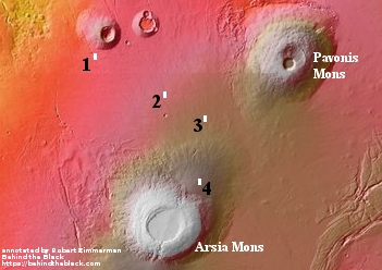
The concept is an excellent one, especially for exploring the caves and pits of Mars. This test however only checked out the lidar. A drone that could do this on either Mars or the Moon does not yet exist.
I have posted their video of the flight below the fold.
Note: Thanks to reader Eddie Willers for noting that I mistakenly located this research in Greenland, not Iceland. Post now corrected.
» Read more