The mysterious slope streaks of Mars

Massive flow on Mars
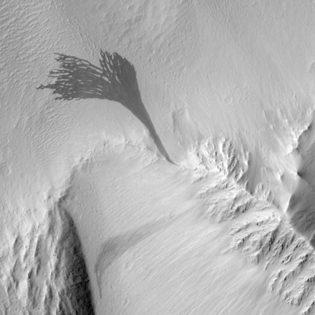
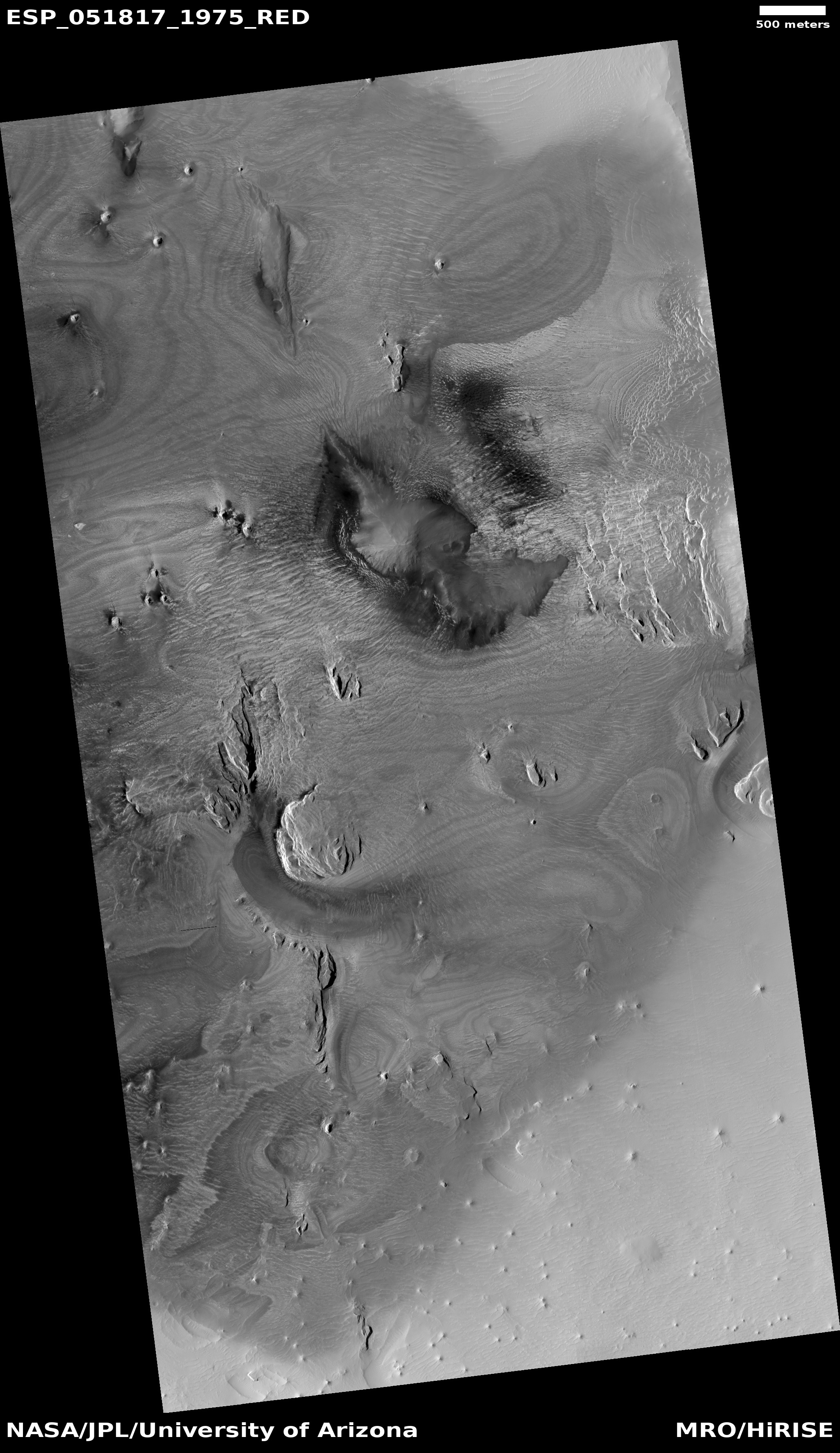
A typical Martian slope streak.

The uncertainty of science: In the past decade or so scientists have documented in detail a number of features on the Martian surface that evolve or change over time. From the constantly changing poles to the tracks of dust devils to landslides to the appearance of seasonal frost, we have learned that Mars is far from a dead world. Things are happening there, and while they are not happening as quickly or with as much energy as found on Earth, geological changes are still occurring with regular frequency, and in ways that we do not yet understand.

Of the known changing features on Mars, two are especially puzzling. These are the two types of changing streaks on the slopes of Martian cliffs, dubbed recurring slope lineae (referred as RSLs by scientists) and slope streaks.

Lineae are seasonal, first appearing during the Martian summer to grow hundreds of feet long, and then to fade away with the arrival of winter. Their seasonal nature and appearance with the coming of warm temperatures suggests that water plays a part in their initiation, either from a seep of briny water or an avalanche of dust. Or a combination of both. The data however does not entirely fit these theories, and in fact is downright contradictory. Some studies (such as this one and this one) say that the seasonal lineae are caused by water. Other studies (such as this one and this one) say little or no water is involved in their seasonal formation.

The answer remains elusive, and might only be answered, if at all, when Curiosity takes a close look at two lineae in the coming years.

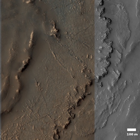
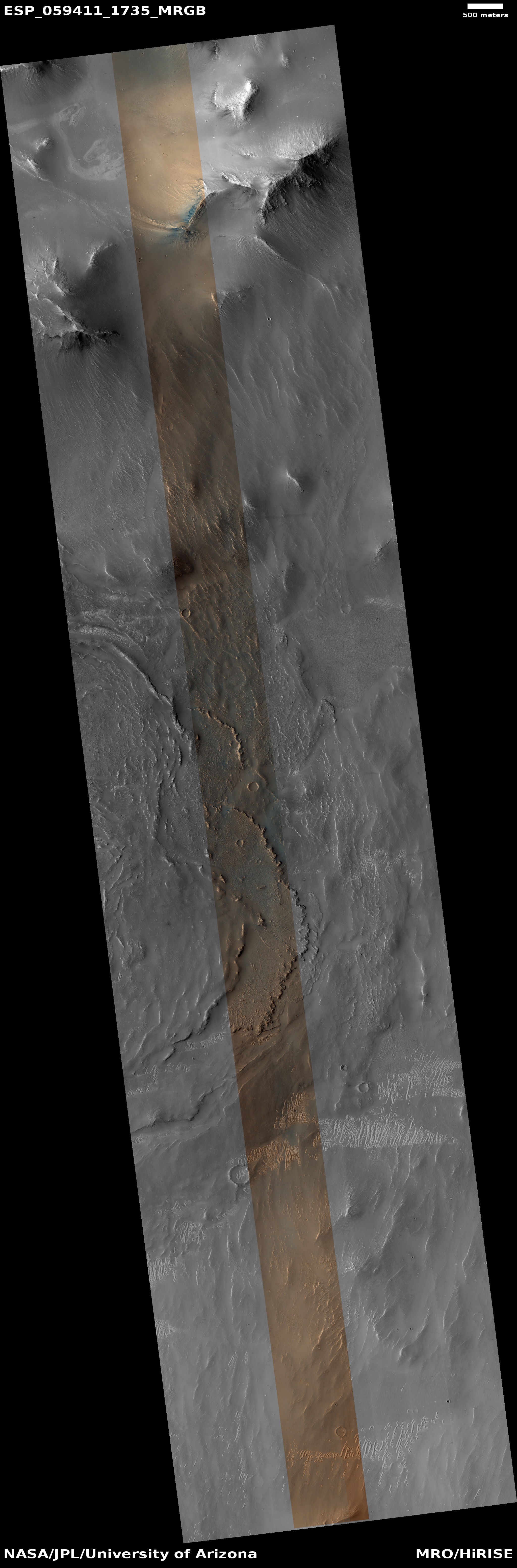
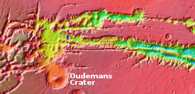
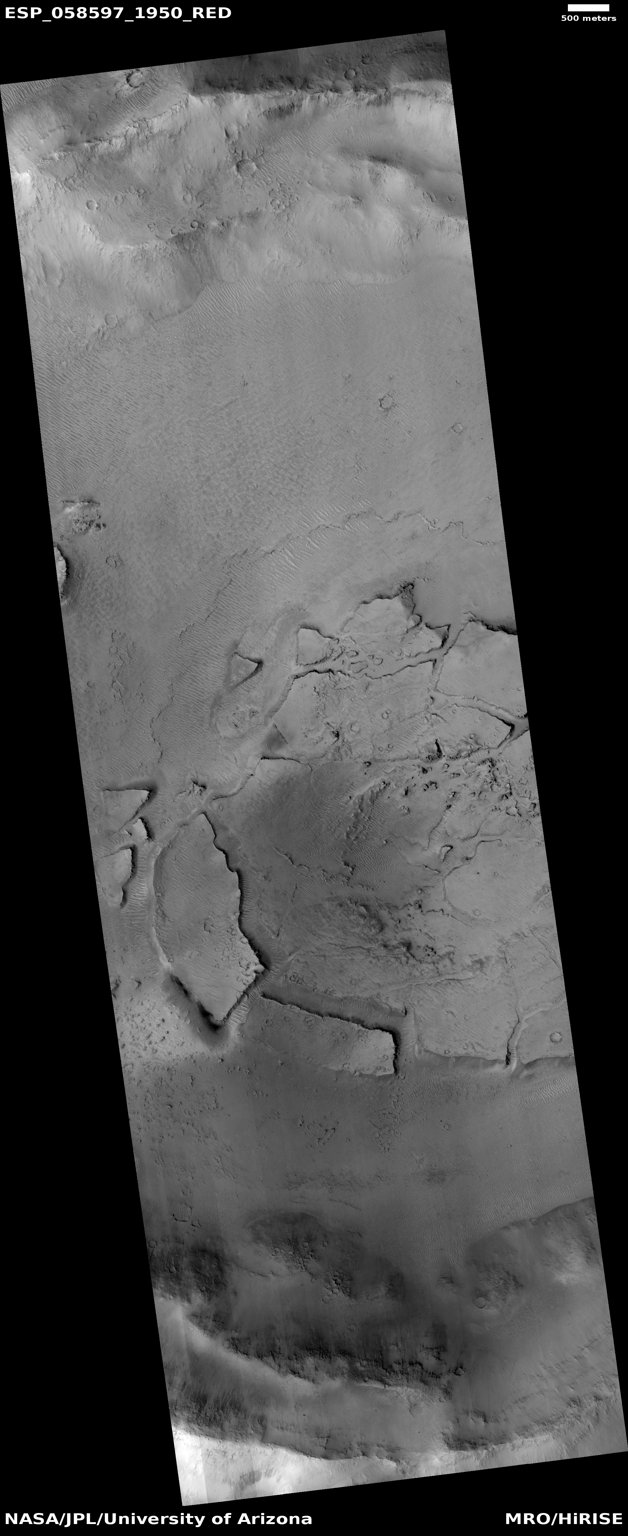
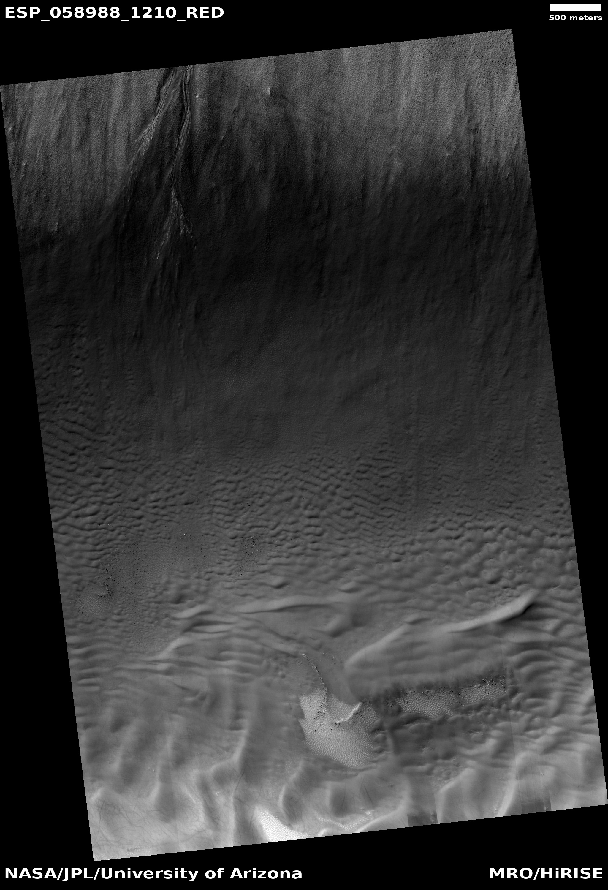
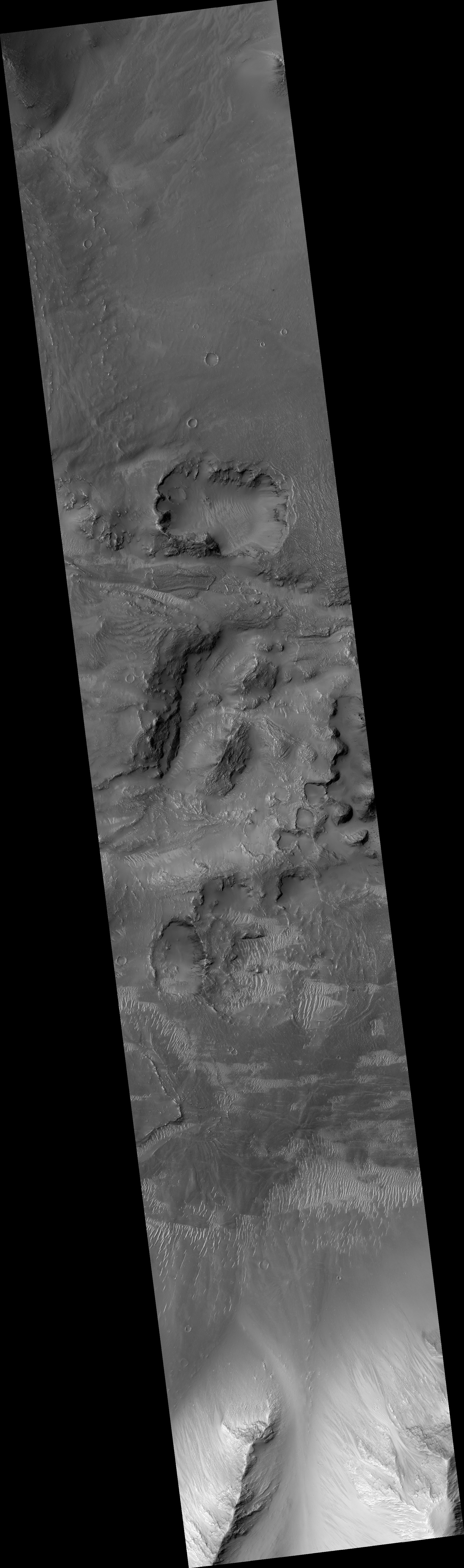
Slope streaks however are the focus of this post, as they are even more puzzling, and appear to possibly represent a phenomenon entirely unique to Mars. I became especially motivated to write about these mysterious ever newly appearing features when, in reviewing the May image release from the high resolution camera on Mars Reconnaissance Orbiter (MRO), I found four different uncaptioned images of slope streaks, all titled “Slope Stream Monitoring.” From this title it was clear that the MRO team was re-imaging each location to see if any change had occurred since an earlier image was taken. A quick look in the MRO archive found identical photographs for all four slope streak locations, taken from 2008 to 2012, and in all four cases, new streaks had appeared while older streaks had faded. You can see a side-by-side comparison of all four images below the fold.
» Read more

3 comments

The floor of Marineris Valles

Close-up of the floor of Marineris Valles

Larger view
Click for the full image.

To the right is small section cropped out of an image, taken by the high resolution camera of Mars Reconnaissance Orbiter (MRO) on March 30, 2019, of one very tiny area of the floor of the 2,500 mile long Marineris Valles, the biggest known canyon in the solar system.

Below this on the right is a larger section of the full image, with the white box showing the part covered by the top photograph. The general flow direction is to the east.

The photograph, uncaptioned, is titled “Terminus of Pitted Materials Emanating from Oudemans Crater.” Oudemans Crater is about 55 miles across and is located near the head of Marineris Valles to the east of the giant volcanic region dubbed the Tharsis Bulge. The meteorite that caused this crater is estimated to have been a little less than 3 miles in diameter. It is believed by some scientists that the impact heated up subsurface carbon dioxide permafrost which then explosively flooded down the Valles Marineris into the Northern Plains of Mars, pushing a lot of pulverized debris in front of it..

Instead of liquid water, what is stored underground on Mars is liquid CO2 and when a collapse occurs, this boils almost instantly and explosively to CO2 vapour, blasting the rock and regolith to dust, except for the most resistant fragments such as igneous rocks. The rest of the regolith is composed of dust and gravel, weakly cemented by water ice. On Mars, water is not a fluid, but behaves as a mineral in most situations. Grains of ice would be tumbled along in the cryogenic flows, and transported as passive solids just like quartz grains are transported as sand by rivers on Earth.

This theory, if correct, would eliminate the need for liquid water on the surface, and would explain many of the planet’s geological surface features.

Overview

The overview thumbnail to the left shows the location of both Oudemans Crater and this MRO image, indicated by the very tiny blue rectangle near the thumbnail’s center..

The “pitted materials” in the image’s title refers to that flowing avalanche of pulverized ice, rock, and dust, shown in the picture by the curved terraced cliffs descending to the east. This is where this material settled as it flowed eastward, pushed by that explosive CO2 flood.

You can see another example of this eastward flow in another MRO image taken just to the west. The canyon floor is pitted, confused, and rough, but there is an obvious flow trend to the east.

In fact, much of the floor of Marineris Valles that has been photographed at high resolution is similarly rugged. It will be a challenge to explore this place, especially because we have only imaged a small percentage at high resolution. There is much there that remains unseen and unknown.

0 comments

Fractured and collapsed Martian crater floor

Fractured and collapse Martian crater floor
Click for full image.

Time for some puzzling Martian geology. The image on the right, rotated, cropped, and reduced to post here, comes from the Mars Reconnaissance Orbiter (MRO) high resolution archive, and shows a strangely collapsed and fractured crater floor. In fact, like a number of other Martian craters, rather than having a central peak, the center of the crater floor, shown at the image’s center right, seems depressed.

The crater is located in a region dubbed the Cerberus Plains, in a hilly subregion called Tartarus Colles. Of the transition zone between the northern lowlands and the southern highlands these plains comprise the second largest region.

Being in the transition zone I would guess that the geology here is strongly influenced by the ebb and flow of the slowly retreating intermittent ocean that is thought to have once existed in the nearby lowlands. As water came and went, it created a variety of shoreline features scattered about, but not in a single sharp line as we would expect on Earth. Think more like tidal pools, where in some areas water gets trapped and left behind only to sublimate away at at later time.

We can see some hints of these processes in the images of the floors of two other craters that I have previously highlighted, here and here.

With this geological overview in mind, the broken plates here remind me of features I’ve seen in caves. Mud gets washed into a passage, partly filling it. Over time a gentle water flow over the surface of the mud deposits a crust of calcite flowstone on top of the mud. Should the water flow suddenly increase, it will wash out the mud below the crust. If the crust is not very strong or thick, it will crack into pieces as it falls, and thus resemble what we see here in this Martian crater.

There are cases where the crust becomes thick enough to remain standing, which produces some spectacular hanging calcite draperies that seem to defy explanation.

The collapse in the center of the crater is more puzzling, but suggests, based on comparable-looking Earth geology, that any perched water in this canyon might have actually drained out through underground drainage, accessed through the depression.

Be warned: All my explanations above are based on what exists on Earth, and Mars is very different from Earth. The lower gravity, colder temperatures, and different chemistry guarantee that the geological processes there will not be identical. We start by using what we know here, but recognize that we need to learn more about Mars to truly understand what goes on there.

1 comment

The temperature on Phobos

The temperature on Phobos
Click for full image.

The Mars Odyssey science team today released false color images of the Martian Moon Phobos showing the temperature range that the spacecraft has detected, shown above in a reduced form.

The April 24, 2019 image is the first time Mars Odyssey had gotten a full moon look at the Moon. Not surprisingly, the hottest spots on the surface are at the center, at noon, with it getting cooler as one gets to the outer edges near dawn and dusk and at the poles.

0 comments

The many pits of Arsia Mons

The many pits of Arsia Mons

When it comes to Mars, it appears that if you want to find a pit that might be the entrance to an underground system, the place to look is on the slopes of Arsia Mons, the southernmost volcano in the chain of three giant volcanoes between Olympus Mons to the west and the vast canyon Marineris Valles to the east.

To the right is an overview map showing the pits that have been imaged since November by the high resolution camera of Mars Reconnaissance Orbiter (MRO). The black squares show the pits that I highlighted in previous posts on November 12, 2018, February 22, 2019, and April 2, 2019. The numbered white squares are the new pits found in March photograph release from MRO.

And this is only a tiny sampling. Scientists have identified more than a hundred such pits in this region. Dubbed atypical pit craters by scientists, they “generally have sharp and distinct rims, vertical or overhanging walls that extend down to their floors, surface diameters of ~50โ€“350โ€‰m, and high depth to diameter (d/D) ratios” that are much greater than impact craters, facts that all suggest that these are skylights into more extensive lava tubes.

Below are the images of today’s four new pits.
» Read more

1 comment

Curiosity second drill hole in clay formation a success

two drill holes in clay formation
Click for full image.

The Curiosity science team has confirmed that their second drill hole in the clay formation that the rover is presently exploring was a success.

They have confirmed that enough material from the drill hole has been deposited in their chemical analysis hopper.

The image to the right, cropped and reduced to post here, shows both drill holes on the two different flat sections of bedrock near the top.

It seems that the science team wants to spend a lot of time in this location, as described in my last rover update. It is therefore unclear when they will move south to follow their long term travel plans.

2 comments

Another spectacular landslide found on Mars

Landslide in Hydraotes Chaos
Click for full image.

Cool image time! In perusing the April image release from the high resolution camera of Mars Reconnaissance Orbiter (MRO), I came across the image above, cropped and reduced to post here, of the discovery of another landslide within Hydraotes Chaos, one of the largest regions of chaos terrain on Mars. The image above was taken on February 9, 2019, and has since been followed up with a second image to create a stereo pair.

This is not the first landslide found in Hydraotes Chaos. I highlighted a similar slide on March 11. Both today’s landslide as well as the previous one likely represent examples of gravitational collapses as shown in this science paper about Martian ground water. Some scientists have proposed that Hydraotes Chaos was once an inland sea, and as the water drained away the loss of its buoyancy is thought to cause this kind of landslide at the base of cliffs and crater rims.

The past presence of water also helps explain the soft muddy look of this landslide. When this collapse occurred the material was likely saturated with water. Today it is most likely quite dry and hardened, but when it flowed it flowed like wet mud. Its size, almost a mile long and a quarter mile across, speaks to Mars’s low gravity, which would allow for large singular collapses like this.

Hydraotes Chaos itself is probably one of the more spectacular places on Mars. It sits at the outlet to Marineris Valles, shown in the image below. This gigantic canyon, which would easily cover the entire U.S. if placed on Earth, was the largest drainage from the large volcanic Tharsis Bulge to the west, where Mars’s largest volcanoes are located.
» Read more

0 comments

First Marsquake recorded by InSight?

The InSight science team has announced that they think they have detected their first Mars quake, though it was too small to provide much information about the Martian interior.

The Martian surface is extremely quiet, allowing SEIS, InSightโ€™s specially designed seismometer, to pick up faint rumbles. In contrast, Earthโ€™s surface is quivering constantly from seismic noise created by oceans and weather. An event of this size in Southern California would be lost among dozens of tiny crackles that occur every day.

โ€œThe Martian Sol 128 event is exciting because its size and longer duration fit the profile of moonquakes detected on the lunar surface during the Apollo missions,โ€ said Lori Glaze, Planetary Science Division director at NASA Headquarters.

…Three other seismic signals occurred on March 14 (Sol 105), April 10 (Sol 132) and April 11 (Sol 133). Detected by SEISโ€™ more sensitive Very Broad Band sensors, these signals were even smaller than the Sol 128 event and more ambiguous in origin. The team will continue to study these events to try to determine their cause.

The data so far suggests is that Mars is far quieter than Earth geologically, but any conclusions at this point would be premature.

0 comments

UAE’s space agency declares its Mars probe almost ready for launch

The new colonial movement: The space agency of the United Arab Emirates (UAE) today announced that its 2020 Mars orbiter, dubbed Hope, is now 85% complete and on track for making its launch window.

The Probe has already entered an intensive testing phase to ensure its readiness before the launch date, with less than 500 days are remaining for the launch. It is planned to reach Mars by 2021, coinciding with the 50th anniversary of the founding of the UAE.

Several aspects related to the design, assembly of the structure, cameras and control have been verified. So far, the Probeโ€™s systems and components, as well as its ability to communicate with the ground station have been checked by the team. The Probe has succeeded in all the tests it has been subject to so far, ahead of the five environmental tests to be conducted on the probe from June to December 2019.

While this is likely true, we must remain a bit skeptical. Though the link goes to a Reuters Arab news source, the story appears to be entirely a copy of the press release. I know this because five different Arabian news sources used the exact same language in their stories, apparently all copying from the same release.

Thus, we don’t have any independent press in the UAE looking at what is going on here. This could be true, but who knows?

0 comments

How last year’s global dust storm changed one spot on Mars

One spot on the western flank of  Olympus Mons, August 2017
Click for full image.

To the right is an image taken by the high resolution camera on Mars Reconnaissance Orbiter (MRO) back in August 2017, cropped, rotated, and reduced to post here. It shows a particular spot on the western slope of the giant volcano Olympus Mons. The uncaptioned image release is entitled “Dark and Possibly Stationary Ripples in Anomalous Terrain.” The image was probably taken as a follow-up to this 2009 image to see if the the dark patches near the peaks and mounds as well as the strange wavy bands of light and dark had changed in eight years. As of 2017 however little had changed. The patches in the 2009 image seem darker, but that is almost certainly due to the lower sun angle causing longer shadows.

The slope goes downhill to the left. The wavy bands are thought to be geological layers exposed by erosion. The cause of the dark patches remain unknown.

I stumbled upon these two early images because of a third new image of this location, taken in February 2019 and spotted by me during my review of April 2019 images downloaded from MRO. That uncaptioned new image was titled “Change Detection in Olympus Maculae.” Had scientists spotted some new volcanic activity at this spot? To find out I dug into the MRO archive at this location and found both the 2009 and 2017 images.

The 2019 image is below. It is cropped, rotated, and reduced to match exactly with the image above in order to highlight any changes that might have occurred.
» Read more

1 comment

Seasonal frost in a gully on Mars

Frost in a gully on Mars
Click for full image.

Cool image time! The photo on the right, cropped, reduced, and brightened slightly to post here, was part of the April image release from the high resolution camera on Mars Reconnaissance Orbiter (MRO). According to the titled of this release, it purports to show visible frost on what looks like an avalanche debris slope on the rim of a large crater. The frost is the bright streaks on the upper left of the slope.

I wonder. During last month’s 50th Lunar and Planetary Science Conference in Texas, there was one paper that I reported on that showed something very similar to this, and proposed that white streaks like this in a gully were actually exposed snow/ice. They proposed that the snow/ice was normally covered by dust, and the white streaks were where the dust had blown away to reveal the ice below. This in turn would then sublimate into gas, which in turn would cause the gully avalanches over time.

Below is a close-up of the white streaks on this rim.
» Read more

1 comment

Rover update: April 11, 2019

Summary: Curiosity successfully drills into the clay unit. Yutu-2 continues its exploration on the far side of the Moon.

For the updates in 2018 go here. For a full list of updates before February 8, 2018, go here.

Curiosity drill hole in clay unit on slopes of Mount Sharp

Curiosity

For the overall context of Curiosity’s travels, see my March 2016 post, Pinpointing Curiosityโ€™s location in Gale Crater.

The news this week from Curiosity is that the rover has successfully drilled into the ground in the clay unit valley the rover is presently exploring betweent Vera Rubin Ridge and Mount Sharp’s higher slopes.

The image to the right shows is a close-up of that drill hole.

The rover’s drill chewed easily through the rock, unlike some of the tougher targets it faced nearby on Vera Rubin Ridge. It was so soft, in fact, that the drill didn’t need to use its percussive technique, which is helpful for snagging samples from harder rock. This was the mission’s first sample obtained using only rotation of the drill bit.

Since my last rover update on February 20, 2019, they have been traveling for several weeks to get to a spot where they can do this drilling. The clay unit seems very soft, and almost mudlike, which made finding a good surface to drill somewhat challenging. Most of the terrain seemed too soft to drill into. It almost would be better to have a scoop, as the Viking landers had. Curiosity doesn’t really have this however. It needs to use its drill, which really is a more efficient way to get down deeper into the ground anyway.

The map below shows their recent travels.
» Read more

0 comments
1 138 139 140 141 142 212