Mars Reconnaissance Orbiter image of Curiosity

Curiosity as seen from orbit

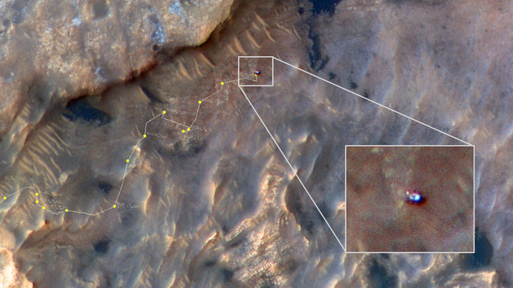
The Mars Reconnaissance Orbiter (MRO) science team today released an image taken on May 31, 2019 by the orbiter’s HiRISE high resolution camera of Curiosity when it was nestled against the cliff at the bottom of Vera Rubin Ridge.

The image above is that enhanced color image, reduced and annotated to post here. I have added the track of Curiosity’s route down from Vera Rubin Ridge leading up to the point where this picture was snapped.

In the image, Curiosity appears as a bluish speck. Vera Rubin Ridge cuts across the scene north of the rover, while a dark patch of sand lies to the northeast.

Look carefully at the inset image, and you can make out what it is likely Curiosity’s “head,” technically known as the remote sensing mast. A bright spot appears in the upper-left corner of the rover. At the time this image was acquired, the rover was facing 65 degrees counterclockwise from north, which would put the mast in about the right location to produce this bright spot.

Mirror-like reflections off smooth surfaces show up as especially bright spots in HiRISE images. For the camera to see these reflections on the rover, the Sun and MRO need to be in just the right locations. This enhanced-color image of Curiosity shows three or four distinct bright spots that are likely such reflections.

From this location Curiosity first continued along the cliff’s base to study that dark patch of sand to the northeast, then it turned almost due south in order to get back to its nominal route into Gediz Valles canyon, as shown in my May 30, 2019 rover update.

0 comments

Wheel update on Curiosity

Periodically, the Curiosity science team stops from its research to reassess the condition of the rover’s wheels. To do this they use the rover’s color camera, dubbed the Mast Camera (Mastcam), taking close-up pictures of the wheels to compare those with earlier photographs see if there has been any additional damage and deterioration over time.

Yesterday Mastcam took a new series of images of the rover’s wheels. Below are two pictures, the left taken on August 27, 2017, the right taken on July 7, 2019. I have annotated the images to help indicate where they match.
» Read more

0 comments

ExoMars 2020 parachutes damaged during test

Bad news: The parachutes for the European/Russian ExoMars 2020 mission were damaged during a parachute test.

A May 28 test of the parachute system used a high-altitude balloon above the Swedish Space Corporation’s Esrange test site in northern Sweden. The test was intended to demonstrate the end-to-end performance of the entire system, including both the pilot and main chutes as well as the mortars used to extract the pilot chutes.

ESA said that the first main parachute suffered several radial tears in its fabric, all occurring before reaching its maximum load. The second main parachute also suffered a single tear, also before peak loading.

The other parts of the parachute system worked as expected, and ESA said “a good level of the expected aerodynamic drag was nevertheless achieved” despite the damage sustained by the parachutes. However, the agency acknowledged that the problem needs to be understood and corrected prior to the mission’s launch in one year.

They can easily get the parachutes repaired before the July 2020 launch. The problem is figuring out what caused the damage and fixing that in the time left. They already had planned two more parachute tests, but these cannot happen prior to all the fixes, and then they have to work.

Considering that they will only assemble the spacecraft at the end of this year, I am increasingly thinking that ExoMars 2020 will not launch in 2020. And if it does, I will not be surprised if it turns out to be a failure.

2 comments

The Martian seabed?

Cones and strange blobs
Click for full image.

Cool image time! Above is an image taken by the high resolution camera of Mars Reconnaissance Orbiter (MRO) in November 2018 of an area in the vast relatively featureless northern lowlands of Mars. I have rotated, cropped, and reduced it to post here.

I have also indicated two sections, indicated by the white boxes, that I have cropped out of the full resolution image to highlight some interesting features. Both images can be seen in full resolution below.

While the northern lowlands seem featureless from a distance, with few craters, a closer look always reveals many things that are both baffling and fascinating. In this case the region is called Galaxias Colles, a region of mesas and knobby hills. This particular image was dubbed “Cones in Galaxias Colles,” and was clearly taken to get a better look at these strange blobby features.
» Read more

0 comments

Where are the caves on Mars?

Overview map of pits near Arsia Mons

Each month I go through the monthly download of new images from the high resolution camera on Mars Reconnaissance Orbiter (MRO). And each month since November I have found a bunch of newly discovered pits photographed in the region around the volcano Arsia Mons (see: November 12, 2018, January 30, 2019, February 22, 2019, April 2, 2019, and May 7, 2019). The map on the right has been updated to include all those previous pits, indicated by the black boxes, with the new pits from June shown by the numbered white boxes.

To the right are the first three pits in the June archive, with the link to each image site found here (#1), here (#2), and here (#3).

Pits 1 through 3
For full images: Number 1, Number 2, Number 3.

All three are what the scientists doing this research call Atypical Pit Craters:

These Atypical Pit Craters (APCs) generally have sharp and distinct rims, vertical or overhanging walls that extend down to their floors, surface diameters of ~50–350 m, and high depth to diameter (d/D) ratios that are usually greater than 0.3 (which is an upper range value for impacts and bowl-shaped pit craters) and can exceed values of 1.8. Observations by the Mars Odyssey Thermal Emission Imaging System (THEMIS) show that APC floor temperatures are warmer at night and fluctuate with much lower diurnal amplitudes than nearby surfaces or adjacent bowl-shaped pit craters.

The fourth pit, shown in the reduced and cropped image below, might actually be the most interesting of the June lot.
» Read more

3 comments

Insight engineers get first look at hole

InSight Mole hole
Click for full image.

The Insight engineering team has successfully lifted the mole structure allowing them to see the hole the mole was pounding into the Martian ground in their effort to diagnose why the mole has been unable to drill more than a foot or so down.

The image to the right shows the mole, the white tubelike structure, inside the hole. As noted by Instrument Lead Tilman Spohn,

I along with others from the team were a bit shocked when we saw how large the pit actually is. Its diameter is about two times the diameter of the mole. The bottom of the pit is difficult to see (we expect better images once the lift is complete) but it seems that it is about 2-2.5 mole diameters deep. A mole diameter is 27mm. So the mole must have compacted the regolith quite a bit. In addition to its own volume it must have displaced about half of its buried volume.

There seems to be a little rim surrounding the pit but most of the displacement likely was compaction. We cannot see the inclination of the wall very well but it at least seems to me that the mole was “precessing” (like a spinning top) and carved a conical hole. This is consistent with the recordings of our tiltmeter STATIL during the hammering in March. We will have to wait for better images to confirm or disprove that. In any case, the apparent compaction seems to be compatible with a large porosity, relatively low density.

What they do next is unknown. From what I understand, they do not have the option of lifting the mole out and trying a different location. Moreover, the images and data suggest it wouldn’t matter anyway. The mole is apparently not designed to drill a shaft in this kind of ground.

3 comments

Chaos on Mars

Aurorae Chaos in Margaritifer Terra
Click for full image.

The Mars Express science team today released a digital perspective view of the chaos terrain located in the outlet region for the vast drainages, which include Marineris Valles, coming down from the Tharsis Bulge volcanic region that holds Mars’ largest volcanos.

The view, reduced to post here on the right, was created from a image taken by Mars Express on October 31, 2018. This chaos terrain is south of the various examples of chaos terrain previously highlighted here on Behind the Black (May 14, 2018, June 26, 2018, March 11, 2019, March 14, 2019). As they note,

The division between the chaotic terrain and plains can also be seen clearly in these images. The left (south) side of the image is notably smoother and more featureless than the jumbled right (north) side, and the two regions are split by a prominent line carving diagonally across the frame. The transition area around this scarp is especially broken and fractured; this is thought to be caused as the martian crust stretched and moved.


The ancient chaotic terrain we see on Mars holds information about how water once permeated and interacted with the planetary surface, including how it was transported, stored, and released.

Chaotic terrain is thought to have formed as chunks of the martian surface collapsed in dramatic events triggered by the heating of material containing ice or water-bearing minerals – possibly due to climatic or volcanic heat sources, or an impact from an asteroid or comet. This released large amounts of water, causing the terrain above to subside. The water then drained away quickly, leaving behind the messy, broken patterns seen in regions such as Aurorae Chaos, which is thought to have formed some 3.5 billion years ago.

Mars Express images don’t quite have the resolution of the high resolution images from Mars Reconnaissance Orbiter, but they cover a wider area, so that the spacecraft has now photographed almost the entire Martian surface since its arrival in Mars orbit in December 2003.

0 comments

The expanding range for Martian ice scarps

Another ice scarp
Click for full image.
/p>

The discovery in January 2018 of a number of Martian cliff faces, or scarps as the scientists dubbed them, with a visible and apparently very accessible underground layer of ice, had significant ramifications.

First, it proved that, in at least one area south of Hellas Basin and one spot in the northern hemisphere, an underground ice table existed on Mars at latitudes as far south as 55 degrees. Scientists had theorized that this ice table, comparable to the water table on Earth, existed, but here was visible proof.

Second, the discovery showed places where water could be accessed relatively easily by future colonists. There are plenty of indications from orbiter images and lander/rover data that water is present in many places on Mars, but here the water appeared almost pure and could be obtained without major digging or processing. Whether that ice table extends even farther south, making it even more accessible, remains as yet a scientific question.

In the next few months the scientists involved in this research located more ice scarps in areas beyond the range of those initial discoveries. Since then however even more scarps have been found, including the scarp in the image above and to the right, cropped, reduced, and annotated to post here.

This particular scarp is located inside a crater. The uncaptioned release from the high resolution camera on Mars Reconnaissance Orbiter (MRO), described it as a “Scarp in mantling material.” According to Colin Dundas of the U.S. Geological Survey’s Astrogeology Science Center in Arizona,
» Read more

1 comment

Another odd crater on Mars

Odd shaped crater
Click for full image.

Cool image time! In a sense, to announce that scientists have found an oddly shaped crater on Mars is to state the obvious. In the years since the first Martian fly-by by Mariner 4 in 1965, scientists have been discovering numerous odd-shaped craters on Mars, every single of which has challenged our assumptions about the planet’s geology. I myself have posted a half dozen such posts since January (January 7, January 10, January 14, March 26, March 27, June 12).

Yet, it is always worth looking when another one crops up, because of the fact that they challenge our assumptions about Martian geology. They are also always cool to look at! On the right, cropped and reduced to post here, is an image taken by the high resolution camera on Mars Reconnaissance Orbiter (MRO) on April 19, 2019 of what the scientists have dubbed an “Odd Shaped Crater in Arabia Terra.”

Overview map

Arabia Terra is one of the largest regions of the transition zone between the northern lowlands and the southern highlands. This crater is located, as shown by the red cross in the overview map to the right, near its northern edge, in an area where the descent into the northern lowlands is somewhat abrupt and broken up by large craters and chaos terrain.

The crater itself holds numerous geological mysteries. Its shape suggests two impacts of different sizes overlapping each other, but without any remnant of the inner rim of the second impact. Where did that remnant go? Or maybe this wasn’t caused by two impacts, but by one impact that reshaped the surface in this odd and inexplicable way.

Then there is the three teardrop-shaped patterns in the crater’s floor. They look like the brushstrokes of a giant-sized painter. Were they caused by the wind? And if so, why in this pattern?

Planetary geologists could probably come up with a dozen more questions. The number tells us how little we know about Mars.

4 comments

Elementary students to compete to name 2020 Mars rover

NASA has initiated a project to have the nation’s K-12 elementary school children compete to name the 2020 Mars rover.

NASA has selected two partner organizations to run a nationwide contest giving K-12 students in U.S. schools a chance to make history by naming the Mars 2020 rover. An application to become contest judge also is now available online.

Battelle Education, of Columbus, Ohio, and Future Engineers, of Burbank, California, will collaborate with NASA on the Mars 2020 “Name the Rover” contest, which will be open to students in the fall of 2019. The student contest is part of NASA’s efforts to engage the public in its missions to the Moon and Mars.

They are also looking for people to judge the contest.

6 comments

Exploring with Mars Reconnaissance Orbiter

Terrain sample
Click for full image.

In my never-ending rummaging through the images released each month from the high resolution camera on Mars Reconnaissance Orbiter (MRO), I have sometimes been puzzled by the titles they choose for some photographs. For example, many pictures each month are simply titled “Terrain Sample.” The image to the right, cropped and reduced to post here, is one example, and its content adds to the mystery.

The photograph itself shows a generally featureless surface. Other than the scattering of small craters, there are only very slight topographical changes, the most obvious of which is the meandering ridge to the east of the largest crater.

I wondered why this picture was taken, and why it was given such a nondescript name. To find out, I emailed Veronica Bray at the University of Arizona. She had requested this image as part of her job as a targeting specialist for MRO. Her answer:
» Read more

0 comments

Spike in methane detection in Gale Crater

The uncertainty of science: In the past week Curiosity has suddenly discovered a spike, the largest ever, in the amount of methane in the local atmosphere.

The amount detected was still quite tiny, 21 parts per billion by volume.

Curiosity doesn’t have instruments that can definitively say what the source of the methane is, or even if it’s coming from a local source within Gale Crater or elsewhere on the planet.

“With our current measurements, we have no way of telling if the methane source is biology or geology, or even ancient or modern,” said SAM Principal Investigator Paul Mahaffy of NASA’s Goddard Spaceflight Center in Greenbelt, Maryland.

While there is going to be a lot of speculation in the press and among scientists who should know better, this detection remains a major mystery. We as yet have no idea what caused it. Nor is it likely to have been caused by biology, though that does remain a possibility.

What is most puzzling is that the terrain that Curiosity is presently traveling across, the clay unit at the foot of Mount Sharp, shows no likely source.

This past weekend the scientists focused the rover’s instruments on this topic, in the hope this could help narrow the problem.

0 comments
1 136 137 138 139 140 212