Click for interactive map.
This week I have returned several times to the giant Valles Marineris canyon on Mars in an attempt to capture its incomprehensible and glorious scale. Without question this canyon is going to become one of the prime tourist spots when humans begin living and working throughout the solar system. Fortunately, its vast size will mean that it will take many many centuries before it even becomes close to crowded there.
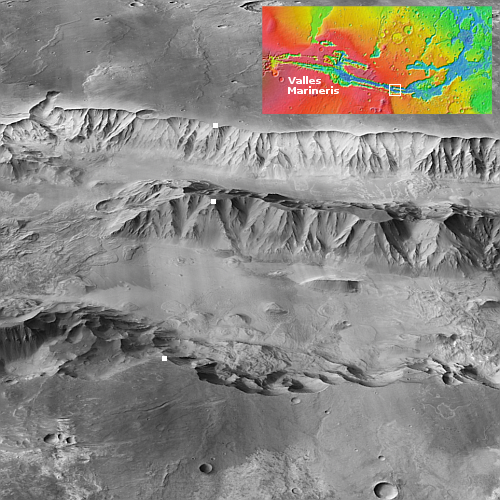
Today I try a different approach, using the global mosaic created by scientists at Caltech from the context camera images taken by Mar Reconnaissance Orbiter (MRO). That mosaic processes the images to allow one to see the surface from an oblique angle. The picture to the right covers one small part of the eastern end of Valles Marineris (the white rectangle in the inset), but though small the scale once again is gigantic.
The three white dots are our reference points, one on the north rim, one on the south, and one in the middle on the peak of that central mountain chain. Beginning from the south, the distance from the rim to the middle mountain peak is 43 miles, with the elevation dropping almost 13,000 feet to the floor of the south canyon, than rising almost 10,000 feet to the middle peak. The northern canyon is smaller. From the peak to the north rim is 27 miles, dropping about 9,300 feet and then rising about 8,500 feet to the north rim.
From rim to rim the distance is about 70 miles. Since the middle mountain chain about 18 miles wide, it fills only about 25% of the entire canyon.
In every case, the Grand Canyon would be merely be a small side canyon here. The depths are twice as deep, and the distances are many times larger. In width alone at this point Valles Marineris is seven times wider than the widest part of the Grand Canyon, and this is by far not Valles Marineris’s widest point.
» Read more


