Mountains, Mesas, and Box Canyons on the floor of Valles Marineris

Mountains, Mesas, and Box Canyons
Click for full image.

Overview map

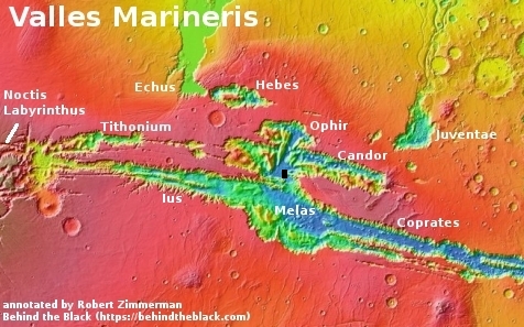
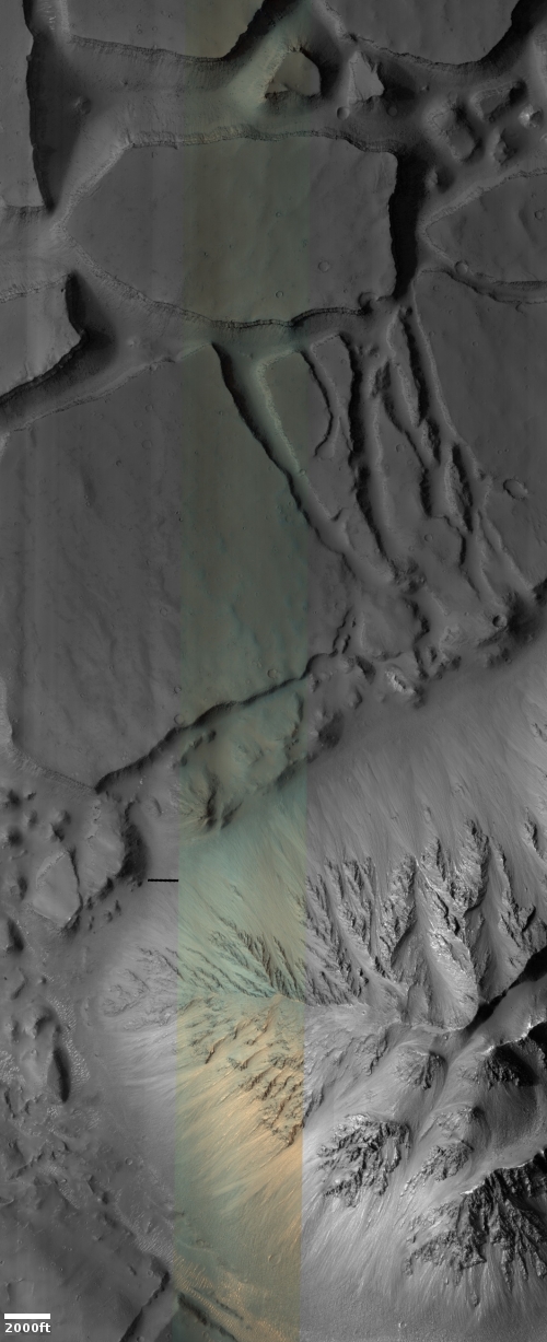
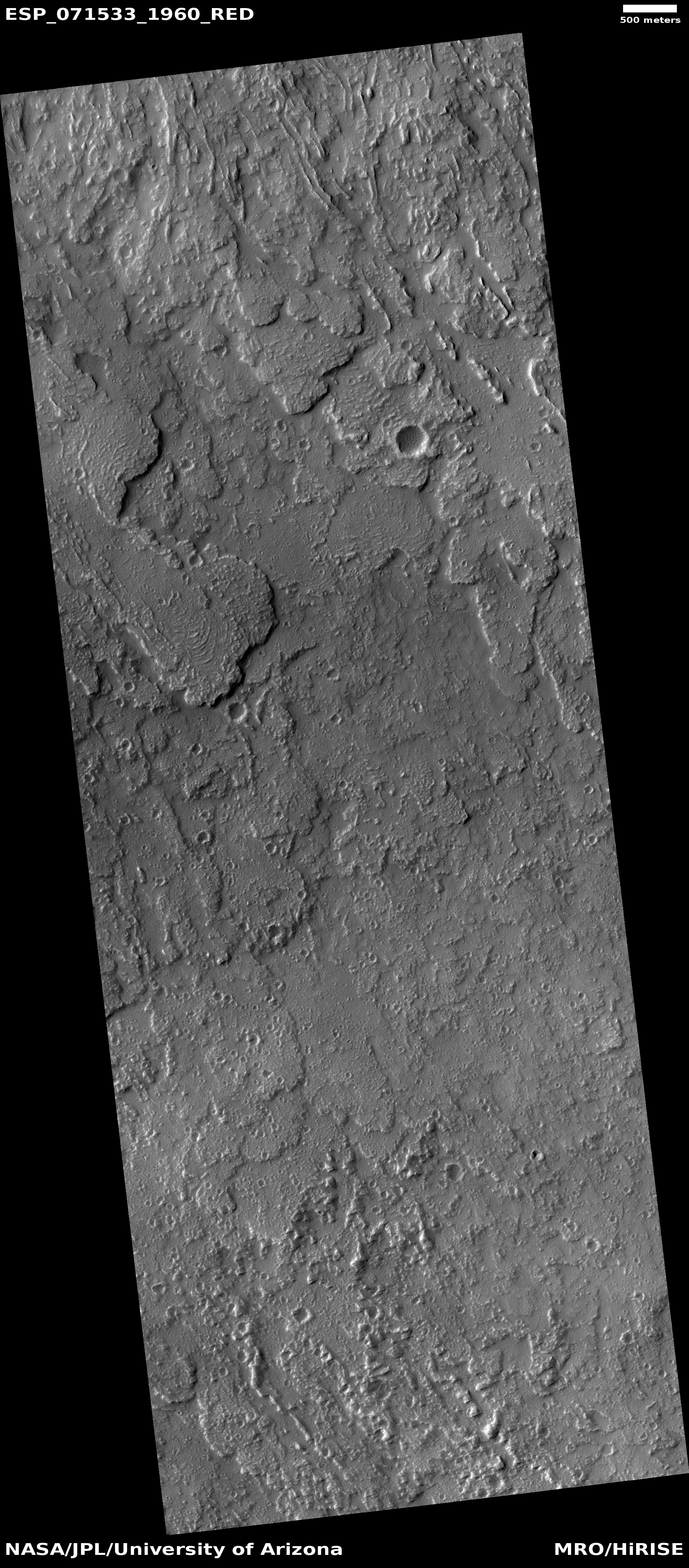
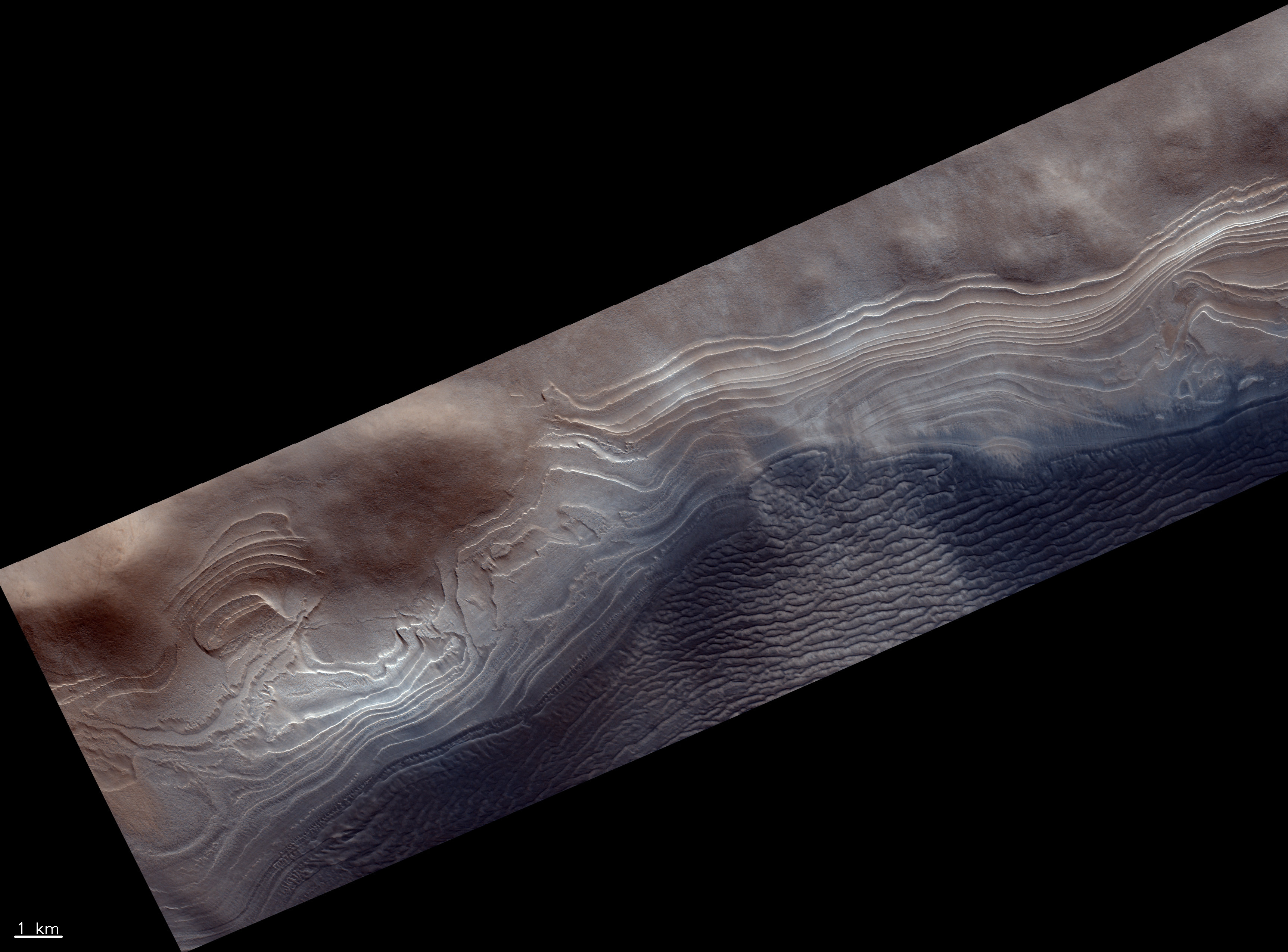
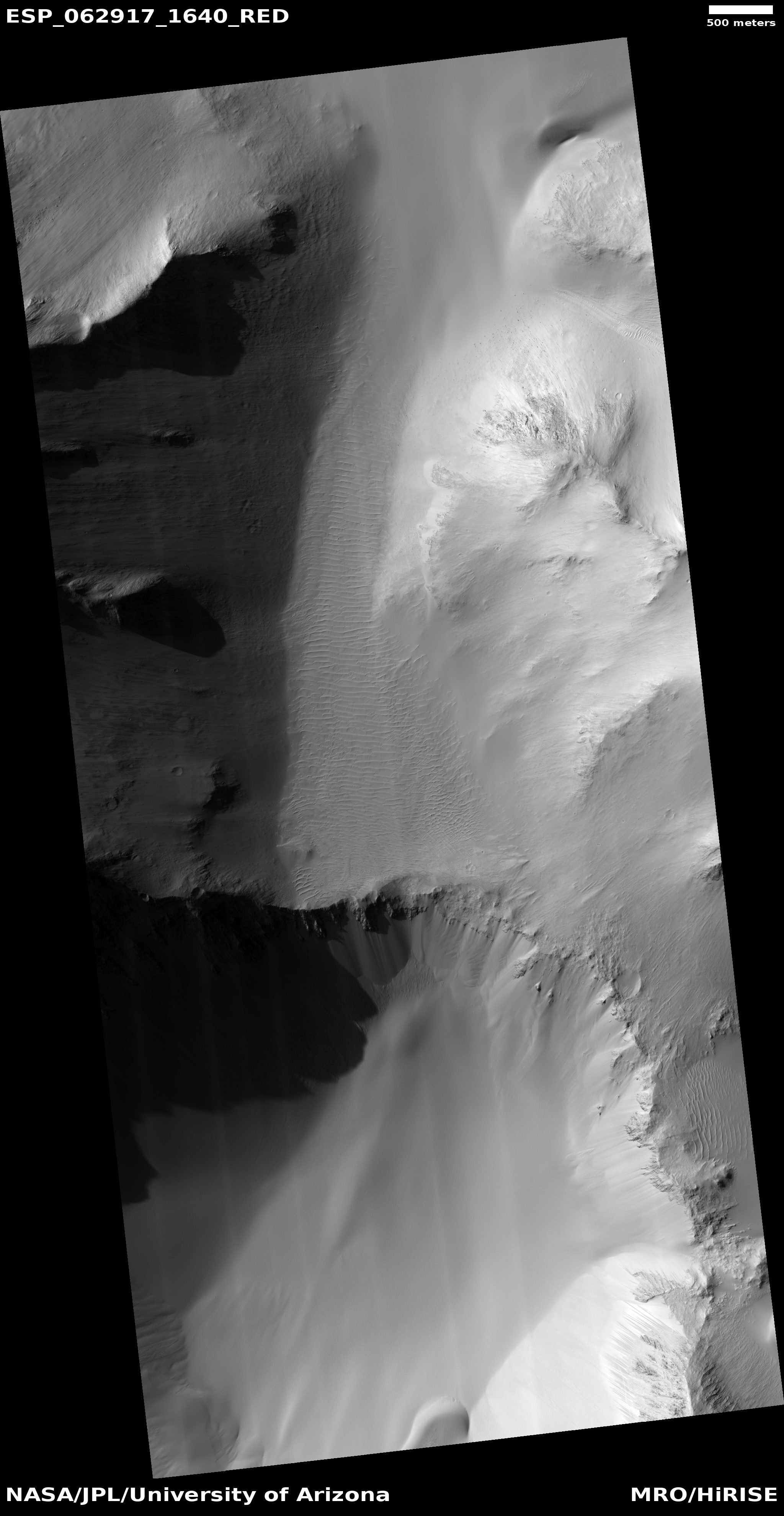
Cool image time! The photo above, cropped, reduced, and rotated to post here, was taken on March 12, 2022 by the high resolution camera on Mars Reconnaissance Orbiter (MRO). It shows a small section of the floor of the giant 2,550-mile-long and 400-mile-wide Valles Marineris canyon on Mars. In fact, this section, as indicated by the black rectangle in the overview map below, is practically in the center of the canyon, at its widest point.

The geology here hints at several Martian processes. The mesas and closed canyons in the north are typical of chaos terrain, where it erosion appears to form along fault lines to create the random intersecting canyons. In other places on Mars, in the mid-latitudes, that erosion appears mostly formed by glacial activity. Here, in Valles Marineris at only 7 degrees north latitude, little ice had been expected.

However, this spot is also in the dead center of a region where orbital data from Europe’s Trace Gas Orbiter (TGO) suggests there is a surprisingly large underground reservoir of hydrogen, which is assumed could only exist if it was locked in water molecules.

In fact, at this spot the data suggests up to 40% of the near-surface material might be composed of water (by weight). If so, that underground reservoir of ice could be causing the erosion that is creating this massive chaos terrain.

Meanwhile, the light-colored mountain in the south is the westernmost nose of a 50-mile-long ridgeline coming down from the canyon’s rim, about 30,000 feet higher. Its dendritic nature, like the hollows that form in the mountains of wet regions on Earth, suggest rainfall and water flowing downhill, wearing away these hollows over eons.

Rain however is almost certainly not the cause. Instead, we could be seeing erosion from wind, or maybe dry ice snow that fell long ago when this region was at a higher latitude when Mars’ rotational tilt was different.

Either way, the massive geology here illustrates the monumental nature of this largest canyon in the solar system, as well as the difficulties of exploring it.

1 comment

Scientists propose new theory to explain mysterious slope streaks on Mars

Slope streaks on Mars
Click for full image.

In a paper published earlier this month, scientists have proposed a new theory to explain the the origin of slope streaks on Mars, a unique Martian geological feature that at first glance look like a stainlike avalanches which also appear to do nothing to change the surface topography. (See earlier posts here and here for a description of this strange Martian phenomenon.)

Essentially, data from the orbiters suggests that carbon dioxide frost develops just under the surface during the night. In equatorial regions this frost mixes with dust (allowing it to exist even in these warmer climates). When the morning light hits the frost it causes it to sublimate away, which in turn causes the appearance of slope streaks as the dust is released from the frost.

From the paper’s abstract:

At sunrise, sublimation-driven winds within the regolith are occasionally strong enough to displace individual dust grains, initiating and sustaining dust avalanches on steep slopes, forming ground features known as slope streaks. This model suggests that the CO2 frost cycle is an active geomorphological agent at all latitudes and not just at high or polar latitudes, and possibly a key factor maintaining mobile dust reservoirs at the surface.

The cool image above, cropped and reduced to post here, was taken on October 28, 2020 by the high resolution camera on Mars Reconnaissance Orbiter (MRO) and shows an excellent example of two very spectacular large slope streaks, one long and narrow and another short and wide. Located at 23 degrees, this is an area where no ice has yet been found near the surface.

This new theory joins two other popular theories attempting to explain slope streaks. The others postulate that the streaks are either dust avalanches of a different type or the percolation of a brine of chloride and/or perchlorate in a thin layer several inches thick close to the surface.

None have been proven. None likely fit all the known data at this point.

2 comments

Why a big Earth mountain would hardly be noticed on Mars

A big mountain lost on Mars
Click for full image.

Cool image time! The photo to the right, cropped and reduced to post here, was taken on February 13, 2022 by the high resolution camera on Mars Reconnaissance Orbiter (MRO). It shows a cliff escarpment that, based on a rough estimate of MRO’s elevation data, ranges from 10,000 to 13,000 feet high. Because the sun is only about 32 degrees above the western horizon, the shadows are long and distinct and bring out the features quite dramatically.

On Earth, a mountain 13,000 feet high would generally be named, because there are really not that many of them. If it was a cliff face dropping down into a canyon, which this Martian cliff is, it would be quite unique and probably be one of the most popular tourist spots on the globe. For comparison, the rim of the Grand Canyon in the national park, visited by millions, is only 4,000 to 6000 feet in elevation. This cliff on Mars is more than twice as deep, and yet, it is hardly the most spectacular canyon rim on the red planet.

The overview map below explains this.
» Read more

2 comments

Brain terrain in Mars’ glacier country

Brain terrain in glacier country
Click for full image.

Cool image time! The photo to the right, cropped and reduced to post here, was taken on February 10, 2022 by the high resolution camera on Mars Reconnaissance Orbiter (MRO).

It shows what planetary scientists have dubbed “brain terrain”, a truly unique Martian geological feature that is not found on Earth and also remains as yet unexplained. Specifically, the brain terrain is the speckled areas between the larger flow features, all of which are probably ice or glacier related.

What especially drew me to this MRO image however was the particular flow feature in the center left that looks like either a giant squid or something out of Lovecraft horror short story. Talk about a cool image!

The downward grade here is likely to the north, as this spot is inside a north-south canyon, cutting into the southern cratered highlands. The general north-south trend of the depression here reinforce this supposition.

The overview image below provides context.
» Read more

0 comments

The icy Reull Valley of Mars

Eroded ice in crater near Reull Valles
Click for full image.

Cool image time! The photo to the right, cropped and reduced to post here, was taken on February 20, 2022 by the high resolution camera on Mars Reconnaissance Orbiter (MRO). It shows the eroded floor of a 10-mile-wide very obscured unnamed crater that sits above the northern wall of a canyon dubbed Reull Valles.

For reference the interior slope of the crater’s southern rim is labelled. The crater sits at 40 degrees south latitude. Thus, this crater is inside the 30 to 60 degree mid-latitude bands where scientists have found many glaciers on Mars. The eroded floor of this crater appears to confirm this conclusion. In the full photo the erosion is even more pronounced, as well as more chaotic, farther from that rim to the north.

Because Reull Valles sits inside that southern glacial band, it is home to much evidence of ice. The overview map below provides the context.
» Read more

1 comment

The gigantic lava flows off of the solar system’s biggest known volcano

Olympus Mons' gigantic lava flow
Click for full image.

Cool image time! The photo to the right, cropped, reduced, and annotated to post here, was taken on October 30, 2021 by the high resolution camera on Mars Reconnaissance Orbiter (MRO). The picture covers a very tiny section of the southeast flank of Olympus Mons, the largest known volcano in the solar system. The arrow indicates the direction of the downward slope.

Olympus Mons itself is about 400 miles wide with an actual height relative to Mars’ “sea level” of just under 70,000 feet, more than twice as high as Mount Everest on Earth. The mountain’s flanks, almost 200 miles long from caldera edge to base, drop about 54,000 feet. That average drop of about 270 feet every mile is not particular steep, but its continuous nature over such a very very long distance makes its quite daunting.

You can see evidence of that slope in the photo. The downward pointing lobes each indicate the volcano’s last separate lava flows that ceased moving when each froze in place, probably several tens of millions of years ago. These lobes were also placed on top of many earlier flows from the volcano’s past eruptions that probably continued for several billion years, beginning 3.5 billion years ago.

The overview map helps provide a sense of scale by placing this image on that mountain flank.
» Read more

2 comments

White sediment in Martian slot canyon

White sediment in Martian slot canyon
Click for full image.

Yesterday’s Picture of the Day from the high resolution camera on Mars Reconnaissance Orbiter (MRO) revisited a captioned image first posted in February 2014 by the science team. That picture, cropped and enhanced, is to the right. From the 2014 caption:

There is a large channel system that flows into the basin, called Ladon Valles, and scientists think that the basin may have once filled with water before another channel to the north formed and drained it. These exposures of light-toned layered sediments provide clues about the environment that existed within Ladon Basin when water may have ponded and deposited these sediments.

Later research has generally concluded that these white sediments are iron and magnesium smectites, often appearing as white tuff material whose deposition is generally associated with precipitation of water or snow and its subsequent evaporation or sublimation.
» Read more

0 comments

Frozen lava in Mars’ volcano country

The frozen lava of the Athabasca flood plain
Click for full image.

Cool image time! The photo to the right, cropped and reduced to post here, was taken on January 28, 2022 by the high resolution camera on Mars Reconnaissance Orbiter (MRO). It shows what appears to be at first glance a relatively featureless plain with a lighter material covered by a patchwork of darker material.

Note however the lack of craters. Except for several faint depressions near the image’s center, there are none. And those depressions look like the expression of craters that have been covered by material. Is the two-toned surface here an expression of past lava flows? Or are we seeing an ice-sheeted plain, with the patches representing higher terrain above that plain?

The overview map below answers the question somewhat clearly.
» Read more

0 comments

Splonk went the crater!

Splonk went the crater!
Click for full image.

Cool image time! The photo to the right, cropped and reduced to post here, was taken on February 18, 2022 by the high resolution camera on Mars Reconnaissance Orbiter (MRO). It shows what the scientists label as a “degraded crater in Utopia Planitia.”

There is a lot of intriguing geology in this one image. First of course is the crater itself. We have to ask, is it from an impact or from some volcanic process? The location, at 44 degrees north latitude, argues that some form of ice or mud process was involved. Maybe we are looking at a frozen eruption from an underground ice layer. If this was instead caused by an impact, the crater’s ringlike structure could have been created by the ripples of melted ice and mud emanating away but then quickly refreezing.

Surrounding the crater are many small fissures, the largest ones all oriented in a north-south direction. If there is an ice layer near the surface, these cracks might be caused by that ice sublimating away. Why the largest cracks orient in the same direction however is a mystery.

The color variations suggest [pdf] dust (red-orange) as well as a variety of minerals (green). Since no blue appears visible in this version of the photo, if this crater was shaped by melting or erupting ice, that ice is well covered by that layer of dust and debris.

The location map below as always provides context.
» Read more

2 comments

Strange terrain at the Martian equator

Strange terrain at the Martian equator
Click for full image.

Cool image time! The photo to the right, cropped to post here, was taken on January 29, 2022 by the high resolution camera of Mars Reconnaissance Orbiter (MRO). It shows a small portion of the floor of 41-mile-wide Tuskegee Crater, sitting at the Martian equator on the rim of the outlet to the giant canyon Valles Marineris.

I have purposely focused on a section of the color strip, because of its strange green color. Most MRO images are reddish (indicating dust) or blue (indicating coarse rocks or ice). Green seems to me to be rare, and in fact is not even mentioned in the MRO science’s team explanation [pdf] of the colors the instrument produces. Since green is neither dust nor ice, this suggests some form of hard bedrock, with a mineralogy that produces that color.

The overview map below gives some context.
» Read more

4 comments

A large Martian river basin with delta

Map of Hypanis Valles river basin on Mars
Click for full image.

Cool map time! The map to the right, reduced to post here, is figure 1 in a new paper outlining the known geology of what appears to be a large ancient and now dry river basin with delta on Mars, found north of Valles Marineris and draining into the northern lowland plain dubbed Chryse Planitia where both Viking-1 and Mars Pathfinder landed, in 1976 and 1997 respectively.

The river basin itself is called Hypanis Valles. The white splotch at the river basin’s outlet is dubbed the Hypanis Deposit, and is thought by some scientists to be a delta of material that was placed there when the river was active 3.6 billion years ago and poured into what some scientists believe was an intermittent ocean in Chryse Planitia. From the paper’s conclusion:

As proposed in prior works, Hypanis may have formed subaqueously as a delta, and may record a water level drop of about 500 m[eters, or about 1,600 feet] as a shoreline retreated to the northeast. We identified kilometer-sized cones and mounds which appear to have erupted onto the surface. Characteristics of these features more closely resemble those of outgassing, sedimentary diapirism, and mud volcanism rather than of igneous volcanism.

The intermittent ocean theory has problems however. For this delta to have formed underwater that ocean would have to have been much much larger than estimated based on the present known data, extending out to cover almost all of Chryse Planitia, in some places to a very great depth.

Some scientists have hypothesized that the ocean need not have been that large because a land dam would have confined it to a smaller region at the river’s outlet. This research however found no evidence of such a dam. However, the paper also noted that “Further work could examine the role of ice or glaciers in the formation of Hypanis and determine if an ice dam would be plausible.”

And of course there remains the more fundamental mystery of liquid water on the Martian surface, which makes the river basin itself a puzzle. No generally accepted model allowing for surface liquid water on Mars presently exists. The possibility that ice and glaciers could have done the job comes to mind again. Though the geology in this region reveals what looks like to our Earth eyes to be a very large river system, now dry, this is not Earth but an alien planet. Tributary systems like this might form from different and as yet not understood processes on Mars, some of which might involve glaciers.

0 comments

Scientists: Ice layers in Burroughs Crater confirm Martian orbital climate cycles

Layering in the west side of Burroughs Crater
Click for full image.

According to a new paper published today, scientists have used the ice layers inside Burroughs Crater on Mars to confirm the theory that the Red Planet has undergone numerous climate cycles during the past four million years, caused by the swings in the planet’s rotational tilt and eccentric orbit. From the press release:

Previously, Martian climate scientists have focused on polar ice caps, which span hundreds of kilometers. But these deposits are old and may have lost ice over time, losing fine details that are necessary to confidently establish connections between the planet’s orientation and motion and its climate.

Sori and his colleagues turned to ice mounds in craters, just tens of kilometers wide but much fresher and potentially less complicated. After scouring much of the southern hemisphere, they pinpointed Burroughs crater, 74 kilometers wide, that has “exceptionally well-preserved” layers visible from NASA HiRISE [Mars Reconnaissance Orbiter’s high resolution camera] imagery, Sori said.

The researchers analyzed the layers’ thicknesses and shapes and found they had strikingly similar patterns to two important Martian orbital dynamics, the tilt of Mars’ axis and orbital precession, over the last 4 to 5 million years.

The photo above of those layers was taken by Europe’s Trace Gas Orbiter on March 13, 2019, cropped and reduced to post here.

This research greatly strengthens the theory that the ice on Mars gets distributed to different latitudes in cycles, depending on the cyclical fluctuations in the planet’s orbit and tilt. However, it does not yet confirm these cycles apply to the glaciers found in craters in lower latitudes. Burroughs Crater is at 72 degrees south latitude, near the southern polar ice cap, well south of the band of glaciers scientists have discovered in the mid-latitudes down to 30 degrees latitude. Nonetheless, this research strongly suggest the same cycles apply in those lower latitudes.

5 comments

Ice sheets on Mars below 30 degrees latitude?

Cracks in Ice on Mars?
Click for full image.

Cool image time! The photo to the right, cropped and reduced to post here, was taken on November 29, 2021 by the high resolution camera on Mars Reconnaissance Orbiter (MRO). It shows a collection of scattered thin surface fractures, grouped in clusters of parallel lines with the orientation of the clusters all somewhat random to other clusters.

The fractures, as well as the material inside the craters, appears to resemble glacial features, suggesting that these fractures are the result of either the past motion of the glacial sheet, or the sublimation of the buried ice, which causes it to crack and shrink as it slowly dissipates away.

The problem with that hypothesis is the location, as shown by the overview map below.
» Read more

0 comments

Recent avalanche on Mars

Close-up comparison of slump
Click for full image.

Wide view comparison of slump
For full images go here and here.

Cool image time! Today the science team for the high resolution camera on Mars Reconnaissance Orbiter (MRO) released images showing a very recent avalanche, or slumping, on the interior slopes of what looks like a small three-mile-wide crater inside the easternmost reaches of the giant canyon Valles Marineris.

The comparison above, reduced and rotated to post here, is their close-up showing the change, which occurred sometime between March 2021 and February 2022. The wider comparison on the right, cropped, reduced, and annotated by me, shows a wider view to help place this slumping in the context of the crater.

Calling this an avalanche is not really accurate, as it isn’t really the fall of boulders and rocks, but the quick slumping downward of an entire section of what looks like dust or sand. As Alfred McEwen of the Lunar & Planetary Laboratory in Arizona writes in the caption:
» Read more

1 comment

Mesa in the Martian northern lowlands

Mesa in the dry northern lowlands
Click for full image.

Cool image time! The photo to the right, cropped and reduced to post here, was taken on February 2, 2022 by the high resolution camera on Mars Reconnaissance Orbiter (MRO) and shows a mesa sticking up on the relatively flat and featureless northern lowland plains in Utopia Planitia, the second largest impact basin on Mars.

The full image shows three such mesas. Though pictures taken in the northern lowlands of Utopia tend to show evidence of buried ice or glaciers, the impression I get from this picture is one of dryness. If there is any ice here, it is below ground. And even that seems unlikely. The surface surrounding nearby craters does not have that squishy and slushy look that is seen in the north when an impact occurred on near surface ice. Instead, the ground looks solid.

The overview map below reinforces this impression.
» Read more

0 comments

More thumbprints on Mars!

Thumbprints on Mars
Click for full image.

Cool image time! Among the many strange and unexplained geological features that scientists have identified on Mars, the thumbprint feature is one of the most intriguing. The photo to the right, cropped and reduced to post here, is a fine example, and was taken on September 10, 2021 by the high resolution camera on Mars Reconnaissance Orbiter (MRO).

The thumbprints are the lighter splotches, and are generally found near curved ridges located mostly in Martian lowlands. All appear to have crater-like features in them, though these craters are not impact craters, but likely (though not confirmed) caused by some form of underground eruption, be it mud, ice, lava or something else. Though scientists do not yet really understand the process that formed the thumbprints, the data strongly suggests that they formed in connection with glacial events. From this 2003 paper [pdf]:

TT [thumbprint terrain] as well as the associated trough systems were formed by a glacial mechanism. [Elevation] data show that the trough systems consistently lie topographically above the TT; this implies that if they were they formed by the same glacier, the troughs must have formed before the glacier retreated and formed the TT.

The splash apron around the crater near the bottom of the photo supports the glacial theory, implying the presence here of underground ice.

Scientists have also theorized wind processes and cinder cones as explanations for these features.

These particular thumbprints are located, as shown in the overview map below, in the same general area as a previous cool image of thumbprints, from April 2019.
» Read more

1 comment

Monitoring one glacier flowing off a mesa in Mars’ glacier country

Vicous glacial flow on Mars
Click for full image.

Today’s cool image takes us back to the mesa in Mars’ glacier country that first clued me in on the prevalence of ice in the Martian mid-latitudes. The photo to the right, rotated, cropped, and reduced to post here, was taken on November 13, 2021 by the high resolution camera on Mars Reconnaissance Orbiter (MRO), and shows a viscous flow coming down from a hollow on that mesa’s southern wall.

The new image has likely been taken to see if anything has changed since the previous image was taken in 2014. Based on the resolution published at the MRO website, nothing seems to have changed, though with more sophisticated software higher resolution versions of the images are available that might show some changes.

In my first post about Mars’ glacier country in December 2019, this flow was one of four that I featured coming off this same 30-mile wide mesa, as shown by the first overview map below.
» Read more

0 comments

Fractured terrain on Mars

Fractures on Mars
Click for full image.

Today’s cool image, which at first glance does not seem so puzzling, actually falls into my “What the heck?” category of baffling Martian geology. The picture to the right, cropped and reduced to post here, was taken on January 15, 2022 by the high resolution camera on Mars Reconnaissance Orbiter (MRO). Labeled “Avernus Cavi fractures”, it shows what resembles the well-documented chaos terrain seen in many places on Mars, where erosion over eons along fault lines creates mesas with random criss-crossing canyons.

The problem is that this location is practically on the Martian equator, and chaos terrain tends to be found in the mid-latitude bands where there are many glaciers, suggesting the cyclical waxing and waning of those glaciers is what causes the erosion. Here at the Martian equator the terrain is very dry. No glaciers.

Moreover, note the higher mesa near the top center. Its flat top suggests that once this terrain was covered with an even higher layer of material, almost all of which was stripped away evenly everywhere, except where that mesa sits. As an amateur geologist I can’t think of any sequence of events that would do such a thing. I suspect professionals might have problems themselves.

Then there are the small parallel ridges. They suggest dunes, especially inside the depressions where sand and dust can get trapped. On the mesa tops however these ridges are more mysterious. Why for example are they aligned with the small ridge in some hollows, but not others? They in many ways remind me of the ridges in this earlier “What the heck?” cool image, also right on the equator.

The overview map below provides some help, though not much.
» Read more

2 comments

The layered Martian history exposed in Valles Marineris

Overview map

The layers in Valles Marineris
Click for full image.

Cool image time! Like the Grand Canyon in the United States, Mars’ largest canyon, Valles Marineris, appears to have been carved out of a layered terrain, thus exposing those many layers in the walls of the canyon.

Valles Marineris, however, is much much larger than the Grand Canyon. You could fit dozens of Grand Canyons inside it and hardly fill it. Yet, its walls have the same layered look, suggesting that in Mars’ long geological history, first came many events that laid down new layers time after time, followed by a long period when the laying ceased and other events carved out the canyon to its almost 30,000 foot depth (which by the way is also about six times deeper than the Grand Canyon).

Today’s cool image to the right, cropped and reduced to post here, was taken on September 5, 2021 and shows a terraced terrain on the floor of Candor Chasma, one small side canyon of Valles Marineris that is still much larger than the Grand Canyon. The black dot in the overview map above indicates its location. I roughly estimate the elevation difference between the high and low spots in the picture is about 3,000 feet, a difference that while two-thirds that of the depth of the Grand Canyon is almost unnoticeable within the depths of Valles Marineris.

This layering is probably the canyon’s most important geological feature. See these previous cool images here and here for other examples. When geologists finally arrive on Mars and can begin dating these layers in detail they will likely reveal the planet’s entire geological history, going back five to six billion years.

Most of the layers are probably volcanic flood lava laid down by repeated eruptions from the giant volcanoes to the west. In between and within however will be deposits from the Martian atmosphere, telling us its composition and thickness. All told, the layers of Valles Marineris will likely unlock almost all of the most basic secrets of Martian geology.

We merely have to go there to find out.

0 comments

Martian crater overwhelmed by glacier?

Martian crater overwhelmed by glacier?
Click for full image.

Cool image time! The photo to the right, rotated, cropped, and reduced to post here, was taken on January 28, 2022 by the high resolution camera on Mars Reconnaissance Orbiter. It shows what the science team labels a “modified crater.”

What I see is an old crater almost completely covered by glacial material. That material however is also very old, as there are numerous small craters on its surface, enough that it must have been here for a long time. Its cracked surface also suggests this glacier is very old.

Thus, while we might have ice here, buried by a thin layer of dust and debris to prevent it from sublimating away, it must be very old ice. The many climate cycles caused by the extreme swings in Mars’ rotational tilt, from 11 to 60 degrees, have apparently not caused this ice to ebb and flow very much.

Might it therefore not be ice, but hardened lava?

The location, as shown by the overview map below, provides some context, but only makes this mystery more puzzling.
» Read more

2 comments
1 27 28 29 30 31 54